Private Costs of Disaster Prevention

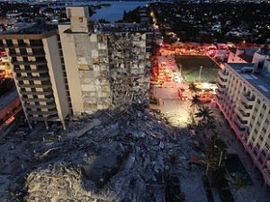
Champlain Towers collapse. photo from Wikipedia

The recent collapse of the Champlain Towers in Surfside, Florida, has cast a spotlight on numerous issues concerning building maintenance, private and public decision-making processes, potential (but highly uncertain) corrosive impacts of sea level rise, and even the continuing exposure of rescue workers to COVID-19, in addition to environmental and occupational hazards. That is all in addition to the governance questions surrounding condominium boards, given the news of past debates about deferred but expensive maintenance once consultants revealed structural deterioration in the 12-story complex.

I wish to be clear about my purpose in writing this post. As an urban planner and researcher, I have doggedly sought to focus on known facts and accurate assessments of hazardous situations of any type. Sometimes, the truth is clear enough. In others, it is wise to withhold judgment while raising questions that deserve thoughtful answers. In this instance, there are so many aspects to the story of the condo building collapse that caution is the appropriate approach because new facts seem to emerge daily. One question—why the North Tower did not collapse while the South Tower did—may compel further inquiry on the role of condo boards in driving decisions about investing in maintenance before catastrophe strikes, but further investigation may reveal many nuances to that story as well. Complete answers are not always simple or obvious.

I have no intention of rushing to judgment on the tragedy in Surfside. But I do wish to focus on one issue that I know is endemic to housing development on a nationwide basis: the roles and responsibilities of homeowners associations (HOA) for managing and maintaining property. Condo boards are one specific subset of HOAs, based on the nature of the buildings. But the issues are not limited to such buildings; they can easily affect the management of townhouse developments and gated subdivisions as well.

Five years ago, when the American Planning Association (APA) and the Association of State Floodplain Managers (ASFPM) collaborated to produce a Planning Advisory Service Report, Subdivision Design and Flood Hazard Areas, we confronted one ticklish issue that concerned us greatly, albeit with regard to flood (and some other natural) hazards rather than structural integrity of tall buildings. The underlying issue, however, dealt with the capacity of privately governed homeowner associations to manage, finance, and maintain hazard mitigation infrastructure over time. Of course, one can easily broaden the definition of such infrastructure to include structural integrity repairs in a situation where buildings can potentially collapse, just as it might include the need to maintain the structural integrity of bridges to prevent such tragedies as the collapse of the I-35 bridge over the Mississippi River in the Twin Cities in 2007. There is considerable room for flexibility in defining the issue so long as the focus remains on public safety.

Our concern at the time was the potential for a financially challenged homeowners association or special district to fail to maintain critical infrastructure before a natural disaster leads to catastrophic failure, whether because of flood, landslide, earthquake, or wildfire, among other possibilities. Chad Berginnis, the executive director of ASFPM, alerted us to an article published by two lawyers involved in owner association litigation in California, Tyler Berding and Stephen Weil. They offered several examples of such situations including Bethel Island, which sits in the Sacramento Delta and includes about 2,500 residents whose homes are protected by more than 11 miles of levees that

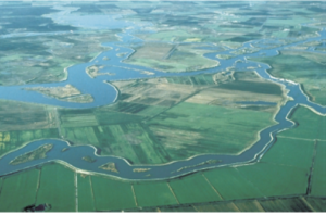
USGS photo of Sacramento-San Joaquin Delta in California

circle the island, just 12 miles from the Greenville Fault. Throughout the Sacramento-San Joaquin Delta, the potential cascading impact of an earthquake triggering massive flooding with failed levees is a nightmare of major proportions. However, residents had defeated a proposed parcel tax to finance improvements through the Bethel Island Municipal Improvement District (BIMID), leaving the district broke and laying off staff. Berding and Weill offered a series of suggestions for better planning and management of these situations.

Whether the case involves a special district like BIMID or special assessments imposed by an owner association board, the issue is the local or private responsibility for financing and maintaining the protective infrastructure to avert such tragedies. Disasters are almost never solely a function of natural forces affecting human communities. They are also a function of the location, condition, and resilience of those communities, and the greater the exposure, the greater is likely to be the long-term cost of restoring that resilience over time to prevent catastrophic loss. In many cases involving floods, landslides, or earthquakes, insurance may be unavailable or financially problematic. The ultimate result can be a bankrupt association and property owners who cannot recover their losses, let alone rebuild, yielding a combination not only of loss of life and property, but of financial calamity as well.

Pad-mounted Transformer in a floodplain not elevated. Photo by Chad Berginnis from PAS Report, used with his permission.

In the report, we sought in several ways to address the issues posed by these dilemmas. We noted, for instance, that as of 2016, the Community Associations Institute reported that 66.7 million people, about 20 percent of the U.S. population, lived in some 333,600 common-interest communities, 55 percent of which were homeowners associations, the rest either condominium or other community associations. One result is the transfer of responsibility for infrastructure within a subdivision from the municipality permitting it to the HOA itself. The long-term problem is that association leadership not only changes over time but often lacks expertise pertaining to the significant risks and responsibilities involved. We suggested that local planning and other agencies extend technical assistance to overcome this gap. This gap, however, remains a serious problem in many communities. When disaster strikes, the idea of having shifted responsibility will become transparently short-sighted because the city or county will be providing emergency response and assistance, just as is happening in Surfside. It is impossible to ignore a disaster.

We noted that many such associations assume responsibility for stormwater infrastructure, such as detention ponds, seawalls, and levees, or even private dams. If they fall into disrepair, the flooding consequences can be severe, so provisions for inspection and maintenance are critical. It is vital for such association boards to understand, for instance, that levees are never totally flood-proof and failure can have various causes. Privately built and owned levees exist across the nation, many in poor condition, according to the American Society of Civil Engineers.

In short, these owner associations have assumed responsibility for some key areas of local flood risk management, including ponds, spillways, erosion and sediment control, flood control structural repairs, drainage improvements, managing vegetation that reduces flood risk, bridge maintenance, and open space management, among other possibilities. Given the potential financial and expertise limitations of these private associations, it may be incumbent upon local governments, in approving development, to assert some degree of control over the standards for approval, for which we offered several major recommendations for requirements related to maintenance costs and final plat approval.

There is, in the end, no perfect way to ensure adequate protection against disaster, but we were hoping to raise the level of concern and discussion, and attention to detail, in the relationships between local governments and owner associations as a way to avert tragedy and financial meltdown following disaster. It is not my intent here to explore the issue in depth but to introduce readers to the depth of the questions that these situations entail. Those wishing to learn more can follow the links to additional resources.

Jim Schwab

Climate Solutions, Off the Shelf

About six weeks ago, as the Biden administration was first asserting its priorities regarding climate change and the environment, I reviewed a book about the positive actions already being taken by cities around the world in addressing the climate crisis. The important takeaway was that, while climate policy languished or moved backwards under the Trump administration, cities and their mayors had not waited for national governments to act. They had instead taken the initiative.

But city governments are not alone. Architects, planners, engineers, and even developers have innovated in their own ways. In late 2019, Chicago architect Douglas Farr provided me with a copy of his book, Sustainable Nation: Urban Design Patterns for the Future, and I promised to review it. It is a sizeable, oversize, 400-page tome, but don’t let that intimidate you, even if I got sidetracked for numerous reasons and only a year later decided to devour the book from cover to cover. That is not necessary for everyone. The book functions much like an encyclopedia, reference work, or anthology. Farr solicited specialized contributions from numerous practitioners and experts. Pick a chapter, pick your favorite subtopic, or dive in randomly. You won’t fail to learn something, as I did, despite my general familiarity with Farr’s subject matter.

My timing in finally reviewing the book has proven fortuitous, in a way. It allows me to expand the message of the review of David Miller’s Solved, a much shorter book by a single author. Miller essentially is a success storyteller; Farr is a documenter. Both serve a purpose.

For 650,000 years, global carbon dioxide emissions have never been above the read line. They are now. All graphics courtesy of Farr Associates

Farr starts his book with a “Where We Are” section that includes color-coded maps documenting the huge disparities around the world in longevity (50-59 years in much of Africa, 70-79 in the U.S., above 80 in Japan, Australia, Canada, and Europe, in poverty, gender inequality, and so forth. A simple chart of global CO2 levels demonstrates that, within our lifetimes, we have nearly doubled atmospheric carbon dioxide concentrations to levels not seen in the last 650,000 years. A parade of such graphics makes clear that ours is a planet on a collision course with natural reality.

The Bullitt Center. Copyright Nic Lenoux for the Bullitt Center.

But such searing images also clarify the importance of examples of what can be done. Farr leads us to the specific example in Seattle of the Bullitt Center, which he terms the “most sustainable office building in the world.” Composting toilets use an average of two tablespoons of water per use. There are no parking spaces, but there is 243 square meters of rooftop green space. The Bullitt Center earned designation as one of the first eight buildings to achieve full certification under the Living Building Challenge, and the first office building.

But no one in Seattle wants it to retain such titles. They would rather see new buildings and new developments claim new titles and surpass the Bullitt Center’s achievements as we move toward an entire new sustainable society. Farr takes us from “our default world” to “our preferred future,” with a procession of examples of how this can be done, then leads readers to a theory of change that discusses how we make change happen, over what timelines, and how we can step on the gas with “acceleration strategies” to make practical impacts on climate change happen more quickly.

But it is in the final section, “The Practice of Change,” which dominates more than half the book, where Farr enlists a variety of expert contributors to share the methods and designs that will carry us forward to reduce climate impacts and ultimately create a more livable society. This is not just about innovative building design but about human relationships. Mary Nelson, president and CEO emeritus of Chicago’s Bethel New Life Inc., and one of the pioneers of Chicago neighborhood change whom I most admire, discusses how we build strong relationships between people and place (spoiler alert: it involves hard work). Others describe the value of participatory art in communities or the need to transform public spaces into welcoming places (Fred Kent, president, Project for Public Spaces). Get the point? Architectural or planning solutions that have no human connection of involvement beyond an elite are dead letters in promoting real social change that will have any impact on our climate crisis. It’s all about us, whether the subject is local food culture, local planning checkups, ore re-envisioning underutilized space to promote equitable prosperity. Every single example has its champion in this book, someone who has worked on solutions and involved people in finding answers.

For a moment, I’d like to focus on contributions by two colleagues with whom I have worked, David Fields and Tom Price, to make the point. Fields is a veteran transportation planner now working in Houston as the city’s chief transportation planner, who discusses how elements of the urban setting such as residential density and mixed land uses that put homes within walking distance of retail, or put homes above ground-floor retail, can reduce vehicle trips by up to 90 percent, thus helping to reverse the tremendous negative impact of the automobile on the world’s climate, to say nothing of air quality. Price, on the other hand, is a civil engineer, instructs us on how to use “every project as an opportunity to process rainwater and stormwater,” while demanding beauty through improved design. His articles remind me of a lesson I learned years ago, after Hurricane Katrina, through a project in New Orleans called the Dutch Dialogues, in which the American Planning Association and others engaged with Dutch planners and engineers to promulgate the idea of seeing water not as the enemy but as a resource for enhancing urban quality of life. We need to find ways to help move water elegantly through the city instead of constantly finding ways to bury it, hide it, or divert it.

Whether the subject is community theater, transportation, or architectural styles that build housing affordability and reduced heating and cooling demands to reduce greenhouse gas emissions, the overall point is not only repetitive but cumulative: For many of the challenges that climate change poses to our communities, we already know the answers if we are willing to explore the most innovative, effective, and creative approaches that others have already used. Yes, we have a new administration willing to rejoin the Paris climate accord and invest in solutions to climate change. That is important, as we need to push envelopes constantly and with urgency. But we dare not ignore the answers that are all around us in the innovations that are already helping our communities adapt to a carbon-neutral, democratic, more equitable future. They embody the lessons that, through replication, will accelerate our shift to a green future that eases the existential climate crisis of our planet.

The sweet-spot scale in action in Oslo, Norway. Copyright Jason F. McLennan.

Perhaps two points in Farr’s book, side by side, will help illuminate the point. One is a segment by Jason F. McLennan, founder of the Living Building Challenge. He defines something he calls the “sweet spot” in the sustainable urban fabric, buildings between four and eight stories high. These are buildings not so high as to isolate people on upper floors from fellow human beings at ground level. The building is also not so tall that reliance on energy-consuming elevators drives high energy demand for the building merely to function. There is a place for taller buildings, but the combination of density and manageable energy demand with the potential to minimize demands on the environment exists in that “sweet spot.” Subsequent examples in the same section

The sweet spot defined. Modified by Farr with permission from Jason F. McLennan.

proceed to elaborate on ways we already know to produce affordable, carbon-neutral housing. At the end of the book, in contrast, Farr makes his plea, in large part to fellow architects, to “end the race to build the world’s tallest building,” detailing the negative effects of such edifices on public health, safety, and welfare, and ending with a quote from Sherrilyn Kenyon, “Just because you can doesn’t mean you should.” Indeed. That is the fundamental point of stranded carbon, that is, leaving fossil fuels unburned, in the ground, and shifting to a renewable energy economy.

Much of the secret of achieving this goal lies in knowing when to stop doing the wrong things and how to enable our society to do more of the green things. This being merely a blog post, I cannot attempt to share all the specific points Farr and his contributors make concerning street design, building envelopes, solar power, social equity, and commitment to environmental health. But I can urge you to seek out his book, in a library, online, or in a bookstore, to find the examples you need for the situation your own community faces in crafting a more sustainable future. This is the activist’s and practitioner’s manual to help get you started. Let’s all engage in some creative thinking and problem solving.

Jim Schwab

Great Lakes Merit Protection

I grew up near the shores of Lake Erie, in suburban Cleveland. After a seven-year stint in Iowa and Nebraska, I ended up in Chicago, where I have lived since 1985. The Great Lakes have been part of my ecological and geographic consciousness for essentially 90 percent of my lifetime. As an urban planner, that means I am deeply aware of their significance on many levels.

It will surprise no one, then, that as a planner who has focused heavily on environmental and natural hazards issues, I have been involved in projects aimed at protecting that natural heritage. As manager of the Hazards Planning Center at the American Planning Association (APA), I involved APA as a partner with the Association of State Floodplain Managers (ASFPM) as ASFPM developed its Great Lakes Coastal Resilience website with National Oceanic and Atmospheric Administration (NOAA) support. Later, I prepared a successful grant for support from NOAA’s Sectoral Applications Research Program for a project on integrating climate change data into local comprehensive and capital improvements planning. In that project, APA collaborated with the Chicago Metropolitan Agency for Planning and the University of Illinois. That project, which involved work with five pilot communities in the Chicago metropolitan area, was (and still is) ongoing when I left APA at the end of May 2017. The aim was to develop applicable models for such planning for other communities throughout the Great Lakes region.

It is thus always encouraging to see others pick up the same mantle. It was hardly surprising that the Environmental Law & Policy Center (ELPC), a long-time Chicago-based staple of the public interest community, would see fit to do so. On March 20, in concert with the Chicago Council on Global Affairs, ELPC released “An Assessment of the Impact of Climate Change on the Great Lakes,” with 18 scientists contributing to the 74-page report. I spoke two weeks later with Howard Learner, the long-time president and executive director of ELPC, about the rationale and hopes for the report.

The impact of adding one more report to the parade is cumulative but important. Learner explained that national studies, particularly the National Climate Assessment, mention regional impacts of climate change, but that drilling down to the impacts on a specific region and making local and state decision makers aware of the issues at those levels was the point. Thus, he asked Don Wuebbles, an atmospheric scientist at the University of Illinois and a science adviser to ELPC, to assemble a team of experts for the purpose. Wuebbles recruited most of the team, with the goal not only of identifying problems but of developing or pinpointing solutions. Repeatedly, Learner emphasized the public policy role of ELPC as a “problem-solving” institution. The intended audience was governors, provincial ministers, congressional delegations from Great Lakes states, and other public officials, providing them with an assessment of the state of the science concerning the Great Lakes.

I won’t even attempt to review all the data in the report, but certain points are essential to an adequate public understanding. For one, the Great Lakes are simply huge and constitute a very complex ecosystem in a heavily populated region of more than 34 million people in the U.S. and Canada, the vast majority of whom repeatedly express support for protection of the Great Lakes in public opinion polls. It is the largest freshwater group of lakes on the planet, and second largest in volume. It is a binational ecosystem that demands cooperation across state, provincial, and national boundaries. It is home to 170 species of fish and a $7 billion fisheries industry. It has long been home to one of the most significant industrial regions of both nations. What happens here matters.

The term “lake effect” is most often associated with the Great Lakes because their sheer mass has a measurable impact on local and regional weather patterns. Winds pick up considerable moisture that often lands downwind in the form of snowstorms and precipitation. For instance, any frequent visitor of farmers’ markets along the Great Lakes is likely to be aware of western Michigan’s “fruit belt” offerings of apples, cherries, pears, and other crops dependent on the lake effect.

Figure 3. Observed changes in annually-averaged temperature (°F) for the U.S. states bordering the Great Lakes for present-day (1986–2016) relative to 1901–1960. Derived from the NOAA nClimDiv dataset (Vose et al., 2014). Figure source: NOAA/NCEI (Both images reprinted from report courtesy ELPC.

Figure 4. Projected change in annually-averaged temperature (°F) for U.S. states bordering the Great Lakes from the (a) higher (RCP8.5) and (b) lower (RCP4.5) scenarios for the 2085 (2070-2099) time period relative to 1976-2005. Figure source: NOAA/NCEI

The lake effect, of course, is a part of the natural system in a region carved out of the landscape by melting glaciers at the end of the last Ice Age. Recent climate change is another matter. The region has already experienced a 1.6° F. increase in average daily temperatures in the 1985-2016 period as compared to the 1901-1960 average. Those increases are expected to accelerate over the remainder of this century. It is not just temperatures that change, however, because changing weather patterns as a result of long-term climate change result in altered precipitation patterns. Summer precipitation is predicted to decline by 5 to 15 percent, suggesting some increased propensity for drought, while winter and spring precipitation will increase, producing an increased regional propensity for spring flooding. Increased intensity of major thunderstorm events will exacerbate the vulnerability of urban areas to stormwater runoff, resulting in increased “urban flooding,” often a result of inadequate stormwater drainage systems in highly developed urban areas. That, in turn, has huge implications for municipal and regional investments in stormwater and sewage treatment infrastructure. In addition, heat waves can threaten lives and public health. Public decision makers ignore these implications at the fiscal and physical peril of their affected communities.

Among those impacts highlighted in the report is the increased danger of algal blooms in the Great Lakes as a result of changing biological conditions. The report notes that the largest algal bloom in Lake Erie history occurred in 2011, offshore from Toledo, Ohio, affecting drinking water for a metropolitan area of 500,000 people.

There is also danger to the stability of some shoreline bluffs, an issue highlighted on the Great Lakes Coastal Resilience website, as a result of reduced days of ice cover during the winter. While less ice cover may seem a minor problem to some, in fact it means changes in water density and seasonal mixing patterns in water columns, but it also means the loss of protection from winter waves from storm patterns because the ice cover prevents those waves from reaching the shore until the spring melt. The result is increased shoreline erosion.

All of that harks back to the central question of my interview with Learner: What do you hope to achieve? “The time for climate action is now,” he insisted, noting that the Trump presidency has been “a step back,” making it important for cities and states to “step up with their own climate solutions.” Learner hopes the report at least provides a “road map” for governors and Canadian premiers to focus their actions on the impact of climate change on the Great Lakes, such as “extreme weather events.”

Curiously, one arena in which new action may be possible is the city of Chicago itself, which on April 2 elected a new mayor, Lori Lightfoot. Media attention has focused on the fact that she is both the first gay mayor and the first African-American female mayor in the city’s history, but equally significant is her history as a former federal prosecutor who campaigned against corruption. Learner notes that outgoing Mayor Rahm Emanuel convened a Chicago Climate Summit in November 2017, and that ELPC is now “looking to Mayor Lightfoot to step up Chicago’s game” to benefit both the local economy and environment with a stronger approach to climate change.

The same can be said, of course, for numerous other municipalities choosing new leadership and for the new governors of the region, including J.B. Pritzker in Illinois. They all have much work to do, but an increasing amount of research and guidance with which to do it.

Jim Schwab

Mitigation Challenges on the Florida Gulf Coast

Hillsborough County is a dense metropolitan area, anchored by the city of Tampa. Tampa and nearby St. Petersburg, in Pinellas County, sit on opposite shores of Tampa Bay, a 400-square-mile expanse of water connected to the Gulf of Mexico. Across that gap sits the Sunshine Skyway Bridge, a magnificent and scenic section of I-275. On a sunny day, it displays coastal Florida in all its glory.

Eugene Henry, like anyone else, enjoys those sunny days, but he also worries about what may happen when the region suffers inclement weather. As Hillsborough County’s Hazard Mitigation Program Manager, it is his job to think about how well the area will fare under the impact of natural and other disasters, which can include hurricanes, floods, tornadoes, sinkholes, and wildfires. At least the first two are complicated by sea level rise, and one can easily argue that climate change in a broader sense may well influence the damage from wildfires. For those uninitiated in the particulars of Florida’s natural environment, wildfires are a recurring feature. In what is ordinarily such a lush environment fostered by rain and abundant sunshine, it takes only one drought year amid high heat to turn dense vegetation into a tinderbox. It has happened before, repeatedly.

But the biggest concern, by far, is the arrival of the Big One, the high-intensity hurricane that the county readily admits it has escaped in recent decades. In its Post-Disaster Redevelopment Plan (PDRP), the county states forthrightly that this is merely a matter of good fortune and that planners fully understand that the day will surely come—and that they had best be ready for it. Disaster resilience in the face of hurricanes is not a matter to be taken lightly with 158 miles of shoreline along Tampa Bay, numerous rivers and streams, and numerous vulnerable, low-lying areas. Absent serious attention to mitigation, damages from a Category 4 or 5 hurricane, or one like Harvey that stalls and dumps voluminous rain on an urban area, could become catastrophic.

But Tampa and Hillsborough County have been very fortunate. The last Category 3 hurricane struck the area in 1921. What may have been a Category 4 struck in 1848, though wind speed measurements were primitive at the time, and the U.S. had no official records yet. According to the county’s Local Mitigation Strategy, that storm “reshaped parts of the coast and destroyed much of what few human works and habitation were then in the Tampa Bay area.” Tides rose 14 feet. Tampa was still a small city then, and Gene Henry wonders about the staggering losses that might occur with a comparable event today.

I had long wanted to visit the area to see in person how these issues are being addressed. I have known Gene for a long time, and I have read the county’s PDRP, an extensive document laying out the county’s preparations for recovery from disasters. But I had never been to Tampa. As the result, however, of a personal invitation from a high school classmate, David Taylor, who now lives in Sarasota, my wife and I flew to Tampa February 20 and stayed with Dave and his wife, Linda, for five days. Sarasota is about one hour’s drive south of Tampa. As part of the trip, I arranged to meet with Gene the day after we arrived and tour the county to see the hazard mitigation projects underway there. I also delivered a one-hour lecture the following afternoon in West Palm Beach, on behalf of Florida Atlantic University, as part of a two-hour program that included a panel discussion following my talk on “Recovery and Resilience: Facing the Disasters of the Future.” Not one to skip a learning opportunity, Gene drove four hours from Tampa to attend the program.

But back to Hillsborough. My wife and I met Gene at the county’s Emergency Operations Center (EOC) around mid-morning, hopped in his county truck, and took off. Our first stop was the Florida Center for Design + Research, housed in the School of Architecture + Design at the University of South Florida (USF), Gene’s graduate alma mater. The school features an urban planning program where he wanted us to meet Professor Brian Cook. Planning students often take studio classes, which involve design or research work on real-life community problems. Students learn to define a community design or policy issue, work with clients, and try to produce solutions that will be of some practical value to the community they are serving. They typically work in teams. In this case, students were applying geographic information system (GIS), or mapping, skills to determine areas of high vulnerability to flooding and sea level rise in less affluent neighborhoods. Gene’s county office collaborates with USF instructors to identify areas of practical concern for the students’ work. The photos show some of the design work the students have done, the best of which is often displayed in poster sessions at state and national professional planning conferences.

Posters (above and below) from the USF design studio

The most encouraging aspect of that visit was, for me, the mere fact that the students are engaging with such a pressing problem. I have researched the issue of hazards and climate change in the planning curriculum for both undergraduate and graduate degree programs in urban planning, and most such programs are lacking in this respect, a situation that is disserving the planners of tomorrow who must be well trained to come to grips with these challenges in whatever communities they end up serving. But a growing number of students are getting such training—I have myself been teaching such a course at the University of Iowa since 2008—and southern Florida is as good a laboratory as they could wish for. To see collaboration between a county agency and USF graduate students and faculty is a most welcome note.

But Gene had other places to take us in the afternoon, besides, that is, the Cuban-themed La Teresita restaurant where we ate lunch—a place I am willing to recommend if you ever visit Tampa.

First up in the afternoon was the University Mall area north of downtown Tampa and just east of I-275. This involves a stormwater management and flood-mitigation project in an area subject to a certain amount of repetitive loss, meaning that the same properties continue to suffer periodic flood losses. The project removed structures while creating additional areas for stormwater storage and reshaping a natural area known as Duck Pond, thus creating a system for stormwater conveyance. This includes a large stormwater pump that transfers slow-moving stormwater to areas further downstream and, in due course, to a reservoir owned by the City of Tampa. Before this project was initiated, storms used to inundate multifamily apartment buildings, Gene says, as well as a nearby assisted living facility. How does the county pay for all this? He credits a combination of local funds, which is certainly not unusual, and federal money in the form of Hazard Mitigation Grant Program (HMGP) funds. The latter are available as part of an overall recovery package after a Presidential Disaster Declaration, but require that purchased properties, once cleared, remain in perpetual open space. The point is to ensure that a vulnerable area is not redeveloped, thus perpetuating the problem.

At 132nd Street, also in Tampa, another flood-mitigation and stormwater management project presents a very different appearance. This too was subject to repetitive loss and required protection from urban flooding, which is typically the result of poor stormwater drainage in developed areas. The problems can include poor water conveyance from one area to the next—the nearby highway provided an impediment to drainage—and high levels of impervious surface, meaning coverage with concrete and structures that limit percolation of water into the soil. In this case, a small subdivision suffered repetitive flooding even with small storms. Here also, the county acquired homes with HMGP funds, which are dispensed by the Federal Emergency Management Agency (FEMA). The streets were removed, and stormwater ponds were added.

This was a location where the county’s partnership with USF paid dividends. Researchers analyzed which plants were best at removing nitrogen and other chemicals common in stormwater runoff in order to clean up the water before it reaches Tampa Bay. Henry says this project was made possible through a combination of local and HMGP funds in combination with federal Community Development Block Grant entitlement money.

I included the chain link in my photo to show that the solution may not be complete. After all, chain link fences are intended to limit access. What consideration, I asked, had been given to eventually converting this cleared area to some sort of public park and thus facilitating a public benefit? There can be challenges in part because of pollution cleanup and other public safety factors. Gene readily admitted he would love that solution, but it may take time. The adjoining neighborhood must be comfortable with that use, which can involve solving various site-related problems. A nearby church might be a potential ally, serving as a patron and watchdog, but reaching agreement about solutions and responsibilities, including ongoing maintenance and supervision, takes time. And only time will tell whether such a solution materializes with the support of local public officials.

Some projects assist a single homeowner with a stubborn problem. This is often the case with homes that are elevated, a common site in parts of the Southeast, where coastal and riverine flooding can wreak havoc with homes in vulnerable locations that do not necessarily require buyouts and relocation. That was the case near Rocky Creek, where a homeowner rebuilt a structure elevated three feet above base flood elevation (BFE) using a combination of private funds and a Flood Mitigation Assistance (FMA) grant from FEMA. The result is living space that is better protected when flood waters surround the lower level.

The same story occurred at a home near the Alafia River, where another homeowner was elevated three feet above BFE, using the same combination of funds.

Gene also shared with us an interesting strategy at a frequently flooded and highly vulnerable modular home park, where an area had been cleared of its former homes to allow repopulation with recreational vehicles (RVs). The logic is that, when flood warnings arrive, RV owners will be able, unlike those with more stationary modular homes, to simply drive off the site to safer areas until the emergency subsides. The initiative, Gene says, was taken by the park’s new owner (which owns other parks nationwide), which identified no more permanent structures in the floodway as part of its compliance strategy after the most recent flooding event in the area.

This area is slated for RV occupancy only.

Finally, we returned to learn a little about the EOC. We visited what is often known in such centers as the “war room,” where designated officials meet to discuss and establish strategies for dealing with an emergency of any sort that activates the emergency operations plan. In the photo, each chair is designated for a specific official, with groups of people with related tasks seated in color-coded sections of the room. Many such EOCs are much smaller, but Hillsborough County is very urban and populated, and the needs are complex and interrelated. It is expected that those involved will arrive with authority to respond to the disaster, to indicate what they are and are not capable of doing as part of the overall response to disaster. It is not a place where one expresses a need to go back to another office and “find out.”

Hillsborough County Emergency Operations Center “war room”

Ready to relax and enjoy a drink and a snack, we followed Gene down the highway to the Sunset Grill at Little Harbor, which has a beautiful view of the bay. At dusk, numerous people followed a daily ritual of photographing the sunset over the water. Tourist attraction it may be, as well as a local watering hole, but the surrounding area has a significant mangrove forest and salt-bed areas that were preserved as open space using Environmental Land Acquisition Funds from what Gene describes as a “locally instigated preservation program.”

Hillsborough County’s Hazard Mitigation Program Manager, Eugene Henry, at rest at Sunset Grill at the end of our day-long tour.

And so, with the sun declining in the west, we sat at an outdoor table and hashed over the world’s problems, and sometimes our own. One point that seems clear to me is that Hillsborough County has a great deal to offer to other jurisdictions, just as it has undoubtedly learned a great deal as well—one reason both he and a resident scholar and Japanese graduate student from the University of Illinois, Kensuke Otsuyama, planned to drive to West Palm Beach the next day to hear my presentation. Although there is sometimes a tendency for local governments to become more insular, to allow fewer opportunities for employees like Gene to share and exchange information in professional forums and conferences, this, I think, is always a mistake. The growth in the value of what someone like Gene does lies in this fruitful sharing of experience and perspectives that such opportunities allow, and I hope that will continue, for certainly Gene made my day by sharing his time to allow me to learn and to share with the growing readership that follows this blog.

Supplemental Comment:

Although the hearing was held today, making live streaming a moot point, significant written and recorded testimony on hazard mitigation and climate resilience issues occurred before the U.S. House Appropriations Subcommittee on Transportation, Housing, and Urban Development. Yesterday, the following link was made available from several sources including the American Planning Association (APA) to provide access to this testimony and information:

Representatives from APA, PEW, Houston Public Works, Rutgers University, and the Town of Arlington, MA are delivering testimony to the Transportation and Housing and Urban Development (THUD) congressional subcommittee tomorrow, March 13th at 10:00 a.m. EST. THUD, a part of the House Committee on Appropriations, writes laws that fund the federal government’s important responsibilities. The testimony is available for streaming here:

https://appropriations.house.gov/legislation/hearings/stakeholder-perspectives-building-resilient-communities

APA will submit written testimony that will be put into the Congressional record. The testimony will be available on APA’s website tomorrow.

Jim Schwab