Disaster Mitigation Act at Twenty

When a law makes a powerful impact over time, it is sometimes hard to remember what life was like before it was enacted. In U.S. history, for example, both Social Security and, later, Medicare, created a new reality for the elderly that makes it almost impossible for most people to imagine what old age meant before they took effect. They are so much a part of the fabric of American life that some people even forget (or never learn) the social and political debates that produced them. That sort of obtuse amnesia was in evidence as Tea Party protests materialized in response to the Affordable Care Act, aka Obamacare, in which some carried signs that read, “Keep Your Government Hands Off My Medicare.” Ponder that conundrum for a while.

Few laws match the scale of impact of those two examples, but many have significant impacts that receive less attention, at least among the general public. One that is reaching its twentieth anniversary is the Disaster Mitigation Act (DMA), signed into law by President Clinton on October 30, 2000. After a decade of expensive disasters in the 1990s—Hurricane Andrew (1992), the Midwest floods (1993), the Northridge earthquake (1994), and Hurricanes Fran (1996) and Floyd (1997)—Congress realized that the nation needed greater accountability from states and local governments in addressing hazard mitigation challenges before disasters occurred. The carrot and the stick were combined in this instance in a requirement that states (including territories and the District of Columbia) and local and tribal governments prepare and adopt hazard mitigation plans that won the approval of the Federal Emergency Management Agency (FEMA) as meeting the standards of the act and its accompanying regulations as a condition of eligibility for FEMA hazard mitigation grants. Put simply, no plan, no money. Few state and local officials wish to find themselves in that position after a major disaster.

Congress went one step further. Previously, most such grants came through the Hazard Mitigation Grant Program (HMGP), created under the Stafford Act in 1988, the basic law structuring the federal disaster response system, under which every state has some sort of parallel emergency management agency. The problem with HMGP has always been that the money is made available as part of a presidential disaster declaration, using a percentage of overall disaster assistance to determine the amount available. That money goes to the affected states, which are responsible for local allocations. But that means that a state must experience a natural disaster to be eligible for such money. Admittedly, it then becomes useful for mitigating future disasters, but it did nothing to avert the most recent event. In fact, communities that had become adept at mitigating hazards with their own resources often complained that they got no federal assistance because they were doing too good a job of preventing losses. Davenport, Iowa, for example, long ago refused Army Corps offers to build levees along the Mississippi River and opted for a riverfront park that allowed the water to flow without damaging buildings in its downtown. Davenport has not always avoided flood impacts, but it has certainly minimized them.

In DMA, Congress added a new Pre-Disaster Mitigation (PDM) grant program. Instead of being triggered by disaster declarations, it was an annual grant competition, in which state and local governments submitted proposals for projects that would reduce losses of life and property in future events. Its major flaw was that PDM relied on annual congressional appropriations, which predictably ebbed and flowed and often was grossly underfunded. In 2018, in the Disaster Recovery Reform Act, Congress finally opted to stabilize funding by creating a formula by which six percent of total annual disaster relief outlays would be swept into a single pot by FEMA for grants under a new program that FEMA has labeled Building Resilient Infrastructure and Communities (BRIC), which I discussed in a post here in early August. The resulting 2020 grant funds total roughly $500 million, a far cry from years past when the total congressional allocation was often as little as $25 million, which barely put a dent in the mitigation needs of a nation as vast as the U.S.

But the real question after two decades is, How has DMA changed the landscape of American planning and disaster management? Clearly, we have not solved all problems. For one thing, climate change has accelerated and complicated matters significantly. While Congress unquestionably has dithered a great deal on climate issues, DMA was never aimed directly at climate change. Instead, it aimed to create a climate of state, tribal and local responsibility and accountability for planning for hazard mitigation while making federal funding available to support such planning. In fact, federal assistance for such planning is built into the law. Have governments responded?

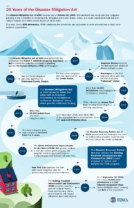
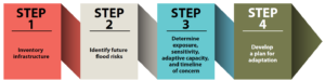
DMA timeline produced by FEMA, reused from FEMA website. To expand, click here.

The unequivocal answer is yes. By 2002, once FEMA had finalized its guidance for the mitigation planning process, Clackamas County, Oregon, became the first local jurisdiction to win approval for its plan. Within a few years, every state and territory had an approved plan in place. Winning compliance from most local jurisdictions understandably took longer, but today FEMA can claim that more than 23,000 local units of government have approved plans, as do 239 tribal governments, which together cover more than 84 percent of the U.S. population. The gaps in coverage are primarily in rural areas, many of which suffer from low governmental capacity—a subject that can still be addressed in future outreach by FEMA—and some of which simply choose not to plan, presumably not seeing the consequences as outweighing the burden of the work involved.

In the meantime, many professional and intergovernmental associations have done considerable outreach to their own members to explain the benefits of hazard mitigation planning beyond simple eligibility for grants. For example, during my tenure at the American Planning Association, we used a FEMA contract to produce a Planning Advisory Service Report on the benefits of integrating such planning throughout the local planning process, including comprehensive plans, capital improvements programming, and the land-use regulations that implement mitigation intentions, such as zoning, floodplain management, and subdivision ordinances. We published Hazard Mitigation: Integrating Best Practices into Planning in 2010. The concept of integrated planning has enjoyed significant increased attention throughout the second decade of DMA and has become a staple of FEMA guidance for local hazard mitigation planning.

There are many ways to review this history, which may even be worth an entire book. As for what we have achieved, the Natural Hazards Center, based at the University of Colorado, asked me to moderate a webinar on October 13. “The Disaster Mitigation Act of 2000: Twenty Years of Promise, Pitfalls, and Progress from a Planning Perspective,” in which I was joined by three experienced and insightful panelists from state, county, and federal government, provides a fast-paced, one-hour summary of the successes, shortcomings, and future challenges of DMA as part of the Center’s Making Mitigation Work webinar series, and the recorded version is available at the link above. I thank NHC Director Lori Peek for having invited me to lead this discussion.

Make it your DMA anniversary experience. Trust me, it will be worth your time.

Jim Schwab

The Need for Resilient Infrastructure

This summer, the Federal Emergency Management Agency (FEMA) is at last rolling out its Building Resilient Infrastructure and Communities (BRIC) program, and its first Notice of Funding Opportunity will likely be issued in September. In July, FEMA is airing a series of five weekly webinars to introduce BRIC to communities and state officials around the nation. BRIC is the practical result of provisions in the Disaster Recovery Reform Act, passed by Congress in 2018, to create a secure funding stream for what was formerly the Pre-Disaster Mitigation program. I plan to discuss all that in coming weeks on this blog.

But the personal impact on me was to remind me to attend to an egregious oversight on my part that began earlier this year with the release by the American Planning Association (APA) of a new Planning Advisory Service Report, Planning for Resilient Infrastructure. I read it, attended to some other business in Texas and Nebraska in late February and early March, and along came the coronavirus, upending most of my existing personal and professional plans and refocusing my attention. But it is time for me to give this report the attention it deserves.

First, there is the question of why it deserves attention. The National Oceanic and Atmospheric Administration (NOAA), which funded the project led by the Association of State Floodplain Managers (ASFPM), which partnered with APA, chose their joint proposal in funding the first round of projects under its Coastal Resilience Grants Program in 2016. As Jeffrey Payne, director of NOAA’s Office for Coastal Management, states in his preface, “Tomorrow isn’t what it used to be. Increasingly, coastal conditions include all the risks of the past, but risks that are amplified by a changing climate, rising seas, and more rapidly fluctuating Great Lakes.”

In the interest of full disclosure, I was involved with ASFPM executive director Chad Berginnis in co-authoring the proposal for this project in the summer of 2015. (After I left APA, ASFPM hired me back as a consultant in later stages of the effort to help refine and focus the PAS Report.) Our intent was both simple and bold. Local governments spend tens of billions of dollars annually on the construction and maintenance of various kinds of infrastructure. Much of that infrastructure, related to essential services including water, wastewater, and transportation, is subject to the impacts of climate change. While, as Payne goes on to state, this is true away from the coast as well, some of those impacts are particularly significant and noticeable in coastal states and communities. In short, a great deal of taxpayer money is at stake regarding the ability of that infrastructure to withstand future climate conditions and natural disasters. Planning for greatly increased resilience is a recipe for improved fiscal stability. This holds true even if, as planned by statute, a greater share of that funding for hazard mitigation projects comes from FEMA through BRIC. Taxpayers are taxpayers, whether the money used is federal, state, or local.

All that said, the serious work of completing the work fell to Joseph DeAngelis at APA, now the manager of the APA Hazards Planning Center, and Haley Briel, a research specialist for the Flood Science Center at ASFPM, along with Michael Lauer, a planning consultant with deep experience in growth management programs in southeastern coastal states.

Global average sea level rise from 1880 to the present, based on tide gauges and satellite measurements (US EPA). Reuse courtesy of APA.

Their collaborative report addresses the most significant issues of infrastructure resilience. Particularly in areas subject to coastal storms, these involve not just the impacts of major disasters but the everyday nuisance impacts of flooding because of high tides atop sea level rise that already are yielding closed streets and parks and flooded basements. Urban flooding has become a “thing” where the term never used to be heard. They include a small table with projections by the U.S. Global Change Research Program showing ranges of sea level rise between 0.5 and 1.2 feet by 2050, and 1 to 4 feet by 2100. Of course, these are rough ranges in part because various geological conditions, such as erosion or glacial rebound, cause different results from one region to another, although most of the East Coast faces serious problems over the coming century. A major part of the problem is that sea level rise amplifies the impact of high tides in storms, leading to increased flooding and erosion that is already evident in low-lying cities like Norfolk, Virginia, or Miami. The authors note that, “Over the last half-century alone, with just one to three inches of average sea level rise, daily high-tide flooding has become up to 10 times more frequent” in American coastal communities. Even in Midwestern communities, including those along the Great Lakes, problems result from climate-driven increases in high-precipitation storms that frequently overwhelm stormwater drainage systems built in an earlier era based on other, less challenging, assumptions.

Storm surge heights are cumulatively based on the mean sea level, the height of the tide, and the high volume of water pushed toward the shore by coastal storms (National Hurricane Center). Reuse courtesy of APA.

It is natural that a planning document is going to assert a role for planners in addressing these problems. The role the report asserts is entirely logical, starting with “assessing long-term infrastructure needs and understanding future risks to infrastructure assets.” Equally logical, however, is that the report builds upon prior APA literature to outline the need for coordinated action through the plan-making process to integrate climate risk into local plans as a means of “capturing the future conditions to which existing infrastructure and any planned infrastructure projects will be subjected.” Put simply, if the local planning process does not identify those risks and provide clear recommendations for creating resilient infrastructure, it is not likely to materialize in any coherent and consistent fashion. The third chapter outlines a step-by-step approach (see illustrations below) for developing an inventory of local infrastructure, identifying risks, and moving toward an effective plan for adaptation.

The process for conducting an infrastructure vulnerability assessment (Joseph DeAngelis). Reuse courtesy of APA for both diagrams.


A project or asset’s vulnerability to flood impacts is a product of its exposure, sensitivity, and adaptive capacity (Joseph DeAngelis).

Later, the report provides some examples of what such consistent planning for resilient infrastructure may look like. Its case study of San Francisco’s approach to assessing sea-level-rise impacts outlines how the Sea Level Rise Committee of the city’s Capital Planning Committee (CPC), a body responsible for overseeing capital investments for infrastructure, recommended using the upper end of estimates from a National Research Council report for the West Coast. These were fed into a CPC guidance document for assessing vulnerability and supporting adaptation to sea level rise, a primary outcome of climate change. Without engaging the full details here, the bottom line is that the City and County of San Francisco was working from a single play book for climate adaptation of project life cycles for future infrastructure. Capital planning could thus proceed in a more standardized manner based on common assumptions. The report also uses an extensive example from Toledo, Ohio, the site of one of two pilot projects supported by the ASFPM/APA project. Toledo, sitting on the shores of Lake Erie, has suffered from stormwater flooding and is approaching the problem with a mixture of green infrastructure and analysis of social vulnerability in affected neighborhoods. The report elsewhere delves into questions and methods of documenting and addressing environmental justice and social and racial inequities in environmental protection through appropriate local capital planning projects.

Both cases highlight the value for local planners of establishing credible data sources, which often rest within federal agencies such as NOAA and the U.S. Environmental Protection Agency. But, as one chapter illustrates, these can include experienced national nonprofits as well, such as Climate Central. Unquestionably, however, the best single assemblage of data and tools is NOAA’s own Digital Coast website. Planners can access additional high-quality resources on climate through other NOAA programs such as the Regional Climate Centers, located at a series of universities across the nation, and the Regional Integrated Sciences and Assessments, where RISA staff work directly with climate scientists to communicate the science to the public and local officials.

Just as important as understanding where to find the proper data and tools, however, is a knowledge of best practices in local capital improvements planning, the development of effective standards, guidelines, and regulations for creating resilient infrastructure, and, finally, the best means for financing such long-term investments in infrastructure, especially with an eye to climate resilience. Each of these three topics is covered in separate chapters in the second half of the report.

View of part of the Jersey Shore after Hurricane Sandy, February 2013.

Ultimately, the real challenge for local planners is overcoming a natural discomfort with the inherent uncertainties in planning for infrastructure that must withstand the impacts of climate change within a range of assumptions that, in part, depend on federal and even international action to mitigate rising global temperatures as a result of greenhouse gas emissions. Planners, and the communities they serve, must adjust to those uncertainties and the inherent complexities they embody. Planning, however, has always been a speculative enterprise riddled by uncertainties, yet cities have embraced assumptions about population growth, demographic change, and economic scenarios that have often been equally uncertain, for none of us has a crystal ball. What we do know, however, is the direction of existing and accelerating trends, and climate change is no myth. We are ultimately better off, and will better invest public resources, by anticipating climate change with the best projections available, so that our communities are not overwhelmed by future storms, sea level rise, and storm surge. We cannot say we did not see it coming. We can only hope to say we used a wise approach based on the best data available to avoid catastrophe for ourselves and future generations in the communities we serve.

Jim Schwab