Private Costs of Disaster Prevention

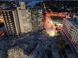
Champlain Towers collapse. photo from Wikipedia

The recent collapse of the Champlain Towers in Surfside, Florida, has cast a spotlight on numerous issues concerning building maintenance, private and public decision-making processes, potential (but highly uncertain) corrosive impacts of sea level rise, and even the continuing exposure of rescue workers to COVID-19, in addition to environmental and occupational hazards. That is all in addition to the governance questions surrounding condominium boards, given the news of past debates about deferred but expensive maintenance once consultants revealed structural deterioration in the 12-story complex.

I wish to be clear about my purpose in writing this post. As an urban planner and researcher, I have doggedly sought to focus on known facts and accurate assessments of hazardous situations of any type. Sometimes, the truth is clear enough. In others, it is wise to withhold judgment while raising questions that deserve thoughtful answers. In this instance, there are so many aspects to the story of the condo building collapse that caution is the appropriate approach because new facts seem to emerge daily. One question—why the North Tower did not collapse while the South Tower did—may compel further inquiry on the role of condo boards in driving decisions about investing in maintenance before catastrophe strikes, but further investigation may reveal many nuances to that story as well. Complete answers are not always simple or obvious.

I have no intention of rushing to judgment on the tragedy in Surfside. But I do wish to focus on one issue that I know is endemic to housing development on a nationwide basis: the roles and responsibilities of homeowners associations (HOA) for managing and maintaining property. Condo boards are one specific subset of HOAs, based on the nature of the buildings. But the issues are not limited to such buildings; they can easily affect the management of townhouse developments and gated subdivisions as well.

Five years ago, when the American Planning Association (APA) and the Association of State Floodplain Managers (ASFPM) collaborated to produce a Planning Advisory Service Report, Subdivision Design and Flood Hazard Areas, we confronted one ticklish issue that concerned us greatly, albeit with regard to flood (and some other natural) hazards rather than structural integrity of tall buildings. The underlying issue, however, dealt with the capacity of privately governed homeowner associations to manage, finance, and maintain hazard mitigation infrastructure over time. Of course, one can easily broaden the definition of such infrastructure to include structural integrity repairs in a situation where buildings can potentially collapse, just as it might include the need to maintain the structural integrity of bridges to prevent such tragedies as the collapse of the I-35 bridge over the Mississippi River in the Twin Cities in 2007. There is considerable room for flexibility in defining the issue so long as the focus remains on public safety.

Our concern at the time was the potential for a financially challenged homeowners association or special district to fail to maintain critical infrastructure before a natural disaster leads to catastrophic failure, whether because of flood, landslide, earthquake, or wildfire, among other possibilities. Chad Berginnis, the executive director of ASFPM, alerted us to an article published by two lawyers involved in owner association litigation in California, Tyler Berding and Stephen Weil. They offered several examples of such situations including Bethel Island, which sits in the Sacramento Delta and includes about 2,500 residents whose homes are protected by more than 11 miles of levees that

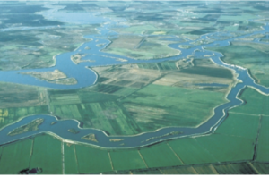
USGS photo of Sacramento-San Joaquin Delta in California

circle the island, just 12 miles from the Greenville Fault. Throughout the Sacramento-San Joaquin Delta, the potential cascading impact of an earthquake triggering massive flooding with failed levees is a nightmare of major proportions. However, residents had defeated a proposed parcel tax to finance improvements through the Bethel Island Municipal Improvement District (BIMID), leaving the district broke and laying off staff. Berding and Weill offered a series of suggestions for better planning and management of these situations.

Whether the case involves a special district like BIMID or special assessments imposed by an owner association board, the issue is the local or private responsibility for financing and maintaining the protective infrastructure to avert such tragedies. Disasters are almost never solely a function of natural forces affecting human communities. They are also a function of the location, condition, and resilience of those communities, and the greater the exposure, the greater is likely to be the long-term cost of restoring that resilience over time to prevent catastrophic loss. In many cases involving floods, landslides, or earthquakes, insurance may be unavailable or financially problematic. The ultimate result can be a bankrupt association and property owners who cannot recover their losses, let alone rebuild, yielding a combination not only of loss of life and property, but of financial calamity as well.
Pad-mounted Transformer in a floodplain not elevated. Photo by Chad Berginnis from PAS Report, used with his permission.

In the report, we sought in several ways to address the issues posed by these dilemmas. We noted, for instance, that as of 2016, the Community Associations Institute reported that 66.7 million people, about 20 percent of the U.S. population, lived in some 333,600 common-interest communities, 55 percent of which were homeowners associations, the rest either condominium or other community associations. One result is the transfer of responsibility for infrastructure within a subdivision from the municipality permitting it to the HOA itself. The long-term problem is that association leadership not only changes over time but often lacks expertise pertaining to the significant risks and responsibilities involved. We suggested that local planning and other agencies extend technical assistance to overcome this gap. This gap, however, remains a serious problem in many communities. When disaster strikes, the idea of having shifted responsibility will become transparently short-sighted because the city or county will be providing emergency response and assistance, just as is happening in Surfside. It is impossible to ignore a disaster.

We noted that many such associations assume responsibility for stormwater infrastructure, such as detention ponds, seawalls, and levees, or even private dams. If they fall into disrepair, the flooding consequences can be severe, so provisions for inspection and maintenance are critical. It is vital for such association boards to understand, for instance, that levees are never totally flood-proof and failure can have various causes. Privately built and owned levees exist across the nation, many in poor condition, according to the American Society of Civil Engineers.

In short, these owner associations have assumed responsibility for some key areas of local flood risk management, including ponds, spillways, erosion and sediment control, flood control structural repairs, drainage improvements, managing vegetation that reduces flood risk, bridge maintenance, and open space management, among other possibilities. Given the potential financial and expertise limitations of these private associations, it may be incumbent upon local governments, in approving development, to assert some degree of control over the standards for approval, for which we offered several major recommendations for requirements related to maintenance costs and final plat approval.

There is, in the end, no perfect way to ensure adequate protection against disaster, but we were hoping to raise the level of concern and discussion, and attention to detail, in the relationships between local governments and owner associations as a way to avert tragedy and financial meltdown following disaster. It is not my intent here to explore the issue in depth but to introduce readers to the depth of the questions that these situations entail. Those wishing to learn more can follow the links to additional resources.

Jim Schwab

The Need for Resilient Infrastructure

This summer, the Federal Emergency Management Agency (FEMA) is at last rolling out its Building Resilient Infrastructure and Communities (BRIC) program, and its first Notice of Funding Opportunity will likely be issued in September. In July, FEMA is airing a series of five weekly webinars to introduce BRIC to communities and state officials around the nation. BRIC is the practical result of provisions in the Disaster Recovery Reform Act, passed by Congress in 2018, to create a secure funding stream for what was formerly the Pre-Disaster Mitigation program. I plan to discuss all that in coming weeks on this blog.

But the personal impact on me was to remind me to attend to an egregious oversight on my part that began earlier this year with the release by the American Planning Association (APA) of a new Planning Advisory Service Report, Planning for Resilient Infrastructure. I read it, attended to some other business in Texas and Nebraska in late February and early March, and along came the coronavirus, upending most of my existing personal and professional plans and refocusing my attention. But it is time for me to give this report the attention it deserves.

First, there is the question of why it deserves attention. The National Oceanic and Atmospheric Administration (NOAA), which funded the project led by the Association of State Floodplain Managers (ASFPM), which partnered with APA, chose their joint proposal in funding the first round of projects under its Coastal Resilience Grants Program in 2016. As Jeffrey Payne, director of NOAA’s Office for Coastal Management, states in his preface, “Tomorrow isn’t what it used to be. Increasingly, coastal conditions include all the risks of the past, but risks that are amplified by a changing climate, rising seas, and more rapidly fluctuating Great Lakes.”

In the interest of full disclosure, I was involved with ASFPM executive director Chad Berginnis in co-authoring the proposal for this project in the summer of 2015. (After I left APA, ASFPM hired me back as a consultant in later stages of the effort to help refine and focus the PAS Report.) Our intent was both simple and bold. Local governments spend tens of billions of dollars annually on the construction and maintenance of various kinds of infrastructure. Much of that infrastructure, related to essential services including water, wastewater, and transportation, is subject to the impacts of climate change. While, as Payne goes on to state, this is true away from the coast as well, some of those impacts are particularly significant and noticeable in coastal states and communities. In short, a great deal of taxpayer money is at stake regarding the ability of that infrastructure to withstand future climate conditions and natural disasters. Planning for greatly increased resilience is a recipe for improved fiscal stability. This holds true even if, as planned by statute, a greater share of that funding for hazard mitigation projects comes from FEMA through BRIC. Taxpayers are taxpayers, whether the money used is federal, state, or local.

All that said, the serious work of completing the work fell to Joseph DeAngelis at APA, now the manager of the APA Hazards Planning Center, and Haley Briel, a research specialist for the Flood Science Center at ASFPM, along with Michael Lauer, a planning consultant with deep experience in growth management programs in southeastern coastal states.

Global average sea level rise from 1880 to the present, based on tide gauges and satellite measurements (US EPA). Reuse courtesy of APA.

Their collaborative report addresses the most significant issues of infrastructure resilience. Particularly in areas subject to coastal storms, these involve not just the impacts of major disasters but the everyday nuisance impacts of flooding because of high tides atop sea level rise that already are yielding closed streets and parks and flooded basements. Urban flooding has become a “thing” where the term never used to be heard. They include a small table with projections by the U.S. Global Change Research Program showing ranges of sea level rise between 0.5 and 1.2 feet by 2050, and 1 to 4 feet by 2100. Of course, these are rough ranges in part because various geological conditions, such as erosion or glacial rebound, cause different results from one region to another, although most of the East Coast faces serious problems over the coming century. A major part of the problem is that sea level rise amplifies the impact of high tides in storms, leading to increased flooding and erosion that is already evident in low-lying cities like Norfolk, Virginia, or Miami. The authors note that, “Over the last half-century alone, with just one to three inches of average sea level rise, daily high-tide flooding has become up to 10 times more frequent” in American coastal communities. Even in Midwestern communities, including those along the Great Lakes, problems result from climate-driven increases in high-precipitation storms that frequently overwhelm stormwater drainage systems built in an earlier era based on other, less challenging, assumptions.

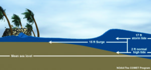
Storm surge heights are cumulatively based on the mean sea level, the height of the tide, and the high volume of water pushed toward the shore by coastal storms (National Hurricane Center). Reuse courtesy of APA.

It is natural that a planning document is going to assert a role for planners in addressing these problems. The role the report asserts is entirely logical, starting with “assessing long-term infrastructure needs and understanding future risks to infrastructure assets.” Equally logical, however, is that the report builds upon prior APA literature to outline the need for coordinated action through the plan-making process to integrate climate risk into local plans as a means of “capturing the future conditions to which existing infrastructure and any planned infrastructure projects will be subjected.” Put simply, if the local planning process does not identify those risks and provide clear recommendations for creating resilient infrastructure, it is not likely to materialize in any coherent and consistent fashion. The third chapter outlines a step-by-step approach (see illustrations below) for developing an inventory of local infrastructure, identifying risks, and moving toward an effective plan for adaptation.

The process for conducting an infrastructure vulnerability assessment (Joseph DeAngelis). Reuse courtesy of APA for both diagrams.


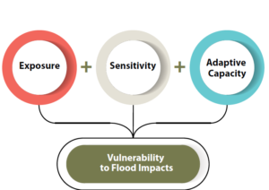
A project or asset’s vulnerability to flood impacts is a product of its exposure, sensitivity, and adaptive capacity (Joseph DeAngelis).

Later, the report provides some examples of what such consistent planning for resilient infrastructure may look like. Its case study of San Francisco’s approach to assessing sea-level-rise impacts outlines how the Sea Level Rise Committee of the city’s Capital Planning Committee (CPC), a body responsible for overseeing capital investments for infrastructure, recommended using the upper end of estimates from a National Research Council report for the West Coast. These were fed into a CPC guidance document for assessing vulnerability and supporting adaptation to sea level rise, a primary outcome of climate change. Without engaging the full details here, the bottom line is that the City and County of San Francisco was working from a single play book for climate adaptation of project life cycles for future infrastructure. Capital planning could thus proceed in a more standardized manner based on common assumptions. The report also uses an extensive example from Toledo, Ohio, the site of one of two pilot projects supported by the ASFPM/APA project. Toledo, sitting on the shores of Lake Erie, has suffered from stormwater flooding and is approaching the problem with a mixture of green infrastructure and analysis of social vulnerability in affected neighborhoods. The report elsewhere delves into questions and methods of documenting and addressing environmental justice and social and racial inequities in environmental protection through appropriate local capital planning projects.

Both cases highlight the value for local planners of establishing credible data sources, which often rest within federal agencies such as NOAA and the U.S. Environmental Protection Agency. But, as one chapter illustrates, these can include experienced national nonprofits as well, such as Climate Central. Unquestionably, however, the best single assemblage of data and tools is NOAA’s own Digital Coast website. Planners can access additional high-quality resources on climate through other NOAA programs such as the Regional Climate Centers, located at a series of universities across the nation, and the Regional Integrated Sciences and Assessments, where RISA staff work directly with climate scientists to communicate the science to the public and local officials.

Just as important as understanding where to find the proper data and tools, however, is a knowledge of best practices in local capital improvements planning, the development of effective standards, guidelines, and regulations for creating resilient infrastructure, and, finally, the best means for financing such long-term investments in infrastructure, especially with an eye to climate resilience. Each of these three topics is covered in separate chapters in the second half of the report.

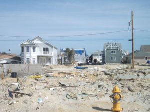
View of part of the Jersey Shore after Hurricane Sandy, February 2013.

Ultimately, the real challenge for local planners is overcoming a natural discomfort with the inherent uncertainties in planning for infrastructure that must withstand the impacts of climate change within a range of assumptions that, in part, depend on federal and even international action to mitigate rising global temperatures as a result of greenhouse gas emissions. Planners, and the communities they serve, must adjust to those uncertainties and the inherent complexities they embody. Planning, however, has always been a speculative enterprise riddled by uncertainties, yet cities have embraced assumptions about population growth, demographic change, and economic scenarios that have often been equally uncertain, for none of us has a crystal ball. What we do know, however, is the direction of existing and accelerating trends, and climate change is no myth. We are ultimately better off, and will better invest public resources, by anticipating climate change with the best projections available, so that our communities are not overwhelmed by future storms, sea level rise, and storm surge. We cannot say we did not see it coming. We can only hope to say we used a wise approach based on the best data available to avoid catastrophe for ourselves and future generations in the communities we serve.

Jim Schwab


The People Affected by Harvey

A few days ago, in my last post, I wrote that Hurricane Harvey would last a few days, but the recovery would last years. However agonizingly long Harvey appears to be taking to inflict its misery on the Texas Gulf Coast, and now parts of southern Louisiana, it will go away. And then the real marathon will begin. People will have to face the necessity of reconstruction, both as individuals and as whole communities.

In writing about this now, I am crediting readers with a longer attention span than seems to be assumed of most Americans on social media today. I truly hope, however, that the news media does not forget about Harvey or the Gulf Coast as the recovery process grinds on over coming months and years. Certainly, most residents of the Texas coast will have little choice but to bear with the process, and ideally, they will participate. Recovery needs to be as participatory as possible to succeed fully.

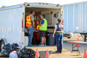
FEMA teams managing the distribution of water, and meals for hundreds of semi-trucks at an incident Support Base in Seguin, Texas. Photo by Dominick Del Vecchio – Aug 29, 2017 (from FEMA website) 

It will not always be a pretty picture. The news media in recent days have been full of photographic and video evidence of the best aspects of humanity—people in boats rescuing neighbors and strangers alike, public safety personnel risking personal safety as they save people from flooded homes and transport them to shelters, and other heroic acts away from cameras and too numerous to count. People from other states and nations will contribute to disaster-related charities to help people they have never known and may never meet. Politics and race and religion will all take a back seat to saving lives and reducing suffering. For just a brief moment in history, we can stop shouting at each other long enough to care for each other and be proud of one another.

Several years ago, Rebecca Solnit produced an intriguing book, A Paradise Built in Hell, that explored many of the positive community-building relationships that emerge when people are challenged by adverse circumstances such as major natural disasters. It is a journalistic journey through the informal alliances and communities created by people under what seemingly are the worst possible conditions, but which challenge our humanity and force us to consider how we value those around us. It is an optimistic book that forces readers to rethink what it means to live through a disaster. I have always hoped that it would spark similar efforts among academic researchers, particularly in the social sciences, to study this phenomenon more closely. I think that is happening to some extent, but perhaps not nearly enough.

The Texas Gulf Coast communities stricken by Harvey will need as much of that spirit as they can muster to produce successful long-term recovery. Recovery takes years because, while no one wants to delay rebuilding unnecessarily, hasty rebuilding that fails to consider the failure points that allowed destruction to occur is even more undesirable. Under considerable time pressures, which researchers Robert Olshansky and Laurie Johnson, both wonderful friends of mine, have notably referred to as the problem of “time compression” in disaster recovery, planners and local and state officials will need to meet with constituents, hear their concerns, explain both the obstacles and opportunities involved in reconstruction, and ideally, inform the public process to help lead to a better outcome. During this time, minor and modest repairs may go forward while the bigger decisions, like where to buy out damaged properties, how to rebuild infrastructure and to what new standards, and how to produce a stronger, more resilient community to handle future disasters may need to undergo vigorous debate.

I point this out because, inevitably, and despite Solnit’s rosy scenarios in the context of community building, tempers will rise and people will need to iron out significant differences and widely varying perceptions of the causes of, and solutions to, the damage that occurred. There will surely be some debate about Houston’s sprawling development patterns and relative lack of development controls. There may be debates about strengthening building or zoning codes or, in Houston, the absence of zoning. If there is any echo of Hurricane Sandy, there may be discussion of a greater role for green infrastructure in mitigating hazards, though that alone would have made only modest difference in the flooding from Harvey, but it might have helped.

More importantly, people will have undergone trauma that will make them deeply and justifiably emotional about the disruption of their lives. They will bring that trauma, and a need to vent and share their fears and anger, to public meetings. Public officials will need to exhibit patience because, as Christine Butterfield, another good friend who served as community development director in Cedar Rapids, Iowa, during and after the 2008 floods, has noted, those public gatherings will be therapeutic. People may cry, they may yell, they may accuse. Most of all, they need to know that someone else wants to hear and share their pain. They want to know that someone cares. Once most have achieved that comfort level, they may be ready to move forward and discuss options for recovery. But first, community leaders must build trust.

Some people may never trust, and the rest of the community may need to move on. Life is not perfect. Human beings are not perfect. Recovery cannot wait forever, but it must demonstrate compassion and a commitment to social equity.

In a few weeks, the entire process will begin, and people will decide what role they want to play. Leaders will arise in unexpected places. Just last week, my students at the University of Iowa School or Urban and Regional Planning, during a field trip with which I launch my course on “Planning for Disaster Mitigation and Recovery” every year, heard from United Methodist pastor Clint Twedt-Ball, a co-founder and executive director of Matthew 25, a community organization that arose from almost nothing after the 2008 floods in Cedar Rapids to help rebuild 25 blocks of downtrodden neighborhoods in the city, raising money but also making tough decisions about what would work and what would not. Nine years later, his organization is still working to make a difference. Before 2008, Clint would confess, he knew next to nothing about floods or community development. My guess is that now he could nearly write a book. Who knew?

Watch Houston, and Rockport, and Corpus Christi, and all the other cities on the Texas Gulf Coast for both surprises and struggles, and mostly for deep human engagement in solving massive redevelopment problems the likes of which most of us will never have to confront. And be ready to cheer them on when good things happen. They are likely to need the encouragement from time to time.

Jim Schwab

Natural Solutions for Natural Hazards

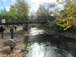
Boulder Creek, Boulder, Colorado

Boulder Creek, Boulder, Colorado

It has taken a long while in our modern society for the notion to take hold that some of the best solutions to reduce the impact of natural hazards can be found in nature itself. Perhaps it is the high cost of continuing to use highly engineered solutions to protect development that has often been sited unwisely in the first place that has finally gotten our attention. Particularly after Hurricane Sandy, however, the notion of using green infrastructure as part of the hazard mitigation strategy for post-disaster recovery began to gain traction; green infrastructure was highlighted in the federal Hurricane Sandy Rebuilding Strategy. These approaches are also known as natural or nature-based designs. They involve understanding the role natural systems play in reducing damages and in using that knowledge to deploy such solutions as part of an intelligent game plan for improving community resilience.

But where should community planners and local officials get reliable information on the best and most proven strategies for implementing green infrastructure solutions?

About a year and a half ago, researchers from The Nature Conservancy (TNC) approached me about involving the American Planning Association (APA) Hazards Planning Center in a project they were undertaking with support from the Kresge Foundation to prepare such information in the form of a green infrastructure siting guide. In the end, they also involved the Association of State Floodplain Managers (ASFPM), the National Association of Counties (NACo), the American Society of Civil Engineers, and the Boston-based design firm Sasaki Associates to assist with this effort. Over the past year or more, we have all met regularly to discuss what needed to be done and our progress in making it happen. We produced case studies, strategy briefs, and other material to populate the project’s web-based resources.

Bioswale in a subdivision development in Boulder County, Colorado.

Bioswale in a subdivision development in Boulder County, Colorado.

Last month, after all that teamwork, TNC unveiled its new website for the project, called Naturally Resilient Communities. For those interested in knowing how trees, living shorelines, dunes, coastal marshes, and oyster reefs, among other types of natural infrastructure, can help mitigate natural hazards like coastal storms and urban flooding, the website provides a serious and interactive introduction to the subject matter, backed up by numerous resources.

What is especially valuable about the website design is that it allows users multiple avenues into the specific types of information they need. Not all natural infrastructure solutions are born equal. Some are more appropriate in certain settings than others. Some work best in inland river valleys, some along coastlines, and others in mountains or high plains. Some coastal solutions work well in the rocky coastlines of California or Oregon, while others work better along Atlantic or Gulf Coast shorelines. Applying such solutions is largely a matter of learning what works best in a specific natural environment in the face of specific hazards—riverine flooding, hurricanes, thunderstorms, or other threats that communities face. It is critical to adapt the solution to the problem.

Accordingly, the website, largely the work of Sasaki Associates with vetting from the other project partners, allows users to approach the information by deciding which strategies they wish to investigate or which part of the United States is relevant. They can also look at considerations such as cost, the geographic scale of the solution (neighborhood, municipal, regional), and the type of community in question. These are precisely the frames of reference familiar to most urban planners and civil engineers who are most likely to be involved in implementing natural infrastructure projects. The emphasis throughout is on the practical, not the ideal or the ideological. A particular approach either works or does not work, but it does so in very specific settings, such as a neighborhood in a city along one of the Great Lakes or in the Southwestern desert. Context is the central question.

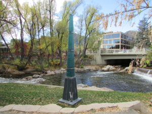
This memorial to Gilbert White, the pioneer of modern floodplain management, marks the high point of flooding along Boulder Creek.

This memorial to Gilbert White, the pioneer of modern floodplain management, marks the high point of flooding along Boulder Creek.

Establishing context is why the project put considerable emphasis on case studies, which cover a variety of communities around the nation. Specify, for example, Rocky Mountain West as a region and riverine flooding as a problem, and the site gives you a case study from Boulder, Colorado, that examines the alternatives considered and solutions adopted for flooding along Boulder Creek and discusses the involvement of the city and the Denver-based Urban Drainage and Flood Control District to implement a stream restoration master plan. One can also find case studies from Florida, Ohio, and numerous other locations. One can also, however, explore sections of the website devoted to additional resources and funding

sources to support green infrastructure projects. These allow the user to connect to other websites and some PDFs for additional information.

Go explore. I admit to taking pride in our involvement in this effort. It is, I think, a welcome resource and great learning tool for planners, engineers, local officials, and the interested public.


Jim Schwab

Making Natural Infrastructure Solutions Happen

From time to time, I contribute to the APA Blog, which consists of a variety of news and perspectives the American Planning Association provides to its members on its own website. Recently, I composed an article about an effort APA undertook in concert with several organizational partners to explore issues related to permitting of wetlands restoration projects and some of the obstacles such projects may face. For those interested, just follow the link: https://www.planning.org/blog/blogpost/9118459/.

Jim Schwab

Regional Green Infrastructure

The subtitle to this headline for many people might be: Who Cares? As a term of art, green infrastructure may be popular with landscape architects, civil engineers, and urban planners, among a few other allied professions, but it does not often mean much to the average person. Many people may struggle to define infrastructure even without the word green in front of it.

Infrastructure generally refers to those modern systems, such as roads, bridges, and utility grids that allow our cities and regions to function effectively. Recognizing that the value of infrastructure lies in the services it provides, green infrastructure has been distinguished from traditional gray infrastructure by focusing on the use of natural systems, such as wetlands and urban forests, to protect or enhance environmental quality by filtering air pollution, mitigating stormwater runoff, and reducing flooding. It stands to reason that such natural systems are most likely to provide such “ecosystem services” well when we respect and preserve their natural integrity. It also stands to reason that, to the degree that such systems face threats from urban sprawl and urbanization, their ability to perform those services for human populations is diminished. To say that development has often helped to kill the goose that laid the environmental golden egg is to state the obvious, no matter how many people want to avoid that truth. That does not mean that our cities cannot or should not grow and develop. It does mean that, using the best available natural science, we need to get much smarter about how it happens if we want to live in healthy communities.

Fiscalini Ranch Preserve in Cambria, California.

Fiscalini Ranch Preserve in Cambria, California.

I mention this because, as part of the American Planning Association staff pursuing such issues, I spent three days in Washington, D.C., last week at a symposium we hosted with U.S. Forest Service sponsorship on “Regional Green Infrastructure at the Landscape Scale.” We were joined by about two dozen seasoned experts not only from the Forest Service and APA, but from the U.S. Environmental Protection Agency, several national nonprofits, and others to sort through the issues impeding better planning for green infrastructure. We explored major hazard-related issues such as wildfires, flooding, and coastal storms and how green infrastructure can or should function in relation to them.

This matters because there are huge costs associated with the way we choose to develop. There can also be huge benefits. Whether the ultimate ledger in any particular region is positive or negative is largely dependent on the approach we choose, and that is heavily dependent on how broadly or narrowly we view our responsibilities. Historically, in America, we have been rather myopic about the damage we have done to our environment, but our perspective has become more comprehensive over time, starting with the conservation movement in the late 1800s. But today, as always, there are undercurrents of more myopic attitudes and impatience with the more deliberate and thoughtful calculations a more long-term view requires. There is also the simple fact that understanding issues like climate change requires some degree of scientific literacy, something that is missing too often even in some presidential candidates.

But it helps to drill down to specific situations to get a firm sense of consequences. For instance, the Forest Service budget is literally (and figuratively) being burned away by the steadily and rapidly increasing costs of fighting wildfires. That is in large part because the average annual number of acres burned has essentially tripled since 1990, from under 2 million then to about 6 million now. As recently as 1995, 16 percent of the agency’s budget went to suppressing wildfires. Every dollar spent on wildfires is a dollar removed from more long-term programs like conservation and forest management. By 2015, this figure has risen to 52 percent, and is projected to consume two-thirds of the agency’s budget by 2025. Clearly, something has to give in this situation, and in the present political situation, it is unlikely to be an expansion of the Forest Service budget. At some point, a reckoning with the causes of this problem will have to occur.

What are those causes? Quite simply, one is a huge expansion in the number of homes built in what is known as the wildland-urban interface (WUI), defined as those areas where development is either mixed into, interfaces with, or surrounds forest areas that are vulnerable to wildfire. The problem with this is that every new home in the WUI complicates the firefighters’ task, putting growing numbers of these brave professionals at risk. Every year, a number of them lose their lives trying to protect people and property. In an area without such development, wildfires can do what they have done for millennia prior to human settlement—burn themselves out. Instead, a century of aggressive fire suppression has allowed western forests, in particular, to become denser and thus prone to more intense fires than used to occur. The homes themselves actually represent far greater densities of combustible material than the forest itself; thus fires burning homes are exacerbated by increased fuel loads. In addition, prescribed fire, a technique used to reduce underbrush in order to reduce fire intensity, becomes more difficult in proximity to extensive residential development. A prescribed fire that spun out of control was the cause of the infamous Los Alamos, New Mexico, wildfire in 2000. The entire situation becomes highly problematic without strong political leadership toward solutions.

At the same time, denial of climate change or even reluctance to broach the subject does not help, either. It compounds the difficulty of conducting an informed dialogue at a time when increased heat and drought are likely to fuel even more wildfires of greater intensity. The recent major wildfire around Fort McMurray, Alberta, displacing thousands of people, may be a harbinger of things to come.

That is just one sample of the issues we need to confront through a larger lens on the value of large-scale green infrastructure and regional cooperation to achieve positive environmental results that also affect issues like water quality and downstream flooding. Because we could produce an entire book on this issue—and the suggestion has in fact been made that we do so—I will not even attempt here to lay out the entire thesis. Rather, it may be useful to point readers to some resources that I have found useful in recent weeks in the context of writing for another project on green infrastructure strategies. Most of these are relatively brief reports rather than full-length books, enough to give most readers access to the basics, as well as references to longer works for those so inclined.

On the subject of water and development in private forests, a Forests on the Edge report, Private Forests, Housing Growth, and Water Supply is a good starting point for discussion. Because planning to achieve effective conservation at a landscape scale requires collaboration among numerous partners, an older (2006) Forest Service report, Cooperating Across Boundaries: Partnerships to Conserve Open Space in Rural America, may also be useful. With regard to wildfires, a recent presentation at a White House event by Ray Rasker, executive director of Headwaters Economics, a firm that has specialized in this area, may also be useful for its laser focus on trends and solutions with regard to development in the wildland-urban interface and the need for effective, knowledgeable local planning in areas affected by the problem. But I would be remiss if I did not bring readers’ attention back to a 2005 APA product of which I was co-author with Stuart Meck: Planning for Wildfires. It could probably use some updating by now, but every one of our central points, I believe, remains valid.

Happy reading to all!


Jim Schwab