Filming on the Texas Gulf Coast

It has been a couple of months since I last posted a video of our progress in filming for Planning to Turn the Tide. That last article summarized our film efforts in Jacksonville, Florida, in September 2023, but we had another trip in the offing then, to the Texas Gulf Coast. In between, as noted in a January 1 post, I underwent prostate surgery on September 29, which required at least a month of rest and inactivity at home before venturing out again, in order to ensure successful recovery. But on November 7, I met up with videographer David Taylor at Houston Hobby Airport and we drove to Corpus Christi, where the annual conference of the Texas Chapter of the American Planning Association was getting underway. The new blog video presented here was filmed there but edited and produced later.

Devastation in the Bolivar Peninsula from Hurricane Ike, 2009

Despite my own challenges, what compelled this schedule was that conference at the American Bank Center in Corpus Christi because it allowed us to interview eight Texas planners who have been prominently involved in efforts to confront and address resilience issues along the Gulf Coast, where coastal storms and flooding remain major concerns. Hurricane Harvey, which struck in the fall of 2017, may be the most famous, and famously expensive, disaster of recent history in the area but is certainly not unique. People with a longer memory can cite Tropical Storm Allison, which struck Houston in 2001, and Hurricane Ike, which devastated Galveston in 2008, as part of the long parade of such events.

It is easy enough to cite shortcomings of the past that made destruction in such storms worse than it needed to be, but it is also important to note the resources that Texas has created to tackle those problems, including Texas Target Communities, a program at Texas A&M University that aids resource-challenged communities. These groups were present at the Texas APA conference, and we interviewed both Jaimie Masterson, the director of Texas Target Communities, and Shannon Van Zandt, a professor of urban planning at the Texas A&M School of Architecture, who has long researched and advocated for better affordable housing solutions in disaster recovery.

Tornado impacts in Van Zandt County, Texas, April 2017. Seven tornadoes struck the area in one evening.

I should also note that disaster resilience has been a consistent theme of the Texas Chapter. Back in November 2017, I spent time in Texas at the behest of the chapter, which asked me to facilitate and keynote a recovery workshop in Canton, Texas, following a series of tornadoes there, but I also worked with their Harvey Recovery Task Force well into 2020. The film trip grew out of that partnership, which extends even further back to my speaking at chapter conferences in El Paso and Galveston after Hurricane Ike. We want to thank the Texas Chapter for their logistical and promotional support during the conference.

Peer exchange workshop in Rockport, February 2020, involving Harvey and Sandy recovery planners. Kim Mickelson, of Houston, with microphone, is moderating this session.

Following our time in Corpus Christi, we drove up the coast to Rockport, the site of the first landfall of Hurricane Harvey, where we interviewed four community leaders, including a city council member, the local newspaper editor, the public works director, and a former president of the local chamber of commerce, about Rockport’s experience in recovery. I have learned a great deal in recent years about Rockport, in large part because of my work with Amanda Torres, the former city planner there, now working for the Corpus Christi Planning Department, and Carol Barrett, a veteran planner now living in Austin, who led APA’s Community Planning Assistance Team in Rockport in 2019. They helped me design the Rockport case study for an interactive workshop, including both graduate students and practicing planners, that is part of a course I teach for the University of Iowa School of Planning and Public Affairs.

We ended our trip in Houston, which included a tour of largely Hispanic neighborhoods in the shadow of the city’s huge petrochemical complexes, where they face ongoing racially disparate environmental impacts. We were hosted on that tour by TEJAS Barrios, a local environmental justice advocacy group. We hope to return to Houston, but our challenge for now is to raise substantial money to try to complete the film project in the coming year. Fortunately, our core team has grown, with more hands on deck focused on fundraising. If you are willing to help, you can donate here or use the QR code below to contribute online at the APA website.


Jim Schwab

Romping through South Florida

Two weeks ago, I spun a narrative about hazard mitigation in Hillsborough County, Florida, based on both prior knowledge and a personal tour conducted by long-time colleague Eugene Henry. Today, a full month or more after that visit, I add notes about touring the Sarasota area with my personal friend and high school classmate, David Taylor.  David is a Vietnam veteran and professional photographer who was part of the Brecksville (Ohio) High School class of 1968. Yes, we graduated in the middle of it all in the late 1960s.

Unlike me, David was drafted into the army. I maintained a student deferment initially, then went untouched by the draft lottery, which reached 125 the year I surrendered my deferment. Numbers were based on the number pulled for your birth date. Mine was 135. Such was the luck of the draw in those days. In less than two months on the ground in Vietnam, David was badly injured in a mortar explosion, evacuated to a hospital and sent home. His injuries were more than severe enough to terminate his service. He spent months in rehab. When it became clear that cold weather aggravated his disabilities, he moved to Florida. He has lived there ever since. He and his wife, Linda, now live in a small home in a subdivision near the water in Sarasota.

His long tenure in Florida has allowed him ample time to learn the sights and sounds of his adopted home. One thing my wife and I learned from staying with him for five days is that Dave is relentlessly curious. He attended and videotaped my February 22 lecture for Florida Atlantic University in West Palm Beach, then loaded the 37-gb high-res recording on a flash drive. Download it to your laptop when you get back, then reload the flash drive with as many documents and photos about your work as will fit on it, he told me.

I don’t think Dave completely understood. I could give him nearly everything I have and never fill up a drive of that size. But Dave lives in the film world, and all the reports I have downloaded as PDFs and all the still photos I have ever taken will never equal more than a fraction of that memory. I gave him all I could.

More importantly, however, Dave took us on some tours to take maximum advantage of the two days we had remaining after returning from West Palm Beach (a 3 ½-hour drive across the southern interior of Florida). From an environmental standpoint, it is important to know that Florida is a more diverse state than outsiders may realize and that, due to rapid urbanization in the past few decades, it also faces environmental challenges and threats of significant proportions. The state has been wrestling with many of these for a long time. The fate of the Everglades triggered one of the most notable environmental policy battles in American history, but there are many smaller issues as well, many engendering serious public health concerns as well.

One to which Dave took us, new to me, was the American Beryllium site on Tallevast Road in Sarasota. Now abandoned, the site hosted a manufacturing facility for machine parts of the Loral Corporation, parent company of American Beryllium, for more than 30 years until 1996. The operations created beryllium dust that contaminated the soil and groundwater. Lockheed Martin acquired the plant in 1996 and closed it down. Subsequent investigations discovered the contamination and documented the need for cleanup of what was then a brownfield site. By 2008, the Agency for Toxic Substances and Disease Registry (ATSDR) of the U.S. Department of Health and Human Services completed its own assessment of the health risks, concluding that, while there was a wide margin of possibilities given the combination of contaminants including trichloroethylene in the beryllium-containing metals on the site, there was a definite public health hazard. Previous use of groundwater by local residents and employees, which by then had ceased, posed a credible risk of kidney cancer, liver cancer, leukemia, and lymphoma. By 2004, all nearby residents had been using municipal water, but the long-term legacy could not be ignored.

Fence provides no real security for American Beryllium site.

The site today is mostly an empty lot next to a golf course. There is a fence around it that, frankly, is not well maintained, but how much danger the site poses at this point, I do not know. The empty lot looks rather forlorn, yet the area around it contains a fair amount of operative commerce. When, if ever, the site will be ready for reuse remains to be seen. Mostly, it is a sobering reminder of our past use and misuse of such toxic materials in manufacturing processes and the problems they often leave behind. Beryllium is a divalent element, a strong metal with high thermal stability that is useful in aerospace applications, certainly of interest to a firm like Lockheed Martin. But often in the past, manufacturing firms took inadequate measures to prevent the sort of pollution that materialized on this site. The result is a long-standing eyesore for Sarasota.

But there were other things to see in the area, like Myakka River State Park, which features a wildlife preserve that is worth visiting and attracts many visitors. Park officials are often available to explain the wildlife you are seeing, such as snowy egrets, cypress trees, vultures, and, of course, alligators. The vultures seemed exceptionally calm and contented, so Dave and I concluded that they had already had their fill for the day.

Vultures line the shore of the river.

Unable to stop myself—we have a growing collection of souvenir mugs in our cupboards—I bought a reasonably priced mug from the gift shop with the state park logo embedded in the ceramic. Our children one day, when we are no longer breathing, may wonder “Myakka what?” and pass it on to the nearest Salvation Army store, but we will enjoy it for the next 20 years, or until one of us accidentally drops it on the floor (whichever comes first). Who knows when we will be back?

David has vivid memories of his Vietnam experiences, and to some extent, like most Purple Heart veterans, of the trauma involved in his experience. This remains no small part of his semi-retired life, in which he is also enrolled in film and history classes at nearby State College of Florida, and continues part-time photographic work. So, he took us to the Sarasota National Cemetery, where veterans may choose to be buried, and where he has attended and participated in numerous ceremonies. Kiosks exhibit photos documenting the veteran experience as far back as World War I but as recent as Afghanistan. The growing Florida population including the elderly means a growing number of veterans for whom the cemetery may be a final resting place. It is always a sobering encounter with reality to visit such a place—to realize how many lives are affected, for good or ill, by the nation’s struggles throughout our history. One does not have to agree with a particular war, and I have certainly disagreed with some, to recognize the magnitude of the sacrifice of those in uniform and the respect they deserve. Just gazing out at a wide field of gravesites should be enough to convey the message. War is no trifling thing. We invariably owe our veterans a serious explanation when we send them into battle.

On that Saturday evening, however, it was time for fun, and Dave and Linda took us to a comedy club, McCurdy’s Comedy Theater and Humor Institute, which was great fun, and on the way back to their home, we stopped at the “Kissing Sailor” statue, developed from an iconic photo of a sailor embracing his beloved on the streets of Manhattan as the official surrender of Japan and the end of World War II were announced. Each couple shot photos of the other standing beneath this unique feature of the urban landscape in Sarasota.

Dave and Linda beneath the Kissing Sailor.

The next morning, with our free time waning before driving to the Tampa International Airport, we all made one last stop, at the Ken Thompson Park. What would Florida be without its beaches? Ken Thompson, the namesake of the park, was a long-time city manager in Sarasota. More importantly, the beach, like the rest of southern Florida, was 84° F. and sunny, with plenty of people resting on the sand and taking in the scenery of the Gulf Coast. Not far away are opportunities to follow a boardwalk through a small forest. It is small wonder in such a setting that Florida might beckon to anyone used to northern weather in the winter, but duty called, and Chicago is very nice once spring arrives.


In fact, I took so long to write this story that it is here. Tomorrow I plan to take time to ride my bicycle on the 606 Trail, whose story I told in this blog when it opened nearly four years ago. Snow? It happens, but it’s over for now, just a fading memory.

Jim Schwab

The People Affected by Harvey

A few days ago, in my last post, I wrote that Hurricane Harvey would last a few days, but the recovery would last years. However agonizingly long Harvey appears to be taking to inflict its misery on the Texas Gulf Coast, and now parts of southern Louisiana, it will go away. And then the real marathon will begin. People will have to face the necessity of reconstruction, both as individuals and as whole communities.

In writing about this now, I am crediting readers with a longer attention span than seems to be assumed of most Americans on social media today. I truly hope, however, that the news media does not forget about Harvey or the Gulf Coast as the recovery process grinds on over coming months and years. Certainly, most residents of the Texas coast will have little choice but to bear with the process, and ideally, they will participate. Recovery needs to be as participatory as possible to succeed fully.

FEMA teams managing the distribution of water, and meals for hundreds of semi-trucks at an incident Support Base in Seguin, Texas. Photo by Dominick Del Vecchio – Aug 29, 2017 (from FEMA website) 

It will not always be a pretty picture. The news media in recent days have been full of photographic and video evidence of the best aspects of humanity—people in boats rescuing neighbors and strangers alike, public safety personnel risking personal safety as they save people from flooded homes and transport them to shelters, and other heroic acts away from cameras and too numerous to count. People from other states and nations will contribute to disaster-related charities to help people they have never known and may never meet. Politics and race and religion will all take a back seat to saving lives and reducing suffering. For just a brief moment in history, we can stop shouting at each other long enough to care for each other and be proud of one another.

Several years ago, Rebecca Solnit produced an intriguing book, A Paradise Built in Hell, that explored many of the positive community-building relationships that emerge when people are challenged by adverse circumstances such as major natural disasters. It is a journalistic journey through the informal alliances and communities created by people under what seemingly are the worst possible conditions, but which challenge our humanity and force us to consider how we value those around us. It is an optimistic book that forces readers to rethink what it means to live through a disaster. I have always hoped that it would spark similar efforts among academic researchers, particularly in the social sciences, to study this phenomenon more closely. I think that is happening to some extent, but perhaps not nearly enough.

The Texas Gulf Coast communities stricken by Harvey will need as much of that spirit as they can muster to produce successful long-term recovery. Recovery takes years because, while no one wants to delay rebuilding unnecessarily, hasty rebuilding that fails to consider the failure points that allowed destruction to occur is even more undesirable. Under considerable time pressures, which researchers Robert Olshansky and Laurie Johnson, both wonderful friends of mine, have notably referred to as the problem of “time compression” in disaster recovery, planners and local and state officials will need to meet with constituents, hear their concerns, explain both the obstacles and opportunities involved in reconstruction, and ideally, inform the public process to help lead to a better outcome. During this time, minor and modest repairs may go forward while the bigger decisions, like where to buy out damaged properties, how to rebuild infrastructure and to what new standards, and how to produce a stronger, more resilient community to handle future disasters may need to undergo vigorous debate.

I point this out because, inevitably, and despite Solnit’s rosy scenarios in the context of community building, tempers will rise and people will need to iron out significant differences and widely varying perceptions of the causes of, and solutions to, the damage that occurred. There will surely be some debate about Houston’s sprawling development patterns and relative lack of development controls. There may be debates about strengthening building or zoning codes or, in Houston, the absence of zoning. If there is any echo of Hurricane Sandy, there may be discussion of a greater role for green infrastructure in mitigating hazards, though that alone would have made only modest difference in the flooding from Harvey, but it might have helped.

More importantly, people will have undergone trauma that will make them deeply and justifiably emotional about the disruption of their lives. They will bring that trauma, and a need to vent and share their fears and anger, to public meetings. Public officials will need to exhibit patience because, as Christine Butterfield, another good friend who served as community development director in Cedar Rapids, Iowa, during and after the 2008 floods, has noted, those public gatherings will be therapeutic. People may cry, they may yell, they may accuse. Most of all, they need to know that someone else wants to hear and share their pain. They want to know that someone cares. Once most have achieved that comfort level, they may be ready to move forward and discuss options for recovery. But first, community leaders must build trust.

Some people may never trust, and the rest of the community may need to move on. Life is not perfect. Human beings are not perfect. Recovery cannot wait forever, but it must demonstrate compassion and a commitment to social equity.

In a few weeks, the entire process will begin, and people will decide what role they want to play. Leaders will arise in unexpected places. Just last week, my students at the University of Iowa School or Urban and Regional Planning, during a field trip with which I launch my course on “Planning for Disaster Mitigation and Recovery” every year, heard from United Methodist pastor Clint Twedt-Ball, a co-founder and executive director of Matthew 25, a community organization that arose from almost nothing after the 2008 floods in Cedar Rapids to help rebuild 25 blocks of downtrodden neighborhoods in the city, raising money but also making tough decisions about what would work and what would not. Nine years later, his organization is still working to make a difference. Before 2008, Clint would confess, he knew next to nothing about floods or community development. My guess is that now he could nearly write a book. Who knew?

Watch Houston, and Rockport, and Corpus Christi, and all the other cities on the Texas Gulf Coast for both surprises and struggles, and mostly for deep human engagement in solving massive redevelopment problems the likes of which most of us will never have to confront. And be ready to cheer them on when good things happen. They are likely to need the encouragement from time to time.

Jim Schwab

Initial Observations on Harvey

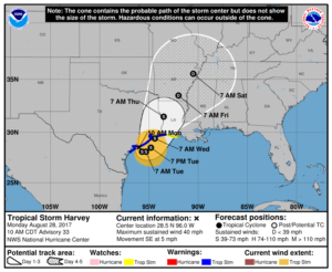
Map from National Weather Service. http://www.weather.gov/akq/Harvey

For the people of the Texas Gulf Coast, the rain and winds of Hurricane Harvey are just the beginning of a long journey. The storm will last a few days. The recovery will last years.

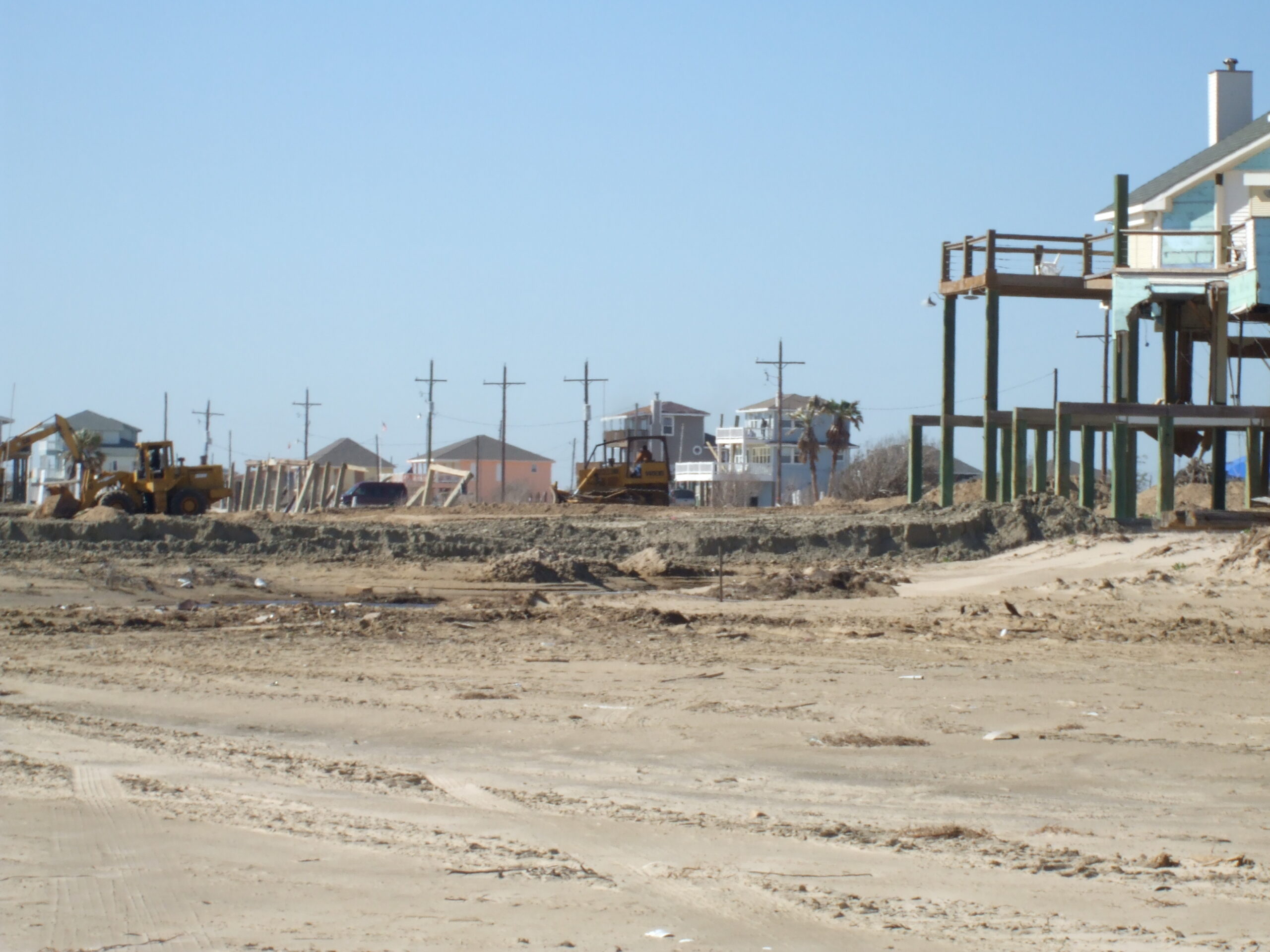
Destruction in the Bolivar Peninsula after Hurricane Ike in 2008

I am not there, so I can only surmise, based on the news coverage I have seen, the full extent of the damage and suffering that people are enduring in Corpus Christi, Houston, Galveston, and hundreds of other communities in a wide arc that has fallen under the impact of this storm. I do not even expect that people there will read this, certainly not right now. Nonetheless, it may be worthwhile to offer some insights to people elsewhere. I have never lived or worked in Texas, but I have been there numerous times and visited Louisiana more often than I can remember. I saw first-hand the devastation wrought in the Bolivar Peninsula and Galveston after Hurricane Ike. I have worked with people in Texas, including those at the Texas A&M Hazards Reduction and Recovery Center, over many years. They have educated me greatly on the vulnerabilities of their state.

With all due humility, therefore, but also with experience from other disasters over the past quarter-century, I offer some observations that may enhance what readers of this blog may learn from the news.

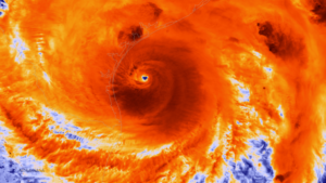
Photo from NOAA. The NOAA/NASA Suomi NPP satellite captured this infrared image of Hurricane Harvey just prior to making landfall along the Texas coast on August 25, 2017 at 18:55 UTC. NOAA’s National Hurricane Center has clocked Harvey’s maximum sustained winds at 110 miles per hour with higher gusts. Infrared images like this one can help meteorologists identify the areas of the greatest intensity within large storm systems, such as the areas with the most intense convection, known as overshooting cloud tops (dark orange), surrounding the eye and along the outer bands. https://www.nnvl.noaa.gov/MediaDetail2.php?MediaID=2086&MediaTypeID=1

First, this is apparently a somewhat unusual storm system. It approached the coast just northeast of Corpus Christi as a Category 4 hurricane, although it is now downgraded to a tropical storm. That does not make it less dangerous. The Saffir-Simpson scale that is used to rate hurricane strength deals only with wind speeds. Winds are certainly important, especially when they reach the 130 mile-per-hour range that was the peak for this event. Winds have, from all the visual evidence on the various news outlets I have watched, wreaked tremendous havoc along the coast, tearing apart buildings and overturning trailers and other vehicles. Moreover, hurricanes often spawn tornadoes, and some of the intermittent damage—that is, buildings ripped apart near others largely intact—suggests that this has occurred. In other words, if the more diffuse hurricane winds don’t get you, the tornado just might. It is no laughing matter. It is a wonder the death toll remains relatively low, although we almost surely don’t know the full tally just yet.

One specific impact that always accompanies coastal storms of this magnitude is storm surge, the waters pushed landward by the winds that in this case ranged from six  to twelve feet. These can do considerable damage in low-lying areas along the coast and may also exacerbate coastal erosion.

What makes the storm somewhat unusual also makes it dangerous even after being downgraded to a tropical storm. The storm system appears to have stalled a bit on Sunday and may even be backing out into the gulf for another landfall. At least two very serious consequences can flow from this. One is that the stagnant storm front will dump immense amounts of rain over consecutive days. The projected precipitation totals, even larger than what has fallen so far, mount up, so that projections for many communities range as high as 50 inches. Keep in mind that 30 inches is ample rainfall for an entire year in many parts of the country, and almost no city in the United States is prepared to absorb even half that amount in just a few days. The average yearly rainfall in Houston is just shy of 50 inches.

Moreover, as the storm moves back out over the Gulf of Mexico, it may regain strength that storms typically lose as they make landfall. Tropical storms draw their strength from the warmth of the water over which they pass until they make landfall, after which wind speeds begin to die down. The water of the Gulf right now is in the mid- to high 80s Fahrenheit, reportedly a full two to three degrees above average. That is the source of the strength of Harvey. Regaining any strength from the warm Gulf waters is not a good omen for the Texas coast, and as the storm moves slowly northeast, more of this will affect Houston than was originally the case. That is why we are seeing such intense scenes of flooding in Houston: The storm began with enormous amounts of moisture and has moved along the coast at a snail’s pace, at times just a mile an hour. As the week progresses, however, the storm is projected to move northeast over Louisiana and Arkansas, weakening along the way.

Of course, those warm waters raise questions about the influence of global warming, a topic that does not always receive a warm reception in Texas political circles. It is impossible to say that a specific storm like Harvey would not have happened but for climate change. It is also possible to say very credibly that warmer waters make stronger storms possible. Warmer waters can reflect seasonal and yearly variations, but over time they can also reflect climatic trends. For now, let’s leave it at that. People will have plenty of time later to debate this topic. In due course, as recovery proceeds, it should become a topic of reasonable, informed public discourse.

Other factors are at work as well. The sheer extent of flooding reflects the inexorable fact that the ground in any area has limited capacity to absorb rain. The hydrological cycle allows much rain under normal circumstances to drain into the ground, depending on the types of soil present in any given location. Sand absorbs very well but does not provide a very solid building foundation. Clay provides a better foundation but does not absorb water as quickly. Soil types matter, therefore, but in urban areas we have complicated matters greatly with large quantities of impervious surface that absorb little or no water by design. Impervious surface includes buildings (with the limited exception of green roofs), paved surfaces like roads, parking lots, and driveways, and other structural impediments to the movement and absorption of water. Houston is a very large metropolitan area with the fourth-largest population among major cities in the U.S. Although it is making strides, it is also far from the greenest city in America. Like most major cities, the percentage of impervious surface varies widely, depending on density levels in specific neighborhoods and corridors. Flooding is also influenced by the quality of the drainage systems; Houston is challenged in this respect by low-lying, flat terrain. It is criss-crossed with numerous bayous and canals that provide paths for the movement of water but also have serious limits to the water they can absorb before spilling over onto streets and highways. Those water-filled streets are the main obstacle to evacuation for those who stayed behind. There comes a point where people are better off remaining in place than trying to move, which is why Houston Mayor Sylvester Turner chose not to recommend evacuation.

Some dangers of mass evacuation for 6.5 million people are self-evident: clogged highways that are rapidly filling with water, producing death traps for people in stranded vehicles. Pedestrians cannot see steep drop-offs in elevation as they wade through high waters and can trip and drown. In Houston, the bayous may also contain alligators, water moccasins, and other wildlife hazards that are more easily avoided in dry weather. Moreover, the sheer volume of water can produce eddies and swirls that catch people off guard, and not everyone will be strong enough to regain their footing. Finally, flood water is always dirty water, sometimes just plain filthy, posing a potentially serious threat to public health.

All that said, many other major cities suffer from similar problems. I can think of no city that is prepared for the sheer volume of water currently falling along the Texas coast.

The Texas Gulf Coast communities, therefore, will emerge from this storm with a widespread pattern of both wind- and flood-related damage that will vary significantly from one area to the next, but collectively the costs will probably skyrocket into tens of billions of dollars. It is impossible to know the full costs just yet, but this will almost surely rank as one of the most expensive disasters in U.S. history. The recovery will take years of planning and implementation. If done well, it will involve a great deal of reassessment of patterns of development along the Gulf Coast and of the quality and importance of building codes. Social equity considerations will demand a new examination of the location and quality of low-income housing and the adequacy of affordable housing. Development regulations have seldom been politically popular in Texas, a state that still has never empowered counties to enact zoning codes. Some coastal communities may also wish to look more closely at the prospect of undergrounding utility lines to protect them from hurricane winds.

Events can push public attitudes in new directions. Part of that may depend on new lines of thought gaining traction in the discussion of rebuilding after the disaster. That may require some degree of courageous political leadership. Some very significant changes occurred in Louisiana after Hurricane Katrina, including consolidation of levee district management, adoption of a statewide building code, and a charter amendment in New Orleans that gave a new master plan more control over development regulations. We should not make perverse assumptions about outcomes, just as we also should not be naïve about the obstacles. But in my time at the helm of the Hazards Planning Center of the American Planning Association, we certainly worked hard to create a thorough blueprint for those willing to advocate better planning in response to major and catastrophic disasters, and I assume APA remains prepared to further that discussion and provide technical assistance where it can.

There will also be plenty of help available from the federal government, including the Federal Emergency Management Agency, the U.S. Department of Housing and Urban Development, and other agencies. We can only hope that Congress will sidestep much of its partisan bickering to ensure rapid allocation of the necessary resources. And we can hope that those resources and personnel are managed well to advance the recovery process, which is complicated and daunting.

One encouraging factor in the response has been the emergence of both willing volunteers and the effective use of social media to expedite search and rescue operations. The number of boats driven by volunteers rescuing people from rooftops and the interiors of flooded homes reminded me of the so-called Cajun Navy that operated throughout New Orleans in the desperate days that followed Hurricane Katrina. Disasters have a fortunate tendency in most cases to bring out the best in people, but we are also at a point in history where our new technologies facilitate the ability of willing heroes to find the people who most need help. Even the elderly and disabled are largely capable of dialing 911, or tweeting, or posting photos of their situation on Facebook, sharing their location, and pleading for help—and then finding their guardian angel at the front door with a motor boat. That is a huge advance from only a decade ago because it enables the willing volunteers to become effective heroes. If those civic and humanitarian instincts carry over into the slower grind of recovery, perhaps a stronger, more resilient Gulf Coast can yet rise from the mud, the grime, and the shattered buildings we see now.

Jim Schwab

Resources for Planners to Address Hazards

Sri Lankans dedicate new housing built in 2005, after the Indian Ocean tsunami, in a Buddhist ceremony.

Sri Lankans dedicate new housing built in 2005, after the Indian Ocean tsunami, in a Buddhist ceremony.

One benefit of increased attention to hazards and climate change within the planning profession is a growing array of valuable literature that can benefit practicing planners and widen the scope of thinking on the subject among academics. This review of books published within the past year or so is intended to highlight some of this new literature and offer some comparisons on the focus and practical value the authors provide.

Because urban planning is ultimately about people and the built environment, it may make sense to start this survey with two books that examine the context within which risk happens. Kathleen Tierney, a professor of sociology at the University of Colorado in Boulder and director of the Natural Hazards Center there, sets out in The Social Roots of Risk: Producing Disasters, Promoting Resilience (Stanford University Press, 2014) to reorient our thinking away from the idea that individual natural phenomena—earthquakes, hurricanes, floods, etc.—“cause” the death and destruction that we often associate with them. In fact, she says, the death and destruction, particularly in the modern world, is an artifact of the social decisions that produce and, equally important, distribute risk differentially among populations, often producing widely varying impacts. In the opening chapter, she states, “the organizing idea for this book is that disasters and their impacts are socially produced, and that the forces driving the production of disaster are embedded in the social order itself.”

By itself, the idea that disaster losses result from the collision of natural forces with the built environment should not surprise any planners with a modicum of intelligence. And the built environment is inevitably the result of both individual and community decisions. The devil of Tierney’s thesis lies in the details: paying attention not only to all the social, institutional, and political decisions that either enhance or mitigate risk but to how those decisions get made and for what reasons. It is clear that those impacts are anything but randomly distributed and that most are avoidable, yet the litany of losses marches on. Tierney notes that a great deal of professional attention in recent decades has focused on how people perceive risk, a legitimate area of inquiry, but not nearly as much has focused on the origins of risk and how it was socially constructed. There are reasons, after all, why a 7.0 magnitude earthquake in Haiti kills an estimated 300,000 (but who really knows?) yet only dozens at most in California, and why the 1,800 who died during Hurricane Katrina included overwhelmingly disproportionate numbers of the economically disadvantaged.

Most planners work in local or regional government, and they serve power structures that must make the decisions, even when they choose to do nothing, that affect these outcomes. In that sense, some of Tierney’s theories and conclusions may challenge our comfort zones because they imply (or state directly) a need to challenge power with regard to these issues. For precisely that reason, I recommend reading it. Most social progress results from stepping outside traditional comfort zones. For planners, it is also within our ethical and legal responsibilities to help protect public health, safety, and welfare.

Those who wish to examine more closely how differential risk affects more vulnerable subsections of community populations can follow up with a case in point provided by Michael R. Greenberg, professor at the Edward J. Bloustein School of Planning and Public Policy at Rutgers in New Jersey, where he had a front-row seat to observe Superstorm Sandy in 2012. As a baby boomer with aging parents, he says, the event inspired him to examine the issues such events pose for seniors. Protecting Seniors Against Environmental Disasters: From Hazards and Vulnerability to Prevention and Resilience (Routledge, 2014) closely dissects the vulnerabilities of the rising generation of seniors among baby boomers. It exposes the resulting collision of demographics with natural hazards and often inadequate public policy in considering the reduced resilience that may result. At the same time, he notes that many seniors in good mental and physical health can become assets in using their to help build the very resilience many communities will need in coming decades, if only their communities learn to focus these social resources to address and help solve such problems. My only regret after reading this thoughtful book is that the publisher chose to make it so expensive ($145 hardcover), but perhaps a library or electronic copy can make it more accessible.

Six authors, mostly at Texas A&M University (TAMU) have addressed the question of resilience head-on in Planning for Community Resilience: A Handbook for Reducing Vulnerability to Disasters (Island Press, 2014). Jamie Hicks Masterson, program director of Texas Target Communities (TAMU); Walter Gillis Peacock, professor in the Department of Landscape Architecture and Urban Planning and director of the Hazards Reduction & Recovery Center (TAMU); Shannon S. Van Zandt, associate professor in the department and director of the Center for Housing and Urban Development (TAMU); Himanshu Grover, assistant professor in the Department of Urban Planning and Regional Planning at the University of Buffalo; Lori Feild Schwarz, comprehensive planning manager for the City of Plano, Texas (and formerly in Galveston); and John T. Cooper, Jr., associate professor of practice in the same department at TAMU, have combined somehow to produce an almost seamless document that lays out a very practical approach to understanding and developing resilience within communities. The book is littered with tables, checklists, and exercises to walk planners and city officials through the necessary analysis to grasp the impacts of everyday planning decisions in connection with natural hazards. The book tends to rely heavily on the Texas and Gulf Coast experiences of the authors, but as they note with a wry sense of humor, “We like to say that if you can plan in Texas, you can plan anywhere.” For the practicing planner, this may well be the most useful of the five books reviewed here.

Two other books represent the rising level of interest among planners in addressing the impacts of climate change, a subject implicit, and sometimes explicitly expressed, in the three books noted above. One of these, Local Climate Action Planning (Island Press, 2012), by Michael R. Boswell, Adrienne I. Greve, and Tammy L. Seale, is actually three years old but still a very useful and well-informed primer for those planners and city officials undertaking to address climate change. The primary focus is actually not hazards but climate action plans, which focus on mitigating climate change by using public policy and planning to reduce greenhouse gas emissions. For climate change skeptics, it is worth noting that many of the resulting strategies have local environmental and economic benefits that add to the allure of effective climate action plans. While much of the book addresses techniques like inventorying local greenhouse gas emissions and developing reduction strategies, nonetheless, the authors devote one chapter to climate adaptation and outline means of assessing community sectors for vulnerability to climate change impacts.

Finally, Adapting to Climate Change: Lessons from Natural Hazards Planning (Springer, 2014), assembled from a variety of contributions by editors Bruce C. Glavovic, of New Zealand’s Massey University, and Gavin P. Smith, of the University of North Carolina at Chapel Hill, brings together the subjects of climate and natural hazards in a way that points to future successes in addressing the increased vulnerabilities associated with climate change. Unlike the other books, it is less a single narrative than an anthology using examples of climate change adaptation from around the world. It is unquestionably the most cosmopolitan and far-reaching of the five books in its aspirations for global relevance, using case studies from South Africa, Peru, New Zealand, and the South Pacific, among other locations, in addition to the United States. The two editors first met while working in different capacities along the Gulf Coast after Hurricane Katrina and have collaborated periodically ever since. Both have been anxious to explore and explain the critical roles of planning and governance in managing exposure to natural disasters, especially as “practitioners from diverse backgrounds  . . . are faced with the grand challenge of adapting to climate change. Planners who like to mine the experience of other cities and regions in case studies will find plenty to contemplate as they review the mixed international track record of community resilience in facing floods, coastal storms, and other weather-related phenomena influenced by a changing global climate with its wide-ranging variations in specific local settings. It may take a while to digest this substantial book, but it is probably well worth the effort.


Jim Schwab