Hurricane Harvey Interview on CBC

For those who have been reading the posts I have recently done since Hurricane Harvey made landfall, I thought it might be of interest to see this video clip of an interview I did with Canadian Broadcasting Corp. two days ago: https://youtu.be/UFslrKPd04s 

Jim Schwab

Initial Observations on Harvey

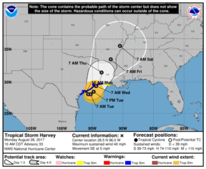
Map from National Weather Service. http://www.weather.gov/akq/Harvey

For the people of the Texas Gulf Coast, the rain and winds of Hurricane Harvey are just the beginning of a long journey. The storm will last a few days. The recovery will last years.
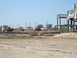
Destruction in the Bolivar Peninsula after Hurricane Ike in 2008

I am not there, so I can only surmise, based on the news coverage I have seen, the full extent of the damage and suffering that people are enduring in Corpus Christi, Houston, Galveston, and hundreds of other communities in a wide arc that has fallen under the impact of this storm. I do not even expect that people there will read this, certainly not right now. Nonetheless, it may be worthwhile to offer some insights to people elsewhere. I have never lived or worked in Texas, but I have been there numerous times and visited Louisiana more often than I can remember. I saw first-hand the devastation wrought in the Bolivar Peninsula and Galveston after Hurricane Ike. I have worked with people in Texas, including those at the Texas A&M Hazards Reduction and Recovery Center, over many years. They have educated me greatly on the vulnerabilities of their state.

With all due humility, therefore, but also with experience from other disasters over the past quarter-century, I offer some observations that may enhance what readers of this blog may learn from the news.
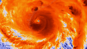
Photo from NOAA. The NOAA/NASA Suomi NPP satellite captured this infrared image of Hurricane Harvey just prior to making landfall along the Texas coast on August 25, 2017 at 18:55 UTC. NOAA’s National Hurricane Center has clocked Harvey’s maximum sustained winds at 110 miles per hour with higher gusts. Infrared images like this one can help meteorologists identify the areas of the greatest intensity within large storm systems, such as the areas with the most intense convection, known as overshooting cloud tops (dark orange), surrounding the eye and along the outer bands. https://www.nnvl.noaa.gov/MediaDetail2.php?MediaID=2086&MediaTypeID=1

First, this is apparently a somewhat unusual storm system. It approached the coast just northeast of Corpus Christi as a Category 4 hurricane, although it is now downgraded to a tropical storm. That does not make it less dangerous. The Saffir-Simpson scale that is used to rate hurricane strength deals only with wind speeds. Winds are certainly important, especially when they reach the 130 mile-per-hour range that was the peak for this event. Winds have, from all the visual evidence on the various news outlets I have watched, wreaked tremendous havoc along the coast, tearing apart buildings and overturning trailers and other vehicles. Moreover, hurricanes often spawn tornadoes, and some of the intermittent damage—that is, buildings ripped apart near others largely intact—suggests that this has occurred. In other words, if the more diffuse hurricane winds don’t get you, the tornado just might. It is no laughing matter. It is a wonder the death toll remains relatively low, although we almost surely don’t know the full tally just yet.

One specific impact that always accompanies coastal storms of this magnitude is storm surge, the waters pushed landward by the winds that in this case ranged from six  to twelve feet. These can do considerable damage in low-lying areas along the coast and may also exacerbate coastal erosion.

What makes the storm somewhat unusual also makes it dangerous even after being downgraded to a tropical storm. The storm system appears to have stalled a bit on Sunday and may even be backing out into the gulf for another landfall. At least two very serious consequences can flow from this. One is that the stagnant storm front will dump immense amounts of rain over consecutive days. The projected precipitation totals, even larger than what has fallen so far, mount up, so that projections for many communities range as high as 50 inches. Keep in mind that 30 inches is ample rainfall for an entire year in many parts of the country, and almost no city in the United States is prepared to absorb even half that amount in just a few days. The average yearly rainfall in Houston is just shy of 50 inches.

Moreover, as the storm moves back out over the Gulf of Mexico, it may regain strength that storms typically lose as they make landfall. Tropical storms draw their strength from the warmth of the water over which they pass until they make landfall, after which wind speeds begin to die down. The water of the Gulf right now is in the mid- to high 80s Fahrenheit, reportedly a full two to three degrees above average. That is the source of the strength of Harvey. Regaining any strength from the warm Gulf waters is not a good omen for the Texas coast, and as the storm moves slowly northeast, more of this will affect Houston than was originally the case. That is why we are seeing such intense scenes of flooding in Houston: The storm began with enormous amounts of moisture and has moved along the coast at a snail’s pace, at times just a mile an hour. As the week progresses, however, the storm is projected to move northeast over Louisiana and Arkansas, weakening along the way.

Of course, those warm waters raise questions about the influence of global warming, a topic that does not always receive a warm reception in Texas political circles. It is impossible to say that a specific storm like Harvey would not have happened but for climate change. It is also possible to say very credibly that warmer waters make stronger storms possible. Warmer waters can reflect seasonal and yearly variations, but over time they can also reflect climatic trends. For now, let’s leave it at that. People will have plenty of time later to debate this topic. In due course, as recovery proceeds, it should become a topic of reasonable, informed public discourse.

Other factors are at work as well. The sheer extent of flooding reflects the inexorable fact that the ground in any area has limited capacity to absorb rain. The hydrological cycle allows much rain under normal circumstances to drain into the ground, depending on the types of soil present in any given location. Sand absorbs very well but does not provide a very solid building foundation. Clay provides a better foundation but does not absorb water as quickly. Soil types matter, therefore, but in urban areas we have complicated matters greatly with large quantities of impervious surface that absorb little or no water by design. Impervious surface includes buildings (with the limited exception of green roofs), paved surfaces like roads, parking lots, and driveways, and other structural impediments to the movement and absorption of water. Houston is a very large metropolitan area with the fourth-largest population among major cities in the U.S. Although it is making strides, it is also far from the greenest city in America. Like most major cities, the percentage of impervious surface varies widely, depending on density levels in specific neighborhoods and corridors. Flooding is also influenced by the quality of the drainage systems; Houston is challenged in this respect by low-lying, flat terrain. It is criss-crossed with numerous bayous and canals that provide paths for the movement of water but also have serious limits to the water they can absorb before spilling over onto streets and highways. Those water-filled streets are the main obstacle to evacuation for those who stayed behind. There comes a point where people are better off remaining in place than trying to move, which is why Houston Mayor Sylvester Turner chose not to recommend evacuation.

Some dangers of mass evacuation for 6.5 million people are self-evident: clogged highways that are rapidly filling with water, producing death traps for people in stranded vehicles. Pedestrians cannot see steep drop-offs in elevation as they wade through high waters and can trip and drown. In Houston, the bayous may also contain alligators, water moccasins, and other wildlife hazards that are more easily avoided in dry weather. Moreover, the sheer volume of water can produce eddies and swirls that catch people off guard, and not everyone will be strong enough to regain their footing. Finally, flood water is always dirty water, sometimes just plain filthy, posing a potentially serious threat to public health.

All that said, many other major cities suffer from similar problems. I can think of no city that is prepared for the sheer volume of water currently falling along the Texas coast.

The Texas Gulf Coast communities, therefore, will emerge from this storm with a widespread pattern of both wind- and flood-related damage that will vary significantly from one area to the next, but collectively the costs will probably skyrocket into tens of billions of dollars. It is impossible to know the full costs just yet, but this will almost surely rank as one of the most expensive disasters in U.S. history. The recovery will take years of planning and implementation. If done well, it will involve a great deal of reassessment of patterns of development along the Gulf Coast and of the quality and importance of building codes. Social equity considerations will demand a new examination of the location and quality of low-income housing and the adequacy of affordable housing. Development regulations have seldom been politically popular in Texas, a state that still has never empowered counties to enact zoning codes. Some coastal communities may also wish to look more closely at the prospect of undergrounding utility lines to protect them from hurricane winds.

Events can push public attitudes in new directions. Part of that may depend on new lines of thought gaining traction in the discussion of rebuilding after the disaster. That may require some degree of courageous political leadership. Some very significant changes occurred in Louisiana after Hurricane Katrina, including consolidation of levee district management, adoption of a statewide building code, and a charter amendment in New Orleans that gave a new master plan more control over development regulations. We should not make perverse assumptions about outcomes, just as we also should not be naïve about the obstacles. But in my time at the helm of the Hazards Planning Center of the American Planning Association, we certainly worked hard to create a thorough blueprint for those willing to advocate better planning in response to major and catastrophic disasters, and I assume APA remains prepared to further that discussion and provide technical assistance where it can.

There will also be plenty of help available from the federal government, including the Federal Emergency Management Agency, the U.S. Department of Housing and Urban Development, and other agencies. We can only hope that Congress will sidestep much of its partisan bickering to ensure rapid allocation of the necessary resources. And we can hope that those resources and personnel are managed well to advance the recovery process, which is complicated and daunting.

One encouraging factor in the response has been the emergence of both willing volunteers and the effective use of social media to expedite search and rescue operations. The number of boats driven by volunteers rescuing people from rooftops and the interiors of flooded homes reminded me of the so-called Cajun Navy that operated throughout New Orleans in the desperate days that followed Hurricane Katrina. Disasters have a fortunate tendency in most cases to bring out the best in people, but we are also at a point in history where our new technologies facilitate the ability of willing heroes to find the people who most need help. Even the elderly and disabled are largely capable of dialing 911, or tweeting, or posting photos of their situation on Facebook, sharing their location, and pleading for help—and then finding their guardian angel at the front door with a motor boat. That is a huge advance from only a decade ago because it enables the willing volunteers to become effective heroes. If those civic and humanitarian instincts carry over into the slower grind of recovery, perhaps a stronger, more resilient Gulf Coast can yet rise from the mud, the grime, and the shattered buildings we see now.

Jim Schwab

New York City, Water, and Resilience

I was never a New York native, but I did not feel entirely alien, either, when I returned for the first of four visits to the area in January 2013, following Superstorm Sandy. My father lived in Queens most of his life and left only when my mother, who was from Cleveland, insisted on moving. New York City was not to her liking, and she wanted to go home. But my paternal grandparents remained on Long Island until they died in the 1960s, and we often visited. I was born in Bayshore Hospital, one of seven that were evacuated during the storm. My father had told me about living through the “Long Island Express,” the famous 1938 hurricane that also swamped much of New England. I was not a total stranger. I was certainly aware of many of the cultural traits that make New Yorkers famous (or infamous), though I think some consist more of popular stereotype than reality. But there is a certain toughness that comes from living in the Big Apple, even if it’s different from the toughness I have learned from my eventual attachment to Chicago, the alleged “City of Big Shoulders.”

Hence, despite all the vulnerabilities connected with a city of eight million people that is nearly surrounded by water, I instinctively understood the connection of the city with the concept of resilience. The city has withstood more than Sandy—this was the site of the worst 9/11 attacks, after all—and responds well to challenges. There are no feet of clay; the foundation of Manhattan is bedrock. But any map of the city makes clear that every borough but the Bronx is an island, and even that is a peninsula surrounded by water on three sides.

What brought me to New York after Sandy was a decision by the American Planning Association to assist our New York Metro and New Jersey chapters in preparing their members and communities for the arduous task of post-disaster recovery. To be honest, ours was a contribution more of solidarity and expertise than of resources, which had to come from the massive allocations of federal funds used or distributed by federal agencies, led mostly by the Federal Emergency Management Agency (FEMA) and the U.S. Department of Housing and Urban Development (HUD). What mattered to our members was our presence, our ideas, and the time we spent preparing and delivering a series of training workshops in April 2013 on planning for post-disaster recovery. It is fair to say that, as manager of APA’s Hazards Planning Center and the ringleader of that training effort, Sandy recovery dominated my life for the first half of 2013. And this is all context for my observations in reviewing a relatively new book from Island Press, Prospects for Resilience: Insights from New York City’s Jamaica Bay, edited by Eric W. Sanderson, William D. Solecki, John R. Waldman, and Adam S. Parris. Contributors include biologists, geographers, and engineers, among others with a wide range of expertise that contributes to the book’s comprehensive approach. its utility is clearly greater for professional practitioners in planning, civil engineering, public administration, and allied fields, as well as for academic researchers, than for purely casual readers.

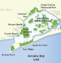
Map from Gateway National Park, National Park Service, website. https://www.nps.gov/gate/planyourvisit/map_jbu.htm

The book focuses specifically on Jamaica Bay, although New York City matters greatly as the municipal government making critical decisions that affect the bay’s resilience. Jamaica Bay, however, is an interesting case study of the intersection of geographic, ecological, industrial, and urban planning factors in both weakening and enhancing the overall resilience of a highly stressed water body and the urban neighborhoods that line its shores. The book’s most noteworthy feature is not any one approach to the subject of resilience for Jamaica Bay, but the way in which it seeks to cross disciplinary lines to undertake a thorough analysis of the prospects for building resilience in an area like Jamaica Bay. Researchers there may have much to share with those examining other ecologically challenged urban water bodies across the nation.

It is important to understand the geographic context of Jamaica Bay, an area familiar to most people (including many New Yorkers) primarily as the scenery below the airplane as it makes its descent into John F. Kennedy International Airport (JFK). The airport, in fact, has a significant impact on Jamaica Bay because it sits at the eastern end of the bay in Queens, the linchpin between the rest of Long Island and the Rockaways, a long, densely populated peninsula that stretches west from JFK and forms the southern boundary of the bay. That, in turn, means that the Rockaways, home to 180,000 people, is extremely vulnerable in a major storm like

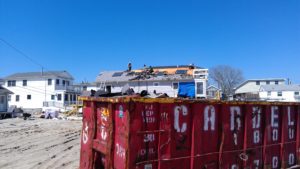
Fire devastated Breezy Point during Hurricane Sandy in 2012. Cleanup lasted for months. Photos courtesy of James Rausse.

Sandy. The Rockaways suffered some of the worst damages from the storm, including a fire that tore through Breezy Point, destroying 130 homes. Because of its isolation at the end of the peninsula, and the storm surge that inundated it, it was impossible for fire trucks to respond to the conflagration. For those curious about the origins of a fire in the midst of a flood or hurricane, it is worth remembering that a surge of salt water can easily corrode and short out electrical wires, triggering sparks. Much of New York’s subway system, well designed to pump out normal stormwater, was shut down during Sandy for the same reason.

What makes Jamaica Bay matter enough to devote nearly 300 pages to the subject? It is a great laboratory for resilience. The dense urban development that surrounds the bay stresses the natural ecosystems of the bay, whose biological composition has changed radically over time. The late 19th century witnessed the growth of a viable fishing industry, including oyster harvests, but pollution from sewage disposal and industry brought that to a sudden halt by the 1920s. The same factors reduced the bay’s recreational potential as well. Only in the last few years have there been efforts to restore the oyster beds, but like most such efforts, they will require ongoing research and attention to succeed.

Just as importantly, human communities need to become more resilient as part of a larger social-ecological system because the city is not about to disappear. There simply will be no return to pre-urban conditions. Urban stormwater drainage, sewage disposal, industrial activity, and transportation all have impacts that good urban planning must mitigate or prevent in trying to maintain a healthy urban relationship with the natural environment. Serious scientific inquiry may provide some answers. Greater levels of awareness and connectedness by area residents to the marine environment can also help, but that has often not been the case. An entire chapter explores neighborhood and community perspectives on resilience around Jamaica Bay. Few seasoned urban experts and planners will be surprised to learn that New York generally, and the Jamaica Bay watershed, feature remarkably diverse neighborhoods in terms of density, ethnicity and race, and income level, all of which influence those perspectives and influence community goals. New York is also a remarkably complex city in which residents of some areas in Queens can feel isolated from the center city in Manhattan, but may also feel more secure in their isolation. It is noteworthy that some areas at the western end of the peninsula were heavily populated by public safety personnel. All this influences people’s perspectives on proximity to, and connection with, the waterfront and public understanding of the relationship between human settlement and the ecological health of the bay, which is not always straightforward in any event. People can exert both positive and negative influences on that relationship. The good news is that the authors found that Sandy and the recovery process that followed had some useful impact on the perceptions that underlie those actions.

Given all that complexity, it will also be small surprise that the resilience of Jamaica Bay and its surrounding development is affected by a complex network of overlapping jurisdictional responsibilities that are sometimes in conflict. In addition to the city and its boroughs, a variety of federal and state agencies with varying agendas and authorities, including the New York-New Jersey Port Authority (responsible for airports including JFK), the National Park Service (Gateway National Park), and the National Oceanic and Atmospheric Administration (climate and coastal zones), overlay the influence of numerous private organizations and academic institutions. Add the flood mitigation and post-disaster recovery responsibilities of FEMA, and one is suddenly confronted with a multicolored collage that for some people can become bewildering.

The case of NOAA is interesting in that climate change is likely to affect the frequency of extreme weather events, which may further test the resilience of an already dynamic social-ecological system. As a scientific agency with significant meteorological and climatological expertise, NOAA has contributed to the array of modeling tools helping to analyze resilience in Jamaica Bay, although academic and other institutions have added to that toolbox. What is important ultimately is to bring together the various strands of research in cooperative efforts for integrative management. The good news, well described toward the end of this book, is that such cooperative efforts have produced the Science and Resilience Institute at Jamaica Bay for that purpose, with participation by decision makers from local, state, and federal agencies to help resolve those conflicting missions and adopt a comprehensive systems approach to the challenges facing the area. Let us hope that those decision makers, and the public officials controlling their resources, have the wisdom to maintain hard-won progress. As is true of many other areas in the U.S., those responsible for the health of Jamaica Bay have much work to do. The rest of us have much to learn from what they are doing and a stake in that progress.


Jim Schwab

Climate Resilience on the High Plains

For those who think only in terms of the politics of red and blue states, the conference I attended March 30-31 in Lincoln, Nebraska, may seem like a paradox, if not an oxymoron. It is neither. It is a matter of looking beyond labels to facts and common sense, and ultimately toward solutions to shared problems. The problem with climate change is that the subject has been politicized into federal policy paralysis. But the scope for local and even state action is wider than it seems.

The University of Nebraska-Lincoln (UNL) Public Policy Center with support from the High Plains Regional Climate Center (HPRCC) sponsored the conference on “Utilizing Climate Science to Inform Local Planning and Enhance Resilience.” I spoke first on the opening panel. The sponsors have been working with communities across Iowa, Missouri, Kansas, and Nebraska. Planners, floodplain managers, and civil engineers from eleven municipalities in those states participated, along with UNL staff, climatologists, the Nebraska emergency manager, and myself.

My job was to provide a national perspective on the subject from a national professional organization, representing the Hazards Planning Center at the American Planning Association. I talked about two projects we are conducting with funding from the National Oceanic and Atmospheric Administration: “Building Coastal Resilience through Capital Improvements Planning” and “Incorporating Local Climate Science to Help Communities Plan for Climate Extremes.” I made light of the fact that there was not a single coastal community among the four states of the region, but I added that the lessons from the first project are still relevant because every community plans for capital improvements, which generally constitute the biggest investments they make in their future. Capital improvements cover long-term expenditures for transportation and waste and wastewater infrastructure as well as other facilities potentially affected by climate change. In the Midwest and High Plains, instead of sea level rise, communities are watching a rise in the number and severity of extreme events on both ends of the precipitation curve—in other words, both prolonged drought and more intense rainfall. Drought taxes water supply while heavy rainstorms tax local capacity to manage stormwater. Both may require costly improvements to address vulnerabilities.

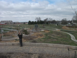
This park is part of the new urban amenity created for Lincoln residents.

I simply set the stage, however, for an increasingly deep dive over two days into the realities facing the communities represented at the workshop. Such input was an essential point of the conference. Different professionals speak differently about the problem; if planners or local elected officials are to interpret climate data in a way that makes sense politically and makes for better local policy, it is important for, say, climate scientists to understand how their data are being understood. There must also be effective information conduits to the general public, which is often confused by overly technical presentations. Moreover, what matters most is not the same for every group of listeners.

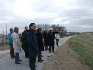
Glenn Johnson explains some of the planning of Antelope Valley.

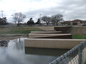
Some of the challenges, as well as the successes, were clear from presentations by two speakers who followed me to talk about the situation in Lincoln. Glenn Johnson is retired from the Lower South Platte Natural Resources District. Steve Owen is with the city’s Public Works and Utilities Department and spoke about the challenges related to water supply and quality, as well as flooding. At the end of the conference, we spent three hours touring Lincoln’s Antelope Valley project, an interesting combination of using a weir (small dam) and landscaping tools to create adequate water storage to reduce flooding in the downtown area. This had the interesting impact of removing some land from the floodplain and sparking redevelopment in what are now some of Lincoln’s most up-and-coming neighborhoods. At the same time, the project through creative urban

Now you know what a weir looks like (if you didn’t already). Photo courtesy of UNL.

design has allowed the city to create new urban park space and trails that enhance the urban experience for residents. Responding to climate and flooding challenges need not subtract from a city’s overall prospects; it can help enhance its attractiveness to both citizens and developers. The result is that good planning has helped make Lincoln a more interesting city than it might otherwise have been. That is a message worth considering amid all the political hubbub over climate change. We can create opportunity, but we must also embrace the reality. My guess is that this is why the other ten cities were present.

Jim Schwab

Step Forward on Water Hazards Resilience

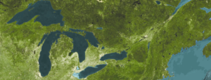
Satellite photo of Great Lakes and St. Lawrence Seaway. Image from NOAA Great Lakes Environmental Research Laboratory (CC BY-SA 2.0).

It is time to make America resilient. The trends have been moving us in the wrong direction for a long time, but we know how to reverse them.

Planners — and elected officials — have to embrace the science that will inform us best on how to achieve that goal, and we have to develop the political will to decide that public safety in the face of natural hazards is central both to fiscal prudence and the kind of nation we want to be. America will not become great by being short-sighted.

Damage from natural disasters is taking an increasing toll on our society and our economy. The National Oceanic and Atmospheric Administration (NOAA), currently the target for serious budget cuts by the Trump administration, operates the National Centers for Environmental Information (NCEI), a vital national resource center for data. It has long tracked the number and costs of the nation’s weather and climate-related disasters, and the conclusion is unavoidable: The number of billion-dollar disasters is growing and getting worse.

APA’s Hazards Planning Center has long studied and highlighted best planning practices for addressing the vulnerabilities that lead to such disaster losses. However, the uptake into community planning systems varies, and it is often a long process challenged by resource shortages.

In recognition of Water Week, I offer the following recommendations to Congress for ways in which federal partners and planners can work together to create stronger, more resilient communities:

Maintain funding levels

Maintaining the necessary funding support for agencies like NOAA is critical for providing us with the baseline information the nation needs to track data. It’s only through the ongoing coordination, maintence, and strengthening of national data resources that federal partners will truly be able to support local planning efforts. More data — not less — is the key to creating hazards policy that prepares communities for the future.

Translate science into good public policy

It is important to find new and better ways to translate science into good public policy. This is one of the objectives for NOAA’s Regional Coastal Resilience program — just one of the many important grants in danger of being defunded in FY 2018.

Support America’s coastal communities by ensuring that they benefit from projects directing the nation’s scientific and technical ingenuity to solve problems related to coastal hazards. The price tag is a tiny fraction of what the nation spent on recovery from Hurricane Sandy. The program is clearly a wise investment in our coastal future.

Reauthorize the National Flood Insurance Program

The National Flood Insurance Program expires this year. Reauthorization must include continued support for the flood mapping program so communities have essential baseline information on the parameters of their flooding challenges.

Municipalities and counties need accurate and current flood mapping and data in order to make more informed judgments on both how and where to build. Only then will the nation begin to dial back the volume of annual flood damages.

Pass the Digital Coast Act

Passing the Digital Coast Act means authorizing and enabling NOAA to provide the suite of tools, data, and resources under the Digital Coast program that have proved useful to local planners, coastal resource managers, public works departments, and water agencies in better managing coastal zones and the natural systems that keep them healthy.

Through the Digital Coast Partnership, APA has been a strong advocate for formalizing NOAA’s Digital Coast project through legislation and providing adequate federal appropriations for robust funding.

This legislation already has bipartisan support because the program shows government at its best in providing cost-effective support to scientifically informed public policy and decision making.

As APA Past President Carol Rhea, FAICP, has noted, “This legislation will directly improve local disaster response and hazard mitigation planning. This bill will help local communities minimize potential loss of life and damage to infrastructure, private property, and conservation areas. The Digital Coast Act is an important step for effective coastal management.”

Continue funding for the Great Lakes Restoration Initiative

The U.S. Environmental Protection Agency was created partly in response to the sorry condition of the Great Lakes and major tributaries like the Cuyahoga and Maumee Rivers. We have come a long way since then. The lakes and rivers are healthier, and the communities around them are, too. Yet the administration’s budget would zero out such programs despite their megaregional and even international impacts.

Recognize the progress we have made and renew America’s commitment to further improve these major bodies of water. Support coastal resilience along the Great Lakes.

These are not dramatic requests. Mostly, they recognize the slow but steady progress — and the persistent creativity — that has resulted from past commitments. They are, however, critical to successful water policy and to our national future as a resilient nation.

Jim Schwab

This post is reprinted from the APA Blog with permission from the American Planning Association, for which it was produced.

Make Community Planning Great Again

The American Planning Association (APA), the organization that employs me as the manager of its Hazards Planning Center, made me proud last week. It took a rare step: It announced its opposition to President Donald Trump’s 2018 budget proposal.

It is not that APA has never taken a position on a budgetary issue before, or never DSC00244spoken for or against new or existing programs or regulatory regimes. In representing nearly 37,000 members of the planning community in the United States, most of whom work as professional planners in local or regional government, APA has a responsibility to promote the best ways in which planning can help create healthy, prosperous, more resilient communities and has long done so. It’s just that seldom has a new administration in the White House produced a budget document that so obviously undercuts that mission. APA would be doing a serious disservice to its members by not speaking up on behalf of their core values, which aim at creating a high quality of life in communities of lasting value. That quest leads APA to embrace diversity, educational quality, environmental protection, and economic opportunity. Making all that happen, of course, is a very complex task and the reason that young planners are now largely emerging from graduate programs with complex skill sets that include the use of geographic information systems, demographic and statistical knowledge, public finance, and, increasingly, awareness of the environmental and hazard reduction needs of the communities they will serve. They understand what their communities need and what makes them prosper.

The Fiscal Year 2018 White House budget proposal, somewhat ironically titled America First: A Budget Blueprint to Make America Great Again, is in essential ways very short-sighted about just what will sustain America’s communities and make them great. Making America great seems in this document to center on a military buildup and resources to pursue illegal immigrants while eliminating resources for planning and community development. The proposal would eliminate funding for the U.S. Department of Housing and Urban Development’s Community Development Block Grant program, the HOME Investment Partnerships program, and the Choice Neighborhoods Initiative. It also eliminates the Low-Income Heating Energy Assistance Program, which was created under President Ronald Reagan, as well as the Department of Energy’s weatherization assistance program.

It also eliminates the Appalachian Regional Commission, which supports job training in the very areas where Trump irresponsibly promised to restore mining jobs. There is no doubt that hard-hit areas like West Virginia and eastern Kentucky are in serious need of economic development support. Trump’s promise, however, was hollow and reflected a lack of study of the real issues because environmental regulation, which the budget proposal also targets, is not the primary reason for the loss of mining jobs. The mines of a century ago were dangerous places supported by heavy manual labor, but automation reduced many of those jobs long before environmental protection became a factor. Competition from cheap natural gas, a byproduct of the hydraulic fracturing (or fracking) revolution in that industry, has further weakened the coal industry.

No rollback of clean air or climate programs will change all that. What is clearly needed is a shift in the focus of education and job training programs, and in the focus of economic development, to move the entire region in new directions. To come to terms with the complexity of the region’s socioeconomic challenges, I would suggest that the President read J.D. Vance’s Hillbilly Elegy, which deals compassionately but firmly with the deterioration of the social fabric in Appalachian communities. If anything, it will take a beefed up Appalachian Regional Commission and similar efforts to help turn things around for these folks who placed so much faith in Trump’s largely empty promises.

The March 9 issue of USA Today carried a poignant example of the realities that must be faced in producing economic opportunity in the region. The headline story, “West Virginia Won’t Forget,” highlights the problem of uncompleted highways in an area where a lack of modern transportation access impedes growth, focusing specifically on McDowell County, one of the nation’s most impoverished areas. It is hard for outsiders to grasp the realities. In the Midwest, if one route is closed, there are often parallel routes crossing largely flat or rolling land that maintain access between communities. In much of West Virginia, narrow mountain passes pose serious obstacles when roads no longer meet modern needs. It is the difference between the life and death of struggling communities, with those left behind often mired in desperate poverty. When I see a budget and programs from any White House that address these questions, I will know that someone wants to make Appalachia great again.

I say that in the context of a much larger question that also seems to drive much of the Trump budget. You must read the budget blueprint in its entirety, with an eye to questions of community and coastal resilience and climate change, to absorb fully the fact that the Trump administration is at war with any efforts to recognize the realities of climate change or facilitate climate change adaptation. The proposal zeroes out the National Oceanic and Atmospheric Administration’s coastal mapping and resilience grant programs. I will grant in full disclosure that APA, in partnership with the Association of State Floodplain Managers, is the recipient of a Regional Coastal Resilience Grant. For good reason: Our three-year project works with pilot communities in Georgia and Ohio to test and implement means of incorporating the best climate science into planning for local capital improvements. Communities invest billions of dollars yearly in transportation and environmental infrastructure and related improvements, and in coastal areas, ensuring that those investments account for resilience in the face of future climate conditions will save far more money for this nation than the $705,00 investment (plus a 50% match from ASFPM and APA) that NOAA is making in the project. The problem is that you have to respect the voluminous climatological science that has demonstrated that the climate is changing and that a serious long-term problem exists. And it is not just the focus of our singular project that matters. Today’s Chicago Tribune contains an Associated Press article about the race by scientists to halt the death of coral reefs due to ocean warming. The article notes that the world has lost half of its coral reefs in the last 30 years and that those reefs produce some of the oxygen we breathe.

The damage on climate change, however, does not stop with the NOAA budget. The Trump budget also zeroes out U.S. contributions to international programs to address climate change and undermines existing U.S. commitments to international climate agreements.

There is also a failure to take seriously the role of the U.S. Environmental Protection Agency, which would suffer a 31% budget reduction and the loss of 3,200 jobs. Among the programs to be axed is the Great Lakes Restoration Initiative, ostensibly on grounds that, like the Chesapeake Bay programs, it is a regional and not a national priority and therefore undeserving of federal support. That ignores the fact that four of the five lakes are international waters shared with Canada. It also ignores the history of the agency and its 1970 creation under President Richard Nixon, largely as a result of the serious water pollution problems experienced at the time.

IMG_0256Younger readers may not even be aware of some of this. But I grew up before the EPA existed; I was a college student environmental activist when this came about. When I was in junior high school several years earlier, our class took a field trip aboard the Good Time cruise, which escorted people down the Cuyahoga River to the shores of Lake Erie in Cleveland. The river was such an unspeakable industrial cesspool that one classmate asked the tour guide what would happen if someone fell overboard into the river. Matter-of-factly, the guide responded, “They would probably get pneumonia and die.” We have come a long way, and for those of us who understand what a difference the EPA has made, there is no turning back. I am sure that White House staffers would say that is not the point, but to me it is.

I am sure that, as with other agencies, one can find duplicative programs to eliminate, and ways to tweak the budget for greater efficiencies. That should be a goal of any administration. But in the broad sweep of the damage this budget proposes, I find it impossible to discern that motive in the butcher cuts the White House embraces. It is time to contact your Senators and U.S. Representatives. Ultimately, the budget is up to Congress, which must decide whether the new priorities make sense. My personal opinion is that they are short-sighted and ill-informed.


Jim Schwab

Think Globally, Adapt Locally

In times of political hostility to scientific truth, knowledgeable people sometimes wonder how we can progress without federal support for important initiatives such as adaptation to climate change. The answer, in a vibrant democracy, is that the truth often bubbles up from the bottom instead of being disseminated from the top. When the top is dysfunctional, as it currently seems to be, it is the creativity of local officials and their communities that often saves America from itself. For me, part of the joy of a career in urban planning has been watching and sometimes abetting the great local experiments that pave the way for an eventual federal and international response to pressing urban and environmental problems. The struggle to adapt successfully to climate change is one of those urgent problems. We may indeed confront a wave of scientific ignorance among some leaders in the Trump administration for a few years, but they should be aware that they cannot halt the wave of innovation as communities work to solve real problems.

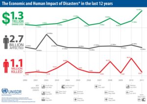
Denying that humans have contributed significantly to climate change through the Industrial Revolution and transportation driven by fossil fuel consumption will do nothing to stop sea level rise, nor will it prevent the bifurcation of extreme weather events that flattens the bell curve with fewer normal events and more high-precipitation storms and prolonged drought, which sometimes also feeds a longer and more intense wildfire season. Disasters happen, and the numbers don’t lie.

UNISDRAs a result, I was very happy a couple of years ago to be invited to join a Project Advisory Committee for the Kresge Foundation, which had hired Abt Associates to produce a report on climate adaptation at the community level. The foundation has supported a good deal of work related to community resilience and social equity in addition to making serious investments in the resuscitation of Detroit as a functioning urban community. Kresge wants to know what makes communities tick in responding to resilience challenges like climate change, and the study by Abt was intended to establish a sort of baseline for understanding the best practices in local planning related to climate adaptation.

I was thus involved in a series of all-day or multiday meetings of 16 project advisors from around the United States who reviewed and commented on the progress of the study for the consultants. Our meetings involved some serious debates about what constituted climate adaptation and resilience, and the degree to which communities needed to use such labels for what they were doing, or conversely, the degree to which we needed to recognize what they were doing as climate adaptation. Sometimes, we learned, adaptation may quack like a duck without being called a duck by local citizens and officials. What matters is what is accomplished.

Climate Adaptation: The State of Practice in U.S. Communities was officially released by Kresge Foundation in December; I will confess to being a little late in sharing the news, but at the time I was trying to recover from pneumonia. It took me a while longer to find time to read the report in its 260-page entirety, but I thought it important to do so to report intelligently on the final product. There is a difference between reviewing case studies in bits and pieces before committee meetings and seeing the full report between two covers.

I am happy to tell you that I think the nine authors who contributed to the report hit a home run. The bulk of its wisdom lies in 17 case studies spread across the nation, including some surprising places like Cleveland, Ohio, and the Southwestern Crown of Montana. I applaud Abt Associates for its work in even identifying many places that may not have been on the standard maps of leadership in climate resilience. Some of that can be attributed to maintaining an open mind about what they were looking for and what constituted innovation and success in adaptation. One thing that is utterly clear is that no two communities are the same, nor do they face the same problems. Ours is a very diverse country in spite of all that binds us together. Ours is also a nation of creative citizens who confront local problems based on local circumstances rather than “one size fits all” solutions. Perhaps that is why support from Washington does not always matter as much as we think, except in the international arena, where it is critical.

The example of Cleveland may be enlightening in this regard. While issues of social equity may not always seem like a logical starting point for engagement on climate adaptation, Cleveland is a city that was utterly battered by economic change from the 1970s into the early 21st century. The result is a community that is noticeably IMG_0256less prosperous than its surrounding metropolitan area, and has some of the lowest socioeconomic rankings among major cities nationwide. It is also a city that has lost more than half of its 1950s population, which peaked around 900,000. It is a city that may well say, in evaluating its place on the prosperity scale, “Thank God for Detroit.” That also means that no discussion of climate adaptation will move forward without a solid anchor in efforts to confront these inequities because it is hard to imagine how a community can become resilient in the face of climate challenges without also rebuilding economic opportunity for a badly battered working class. I know. I may have decamped for Iowa in 1979, but I grew up in the Cleveland area and worked my way through college in a chemical plant. Rebuilding prosperity in Cleveland has been tough sledding.

By the same token, climate change has had a direct impact on Montana, and the Southwestern Crown, a rural area of mountains and forests, has suffered the loss of timber industry jobs, which has in much of the Pacific Northwest resulted in some bitterness toward environmentalists. At the same time, nature takes a serious toll in increased wildfire damage, and at some point, if people of different perspectives can sit down for some serious discussions of reality, they can also imagine new futures for a region at risk. That has been the job of the Southwestern Crown Collaborative.

Pike Street MarketMentioning every case study here would not make sense. But it is worth noting that communities generally seen as not only prosperous but on the cutting edge of the new high-tech economy, such as Seattle, face other challenges that nonetheless tax local resources and resourcefulness. Seattle Public Utilities (SPU) became another Kresge case study, in large part, it seems, because its management needed to find ways to bring its staff and customers into the difficult realm of defining the threat and deciding how it could best be handled. SPU is responsible for managing Seattle’s water supply. When one confronts a future that portends potential water shortages as a result of decreased winter snow pack, leading to reduced snow melt that combined with drought can leave a huge metropolitan area high and dry, the need to recalibrate the system can be daunting. This case study is not important for providing precise answers to such questions, for there are none. Instead, it emphasizes the challenge of accustoming utility engineers and managers to an uncertain future, and helping them find comfort levels with uncertainty. What needs to change to make Seattle’s water supply resilient in the face of natural hazards? How does a city on Puget Sound cope with sea level rise? What plans will be adequate for protecting water supplies two or three decades into the future? In the end, the answers revolve around changing the culture of decision making within the organization as well as communicating those challenges clearly to the public. One product of SPU’s efforts, however, is a path forward for other communities facing similar long-term challenges.

Bottom line: This report is a great resource for those who want to descend from the heights of overarching theory on climate change to the realities of confronting the problem on the ground. Use this link, download it, and read it. Few resources in recent years have been so thorough in documenting the state of practice in climate adaptation at the local level. I am proud to have been involved even in an advisory capacity. I have learned a great deal from the process.

Jim Schwab


Making Natural Infrastructure Solutions Happen

From time to time, I contribute to the APA Blog, which consists of a variety of news and perspectives the American Planning Association provides to its members on its own website. Recently, I composed an article about an effort APA undertook in concert with several organizational partners to explore issues related to permitting of wetlands restoration projects and some of the obstacles such projects may face. For those interested, just follow the link: https://www.planning.org/blog/blogpost/9118459/.

Jim Schwab

Can You Sue the Government for Climate Change Impacts?

The American Planning Association has just posted today this article I wrote for its APA blog: https://www.planning.org/blog/blogpost/9111027/.

Jim Schwab

Hold That Soil, Please

Photo by Suzan Erem

Photo by Suzan Erem


Ours has often been a profligate society in using the vast natural resources with which it was originally endowed. We’ve improved our attitudes about conservation, but we have a long way to go. Among those resources we have been prone to waste in the interest of short-term gain has been the deep topsoil that made the Midwest superbly productive. Less than 200 years ago, according to Rick Cruse, an Iowa State University researcher, Iowa had an average of 14 inches of topsoil in which grew thousands of square miles of prairie. Now that soil is about six inches deep, less than half what we inherited—or more accurately, mostly took—from the Native Americans who first lived here.

Those estimates come from an August 12 article in the Chicago Tribune that I shall credit as the inspiration for my addressing this topic. However, those familiar with my first book, Raising Less Corn and More Hell, will be well aware that the topic is not new to me. In 1985, farmer Gary Lamb and I wrote an op-ed for the Des Moines Register decrying the lack of conservation and what it might do in the long term to the fabled productivity of Iowa farmland. In essence, we were saying, nothing lasts forever if we insist on killing the goose that lays the golden egg.

Farmers mostly tore up the prairie to plant the corn, soybeans, wheat, and other agricultural products that now grow on the vast majority of the land in states like Iowa, Illinois, Missouri, and Kansas. Prairie plants had deep roots that held topsoil in place and nurtured it. With prairie grasses removed, loose soil began to erode, clogging streams and rivers that feed the Mississippi River, which dumps its overload into the Gulf of Mexico, producing what has become known as a “dead zone.” This is an area suffering from hypoxia—a shortage of oxygen in the sea that chokes out life. This comes at the additional cost of stripping Midwestern farms of much of the topsoil with which they were originally blessed. We have unhinged that layer of topsoil by depriving it of the prairie root systems that once anchored it. In fact, we continue to do so.

But the problem is more serious and immediate than simply undermining the long-term productivity of the soil. Current practices also threaten the public health and welfare of people in states like Iowa. Not long ago, the Des Moines Water Works filed suit against three upstream counties for failing to control the nonpoint source runoff that is contaminating the capital city’s water supply. That suit is being met with a good deal of anger and skepticism, but it is symptomatic of a larger conflict. That conflict pits the priorities of agriculture versus public welfare, a dispute playing out in other forms in even larger venues like California. But there the issue often has more to do with drought and the protection of adequate water supplies than with polluted runoff. In Iowa, floods have been a more persistent danger in recent memory.

Lawsuits, however, are not the only rational response to such a major public policy problem. It is critical that public universities support research aimed at viable solutions, and at least some research at Iowa State University is pointing to an answer that should seem remarkably obvious: restore the prairie. The imperatives of modern food production may make it clear that we are not going to restore all the farmland in the Midwest to pre-modern conditions. But the prairie provides demonstrable ecological benefits that we can ignore only at the cost of prolonging current problems with flooding and water quality. In a sense, what we are learning about the value of restoring some prairie for the purpose of reducing runoff and improving downstream water quality is similar to what we are learning in more urban contexts about the value of green infrastructure—the urban forest, the green roofs, the living shorelines, and other nature-based features that enhance the environmental quality of our communities.

But green infrastructure is not a concept that need be limited to our urban areas. Nature provides vast ecological functions for human benefit in all sorts of settings if we are wise enough to investigate them and learn to use them.

In that sense, I think that Iowa State University is on to something. Researchers there have been demonstrating the value of prairie restoration with a project called Science-based Trials of Rowcrops Integrated with Prairie Strips (STRIPS). Test sites have shown not only that these prairie strips can capture much of the polluted runoff from farms and enrich the soil, but that they provide valuable habitat for birds and other wildlife, restoring some of the richness of the land in the process. For instance, one research project by Lisa Schulte and others showed that such treatments doubled or tripled the presence of bird species, both in overall abundance and variety. Other research has found that wider strips of prairie serve to trap greater levels of sediment that would otherwise clog streams and reduce water quality. It is as if, having been blind to the free benefits of natural systems for so long, we have at last begun to learn to sing nature’s tune anew.

But it will take time to change attitudes and perspectives in a farm sector that has often been rather conservative about adopting such techniques. There is still likely to be a lively debate between environmentalists and dominant sectors of the agricultural industry, with varying levels of resonance in different states, but results speak volumes and gradually help to change minds. There may be more lawsuits like the one that originated in Des Moines, and there may ultimately be some meaningful legislative debates about incentives and regulations. We can at least hope that the steady infusion of research-based information on the benefits of prairie restoration will make a difference soon enough to matter. There is certainly a great deal at stake.

Jim Schwab