Make Community Planning Great Again

The American Planning Association (APA), the organization that employs me as the manager of its Hazards Planning Center, made me proud last week. It took a rare step: It announced its opposition to President Donald Trump’s 2018 budget proposal.

It is not that APA has never taken a position on a budgetary issue before, or never DSC00244spoken for or against new or existing programs or regulatory regimes. In representing nearly 37,000 members of the planning community in the United States, most of whom work as professional planners in local or regional government, APA has a responsibility to promote the best ways in which planning can help create healthy, prosperous, more resilient communities and has long done so. It’s just that seldom has a new administration in the White House produced a budget document that so obviously undercuts that mission. APA would be doing a serious disservice to its members by not speaking up on behalf of their core values, which aim at creating a high quality of life in communities of lasting value. That quest leads APA to embrace diversity, educational quality, environmental protection, and economic opportunity. Making all that happen, of course, is a very complex task and the reason that young planners are now largely emerging from graduate programs with complex skill sets that include the use of geographic information systems, demographic and statistical knowledge, public finance, and, increasingly, awareness of the environmental and hazard reduction needs of the communities they will serve. They understand what their communities need and what makes them prosper.

The Fiscal Year 2018 White House budget proposal, somewhat ironically titled America First: A Budget Blueprint to Make America Great Again, is in essential ways very short-sighted about just what will sustain America’s communities and make them great. Making America great seems in this document to center on a military buildup and resources to pursue illegal immigrants while eliminating resources for planning and community development. The proposal would eliminate funding for the U.S. Department of Housing and Urban Development’s Community Development Block Grant program, the HOME Investment Partnerships program, and the Choice Neighborhoods Initiative. It also eliminates the Low-Income Heating Energy Assistance Program, which was created under President Ronald Reagan, as well as the Department of Energy’s weatherization assistance program.

It also eliminates the Appalachian Regional Commission, which supports job training in the very areas where Trump irresponsibly promised to restore mining jobs. There is no doubt that hard-hit areas like West Virginia and eastern Kentucky are in serious need of economic development support. Trump’s promise, however, was hollow and reflected a lack of study of the real issues because environmental regulation, which the budget proposal also targets, is not the primary reason for the loss of mining jobs. The mines of a century ago were dangerous places supported by heavy manual labor, but automation reduced many of those jobs long before environmental protection became a factor. Competition from cheap natural gas, a byproduct of the hydraulic fracturing (or fracking) revolution in that industry, has further weakened the coal industry.

No rollback of clean air or climate programs will change all that. What is clearly needed is a shift in the focus of education and job training programs, and in the focus of economic development, to move the entire region in new directions. To come to terms with the complexity of the region’s socioeconomic challenges, I would suggest that the President read J.D. Vance’s Hillbilly Elegy, which deals compassionately but firmly with the deterioration of the social fabric in Appalachian communities. If anything, it will take a beefed up Appalachian Regional Commission and similar efforts to help turn things around for these folks who placed so much faith in Trump’s largely empty promises.

The March 9 issue of USA Today carried a poignant example of the realities that must be faced in producing economic opportunity in the region. The headline story, “West Virginia Won’t Forget,” highlights the problem of uncompleted highways in an area where a lack of modern transportation access impedes growth, focusing specifically on McDowell County, one of the nation’s most impoverished areas. It is hard for outsiders to grasp the realities. In the Midwest, if one route is closed, there are often parallel routes crossing largely flat or rolling land that maintain access between communities. In much of West Virginia, narrow mountain passes pose serious obstacles when roads no longer meet modern needs. It is the difference between the life and death of struggling communities, with those left behind often mired in desperate poverty. When I see a budget and programs from any White House that address these questions, I will know that someone wants to make Appalachia great again.

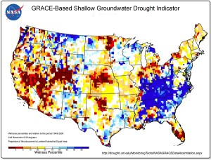
I say that in the context of a much larger question that also seems to drive much of the Trump budget. You must read the budget blueprint in its entirety, with an eye to questions of community and coastal resilience and climate change, to absorb fully the fact that the Trump administration is at war with any efforts to recognize the realities of climate change or facilitate climate change adaptation. The proposal zeroes out the National Oceanic and Atmospheric Administration’s coastal mapping and resilience grant programs. I will grant in full disclosure that APA, in partnership with the Association of State Floodplain Managers, is the recipient of a Regional Coastal Resilience Grant. For good reason: Our three-year project works with pilot communities in Georgia and Ohio to test and implement means of incorporating the best climate science into planning for local capital improvements. Communities invest billions of dollars yearly in transportation and environmental infrastructure and related improvements, and in coastal areas, ensuring that those investments account for resilience in the face of future climate conditions will save far more money for this nation than the $705,00 investment (plus a 50% match from ASFPM and APA) that NOAA is making in the project. The problem is that you have to respect the voluminous climatological science that has demonstrated that the climate is changing and that a serious long-term problem exists. And it is not just the focus of our singular project that matters. Today’s Chicago Tribune contains an Associated Press article about the race by scientists to halt the death of coral reefs due to ocean warming. The article notes that the world has lost half of its coral reefs in the last 30 years and that those reefs produce some of the oxygen we breathe.

The damage on climate change, however, does not stop with the NOAA budget. The Trump budget also zeroes out U.S. contributions to international programs to address climate change and undermines existing U.S. commitments to international climate agreements.

There is also a failure to take seriously the role of the U.S. Environmental Protection Agency, which would suffer a 31% budget reduction and the loss of 3,200 jobs. Among the programs to be axed is the Great Lakes Restoration Initiative, ostensibly on grounds that, like the Chesapeake Bay programs, it is a regional and not a national priority and therefore undeserving of federal support. That ignores the fact that four of the five lakes are international waters shared with Canada. It also ignores the history of the agency and its 1970 creation under President Richard Nixon, largely as a result of the serious water pollution problems experienced at the time.

IMG_0256Younger readers may not even be aware of some of this. But I grew up before the EPA existed; I was a college student environmental activist when this came about. When I was in junior high school several years earlier, our class took a field trip aboard the Good Time cruise, which escorted people down the Cuyahoga River to the shores of Lake Erie in Cleveland. The river was such an unspeakable industrial cesspool that one classmate asked the tour guide what would happen if someone fell overboard into the river. Matter-of-factly, the guide responded, “They would probably get pneumonia and die.” We have come a long way, and for those of us who understand what a difference the EPA has made, there is no turning back. I am sure that White House staffers would say that is not the point, but to me it is.

I am sure that, as with other agencies, one can find duplicative programs to eliminate, and ways to tweak the budget for greater efficiencies. That should be a goal of any administration. But in the broad sweep of the damage this budget proposes, I find it impossible to discern that motive in the butcher cuts the White House embraces. It is time to contact your Senators and U.S. Representatives. Ultimately, the budget is up to Congress, which must decide whether the new priorities make sense. My personal opinion is that they are short-sighted and ill-informed.


Jim Schwab

All’s Well at Burwell’s

Chad Berginnis shares a story during the roast. To his right is Nicole LeBouef, new Deputy Assistant Administrator for NOAA for the National Ocean Service. Photo by Susan Fox.

Chad Berginnis shares a story during the roast. To his right is Nicole LeBouef, new Deputy Assistant Administrator for NOAA for the National Ocean Service. Photo by Susan Fox.

Warmth is a concept with many dimensions. In the realm of physics, it is a relative measure of temperature. In reference to weather, perhaps the most common subject of human conversation, it is a measure of the kinetic energy of the atmosphere around us, which is constantly changing. Mark Twain has been erroneously quoted as saying, “Everybody talks about the weather, but nobody does anything about it.” His friend Charles Dudley Warner sort of said it, but no mind. On Tuesday, February 7, in Charleston, South Carolina, no one around me had any complaints. We were perfectly happy with the kinetic energy of the atmosphere of the day, which brought the city to a very comfortable 75° F. No rain, just a mild breeze. Let it be. (You can accurately take that quote from the Beatles.) Two days later, I would have to return to Chicago, where it was 18° F. when I stepped off the airplane.

Like many other English words, warmth takes on many metaphorical and emotional connotations derived from its physical qualities. “If you can’t stand the heat, get out of the kitchen,” President Harry Truman used to say, and he was not referring to room temperature in the White House. Conversely, there is the warmth of positive human relationships, just as there is a chill in the air when they are not going well.

That evening, at a downtown Charleston restaurant, Burwell’s, I experienced that warmth at a group dinner organized by some National Oceanic and Atmospheric Administration (NOAA) staff for those members of the NOAA Digital Coast Partnership who were attending the Coastal GeoTools Conference. The partnership consists of both NOAA, through its National Ocean Service, and eight national nonprofit organizations, including the American Planning Association, which I represented along with a colleague, Joseph DeAngelis, a research associate for the Hazards Planning Center. The conference was hosted for NOAA by the Association of State Floodplain Managers (ASFPM).

Susan Fox, NOAA point of contact for APA in the Digital Coast Partnership, presents a gift before the roast. Photo by Miki Schmidt.

Susan Fox, NOAA point of contact for APA in the Digital Coast Partnership, presents a gift before the roast. Photo by Miki Schmidt.

But enough of the organizational details. Shortly after all our carloads arrived at Burwell’s, and our party of 24 was led upstairs by the wait staff, it became apparent that something special was afoot. Miki Schmidt, Division Chief for Coastal Geospatial Services at NOAA, attempted to get people’s attention by clinking empty glasses. It wasn’t working, so I decided to use my booming voice to say, “Miki wants your attention.” That worked. Then he announced, to my surprise, that they wanted to honor my upcoming retirement with a few gifts, among which were a framed certificate of appreciation from the U.S. Department of Commerce for my service in supporting Digital Coast and a framed photograph of those who had attended the last full meeting of the partnership in Rhode Island in September 2016, signed by many of the attendees. The warmth of the professional and personal relationships built with colleagues since APA joined the partnership in 2010 became readily apparent to me in this unexpected moment.

Allison Hardin poses with the wolf; David Hart observes (September 2011). Photo by Melissa Ladd.

Allison Hardin poses with the wolf; David Hart observes (September 2011). Photo by Melissa Ladd.

Then we sat down, and the “roast” began. More than once, as Miki seemed ready to turn the floor over to me for the final word, someone new would pop up to offer stories both fun and serious. Yes, it was true that I had once, wearing a moveable wolf mask, climbed through the open window of a park shelter in Madison, Wisconsin, during an evening reception for a partnership meeting hosted by ASFPM, asking the whereabouts of “them three little pigs.” Undaunted by the momentary confusion my entrance engendered, Allison Hardin, a planner from Myrtle Beach, South Carolina, insisted on posing for a photograph with the wolf, who politely obliged. I was known (though not alone) in trying to provide such moments to enliven the more relaxing moments of partnership gatherings. When my “final word” finally came, I shared not only some enhancements of the recollected moments, but my own plans beyond APA, which I discussed in a recent blog post, “The Fine Art of Stepping Down.”

Still, the Digital Coast Partnership was also built through a great deal of hard work, which was also celebrated. The representatives of the groups involved worked hard over the past decade to build the partnership, which is now celebrating its tenth year. Meetings sometimes involved long discussions of how we could better collaborate, and we now often partner on important proposals and projects in which our complementary strengths facilitate important progress in achieving Digital Coast’s mission. NOAA established Digital Coast to advance the use of geospatial technology by coastal communities to improve and enhance coastal planning and resource management. Much of this consists of a substantial and growing of free, online tools and resources for mapping and visualization purposes. The partnership consists of the user communities that can help vet Digital Coast products and assist in their dissemination. But the operative Digital Coast slogan has been “More than just data.” It is the human dimension that matters, and the science and technology have been means to an end, which is enabling the achievement of noble coastal community goals such as environmental protection, hazard mitigation, economic sustainability, and climate resilience.

And so—I suppose it was appropriate that the organizers of the dinner chose to bring us to Burwell’s Stonefire Grill, which generates its own warmth through its comfort menu of steaks and seafood. Though it certainly can be pricey like any steakhouse (most steak entrees are between $30 and $40), the food is outstanding. Personally, I indulged in the lobster bisque for starters. It offered some of the deepest, most flavorful spoonfuls of joy of any bisque I have had in a long time. Alan, our waiter, was not lying at all when he told me it was great. On the subject of warmth, let me add that the wait staff of Alan, Mat, and Will were very patient and careful in tending to this large crowd, as was bartender Jo Jo Chandler. I did not meet the owner, John Thomas, but he is to be commended for both the staff and the cuisine. The Wagyu flat iron steak that I ordered was tender and delicious. I also indulged in a side order of Brussels sprouts, which I love but which require some attentive preparation to succeed. These were great in part because they were prepared in combination with caramelized onions. Others around me

Miki to the right of me in the upstairs dining room at Burwell's.

Miki to the right of me in the upstairs dining room at Burwell’s. Photo by Susan Fox.

enjoyed the seafood offerings, including oysters and scallops, and I heard no complaints and considerable praise. I can assure readers that, if you visit Charleston, Burwell’s is worth a visit for one of your evening outings. It also features a warm and casual atmosphere and a good downstairs bar, from which that amber beer in my hand originated, courtesy of Chad Berginnis, the executive director of ASFPM. I wasn’t sure, when we first arrived, why he offered to buy. Now I suspect he was in on the “roast” plan all along. Thanks, I say, to all of my friends at Digital Coast. My actual retirement from APA may have been almost four months away, but they knew this might be the last chance to do it before that day came. I hope they do the same for others when the time comes.

Jim Schwab


The Fine Art of Stepping Down

“The cemeteries are full of indispensable people,” or variations thereof, is a quotation that has been attributed to many, including the late French President Charles de Gaulle, but according to Quote Investigator, actually belongs to an American writer Elbert Hubbard in 1907, using the phrase, “people the world cannot do without” and the word “graveyards.” But QI notes numerous sources over the years, many of which may well have borrowed from or built upon the other. The point is clear: None of us lives forever, and the world finds a way to move on without us. We can make an impact, but so can others. And we can come to terms with those facts long before we arrive at the cemetery.

Although it was not made public until January 9, I decided a few months ago that it was time to leave my post at the American Planning Association as manager of the Hazards Planning Center. There are two other such centers at APA—Green Communities, and Planning and Community Health—each of which has had at least three different managers since the National Centers for Planning were established in 2008 as a means of making clear APA’s commitment to certain leading-edge topics in planning. I have so far been the only manager for Hazards.  More importantly, I built that center’s portfolio atop an existing legacy of work in the field of planning for hazards dating back to 1993, when I agreed to manage a project funded by the Federal Emergency Management Agency (FEMA) that led to publication of the landmark report, Planning for Post-Disaster Recovery and Reconstruction. I did not at first foresee the ways in which that effort would forever alter the arc of my career in urban planning. Looking back, there was nothing inevitable about it. While I was http://www.statenislandusa.com/heavily involved until then in environmental planning, almost none of it involved disasters. Once I sank my teeth deeply into the subject matter, however, there was no letting go. The Blues Brothers would have said that I was on a mission from God. Increasingly, I became aware of the high stakes for our society in properly planning our communities to cope with natural hazards.

One of the special pleasures of my position was the opportunity every summer to attend the Natural Hazards Conference in Colorado. Here, along with my wife, Jean, and daughter, Anna, in 2007, are some visitors from Taiwan whom I had met during a conference there the year before.

One of the special pleasures of my position was the opportunity every summer to attend the Natural Hazards Conference in Colorado. Here, along with my wife, Jean, and daughter, Anna, in 2007, are some visitors from Taiwan whom I had met during a conference there the year before.

That quarter-century tenure in the driver’s seat of APA’s initiatives regarding disaster policy and practice made me, in some people’s minds at least, almost inseparable from the position I now hold. Perhaps in part because I was comfortable in working with the news media, I became the public face of APA in the realm of hazards planning. That may have been amplified to some extent by the fact that, until last year, the only APA employees working directly under me on a regular basis were interns, most of whom were graduate planning students. It’s not that I was a one-man show. I enlisted staff within the research department for specific projects with assigned hours. Given the expertise needed in this area, and my own willingness to listen to and learn from the best, most experienced people available, it was generally productive to contract with those people on a consulting basis or through partnerships with other organizations. Because APA is a professional organization with a membership of almost 40,000, those resources were readily available. I could marshal expertise far greater than any we could have hired for most of those years. Last year, however, we came to terms with growth and added research associate Joseph DeAngelis, who joined us after leaving the New York City Planning Department, where he had worked on Hurricane Sandy recovery on Staten Island. He has become a great asset to the organization.

His ability to span the transition to a new manager was one of several preconditions I had in mind over the last two or three years in contemplating my retirement from APA. More important, but a factor in adding him to our staff, was that I wanted to leave my successor with a center that was in good shape. This meant having projects underway, and funded by agreements with sponsors beyond the immediate few months after my departure. By late last year, we had won project grants from FEMA and the National Oceanic and Atmospheric Administration (NOAA) that will all end between July and December in 2018. That gives my successor, whoever he or she may be, more than adequate opportunity to complete those ongoing projects, maintain APA’s credibility in the realm of hazards, and explore new options and opportunities that will sustain the legacy that is already in place. I understand that people like me sometimes move quickly to another organization, firm, or government agency because a huge opportunity opens on short notice. With retirement, however, there is no need for such haste. We can take time to plan well.

That leads to another precondition in which I can say that I am greatly aided by the management philosophy of APA’s current executive director, James Drinan. He believes that, when possible, we should seek a managerial replacement who can join APA in the last two or three weeks of the tenure of their predecessor. This allows the opportunity for the outgoing person to share how things are done or even answer questions about how they might be done better or differently. I recognize, for one thing, that my own package of skills is unique and unlikely to be replicated. That is fine because someone new may well be much stronger in some other areas than I ever was. And if so, I am happy for them. It is a fool’s errand to seek replacement by a clone. Ultimately, the hiring choice will belong to APA’s research director, David Rouse, but my input on what credentials and experience are most useful is likely to have an impact. We hope to see resumes from some high-quality candidates in coming weeks.

So what is next for me as of June 1? I look forward to an opportunity to explore some new options that simply have not been feasible until now. Elsewhere on this website, I describe my intended work on some future book projects, most immediately focusing on the 1993 and 2008 Midwest floods, but there are other ideas waiting in the wings. APA would like to use my consulting services as needed to aid the transition beyond my retirement, and I have agreed, but there are and may be some other offers. I will certainly continue teaching at the University of Iowa School of Urban and Regional Planning, at least as long as they wish to continue that relationship, which has been very fruitful. And it should surprise no one if people find me on the speaking circuit from time to time. In fact, I may be much freer to accept such invitations if I am not managing a research program for APA. Finally, I shall have considerably greater free time to devote to this blog. In less than four years, its following has grown from virtually nothing to more than 14,000 subscribers as of this week. It has been a great pleasure to share what I learn through that forum.

The opportunity to spend part of an afternoon just reading a book on a 606 Trail bench beckons.

The opportunity to spend part of an afternoon just reading a book on a 606 Trail bench beckons.

But those are all activities that somehow involve work. I may well involve myself in some volunteer activities with APA divisions and its Illinois chapter, the Society of Midland Authors, and other outlets that I may discover. That too sometimes sounds like work, so let me try harder. I have written about the wonderful 606 Trail near my home; I expect to walk and bicycle there and in nearby Humboldt Park. I may well take a great novel to one of the trail’s benches (or to my front patio) and read in the middle of the day. My wife and I may travel, both as we choose and as we are invited. Anyone reading this blog must already know that I love to get around. Despite all its flaws, the world remains a fascinating place, and I want to explore it while I can. I may never get a gig (or want one) like that of Anthony Bourdain, but I will see enough. And, yes, like him, I love to explore different cuisines—in part so that, as an amateur gourmet chef with new time on his hands, I can try them out for guests at home or elsewhere. Like I said, the world is a fascinating place. Explore it while you can.

Jim Schwab

Tools for Stronger Communities

dscf2307What makes a community stronger and more resilient in the face of severe weather threats and disasters? Clearly, preparation, awareness of existing and potential problems, and a willingness to confront harsh realities and solve problems are among the answers. Can we bottle any of that for those communities still trying to find the keys to resilience? Perhaps not, but we can share many of the success stories some communities have produced and hope that the knowledge is disseminated.

One agency with which I have worked at the federal level that seems to understand the value of partnerships with nongovernmental organizations, both business and nonprofit, in achieving this dissemination of critical knowledge is the National Oceanic and Atmospheric Administration (NOAA). At the American Planning Association (APA), we have worked with them through the Digital Coast Partnership, advancing the use of geospatial technology to improve coastal planning and coastal resource management, but also on water and climate issues. I personally participated on behalf of APA in a cooperative effort to assist NOAA in creating its Climate Resilience Toolkit, which aims to give communities and private sector stakeholders some of the tools and information they need to address issues of resilience in the face of climate change and extreme weather events.

More recently, I was very pleased to be part of an effort to add to the toolkit a Built Environment topic, or sub-toolkit. The Built Environment section aims to show that, “Cities and towns are vulnerable to sea level rise, heavy downpours, and extreme heat. Cooperative efforts of local government agencies and the private sector can promote adaptation by integrating physical resilience, social resilience, and nature-based solutions.”

A team of us, composed of people from federal agencies, academia, and national organizations, labored for months in contributing specific topics and material to the toolkit to ensure that it covered the most essential points and provided the most useful references to additional sources of information. I am especially happy to have recently completed the Planning and Land Use topic, after it survived the routine vetting by colleagues to ensure accuracy and effective message delivery. It was the last piece added, but I was very happy to put my own small stamp on the overall toolkit site.

The site is not intended to answer all questions; no site can. It is a window into the key issues, with additional resources, and a chance to reach those busy public officials and decision makers who do not have time to read entire tomes on issues like disaster recovery or transit resilience. It is more like a series of briefing papers for those looking for cogent ideas to address some of the most chronic, stress-inducing challenges community leaders face. The Built Environment is one of eleven major sections of the overall toolkit, each of which has a series of topics. For example, a section on Coasts includes several major topic areas such as sea level rise, coastal erosion, and tsunami, each with its own explanation and resources. It is an easily navigated one-stop source of information. The Climate Resilience Toolkit also includes case studies and an index of related tools.

Rummage around. You may find yourself still rummaging an hour later.

It is possible to wonder, and I am sure a few people are wondering, what the fate of such sites will be in a new administration that is highly skeptical of climate change. I don’t know the answer to that, but NOAA has been with us as a federal scientific agency for a long time, and I suspect it has a long future ahead of us. The agency includes the National Weather Service, National Marine Fisheries Service, and coastal management responsibilities. It is well-known as an employer of thousands of scientists, and its current administrator, Dr. Kathryn Sullivan, is both a geologist and former astronaut. She, however, will soon be gone, and it remains to be seen who will take her place.

NOAA, like the U.S. Geological Survey, is primarily a scientific agency. The fact that its mission includes a focus on climate science should not be a detriment. It should be a badge of honor, and any new administration would serve itself well by finding out what its experts have to say and why. The nation has seen some wonderful returns on its investments in fostering such expertise, and it would be foolhardy to curtail it now. The value of NOAA goes further, however, as Sullivan’s leadership in recent years has spurred the agency to seek to bridge the gap between scientific information and public policy decision making, a direction that has allowed Sullivan and many in NOAA to seek partnerships with information conduits like APA, which can effectively reach professional audiences who can multiply the dissemination capabilities of agencies like NOAA. All parties win.

It is critical not only to generate scientific knowledge but to share it with the public in plain English forums that deliver key points. That achievement is why I recommend checking out the Climate Resilience Toolkit. I’m proud to have been part of the effort.

Jim Schwab

Engaging Preparedness for Drought

NASA-generated groundwater drought map from the NIDIS website (https://www.drought.gov).

NASA-generated groundwater drought map from the NIDIS website (https://www.drought.gov).

Drought has historically been the disaster that fails to focus our attention on its consequences until it is too late to take effective action. While other disasters like earthquakes, hurricanes, tornadoes, and most floods have a quick onset that signals trouble, and a clear end point that signals that it is time to recover and rebuild, drought has been that slow-onset event that sneaks up on whole regions and grinds on for months and years, leaving people exhausted, frustrated, and feeling powerless. Our species and life itself depend on water for survival.

Over time, our nation has responded to most types of disasters both with an overall framework for response, centered on the Federal Emergency Management Agency, and with resources for specific types of disasters with operations like the National Hurricane Center. It took longer for drought to win the attention of Congress, but in 2006, Congress passed the National Integrated Drought Information System (NIDIS) Act, creating an interagency entity with that name, led by the National Oceanic and Atmospheric Administration. NIDIS was reauthorized in 2014. Its headquarters are in Boulder, Colorado.

For the last five years, I have been involved in various ways with NIDIS and the National Drought Mitigation Center (NDMC), an academic institute affiliated with the University of Nebraska in Lincoln. To date, the major byproduct of that collaboration has been the publication by the American Planning Association (APA) of a Planning Advisory Service (PAS) Report, Planning and Drought, released in early 2014. Both NIDIS and NDMC have helped make that report widely available among professionals and public officials engaged in preparing communities for drought. The need to engage community planners in this enterprise has been clear. Much of the Midwest was affected by drought in 2012, at the very time we were researching the report. Texas suffered from prolonged drought within the last few years, and California has yet to fully recover from a multi-year drought that drained many of its reservoirs. And while drought may seem less dangerous than violent weather or seismic disturbances, the fact is that, in the last five years alone, four drought episodes each exceeding $1 billion in damages have collectively caused nearly $50 billion in adverse economic consequences. The need to craft effective water conservation measures and to account adequately for water consumption needs in reviewing proposed development has become obvious. We need to create communities that are more resilient in the face of drought conditions.

A subgroup of the NIDIS EPC Working Group discusses ongoing and future efforts during the Lincoln meeting.

Part of the NIDIS EPC Working Group discusses ongoing and future efforts during the Lincoln meeting.

Over the past decade, NIDIS has elaborated its mission in a number of directions including this need to engage communities in preparing for drought. It was this mission that brought me to Lincoln at the end of April for the NIDIS Engaging Preparedness Communities (EPC) Working Group. This group works to bring together the advice and expertise of numerous organizations involved in drought, including not only APA, NOAA, and NDMC, but state agencies like the Colorado Water Conservation Board, tribal organizations such as the Indigenous Waters Network, and academic experts in fields like agriculture and climatology. Over ten years since the creation of NIDIS, this and other working groups have made considerable strides toward better understanding the impact of drought on communities and regions and increasing public access to information and predictions about drought in order to give them a better basis for decision making in confronting the problem. NIDIS has conducted a number of training webinars, established online portals for databases and case studies, and otherwise tried to demystify what causes drought and how states and communities can deal with it. Our job for two days in Lincoln was simply to push the ball farther uphill and to help coordinate outreach and resources, especially for communication, to make the whole program more effective over the next few years.

Much of that progress is captured in the NIDIS Progress Report, issued in January of this year. More importantly, this progress and the need to build further national capabilities to address drought resilience, captured the attention of the White House. On March 21, the White House issued a Presidential Memorandum signed by President Obama, which institutionalized the National Drought Resilience Partnership, which issued an accompanying Federal Action Plan for long-term drought resilience. This plan enhances the existing muscle of NIDIS by laying out a series of six national drought resilience goals: 1) data collection and integration; 2) communicating drought risk to critical infrastructure; 3) drought planning and capacity building; 4) coordination of federal drought activity; 5) market-based approaches for infrastructure and efficiency; and 6) innovative water use, efficiency, and technology.

Drought clearly is a complex topic in both scientific and community planning terms, one that requires the kind of coordination this plan describes in order to alleviate the economic burden on affected states and regions. With the growing impacts of climate change in coming decades, this issue can only become more challenging. We have a long way to go, and many small communities lack the analytical and technical capacities they will need. Federal and state disaster policy should be all about building capacity and channeling help where it is needed most. The institutional willingness of the federal government to at least acknowledge this need and organize to address it is certainly encouraging.


Jim Schwab


NOAA Provides Online Resources on Water

Watershed Assessment, Tracking and Environmental Results

Occasionally, I have used this blog to link to American Planning Association blog posts that I think some readers may find important. That is the case here: At the APA blog, I provide a brief introduction to a wonderful new resource for communities on a variety of water-related issues, ranging from not enough (drought), to too much (flooding), to not good enough (water quality), and other aspects and manifestations of the numerous ways in which water influences our lives and the way we build and move around. I am pleased to have played a role on behalf of APA in helping vet and shape this new resource.

What is it? The National Oceanic and Atmospheric Administration has created a Water Resources Dashboard for those needing timely information on water from a number of perspectives. Check it out. It is a great example of how a user-friendly federal agency can provide a great service to citizens and communities and raise the level of scientific awareness generally.

Photo from NOAA Water Resources Dashboard site

Jim Schwab

Water: Our Public Policy Challenge

R1-08402-021AI grew up in suburban Cleveland. After a seven-year hiatus in Iowa and briefly in Nebraska, my wife’s home state, we ended up in Chicago. I am unquestionably a Midwesterner with most of my life lived near the Great Lakes. It will therefore not be surprising that for most of my adult life, I have heard people speculate about moving some of our abundant water to places that have less, mostly in the West. For just about as long, I have been very aware that their speculations were merely pipedreams (pun very much intended).

Because most people have at most only a cursory understanding of our nation’s intricate water laws and treaties (in the case of the Great Lakes), to say nothing of the costs and challenges of water infrastructure development, I suppose they can be forgiven for their naivete in even entertaining such notions as piping water from Lake Michigan to California. For both legal and practical reasons, the water is not likely any time soon to leave the Great Lakes Basin, let alone find its way to the West Coast. Enough said.

That is all backdrop to noting that, at the moment, Lakes Michigan and Huron, which essentially share identical water levels because they are joined by a strait, are experiencing rising water levels after declining to levels well below average in 2012, in the midst of a drought and high temperatures. The lack of precipitation and high evaporation levels reduced the two lakes to 576 feet above sea level, about 2.8 feet below the average since 1918, when the Army Corps of Engineers began keeping records. All the Great Lakes tend to rise and fall over time, and somewhat in tandem because they are part of a continuous system that flows into the St. Lawrence River and out into the Atlantic Ocean. But Lake Superior is higher before it dumps into Michigan and Huron, which are higher than Lake Erie, and certainly Lake Ontario, which is on the receiving end of Niagara Falls. Gravity is obviously how all this water finds its way to the sea.

High recent rainfall—in June we had seven inches in Chicago with lower temperatures than normal—has kept the lake levels rising. Colder winters because of the polar vortexes have maintained ice cover, reducing evaporation. As a result, the lakes are now three feet higher than they were in 2012. Amid all this rise and fall, some facts should be noted: These lakes are thousands of years old. They are the result of glacial melt as the Ice Age receded, so most of the water is the result not of precipitation but of ancient glacial retreat. And our record keeping is less than a century old, so what we think we know about the long-term fluctuation in water levels, let alone what we can accurately predict about long-term impacts of climate change in the Midwest, remains far less than what we might ideally like to know. There are big gaps in our knowledge that can only partially be filled with other types of scientific analysis.

Nonetheless, based on such limited knowledge, the urge to build on shoreland materializing from nothing more than historical fluctuations sometimes motivates unwise development. Communities along the Great Lakes need to invest in wise lakefront planning that takes those fluctuations into account and does not create new hazards that are sure to arise in the face of lake levels that often rise again faster than we anticipated. Adequate buffers based on such fluctuations must be a part of the zoning and development regulations throughout such areas. It is best we approach what we know about Great Lakes water level fluctuations with a dose of humility and caution, lest nature make a fool of our aspirations.

There are resources for that purpose. Many of the state Sea Grant programs, based at state universities, can offer technical assistance. The National Oceanic and Atmospheric Administration, whose Coastal Zone Management Act responsibilities include the Great Lakes, has been developing resources for Great Lakes states. Using NOAA funding, the Association of State Floodplain Managers, with partners like the American Planning Association (APA), has developed, and is still expanding, a website containing its Great Lakes Coastal Resilience Planning Guide. It consists of case studies, a Great Lakes dashboard, and other tools. NOAA’s Digital Coast Partnership has been working with cities like Toledo, Ohio; Duluth, Minnesota; Green Bay, Wisconsin; and Milwaukee to address flooding and development problems along the Great Lakes in varying contexts.

I mention all this because, even amid this temporary abundance of water on the Great Lakes amid a withering drought on the West Coast, water, as always, remains a preoccupying public policy challenge everywhere around the world and across the United States. It is not nearly enough of a focus of public debate, however, and the complexities of the issue seem to evade most people’s attention, including those who ought to be thinking harder about it. Even those who do focus on the question are often siloed into narrow segments of water policy—wastewater, drinking water, flood protection and mitigation, drought planning, coastal zone management, and so forth. We need to approach water challenges more holistically.

APA’s board of directors approached the subject with that larger picture in mind in empowering a special task force to examine the issue. About two months ago, the task force released its report, which began by emphasizing that “water is a central and essential organizing element in a healthy urban environment.” It went on to call for viewing water resource management as “interdisciplinary, not multidisciplinary,” in other words, calling for collaboration among the professions involved. But it also called on the planning profession and university planning schools to provide more training, more education, and more resources centered around the subject of water and its importance to our society. And it calls for APA to “partner with national water service membership agencies” to “foster cross-industry participation and learning opportunities.” It is a far-reaching document that planning leadership in the U.S. is still absorbing, including me. But I commend it as an overdue conversation so that our future conversations about who uses water how, and for what purpose, can be considerably more sophisticated, as they clearly need to be.

We need to move away from pipedreams to serious conversations. Whether in California, where there is too little, or the Great Lakes, where there is currently plenty, we need to get it right because the stakes are high. Very high.


Jim Schwab

Charleston Charm

DSCF2878There is something mildly disconcerting about visiting an intriguing city several times without having the spare time to go tourist. I first visited Charleston, South Carolina, in 2003, for a business meeting with the National Fire Protection Association, for which I led an American Planning Association consulting project evaluating the impact of NFPA’s Firewise training program. I wandered a few blocks from the hotel but got only a cursory impression of what the city had to offer. In more recent years, I have been there repeatedly for various meetings and conferences connected to the National Oceanic and Atmospheric  Administration’s Coastal Services Center. This led to considerable familiarity with some of the local hotels and restaurants but still did not afford many opportunities to simply wander.

This year, I decided to fix that problem. My wife, Jean, had never been there. We chose our 30th anniversary (June 8) as an excuse for a four-day visit. Besides, it was time for a vacation. Proposals, projects, meetings, and budgets could all wait.

Even as a vacation, it was a view of Charleston through the eyes of an urban planner. None of us leave our experience, knowledge, or even our biases behind. Mine lean toward intellectual inquiry and a fascination with history. Charleston is chock full of history and geographic challenges, which make for interesting environmental history. The old city sits on a once marshy peninsula facing the Atlantic Ocean with the Cooper River to one side, and the Ashley River to the other. Plantations and a thriving rice culture were once built on those foundations. The rice culture, however lucrative it may have been, was built on one other foundation that vanished after the Civil War: slavery. With its demise, and the rise by the late 19th Century of agricultural machinery for rice growing in Texas and Arkansas, rice died as a central feature of the South Carolina economy.

DSCF2872The story is told vividly in the South Carolina Lowlands exhibit in the Charleston Museum, a two-story building on Meeting Street along what is known as the Museum Mile. As that sobriquet suggests, the city has a great deal to offer in this respect, most of which we did not have the time to visit. The offerings include a Children’s Museum of the Lowcountry, the Confederate Museum, and the Gibbes Museum of Art, currently being renovated, among several others. The Charleston Area Regional Transit Authority makes these attractions readily accessible to visitors with three free trolley lines that come together on John St. in front of the Visitor Center, which sits between King St., largely a commercial corridor, and Meeting St. Of the three, the Green Line (#211) runs the length of the Museum Mile.

From our perspective, the history of the South Carolina Lowcountry makes up the best piece of the exhibits the Charleston Museum offers, and clearly the most extensive, using a combination of glassed display cases and short videos to tell the story from prehistoric Indian tribes to European settlement and Indian displacement, to colonization, the American Revolution and Civil War, to modern Charleston. Another exhibit, for those more biologically inclined, details the flora and fauna of the region, and two other, smaller exhibits display both the clothing of the area over time, and the furnishings and metalware of the early American presence. It is enough, if one is diligent about it, to occupy the better part of a day. The museum also contains an auditorium for special events.

The Joseph Manigault House, viewed from the Temple Gate.

The Joseph Manigault House, viewed from the Temple Gate.

The museum also owns two old houses that have been preserved and are open to the public. The Joseph Manigault House, named after a French Huguenot descended from religious fugitives to America in the 1600s who became wealthy planters by the early 1800s, was designed by the owner’s brother and completed in 1803 using Adam-style architecture. Among its features is a Gate Temple that was left intact in the mid-20th Century even as an Esso gasoline station operated on the property before the museum finally acquired it well after World War II. During the war, it was used by the USO to entertain service men stationed in Charleston. It is on Meeting St. across a short side street from the Charleston Museum.

The Heyward-Washington House, on the other hand, requires either a long walk down Meeting St. or a ride on the Green Line to the corner of Broad and Church St., at which

Backyard gardens of the Heyward-Washington House.

Backyard gardens of the Heyward-Washington House.

point one hikes a block south to a home modestly tucked between other buildings in an area that was urban even when the house was built, just before the American Revolution in 1772. It belonged initially to Thomas Heyward Jr., among other things a signer of the Declaration of Independence, but it never belonged to a Washington. President Washington, during a tour of the southern states in 1791, simply stayed there for one week in June as a guest of the Heywards. More interestingly, the home later became the property of John F. Grimke, who with his wife produced two daughters, Sarah and Angelina, who developed profound differences with their rich, slave-owning, planter parents. The daughters became radical abolitionists. Needless to say, they became less than welcome in South Carolina, which posted a warrant for their arrest. That never happened because they resettled in Philadelphia, where they became Quakers, allied themselves with other abolitionists, and continued their activities, speaking and writing widely for their cause. There is no doubt they remained a thorn in the side of their southern kin until the day they died.

DSCF2828But by now I am well ahead of, well, our trip. Neither the Charleston Museum nor the two historic homes were among the first things we saw. In fact, we arrived on Sunday, relaxed over brunch at the eminently affordable yet well-managed Town & Country Inn & Suites in West Ashley, a quieter part of the city west of downtown across the Ashley River, and finally made our way across not only the Ashley but the Cooper River, traversing the magnificently attractive Arthur Ravenel Bridge to Patriots Point in Mount Pleasant. The dock is home to the U.S.S. Yorktown, a World War II aircraft carrier now preserved as a museum for visitors. We did not happen to buy tickets for that while we were there, but it does look impressive from dockside.

DSCF2836We did have tickets for a dinner cruise that evening aboard the Spirit of Carolina, a much smaller vessel designed to provide a pleasant experience for those who like to eat a fine dinner while watching the waves and the birds and the pleasure boats in Charleston Harbor. Both of us enjoyed a well-prepared meal of rib-eye steak, foreshadowed by she-crab soup and a house salad, accompanied by a bottle of champagne provided for our anniversary, and topped off by key lime pie for dessert. To DSCF2831be honest, I do not expect the absolute best of cuisine on dinner cruises; there are some natural limitations built into the format. The cruise is the point of it all. But this was excellent nonetheless. We both came away satisfied. With the help of some gentle guitar music and the breezes that greeted us during our short visit to the upper deck, it was an enjoyable way to celebrate an anniversary. By 9:15 p.m., as our boat pulled ashore to let everyone out, we felt our hosts had treated us to a very pleasant evening.

The next day our target was the South Carolina Aquarium. Given the geography, and aquatic and maritime history, of Charleston, this aquarium is a natural feature of the city. It is situated on the eastern waterfront of Charleston, a few blocks east of Meeting St., but also accessible by trolley. (It also hosts a parking garage.) One can easily DSCF2841spend a day there, and we spent most of a day there, absorbing the living exhibits of sea life that give patrons insights into aquatic life of all sizes and the ecological challenges facing much of it today. With such scientific powerhouses as NOAA nearby, one has high expectations of the aquarium for its scientific content, and by and large it delivers. One unusual feature, somewhat removed from its context, is the Madagascar exhibit, including some lemurs in a tree. I do not profess to know how that fits with the rest of the material, but it is edifying nonetheless. One learns of the utterly tiny amount of paved roads on an island nearly the size of Texas with nearly as many people but a declining rainforest. More related to the region, we discovered to our surprise an entire section devoted to piedmont ecology, examining the river life and aquatic ecology of the foothills of the Appalachians. If you can afford the time, the aquarium is well-endowed with such pleasant surprises. We arrived late in the morning but did not leave until about 4 p.m.

DSCF2834Although we did not find time to undertake the tour to Fort Sumter, we did visit the Fort Sumter National Monument, a modest building next to the aquarium that houses some displays pertinent to the battle that launched the Civil War when Confederate forces shelled the Union fortress on a small island in Charleston Harbor. Tour boats depart from the piers behind the building, and it is probably worth a visit. I hope to accomplish that on a future trip. The Fort Sumter National Monument, unlike the tour, is free and open to the public, and managed by the National Park Service.

DSCF2860That evening, we cheated, but who cares? We engaged a second establishment, Stars, in helping us celebrate our anniversary, this time on the actual date. I have previously reviewed Stars on this blog. So why not try something new instead? For starters, Jean had never been there; I had been there with colleagues during business trips. After reading my most recent review, Jean insisted she wanted to try the place herself, so I made a reservation. Upon arrival, after checking in with the maître d’, I took her upstairs to see the rooftop bar, where we were promptly served Bellinis, after a short explanation of a drink new to both of us. We loved it. Back downstairs, we got the royal treatment from a waiter who one of the owners subsequently informed us was “Big John,” as opposed to “Little John,” also working there, who was at that moment at the front of the restaurant. Big John had migrated from up north but, for the moment at least, found Charleston to his liking.

This time, we diverged in our orders, Jean getting steak (with black truffle grits and bacon braised mushrooms) while I ordered sea scallops. But neither entrée, while excellent, stole the show, at least in our estimate. That honor was reserved for a special share plate that featured cauliflower and broccolini roasted in a cheddar cheese sauce that was as good and succulent as any appetizer I can remember in a long time.

DSCF2868On Tuesday, our afternoon visit to the Charleston Museum followed a morning visit to the Waterfront Park, much closer to the Battery at the end of the peninsula than to the aquarium and most of Museum Mile, but still accessible by trolley. The park is simply a wonderful outdoor setting in which to view the ocean, complete with fountains, palm trees, and walkways along the water’s edge. It is a very pleasant place to pass some time, especially on a warm summer day. It looks like a wonderful venue for an outdoor wedding and has been used that way. For those who simply want to use their laptop or mobile device while occupying one of many park benches, it is also fully equipped with wifi, courtesy of Google and the Charleston Digital Corridor.

Hiking up the street past the old Custom House and turning left at Market St., we reached the popular City Market, a stretch of airy long buildings containing booths featuring numerous local artists and jewelry makers, among others. From one of them I eventually bought a small matte painting of a tropical seashore for my office. It will serve me well on cold Chicago winter days. We also ate lunch at an open air restaurant nearby, the Noisy Oyster, which offered commendable seafood at very reasonable prices. (By this time we were looking to limit both our food expenditures and our caloric intake.) From City Market we took the trolley back to the Visitors Center, where we had parked in the garage for the day, but first took our detour into the Charleston Museum, across the street.

After leaving the museum to get our car, however, we noticed the ominous, heavy gray clouds gathering overhead. Something told us the better part of wisdom lay in returning to our hotel, where we could read our books. (I was working on the H.W. Brands biography of Ben Franklin, The First American. I like to tackle the 700-page heavyweights during vacations.) By the time we arrived at the hotel, the rain was beginning to drip but not coming down very fast. Soon enough, however, the lightning and thunder mounted, and the rain pounded. On the television, we saw news reports from King St. showing cars struggling through several inches of water. I soon learned that much of downtown is either below sea level or at very low elevations with poor drainage, making for a chronic problem of urban flooding. Charleston, also subject to tropical storms such as Hurricane Hugo, which devastated the area in 1989, was not quite the seaside paradise we had enjoyed until then. It is, in fact, one very vulnerable coastal city that also experiences occasional tremors from a fault that triggered a major earthquake in 1886. Charleston needs good disaster plans.

Charleston needs a few other things as well. On our final day, after visiting the Heyward house, we took a long stroll up King St. back in the direction of Stars and the Visitors Center. On a hot day, that can be challenging, so we tried our best to hew to the shady side of the street, though at noon in June, there is a period when no such thing exists. What does exist is a wide variety of old and new storefronts, and we ended up buying some flip-flops and shoes in an H&M store, lunch at the 208 Kitchen, a pleasant little lunch establishment with good sandwiches at single-digit prices, and delicious Belgian gelato at a small store called, well, Belgian Gelato. Eventually, Jean, having finished off her murder mystery, wanted something new to read and found out there was a Barnes & Noble bookstore around the corner from the Francis Marion Hotel, a charming historic place where I have stayed on several previous trips to Charleston. She decided to try Identical by Scott Turow, a Chicago-area writer and fellow member with me of the Society of Midland Authors.

So what does Charleston need? As helpful as the trolley is, and although there is bus service provided by CARTA, it is clear that the creaking, older part of the city is ultimately facing a challenge of mobility as a result of too much dependence on the automobile. Light rail would help, and some people told me it had been discussed, but the big question is how to retrofit it into the existing fabric of this historic core of the city.

DSCF2880With all the tourism the city is now attracting, it is also facing the classic challenge of most such aging urban magnets of maintaining affordable housing for the workforce it needs to support such attractions within a reasonable distance of their employment. Already there is an obvious outmigration of the working poor to areas like North Charleston, a suburb that has very recently experienced toxic racial tensions between citizens and police, particularly after the shooting of Walter Scott this spring. When we researched hotel prices in preparation for our trip, it became obvious that the downtown area is experiencing significant price escalations. Charleston can easily allow the old city core to become a playground for the affluent, a tax generator as such, but it cannot afford to lose its character in the process. Charleston has come a long way since the lunch counter sit-ins of 1960 and the segregationist politics of Strom Thurmond. The challenge now is to preserve its well-earned reputation by honoring that progress in a progressive fashion. A cursory reading over breakfast of local newspapers told me that issue is far from settled in the development debates that are currently underway.

Jim Schwab

Can Data Be Resilient?

photoBefore attending the NOAA Coastal GeoTools Conference in North Charleston, South Carolina (March 30-April 2), I had not spent much time thinking about data resilience. A brilliant scientist now working for ESRI, the leading company in geographic information services, drew my attention to this important question. But first, a note about the delay:

Almost a month ago, I passed along a link to an article in the Post &Courier of Charleston, South Carolina, that reported on two presentations at the conference, one of them mine. I promised more material from that conference, but the following week, illness took hold of me for a day or two, and soon after, I was consumed with preparations for a trip to the American Planning Association’s National Planning Conference in Seattle, April 18-21. The next day, I flew on to Denver and attended a two-day Project Advisory Committee meeting for the Kresge Foundation, which is pursuing its own program concerning community resilience. Now that all that is over, and I have a modicum of free time, I want to circle back to report on both conferences.

Let me start with a fascinating presentation by Dawn Wright, for 17 years a professor of geography and oceanography at Oregon State University before becoming chief scientist for ESRI in 2011. Wright was the main plenary speaker at the conference on its opening day, March 31. (March 30 was devoted to a series of special interest meetings.) Wright launched into her speech by referring to information as the “fourth branch of government” as a means of underscoring its growing importance in the digital era. Like many good speakers these days, Wright was also a fountain of recommendations about great new books, including The Fourth Paradigm, available for free download from Microsoft Research. Wright noted that we are now afloat in data, to the point where she introduced the term zetabytes, which equal one billion terabytes, which not so long ago seemed like massive units of data, but Wright says we are approaching 40 zetabytes in the current digital universe. But what does this mountain of data really mean for users? How useful is it?

Wright said this emphasizes the importance of metadata, that is, data about the data, and that we are facing a huge problem in “dark data,” data that is not tagged or properly analyzed, making its utility more problematic. “Just making data and code available is not good enough,” she stressed. “We need to be more open and transparent about what we do with them. There is a need for interoperability and cross-walking.” She then said that ESRI would practice what it preached, citing its sharing of work flows and use cases at www.esriurl.com/workflows. She also noted that ESRI has joined forces with the U.S. Geological Survey in creating the global ecological land units map.

She then stressed the importance of digital resilience, noting that “human communication skills are still paramount.” She cited a recent Washington Post op-ed article by Fareed Zakaria, “Why America’s Obsession with STEM Education is Dangerous.” The acronym refers to science, technology, engineering, and mathematics, the collective focus of some recent education policies; Zakaria’s point was not that STEM education itself is wrong, but that a parallel focus on the liberal arts helps create students, and eventually adults, who not only have technical or scientific skills but the ability to ask and articulate fundamental questions. This led Wright to state that we need to learn how to “read deeply” in order to ask ourselves the tough questions.

The days when scientists can isolate themselves in ivory towers are over, Wright seemed to be saying, as she stressed the need to “write compellingly” and “think critically to analyze ideas.” For programmers, she stated that, “If you can organize your thoughts, you can organize your code.”

But there was a still larger theme in a world where the job environment is constantly shifting and evolving. Training, she said, “is not just for your first job, but for your sixth job.” Critical thinking is critical for navigating these transitions in life when some job skills are obsolete within a decade. She added that there are still not enough people “squarely in the community” of the emerging field of data science. She questioned why there was still no formal accredited academic degree in coastal or ocean data management, for example, and her own book on the subject, Ocean Solutions, Earth Solutions.

She also underlined the importance of knowing the “design story behind a product,” a subject she took up the next day in a session on “story maps,” a translational tool for users that allows science students to tell their story. In that session, she noted positive change in that “students now want to escape the ivory tower.” She highlighted her central point once again by stating unequivocally that, “If you’re not speaking up as a scientist now, you’re doing a public disservice.”

My personal take on Dawn Wright’s presentations is this: If data is to be worth something, if it is to be resilient, it must be interpreted. And only educated, knowledgeable professionals are in a position to do this. It is no longer enough, if it ever was, just to crank out data and hope it speaks for itself. That is the route to impoverishing public discussion, which, it seems to me, suffers enough already in an era of sound bites and conspiracy theories.


Jim Schwab

Report from Coastal GeoTools 2015

Somewhat dark, this is what happens when you don't remember to charge a camera with a flash. :)

Somewhat dark, this is what happens when you don’t remember to charge a camera with a flash. 🙂

Since Sunday evening, I have been in North Charleston, South Carolina, attending the 2015 Coastal GeoTools conference, hosted by the Association of State Floodplain Managers with support from the National Oceanic and Atmospheric Administration. I intend to post more material from this conference as the opportunity arises, but as is often the case, especially where one is both a participant and presenter, time is often tight and inadequate to write the sorts of thoughtful analyses and comments I prefer to make the hallmark of this blog. But look for more in coming days.

In the meantime, however, at least with regard to a session on coastal inundation at which I presented Tuesday morning, the local press (Post & Courier) made my job easier because I can provide the following link to coverage of our panel: http://www.postandcourier.com/article/20150331/PC16/150339871/1177/researcher-millions-could-be-displaced-by-rising-oceans-by-2100

I will say for now that this is a truly useful and informative conference for the attendees, who explore uses of geospatial technology to help the nation and coastal communities solve vexing problems of coastal hazards, sea level rise, and coastal development. This is a thriving area of discussion, and there is a good deal of fertile work evident among the presentations so far.

Jim Schwab