Resilience Gains Traction in Florida

How does a regional planning council plan for and demonstrate local climate resilience in a state like Florida? One answer is diligence—establishing clear goals and the means of measuring progress toward achieving them, even in the face of some political skepticism and, in some cases, opposition to effective planning tools. For those of us involved in the film project of the APA Hazard Mitigation and Disaster Recovery Planning Division, Planning to Turn the Tide: Creating Resilient Communities, this brought us back to Florida one more time right after Labor Day. The occasion was the annual conference of the Florida Chapter of the American Planning Association, which took place at the Hyatt Regency Jacksonville from September 5-8.

But first, I wanted to offer a short note for readers on why there has been a longer gap between posts on this blog since September. Two main factors delayed this article, which will, I hope, restore the earlier pace. The first was surgery. I was aware since last spring that medical developments would probably lead to prostate surgery, though I only learned in August what type of surgery and what it would mean. It took place on September 29, and I am still emerging from a variety of activity and dietary restrictions that followed during the recovery period. I may write about that more fully later, but it kept me out of circulation for about a month. The second was a week-long trip to Texas, for reasons similar to the Florida trips, that began with my arrival in Houston on November 7. We recorded additional blog videos in Texas, along with a dozen interviews for the movie, and you will read and hear about that in coming weeks.

Click here for a video summary of our interviews in Jacksonville.

Florida APA annual conference reception at Hyatt Regency Jacksonville

One impetus for our trip to Jacksonville was that the Florida Chapter extended a gracious invitation and welcome to our team early in the summer, encouraging us to attend and film at the conference, and providing accommodations to do so, including a press pass for our videographer, David Taylor, and a room next to the staff office for the conference in which we conducted the interviews. They were and have been fully supportive of our undertaking and helped forge a working partnership with our division that we have used as a model with other chapters subsequently. We are very grateful to Florida APA President Whit Blanton and the chapter staff for their assistance and their understanding of the value of what we are trying to accomplish.

The other primary impetus was a need to fill in the gaps in the story we had already recorded about Florida’s natural hazard challenges and struggle to confront the impacts of climate change, sea level rise, and rapid urban growth. We had learned, for instance, from staff at the Tampa Baby Regional Planning Council that they had borrowed lessons in resilience planning from the Southeast Florida Regional Climate Change Compact, a four-county consortium that was the first to tackle the impacts of climate change on a multi-county regional basis. Their leadership is not surprising when one considers the high stakes of climate change, such as increased impacts of storm surge from hurricanes when coupled with sea level rise, or increased salt-water intrusion into groundwater sources, among other considerations. The potential ramifications involve billions of dollars in climate-resilient infrastructure investments over coming decades. That sort of problem, when faced realistically, absolutely demands visionary planning.

So, we decided to identify and interview some of the best and most experienced planners addressing these issues. The Florida APA conference afforded a certain efficiency in finding many of these people in the same place at the same time, but it also let us learn that the Northeast Florida Regional Council, based in Jacksonville, is adapting its own lessons in resilience in a part of the state that once tended to see itself as immune to the sorts of major coastal storms that afflict most of Florida. Now they are seeking to confront and prepare for such eventualities. In each region that begins to adapt resilience planning to its own needs, experience with such approaches grows, and Florida gets steadily smarter in its strategies for coping with its environmental challenges, even as population growth and new urban development continue to raise the bar. The challenge is relentless, but progress is essential.

To support the HMDR film-making effort, use either the donations link here or the QR code below. We will acknowledge all donors, whose help we greatly appreciate. Make this your film too as we move forward.

Jim Schwab

The Need for Resilient Infrastructure

This summer, the Federal Emergency Management Agency (FEMA) is at last rolling out its Building Resilient Infrastructure and Communities (BRIC) program, and its first Notice of Funding Opportunity will likely be issued in September. In July, FEMA is airing a series of five weekly webinars to introduce BRIC to communities and state officials around the nation. BRIC is the practical result of provisions in the Disaster Recovery Reform Act, passed by Congress in 2018, to create a secure funding stream for what was formerly the Pre-Disaster Mitigation program. I plan to discuss all that in coming weeks on this blog.

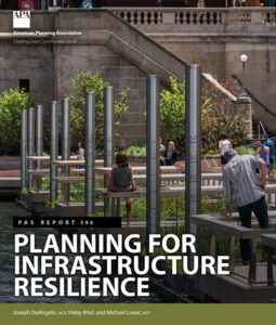
But the personal impact on me was to remind me to attend to an egregious oversight on my part that began earlier this year with the release by the American Planning Association (APA) of a new Planning Advisory Service Report, Planning for Resilient Infrastructure. I read it, attended to some other business in Texas and Nebraska in late February and early March, and along came the coronavirus, upending most of my existing personal and professional plans and refocusing my attention. But it is time for me to give this report the attention it deserves.

First, there is the question of why it deserves attention. The National Oceanic and Atmospheric Administration (NOAA), which funded the project led by the Association of State Floodplain Managers (ASFPM), which partnered with APA, chose their joint proposal in funding the first round of projects under its Coastal Resilience Grants Program in 2016. As Jeffrey Payne, director of NOAA’s Office for Coastal Management, states in his preface, “Tomorrow isn’t what it used to be. Increasingly, coastal conditions include all the risks of the past, but risks that are amplified by a changing climate, rising seas, and more rapidly fluctuating Great Lakes.”

In the interest of full disclosure, I was involved with ASFPM executive director Chad Berginnis in co-authoring the proposal for this project in the summer of 2015. (After I left APA, ASFPM hired me back as a consultant in later stages of the effort to help refine and focus the PAS Report.) Our intent was both simple and bold. Local governments spend tens of billions of dollars annually on the construction and maintenance of various kinds of infrastructure. Much of that infrastructure, related to essential services including water, wastewater, and transportation, is subject to the impacts of climate change. While, as Payne goes on to state, this is true away from the coast as well, some of those impacts are particularly significant and noticeable in coastal states and communities. In short, a great deal of taxpayer money is at stake regarding the ability of that infrastructure to withstand future climate conditions and natural disasters. Planning for greatly increased resilience is a recipe for improved fiscal stability. This holds true even if, as planned by statute, a greater share of that funding for hazard mitigation projects comes from FEMA through BRIC. Taxpayers are taxpayers, whether the money used is federal, state, or local.

All that said, the serious work of completing the work fell to Joseph DeAngelis at APA, now the manager of the APA Hazards Planning Center, and Haley Briel, a research specialist for the Flood Science Center at ASFPM, along with Michael Lauer, a planning consultant with deep experience in growth management programs in southeastern coastal states.

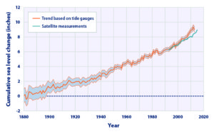
Global average sea level rise from 1880 to the present, based on tide gauges and satellite measurements (US EPA). Reuse courtesy of APA.

Their collaborative report addresses the most significant issues of infrastructure resilience. Particularly in areas subject to coastal storms, these involve not just the impacts of major disasters but the everyday nuisance impacts of flooding because of high tides atop sea level rise that already are yielding closed streets and parks and flooded basements. Urban flooding has become a “thing” where the term never used to be heard. They include a small table with projections by the U.S. Global Change Research Program showing ranges of sea level rise between 0.5 and 1.2 feet by 2050, and 1 to 4 feet by 2100. Of course, these are rough ranges in part because various geological conditions, such as erosion or glacial rebound, cause different results from one region to another, although most of the East Coast faces serious problems over the coming century. A major part of the problem is that sea level rise amplifies the impact of high tides in storms, leading to increased flooding and erosion that is already evident in low-lying cities like Norfolk, Virginia, or Miami. The authors note that, “Over the last half-century alone, with just one to three inches of average sea level rise, daily high-tide flooding has become up to 10 times more frequent” in American coastal communities. Even in Midwestern communities, including those along the Great Lakes, problems result from climate-driven increases in high-precipitation storms that frequently overwhelm stormwater drainage systems built in an earlier era based on other, less challenging, assumptions.

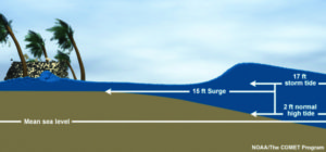
Storm surge heights are cumulatively based on the mean sea level, the height of the tide, and the high volume of water pushed toward the shore by coastal storms (National Hurricane Center). Reuse courtesy of APA.

It is natural that a planning document is going to assert a role for planners in addressing these problems. The role the report asserts is entirely logical, starting with “assessing long-term infrastructure needs and understanding future risks to infrastructure assets.” Equally logical, however, is that the report builds upon prior APA literature to outline the need for coordinated action through the plan-making process to integrate climate risk into local plans as a means of “capturing the future conditions to which existing infrastructure and any planned infrastructure projects will be subjected.” Put simply, if the local planning process does not identify those risks and provide clear recommendations for creating resilient infrastructure, it is not likely to materialize in any coherent and consistent fashion. The third chapter outlines a step-by-step approach (see illustrations below) for developing an inventory of local infrastructure, identifying risks, and moving toward an effective plan for adaptation.

The process for conducting an infrastructure vulnerability assessment (Joseph DeAngelis). Reuse courtesy of APA for both diagrams.


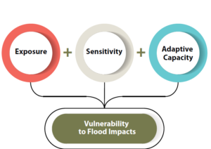
A project or asset’s vulnerability to flood impacts is a product of its exposure, sensitivity, and adaptive capacity (Joseph DeAngelis).

Later, the report provides some examples of what such consistent planning for resilient infrastructure may look like. Its case study of San Francisco’s approach to assessing sea-level-rise impacts outlines how the Sea Level Rise Committee of the city’s Capital Planning Committee (CPC), a body responsible for overseeing capital investments for infrastructure, recommended using the upper end of estimates from a National Research Council report for the West Coast. These were fed into a CPC guidance document for assessing vulnerability and supporting adaptation to sea level rise, a primary outcome of climate change. Without engaging the full details here, the bottom line is that the City and County of San Francisco was working from a single play book for climate adaptation of project life cycles for future infrastructure. Capital planning could thus proceed in a more standardized manner based on common assumptions. The report also uses an extensive example from Toledo, Ohio, the site of one of two pilot projects supported by the ASFPM/APA project. Toledo, sitting on the shores of Lake Erie, has suffered from stormwater flooding and is approaching the problem with a mixture of green infrastructure and analysis of social vulnerability in affected neighborhoods. The report elsewhere delves into questions and methods of documenting and addressing environmental justice and social and racial inequities in environmental protection through appropriate local capital planning projects.

Both cases highlight the value for local planners of establishing credible data sources, which often rest within federal agencies such as NOAA and the U.S. Environmental Protection Agency. But, as one chapter illustrates, these can include experienced national nonprofits as well, such as Climate Central. Unquestionably, however, the best single assemblage of data and tools is NOAA’s own Digital Coast website. Planners can access additional high-quality resources on climate through other NOAA programs such as the Regional Climate Centers, located at a series of universities across the nation, and the Regional Integrated Sciences and Assessments, where RISA staff work directly with climate scientists to communicate the science to the public and local officials.

Just as important as understanding where to find the proper data and tools, however, is a knowledge of best practices in local capital improvements planning, the development of effective standards, guidelines, and regulations for creating resilient infrastructure, and, finally, the best means for financing such long-term investments in infrastructure, especially with an eye to climate resilience. Each of these three topics is covered in separate chapters in the second half of the report.

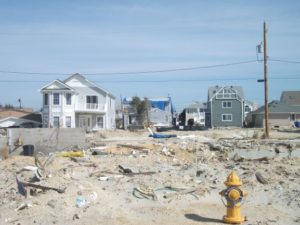
View of part of the Jersey Shore after Hurricane Sandy, February 2013.

Ultimately, the real challenge for local planners is overcoming a natural discomfort with the inherent uncertainties in planning for infrastructure that must withstand the impacts of climate change within a range of assumptions that, in part, depend on federal and even international action to mitigate rising global temperatures as a result of greenhouse gas emissions. Planners, and the communities they serve, must adjust to those uncertainties and the inherent complexities they embody. Planning, however, has always been a speculative enterprise riddled by uncertainties, yet cities have embraced assumptions about population growth, demographic change, and economic scenarios that have often been equally uncertain, for none of us has a crystal ball. What we do know, however, is the direction of existing and accelerating trends, and climate change is no myth. We are ultimately better off, and will better invest public resources, by anticipating climate change with the best projections available, so that our communities are not overwhelmed by future storms, sea level rise, and storm surge. We cannot say we did not see it coming. We can only hope to say we used a wise approach based on the best data available to avoid catastrophe for ourselves and future generations in the communities we serve.

Jim Schwab


Fatal Attraction

Explaining the frustrations of first responders in searching Mexico Beach, Florida, for survivors after Hurricane Michael, Brock Long, administrator of the Federal Emergency Management Agency, told Associated Press, “Very few people live to tell what it’s like to experience storm surge, and unfortunately in this country we seem not to learn the lesson.” Mexico Beach was ground zero for landfall of the hurricane a few days ago.

But then Long was much more direct: “When state and local officials tell you to get out, dang it, do it. Get out.”

The desire or willingness to “ride it out” among people who think the storm will never be as bad as they are told is unquestionably one of the most troubling facets of disaster response, especially when there is adequate warning.

There are disasters, of course, where adequate warning is either extremely difficult or nearly impossible. I still vividly recall one evening in 1979, when, living in Ames, Iowa, I was awakened from a second-story bedroom at about 3 a.m. by the loudest roar I had ever heard. I turned to the window to see total darkness, and aside from the howling winds, no clue of what was unfolding. When it finally passed, I went back to sleep. The next morning, I learned from the newspaper that a small tornado had struck about a mile away, lifting the roofs from seven homes before skipping off into the sky again. On the other hand, we had no cell phones and no reverse 911 in 1979.

Wildfires often give but a few minutes of warning, and earthquakes generally none at all. Hurricanes are different, at least today. In 1900, when more than 6,000 residents of Galveston were swept to sea in the deadliest storm in American history, they had no meaningful warning. In 2018, we have the best satellites the federal government and private money can buy, and we typically know at least 48 hours in advance that a coastal storm is coming, although its strength can change quickly. What we surely know in any case is that, if you live on the Gulf Coast or the Atlantic Coast in the U.S., you can expect hurricanes. Only the frequency and severity vary, and they are not always predictable. But people generally have plenty of time to learn what to do when the time comes. The rest is a matter of cooperation.

There is, of course, the question of why people choose to live in the most vulnerable locations. Early in my quarter-century of involvement in hazards planning, I borrowed

No question about it. The seashore can be a profoundly attractive place in calm weather. The question is both how we build and where we build, and, in the process, what burdens we place on first responders.

the title of a 1987 mystery thriller, The Fatal Attraction, to describe the psychology of our very human attraction to seashores, wooded mountains, and beautiful sunrises. Living on the seashore can be indescribably beautiful under blue skies and balmy breezes. There is nothing wrong with enjoying all that under the right circumstances, but it is critical that we begin to learn our own limitations in adapting to such environments, the need to build appropriately in such locations, and when it is time to simply “get out,” as Long suggested. If we don’t do these things, we are often placing inexcusable burdens on first responders who must dig our dead or injured bodies from the wreckage or save our homes from raging wildfires.

In short, there are times in life when we must be willing to think about more than ourselves. Saving our own skin in the face of oncoming natural disaster is not only not selfish; it is downright thoughtful with regard to the burdens otherwise placed on police, firefighters, and emergency medical personnel.

I am aware that the issue is bigger than I have just described. In another month, I will be speaking about post-disaster recovery to an audience of long-term care health professionals. As a society, we also have obligations to ensure that the elderly live in homes that are removed from floodplains and other hazards, that children attend schools that are as safely located as possible, and that we do not force the poor and disadvantaged into neighborhoods that are at risk and where no one else would wish to live. In New Orleans during Hurricane Katrina, the system failed thousands of poor people who did not own cars by failing to provide means for carless evacuation. The sheer number of such people was never a secret to officials in Louisiana, but good planning never happened before it was too late. All that said, those who have the means should have the willingness to consider both where they choose to live or build and to evacuate when told to do so.

We can all hope that the body count from Hurricane Michael remains low. As of the moment I am writing this, authorities have counted 17 deaths, but it may rise.

Long-term recovery awaits communities affected by either Florence or Michael. As always, serious questions can be posed about where and how to rebuild, whether we can make communities more resilient against future disasters, and what vision states and communities should have as they move forward. In its Influencers series, the Charlotte Observer asked what leaders thought North Carolina could do for coastal and inland communities affected by flooding from coastal storms. Interestingly, many cited setbacks from the coast, accounting for climate change (something the Republican-dominated legislature has explicitly chosen not to do), and keeping new development out of floodplains. All these efforts would make it easier to plan evacuations in the first place. The issue is whether North Carolina, or any other state in the path of such storms, can muster the political will to do what is right.

And whether people who live in highly vulnerable locations can heed the call when told to evacuate.

Jim Schwab


Initial Observations on Harvey

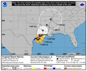
Map from National Weather Service. http://www.weather.gov/akq/Harvey

For the people of the Texas Gulf Coast, the rain and winds of Hurricane Harvey are just the beginning of a long journey. The storm will last a few days. The recovery will last years.
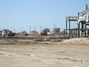
Destruction in the Bolivar Peninsula after Hurricane Ike in 2008

I am not there, so I can only surmise, based on the news coverage I have seen, the full extent of the damage and suffering that people are enduring in Corpus Christi, Houston, Galveston, and hundreds of other communities in a wide arc that has fallen under the impact of this storm. I do not even expect that people there will read this, certainly not right now. Nonetheless, it may be worthwhile to offer some insights to people elsewhere. I have never lived or worked in Texas, but I have been there numerous times and visited Louisiana more often than I can remember. I saw first-hand the devastation wrought in the Bolivar Peninsula and Galveston after Hurricane Ike. I have worked with people in Texas, including those at the Texas A&M Hazards Reduction and Recovery Center, over many years. They have educated me greatly on the vulnerabilities of their state.

With all due humility, therefore, but also with experience from other disasters over the past quarter-century, I offer some observations that may enhance what readers of this blog may learn from the news.
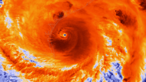
Photo from NOAA. The NOAA/NASA Suomi NPP satellite captured this infrared image of Hurricane Harvey just prior to making landfall along the Texas coast on August 25, 2017 at 18:55 UTC. NOAA’s National Hurricane Center has clocked Harvey’s maximum sustained winds at 110 miles per hour with higher gusts. Infrared images like this one can help meteorologists identify the areas of the greatest intensity within large storm systems, such as the areas with the most intense convection, known as overshooting cloud tops (dark orange), surrounding the eye and along the outer bands. https://www.nnvl.noaa.gov/MediaDetail2.php?MediaID=2086&MediaTypeID=1

First, this is apparently a somewhat unusual storm system. It approached the coast just northeast of Corpus Christi as a Category 4 hurricane, although it is now downgraded to a tropical storm. That does not make it less dangerous. The Saffir-Simpson scale that is used to rate hurricane strength deals only with wind speeds. Winds are certainly important, especially when they reach the 130 mile-per-hour range that was the peak for this event. Winds have, from all the visual evidence on the various news outlets I have watched, wreaked tremendous havoc along the coast, tearing apart buildings and overturning trailers and other vehicles. Moreover, hurricanes often spawn tornadoes, and some of the intermittent damage—that is, buildings ripped apart near others largely intact—suggests that this has occurred. In other words, if the more diffuse hurricane winds don’t get you, the tornado just might. It is no laughing matter. It is a wonder the death toll remains relatively low, although we almost surely don’t know the full tally just yet.

One specific impact that always accompanies coastal storms of this magnitude is storm surge, the waters pushed landward by the winds that in this case ranged from six  to twelve feet. These can do considerable damage in low-lying areas along the coast and may also exacerbate coastal erosion.

What makes the storm somewhat unusual also makes it dangerous even after being downgraded to a tropical storm. The storm system appears to have stalled a bit on Sunday and may even be backing out into the gulf for another landfall. At least two very serious consequences can flow from this. One is that the stagnant storm front will dump immense amounts of rain over consecutive days. The projected precipitation totals, even larger than what has fallen so far, mount up, so that projections for many communities range as high as 50 inches. Keep in mind that 30 inches is ample rainfall for an entire year in many parts of the country, and almost no city in the United States is prepared to absorb even half that amount in just a few days. The average yearly rainfall in Houston is just shy of 50 inches.

Moreover, as the storm moves back out over the Gulf of Mexico, it may regain strength that storms typically lose as they make landfall. Tropical storms draw their strength from the warmth of the water over which they pass until they make landfall, after which wind speeds begin to die down. The water of the Gulf right now is in the mid- to high 80s Fahrenheit, reportedly a full two to three degrees above average. That is the source of the strength of Harvey. Regaining any strength from the warm Gulf waters is not a good omen for the Texas coast, and as the storm moves slowly northeast, more of this will affect Houston than was originally the case. That is why we are seeing such intense scenes of flooding in Houston: The storm began with enormous amounts of moisture and has moved along the coast at a snail’s pace, at times just a mile an hour. As the week progresses, however, the storm is projected to move northeast over Louisiana and Arkansas, weakening along the way.

Of course, those warm waters raise questions about the influence of global warming, a topic that does not always receive a warm reception in Texas political circles. It is impossible to say that a specific storm like Harvey would not have happened but for climate change. It is also possible to say very credibly that warmer waters make stronger storms possible. Warmer waters can reflect seasonal and yearly variations, but over time they can also reflect climatic trends. For now, let’s leave it at that. People will have plenty of time later to debate this topic. In due course, as recovery proceeds, it should become a topic of reasonable, informed public discourse.

Other factors are at work as well. The sheer extent of flooding reflects the inexorable fact that the ground in any area has limited capacity to absorb rain. The hydrological cycle allows much rain under normal circumstances to drain into the ground, depending on the types of soil present in any given location. Sand absorbs very well but does not provide a very solid building foundation. Clay provides a better foundation but does not absorb water as quickly. Soil types matter, therefore, but in urban areas we have complicated matters greatly with large quantities of impervious surface that absorb little or no water by design. Impervious surface includes buildings (with the limited exception of green roofs), paved surfaces like roads, parking lots, and driveways, and other structural impediments to the movement and absorption of water. Houston is a very large metropolitan area with the fourth-largest population among major cities in the U.S. Although it is making strides, it is also far from the greenest city in America. Like most major cities, the percentage of impervious surface varies widely, depending on density levels in specific neighborhoods and corridors. Flooding is also influenced by the quality of the drainage systems; Houston is challenged in this respect by low-lying, flat terrain. It is criss-crossed with numerous bayous and canals that provide paths for the movement of water but also have serious limits to the water they can absorb before spilling over onto streets and highways. Those water-filled streets are the main obstacle to evacuation for those who stayed behind. There comes a point where people are better off remaining in place than trying to move, which is why Houston Mayor Sylvester Turner chose not to recommend evacuation.

Some dangers of mass evacuation for 6.5 million people are self-evident: clogged highways that are rapidly filling with water, producing death traps for people in stranded vehicles. Pedestrians cannot see steep drop-offs in elevation as they wade through high waters and can trip and drown. In Houston, the bayous may also contain alligators, water moccasins, and other wildlife hazards that are more easily avoided in dry weather. Moreover, the sheer volume of water can produce eddies and swirls that catch people off guard, and not everyone will be strong enough to regain their footing. Finally, flood water is always dirty water, sometimes just plain filthy, posing a potentially serious threat to public health.

All that said, many other major cities suffer from similar problems. I can think of no city that is prepared for the sheer volume of water currently falling along the Texas coast.

The Texas Gulf Coast communities, therefore, will emerge from this storm with a widespread pattern of both wind- and flood-related damage that will vary significantly from one area to the next, but collectively the costs will probably skyrocket into tens of billions of dollars. It is impossible to know the full costs just yet, but this will almost surely rank as one of the most expensive disasters in U.S. history. The recovery will take years of planning and implementation. If done well, it will involve a great deal of reassessment of patterns of development along the Gulf Coast and of the quality and importance of building codes. Social equity considerations will demand a new examination of the location and quality of low-income housing and the adequacy of affordable housing. Development regulations have seldom been politically popular in Texas, a state that still has never empowered counties to enact zoning codes. Some coastal communities may also wish to look more closely at the prospect of undergrounding utility lines to protect them from hurricane winds.

Events can push public attitudes in new directions. Part of that may depend on new lines of thought gaining traction in the discussion of rebuilding after the disaster. That may require some degree of courageous political leadership. Some very significant changes occurred in Louisiana after Hurricane Katrina, including consolidation of levee district management, adoption of a statewide building code, and a charter amendment in New Orleans that gave a new master plan more control over development regulations. We should not make perverse assumptions about outcomes, just as we also should not be naïve about the obstacles. But in my time at the helm of the Hazards Planning Center of the American Planning Association, we certainly worked hard to create a thorough blueprint for those willing to advocate better planning in response to major and catastrophic disasters, and I assume APA remains prepared to further that discussion and provide technical assistance where it can.

There will also be plenty of help available from the federal government, including the Federal Emergency Management Agency, the U.S. Department of Housing and Urban Development, and other agencies. We can only hope that Congress will sidestep much of its partisan bickering to ensure rapid allocation of the necessary resources. And we can hope that those resources and personnel are managed well to advance the recovery process, which is complicated and daunting.

One encouraging factor in the response has been the emergence of both willing volunteers and the effective use of social media to expedite search and rescue operations. The number of boats driven by volunteers rescuing people from rooftops and the interiors of flooded homes reminded me of the so-called Cajun Navy that operated throughout New Orleans in the desperate days that followed Hurricane Katrina. Disasters have a fortunate tendency in most cases to bring out the best in people, but we are also at a point in history where our new technologies facilitate the ability of willing heroes to find the people who most need help. Even the elderly and disabled are largely capable of dialing 911, or tweeting, or posting photos of their situation on Facebook, sharing their location, and pleading for help—and then finding their guardian angel at the front door with a motor boat. That is a huge advance from only a decade ago because it enables the willing volunteers to become effective heroes. If those civic and humanitarian instincts carry over into the slower grind of recovery, perhaps a stronger, more resilient Gulf Coast can yet rise from the mud, the grime, and the shattered buildings we see now.

Jim Schwab