FEMA Needs to Think about This One

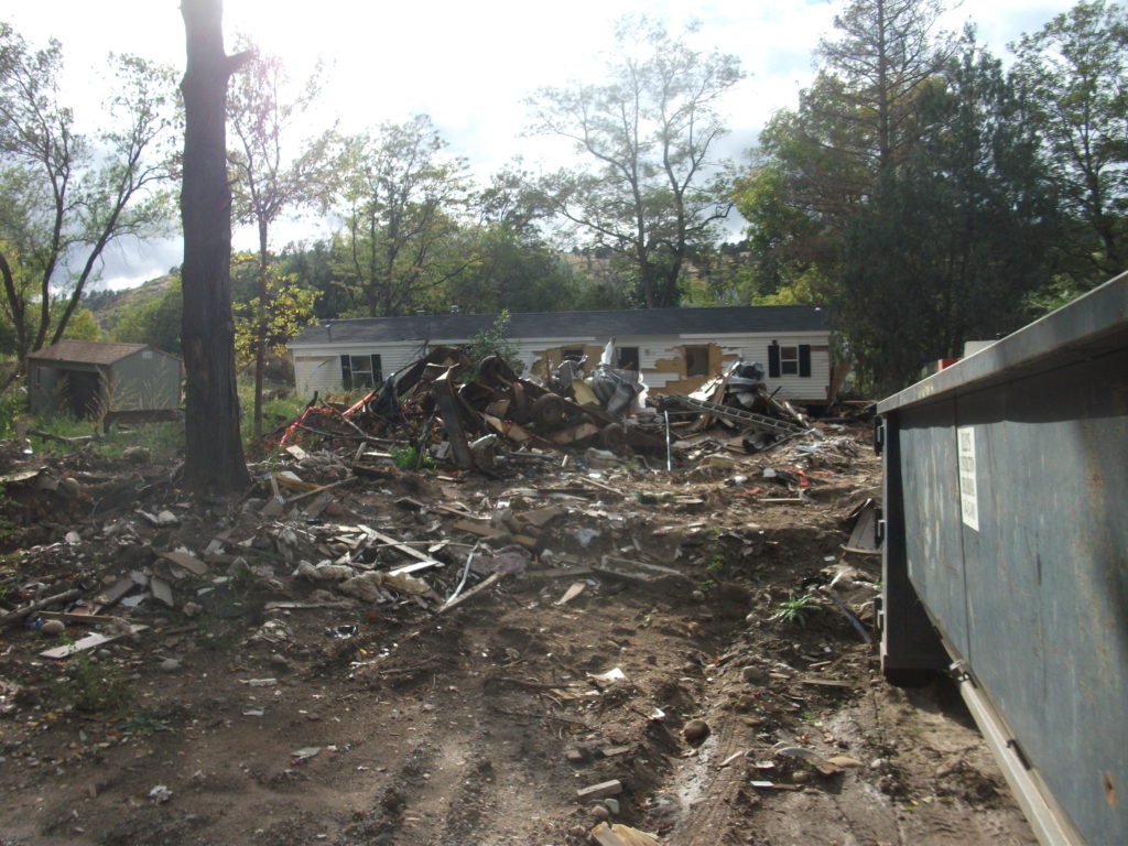
Flooded property in Lyons, Colorado, after the St. Vrain River flooded in September 2013.

There is that old saying that, if it ain’t broke, don’t fix it. To that, one might add that, if you’re thinking about fixing it anyway, you may want to clarify exactly how you wish to improve things and why you think the improvement will be better.

In a February 27 notice in the Federal Register, the Federal Emergency Management Agency (FEMA) proposed a major change in long-standing hazard mitigation rules regarding grants for acquisitions of flooded properties that made almost no effort to meet that test. I wish I had noticed it earlier because the deadline for comments was April 30. I submitted a brief comment on that date and tried to rally others on Facebook, but the truth is that this one got away from me. I was busy on other fronts. I have subsequently spent a few days gathering background information.

I am very glad that a few national organizations like the Association of State Floodplain Managers (ASFPM), American Rivers, and the Natural Resources Defense Council (NRDC) found time to file substantial objections to FEMA’s notice on Property Acquisitions and Relocation for Open Space (Docket ID: FEMA-2018-0006). Their objections raise profound questions about both the process and the substance of FEMA’s proposed changes. Others have also submitted comments.

Here’s the bottom line: For 30 years since the passage of the Stafford Act, which provides the basic framework of most federal disaster law, federal hazard mitigation grant programs have required that lands being acquired from property owners whose homes have been flooded must be placed into perpetual open space following demolition of the structures. The clear intent is to reduce the ongoing exposure of the federal government and the National Flood Insurance Program to repeated losses by precluding further development in those flood-prone areas. By and large, those grants go through state and local governments, which then maintain those open spaces and must periodically certify to FEMA that the lands remain in that status. Today, those grant programs include not only the Hazard Mitigation Grant Program (HMGP), a sometimes-substantial source of mitigation funding that is available after a presidentially declared disaster; the Pre-Disaster Mitigation (PDM) program, created as part of the Disaster Mitigation Act of 2000, which amended the Stafford Act; and Flood Mitigation Assistance (FMA), part of which deals with Severe Repetitive Loss properties, which make up a disproportionate share of overall flood claims.

In the notice, FEMA has announced a new option to allow owners of flooded properties to retain the underlying land while being paid to demolish the structures, thereby permitting them to eventually rebuild on that same flood-prone land. Because mitigation grants have gone from FEMA through states to local governments, those governments have been responsible for the open space programs that result. This new approach would allow the property owner the option of taking the grant directly from FEMA. In its comments on the proposal, ASFPM noted that, in the 2004 NFIP reform legislation, it supported providing FEMA the option to deal directly with property owners, mostly because some local governments have lacked the capacity to monitor the open space requirements, but it still expected that FEMA would consult with those governments before using that option as a means of maintaining consistency with state and local hazard mitigation policy. The current notice makes no mention of such coordination.

Elevation of flooded properties remains a viable option in many cases.

It is not as if these owners do not have other options for mitigating future flood damage, including elevation of residential structures above the 100-year base flood elevation established on FEMA flood insurance rate maps, or floodproofing the structure. But, the thinking seems to be, some owners will be more willing to demolish if they can retain the land. One possibility for some might be to retain the land, rebuild in due course, and flip the improved property while leaving the NFIP with continued flood loss exposures. How that helps federal taxpayers or other flood insurance rate payers is not especially clear.

The Federal Register announcement does nothing to make that clear. If you follow the link and read the notice, you are likely to experience my reaction, which was that I felt left in the dark regarding the rationale for making this move, which is not explained. Nor does FEMA provide any data to support the idea that this initiative would do anything to reduce flood losses. The opposite could easily prove true.

In an April 26 article in Insurance Journal, former FEMA administrator Craig Fugate offers some support for the new option by noting that placing land in permanent open space through a buyout is often a “hard sell.” That may well be, but it is partly because the solution is meant to be effective and lasting. It is also not as if the approach has lacked success. As NRDC notes in its comments, citing ASFPM case studies, more than 30,000 floodplain properties have been removed from development since 1993, many of them following major cataclysms such as the 1993 and 2008 Midwest floods and various hurricanes.

Perhaps more telling is the question of homeowners’ motivation in making the difficult decision to sell and relocate. The idea that people would necessarily prefer to be able to rebuild in the same location is not as clear or straightforward as some might assume, though there are, no doubt, advocates of property rights who would prefer to create the new option. But this emotional decision contains some factors that should not be ignored. Perhaps straight to the point is this comment from American Rivers:

Our experience working with floodplain managers has taught us that convincing property owners to accept a buyout is an emotional and difficult decision, and many are only willing to accept the buyout offer after they are assured that the property will be preserved as open space for the good of the public. Offering direct grants that allow new construction where a structure was demolished could be at odds with local hazard mitigation plans and efforts to acquire flood prone properties for open space. FEMA should instead be working to support the implementation of open space goals in local and state hazard mitigation grants.

In other words, many of those choosing a buyout, having suffered the damages of severe and repetitive losses from flooding, and aware of the larger issues concerning the public good in these situations, would rather ensure that nothing like this happens again, at least in their community. But what happens to the motivation undergirding their willingness to sell if they become acutely aware that their neighbors now have the option of prolonging the pain by not placing the land in permanent open space? Will they still feel that they are accomplishing anything by pursuing the traditional option? In any event, are these not the people whose choices we most want to honor for the greater good of the community?

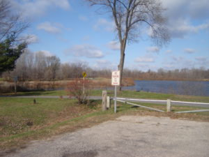
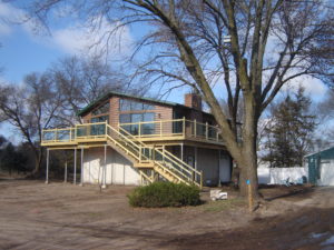
City-acquired open space in Cedar Falls, Iowa, near the Cedar River.

The essential reason all this is important is that we have learned much over the years about the natural and beneficial functions of floodplains, which include soil enrichment, wildlife habitat, reduced flood severity, and reductions in erosion and stormwater runoff, to name a few, in addition to the potential recreational functions of waterfront parks and open space. All this is in addition to the fiscal benefits of reducing future floodplain losses in the areas affected. If all that is not reason enough for FEMA to pause, rethink the question, and at least offer some solid scientific and economic documentation of the benefits of the proposed new approach, then I am not sure what is. Otherwise, count me a serious skeptic.

Jim Schwab

Riverwalk: A New Chicago Magnet

DSCF3110IMG_0239

Chicago is already quite rich in parks and tourist attractions. What can it add downtown?

In the past, I have written about the 606 Trail in Chicago, which is experiencing its first anniversary after opening a year ago. Despite some of its well-known challenges and problems, Chicago remains a city of quality destinations. Navy Pier, now a century old, just unveiled its redesign last month, including a new 200-foot Ferris wheel, and has been the top tourist attraction in Illinois. Millennium Park has few peers among downtown urban parks and has also been a second magnet for visitors since opening in 2004, ranking only behind Navy Pier.

But below the bridges and viaducts, down near the water’s edge, another jewel is nearing completion along the Chicago River—the Riverwalk. On June 2, I joined a tour sponsored by both the American Planning Association Illinois Chapter and the American Society of Landscape Architects Illinois Chapter and listened to an explanation of both completed and upcoming changes.

Chicago has no shortage of websites and museums devoted to its own urban history, which I won’t even try to summarize here. Suffice it to say that, when Haitian-French explorer-trader Jean Baptiste du Sable first encountered Potawatomi Indians (one of whom he married) at the shore of Lake Michigan in 1790, the Chicago River was still an indolent waterway barely crossing the sandbars to empty into the lake. In a little over 200 years, it has become home to one of the world’s largest cities, with all the pollution and navigation over two centuries that one might expect. In the 1890s, amid the city’s rapid industrial expansion, engineering reversed its flow away from the lake to the Mississippi River watershed, in large part to spare Chicagoans the pollution of their beaches and water supply that came with using the river as an open sewer. The river itself was not a place where you wanted to spend time unless you were in a boat, and even that was questionable. More than 800 picnickers died when the Eastland tipped over at the water’s edge in 1915. At street level on Wacker Drive, a plaque memorializes that notorious incident.

But times change, and in the 21st century, the Chicago River is once again a civic asset to which significant attention—and investment—are being paid. Over the last ten years, the first two phases of a rebuilding project have come to fruition, producing a Riverwalk that now extends on the south side of the main branch from Michigan Avenue west to LaSalle St. A third phase will extend the Riverwalk further west to the juncture of the North and South Branches. Even the term “main branch” may seem a little puzzling to non-natives because it extends only about one mile. Most of the length of the Chicago River is in the two branches, but the whole river in either direction is less than 20 miles. The Lake Michigan watershed in this instance barely reaches beyond the city and rises only about 20 feet above the lakeshore. Beyond that, you are in one of the sub-watersheds of the vast Mississippi River valley. Most people would never notice they had crossed this boundary if a sign did not tell them. The Continental Divide, this is not.

However, the controlled nature of the river and the short reach of the main branch make the creation of a downtown Riverwalk far more manageable and the experience of walking it thoroughly enjoyable. The firms of Jacobs/Ryan Associates, Sasaki Associates (with whom I have collaborated on disaster recovery issues), and Ross Barney Architects, involved in the design and engineering, have produced an experience that unfolds in “rooms” as one moves in either direction along the river, bringing users close to the water while allowing the occasional flood to muddy some steps without much damage beyond washing down the mud the next day. Phase 1redesigned and rebuilt an existing path between Michigan Avenue and the lake, an area popular with tourists as a loading zone below the stairs from Michigan Avenue down to the riverfront for tour boats. It then extended that two blocks westward to State DSCF3126Street and includes the Chicago Veterans’ Memorial Plaza, opened in 2006. One of its nice touches is a series of concrete stairs more suitable for lunch or relaxation than for climbing. It is a dignified but welcoming setting in keeping with its purpose. In Phase I, the idea began to emerge of adding river-level sidewalks that allow visitors to move from block to block without going up to street level and back down again, although some of these obviously had to intrude from the existing river’s edge into the waterway, and thus involved some negotiation among agencies responsible for navigation and safety, given the mix of water traffic still traversing the Chicago River. Congress also had to act to provide permission to allow building 25 feet into the river to create the necessary width for the new Riverwalk.

IMG_0242What has emerged in Phase II is the creation of the rooms: Marina, Cove, and River Theater, extending from State Street west. The first is opposite Marina City, occasionally nicknamed the “Corncob Towers” because of their design, and permits docking by river boats and lounging by pedestrians. The Cove, in contrast, is a favorite stopping point for kayaks and canoes, which provide a rich source of aquatic exercise for sports enthusiasts. The River Theater changes the nature of the experience yet again with the appearance of a riverside amphitheater, using a low-slope path woven into climbing stairs that can also double as points of relaxation for hikers. The theater, for the most part, is the activity on the river itself, although one can imagine a waterborne performance someday floating before the viewers. Most of this opened for public use just a year ago.

Phase III is adding a water plaza at the river’s edge; the Jetty, which places a series of floating gardens along the river edge that allow people to learn about river ecology and native plants, and the Boardwalk, providing an accessible walkway connecting to Lake Street. Although currently inaccessible at river level, one can view the construction on the final phase from street level. We were told the project will be completed by this fall.

O'Brien's is one of the existing restaurants, along with City Winery, that provide refreshment along the route.

O’Brien’s is one of the existing restaurants, along with City Winery, that provide refreshment along the route.

It is one thing to traverse this path with a crowd from a mobile workshop in the late afternoon. Not only does a crowd make a difference, so does timing. I returned the following morning, since my CTA Blue Line commute takes me to the Clark & Lake station. Instead of remaining on Lake Street, I walked to Wacker Drive and descended the stairway again, this time walking in the cool of the morning by myself at 8 a.m. Not that I was alone. The path was already being filled with pedestrians like me, and joggers, and even an occasional bicyclist, so I had to pay attention to those around me as I repeatedly set my camera to shoot many of the photos included here. Heat varies, of course, throughout the summer day, but one pleasant, enduring feature is the cool breeze off the water. In the morning, as well, the restaurants are not yet open, making for a slightly more solitary experience, which even a confirmed extrovert like me can enjoy in contrast to the crowds that by late afternoon are now finding their way to the

The collection of bars and restaurants on the Riverwalk is still growing.

The collection of bars and restaurants on the Riverwalk is still growing.

new bars and restaurants that are now exploiting the popularity of the Riverwalk, as intended, with more coming as the project moves along. The opportunity to sit outdoors at river level and enjoy snacks or dinner and drinks can be very pleasant, and very different from the usual experience high above on the city streets. I expect that most of these establishments will do quite well. I intend to enjoy some of them myself, with friends in tow.

Jim Schwab