Sobering Portrait of a Fiery Future


Summarizing the major points from a densely factual book like Firestorm: How Wildfire Will Shape Our Future, by Edward Struzik (Island Press, 2018), is about as challenging as understanding precisely what is happening in the midst of a rapidly moving massive wildfire. While California is not the focus of Struzik’s book, I might note that confronting such fires in November, such as we have seen on the news in recent weeks, ought to prod more interest in the recent National Climate Assessment and similar climate change science. The wildfire season most decidedly used to be shorter in California, a point Gov. Jerry Brown has made repeatedly. Put more bluntly, it is time to drop the political knee-jerk reactions and study the findings.

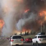
Horse Fire at Fort McMurray, Alberta, 2016. Photo from Wikipedia

In Firestorm, Struzik takes us north, much farther north. He starts his story by focusing on the utterly hellish nightmare of the May 2016 scene surrounding Fort McMurray, Alberta, during what became known as the Horse Fire, or among firefighters simply as “The Beast.” People with moderately long news memories may recall following this fire for several days and nights on television, as the fire swept through an area dominated by oil sands development, the heart of Canada’s energy sector. As Struzik notes, megafires (defined as exceeding 100,000 acres in size) are nothing new or unusual in the boreal forests of Canada and Alaska. Three fires bigger than The Beast had occurred in Canada since 1950.

Not so long ago in human history, however, the consequences would have seemed less catastrophic because of the lack of large human settlements in the area, which is not to say that such fires would not have affected native villages and smaller towns. But energy development has brought urban development, and Fort McMurray in 2016 was a city of 88,000 people. As the wildfire attacked and surged through the area, generating massive confusion, it destroyed an estimated 2,800 homes and buildings, burned nearly 1.5 million acres, and produced nearly $9 billion in total losses, including predicted insurance losses of $3.77 billion. The book does not state whether these are U.S. or Canadian dollars (worth about 10 percent less), but I am assuming U.S. given its publication in the states. Either way, it is a massive impact. It is certainly a staggering economic impact on a province like Alberta, home to such facilities as the Imperial Oil plant, which according to Struzik produces 220,000 barrels per day of the bitumen that helps fuel Canadian energy exports.

Much of Struzik’s book, which often starts chapters with quotes from Dante’s Inferno, tours us through the ground-level experience of the fire in and around Fort McMurray in early May 2016. We follow police who worry about family members evacuating, police who work door to door warning people to evacuate, hospital workers preparing for incoming casualties, and highways filled with bumper-to-bumper traffic including people in SUVs abandoning their vehicles in ditches after running out of gas, with the Royal Canadian Mounted Police (RCMP) ensuring that such people found alternative rides to safe destinations. Air tankers fly low over the fire to drop their loads of retardant, and helicopters scoop water from nearby lakes in 180-gallon buckets to disperse as strategically as possible. Wildfire response is no less sophisticated or expensive than in the U.S., although Struzik notes some Canadian pride in protecting firefighter safety and eschewing the “hotshot” approach that can lead to heroic but tragic deaths. He paints a realistic but deeply troubling portrait of the human elements of confronting a massive wildfire.

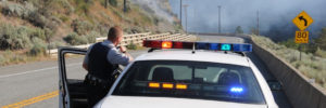
RCMP responding to wildfire in northern British Columbia. Photo from RCMP website

If such fires in the far north are not new, then what, if anything, is the impact of climate change? As has been pointed out many times, it is folly to link any one event directly to climate change, tempting though it may be for many people. The reality is more profound and concerning. Since the 1970s, in Canada, the area burned has doubled, with the prediction that it may double again by mid-century and possibly triple by 2100. In short, the connection to climate change is not any one fire, a natural phenomenon in a fire-adapted environment, but in increased frequency.

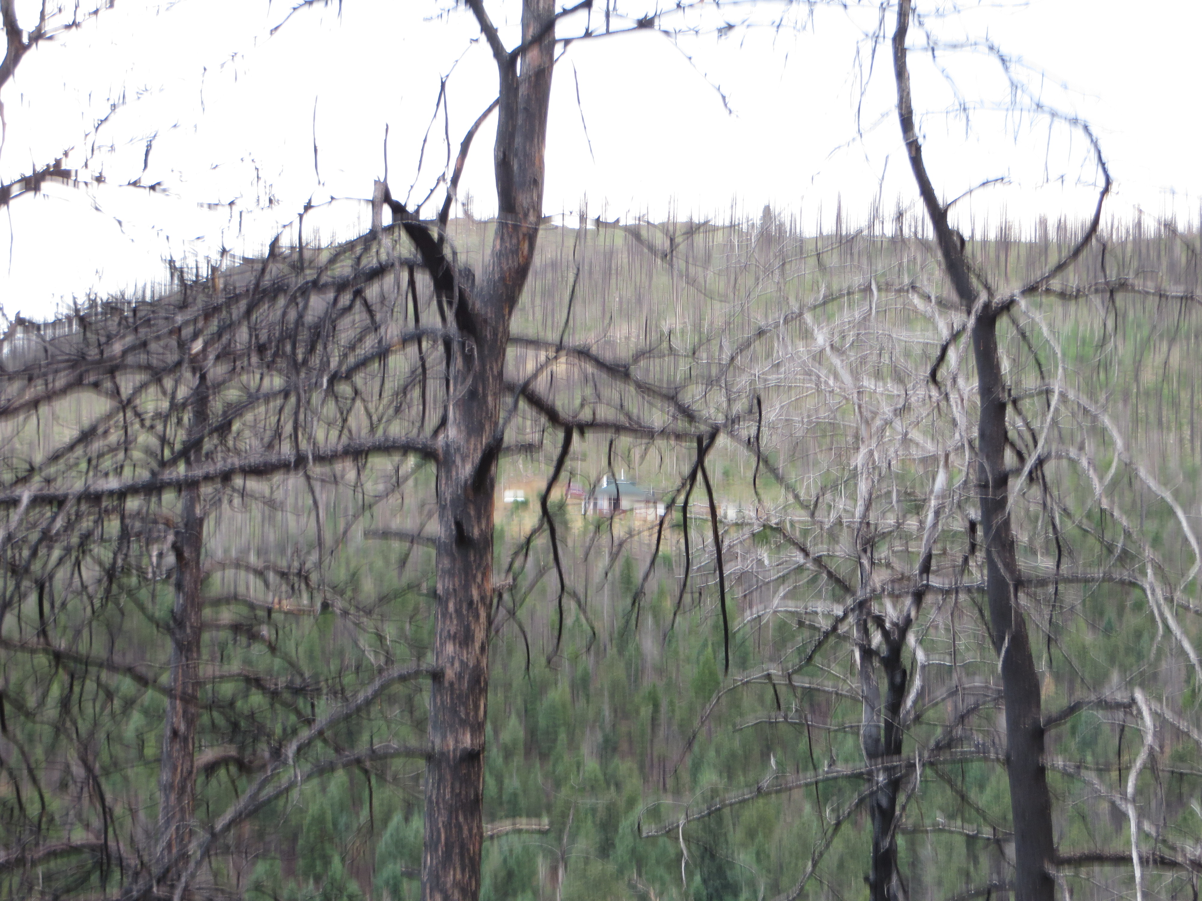
Ashes and devastation after the fire at Fort McMurray. From RCMP website

As California has learned, that frequency can also be abetted by a longer fire season, itself a product of climate change. Struzik explains the fire triangle, a combination of heat, dryness or low humidity, and oxygen. On May 3, 2016, the temperature around Fort McMurray was 91°F. The humidity was only 13 percent. For those unfamiliar with the boreal forest, it may be surprising to learn that such temperatures are not entirely unusual in the summer, even in Alaska, with much longer days than in southern latitudes, just as winter brings deeper freezes and very short days. It is a climate of extremes. But climate change is warming the far north faster than almost anywhere else, producing the loss of polar ice caps and the melting of glaciers. Montana, Struzik says, may see average temperatures rise by 5° F., and Montana has major wildfire issues already. Melting ice caps and glaciers are factors in sea level rise, which in turn affects major cities like New York and Miami much farther south, but Struzik notes that we are all connected in other ways to the fate of the northern forest. In a major wildfire like that in Alberta, air quality has been shown to suffer in places like Chicago because of the upper atmospheric drift of ashes and pollution. Northern Alberta may seem a world away, but it will never be distant enough to have no impact below the border.

Personally, I find the science behind all this intriguing, at all levels. Most people, for instance, may not know the origin of the term “firestorm,” which grew out of the cataclysmic 1871 wildfire in Peshtigo, Wisconsin, which took more than 1,500 lives, the deadliest in American history. The term refers to the behavior of lightning storms in pyrocumulonimbus clouds (aka pyroCBs), which involve an updraft “that sucks smoke, ash, burning materials, and water vapor” high into the sky. As these cool, they perform like classic thunder clouds. But a chemical reaction forestalls any rainfall, allowing the lightning strikes to stoke and expand the fire. The phenomenon remains a mystery and subject of intense study for meteorologists. It is also obviously terrifying and deadly for those beneath it.

Ultimately, in such a book, the question is what we are going to do about the problem. Both the U.S. and Canada have struggled to find appropriate ways to fund wildfire response and suppression, although it is clear also that more money needs to be directed to mitigation and preparation. Firefighting by itself is a completely futile approach. Struzik emphasizes a need in both nations to invest more in scientific research and in developing a “holistic plan” to deal with wildfires when they occur. The price of not developing a better approach, he says, includes the loss of clean water, of birds and animals who will lose their habitat as the problem intensifies, and the loss of jobs afforded by the forest environment. That research must inevitably account for the impacts of humanly generated climate change in coming decades, a task that should never be underestimated because, as one scientist notes in Struzik’s last chapter, keeping up with climate literature is like “drinking from a fire hose,” a curious metaphor in light of the problem. We must also be realistic. Nature has always provided for natural recovery because fire is a natural phenomenon, but it is the pattern of recovery that may change significantly in a changing natural environment.

Jim Schwab

Touching Sky and Sea in Norway

For three months, I have been intermittently aware that, back in August, I shared two phases of a trip to Norway that my wife and I took in July—and that I promised to complete the story with two more. At the same time, I was laying the groundwork for an entirely new phase of my career. Having left the American Planning Association (APA) at the end of May, I was planning book projects, establishing a one-person consulting firm, preparing to teach my fall course at the University of Iowa, and undertaking periodic speaking engagements. This was all part of my “five-point retirement plan,” of which the remaining piece is this blog.

Soon enough, however, given my professional focus on planning for disasters, real life overwhelmed my intentions. Even as I was laying the groundwork for Jim Schwab Consulting LLC, my consulting operation, Hurricane Harvey was blasting the Texas coast. Harvey was soon followed by Irma in Florida, then Maria in Puerto Rico, then wildfires in California. Though I have not been involved in recovery from Irma and Maria, people in Texas solicited my attention, and later I spoke at conferences in North Carolina and Utah. I am participating in a planning group for Harvey recovery, and I have undertaken some other work as well. Before I realized it, the semester was over, the holidays were upon us, and I had utterly failed to write about the rest of the Norway venture. And I do like to inject some travelogues into this blog. All disasters and policy disquisitions and no fun can make for a dull blog. (Some readers may disagree, but my mixture of subject matter seems to have broad appeal.)

Railway station in Oslo (Jean in foreground)

So. About four months ago, I left our story in Oslo after a busy Monday. Jean and I stayed overnight, packed our bags again, and got ready to travel to Bergen. The trip between those two cities is one I would recommend to anyone with the slightest appetite for dramatic scenery. But first we had to move from our hotel, the Radisson Blu Scandinavia, to the railway station. One truly neat feature of Oslo is the tram, which was included in our Oslo Pass, as was all other public transit including the subway system. The tram stopped right behind the hotel, and the railway station was only a few stops away. We had a pleasant early morning ride down the middle of the street, then crossed the street with our luggage and entered a very modern-looking station that would put us on our train to Bergen. It all seemed very convenient and well organized.

The train from Oslo to Bergen, however, is more than just well organized. Norway in a Nutshell notes that the Bergen Railway is “Northern Europe’s highest-altitude railway line.” The passenger cars indicate the altitude at each stop, so you can track your progress upward as well as across the country and downward again to the sea. The highest reading I recall was 1,224 meters, roughly 4,000 feet, but a glance out the window made clear the mountains around us touched the clouds at a slightly more rarefied level.

Once the train departs the urban environment of Oslo, the scenery changes rapidly, passing lakes and rivers and entering the interior of Norway to reveal small lowland farms in the shadows of green, often forested hills. Over a 6 ½ hour journey, the train finds its way into numerous small communities along winding valleys and into the mountains until you begin to witness snow on the peaks, even in July, where the combination of altitude and latitude make clear that Norway is never entirely green. Knowing the long history of this nation, one can only imagine how the challenges of traversing this landscape influenced first the Viking, then the medieval, Reformation, and even Enlightenment Norwegian mindset, and why the law of primogeniture combined with meager prospects for agricultural prosperity to send waves of young people to America in search of a better life. Of course, in modern times, Norwegians have found prosperity through other means, including energy development and a highly educated work force, but for many centuries most people endured a hardscrabble life in a relatively unyielding environment. That gorgeous landscape did not make life easy for those trying to survive by breeding livestock and growing crops. Even though we did not leave the train until we reached Bergen, one could feel the chilly air when the doors opened at small town stations, and knowing it was July made one wonder how cold it might be in January.

And yet there was no question that the views were strikingly beautiful–unless you were passing through one of several tunnels beneath the mountains. We were not there in the right season to attest to this, but I have read repeatedly that winds and snow in the winter make this mountainous terrain a challenging environment in which to maintain year-round train service. The Norwegians, however, are as prepared for such challenges as anyone. They keep the train moving.

In due course, of course, one reaches the peak of the journey, and the downhill ride begins, ending near the sea in Bergen, the second-largest city in Norway behind Oslo. Because of prior arrangements by Bill Mitchell at Conlin Travel, we were greeted upon our exit from the train by a local driver who turned out to be a retired police officer, a fact he revealed in the process of insisting that we buckle up before he took us to our hotel, about 15 minutes away along the harbor. From him, we learned that Bergen is a city of nearly 300,000 people, with half as many more living in the entire metropolitan area. As first-time visitors, we were about to learn just how much Bergen has to offer.

Our modest but well-appointed Clarion Hotel Admiral offered a marvelously serene waterfront setting, supported by a flotilla of sail boats, fishing boats, and larger commercial craft. Somewhere further along the coast were the large cruise ships, such as the Nordnorge, on which we would be sailing by the next evening. Bergen is largely defined by its status as a seaport on a fjord near the Atlantic Ocean, but that location makes it as scenic as any city would want to be. From a crowded waterfront, homes and other buildings seem to radiate up the slopes until they thin out and the insistent lush forest takes over. We were also lucky. We were told it had been raining for most of the month before our arrival, but that, with the emergent sunshine after some initial misty cloudiness, we had “won the weather lottery.” We were grateful for the photogenic result.

For Jean and me, after checking in and relaxing in our room, our first order of business was to meet up with personal friends who would join us on the cruise. Two of my colleagues at APA had also retired within the last few months. Carolyn Torma, formerly education director, left at the end of November 2016 and had already been traveling on her own since then. Deene Alongi, the meetings and conferences director, retired on July 12, just a few days before our trip. She and I had met over dinner about some business matters back in January, and in discussing our plans, discovered we both intended to cruise the fjords of Norway during the summer. She and Carolyn had already been making arrangements for a cruise with Hurtigruten, a Norwegian cruise company, through Mitchell, an acquaintance of Carolyn’s cousin, Carol Wargelin. Why not join forces, we decided, and book the same cruise? Using the same travel agent allowed us to connect at the same hotel, even though our three friends were arriving separately after flying straight to Bergen, letting us visit Oslo first on our own, something I wanted to do so that Jean and I could ride the train to Bergen.

In front of the downtown mall in Bergen. From left, Deene, Carolyn, Carol, and Jean.

By late afternoon, I met Deene in the lobby as she entered the hotel. Later we met Carolyn and Carol, and the five of us enjoyed dinner in Admiral’s very pleasant restaurant. Our conversation revolved around plans for the following day, for we would have until 4 p.m. to wander the city before boarding a bus to the dock to enter the cruise ship.

Although our plans evolved, Bergen made it easy to enjoy the day. We discovered the Kode museums, which line one edge of a charmingly picturesque public park anchored by a pond with a fountain but also including a gazebo and lush lawns. Using a single pass, we visited all four museums by late afternoon, punctuated by lunch at a reasonably classy diner adjoining one of them. The museums offer five daily tours in English, in addition to Norwegian. Kode 1 offers the Singer collection, a combination of Chinese porcelain, period furniture from the 16th and 17th centuries, and classic paintings, among other art, plus a splendid display of silver and gold artifacts created in the city over the past half-millennium, and the H.M. Queen Sonja “Underway,” displaying graphic and ceramic artworks sponsored by a royal who seemed to relish the chance to sponsor sculpture and craft works.


The silverwork section of Kode 1.

Kode 2 was not then open, preparing a new exhibition that opened in October. Kode 3 featured the Rasmus Meyer collection, an assortment of Norwegian paintings from 1880-1905, which is surely the golden age, with works from landscape and other

Part of the Rasmus Meyer collection.

painters like J.C. Dahl, Harriet Backer, and Theodor Kittelsen. I will not claim to be any sort of expert on the subject; in fact, I learned about some of the artists for the first time in this visit. But viewing these works up close filled me with admiration for their skills and the cultural perspectives they conveyed. There can be little doubt that Norway experienced a remarkable flowering of artistic talent in the late 19th century. And that is before we even mention the substantial display of work by Edvard Munch. The iconic The Scream, for which he is best known (and of which there are four versions), is only the beginning of Munch’s lifetime of productivity, punctuated by some tragic interludes that no doubt profoundly influenced some of his artistic idiosyncrasies. However, it would be a mistake to think that all, or even most, of his work is affected by the mental illness that ran through the family, including his father, or was dark and depressed. Indeed, there is an entire strain of cheerful nature painting within his oeuvre. Munch was clearly Norway’s artistic genius.

Finally, Kode 4 branches out beyond Norway to include numerous modern European and other artists, including Pablo Picasso, Paul Klee, Diego Rivera, and Joan Miró. But as one might expect, time ran out, and we all had to stroll back to the Admiral Hotel, retrieve our stored luggage, and await transport to the Hurtigruten dock to embark on our cruise, which will be the focus of the final installment in this series.

Jim Schwab

In the Valley of the Crooked River

DSCF3156Two weeks ago, I wrote about Cleveland’s Flats Entertainment District, where restaurants and bars now line the sides of the once filthy Cuyahoga River that now hosts boats and rowers. The Flats is but the last reach of a river that extends south into the Akron area. What has often been far less well known to outsiders than the more notorious industrial past of the river is the beautiful, forested valley that surrounds it upstream. In fact, about the time the Cuyahoga River was making environmental history by becoming a driving force behind passage of the Clean Water Act in 1972, U.S. Rep. John Seiberling, an antiwar Democrat from Akron, was leading an effort to designate a new national park. By 1974, he had won authorization for the creation of what is now the Cuyahoga Valley National Park, which remains a hidden treasure for many. I have personally discovered from discussing our trip that many people outside Ohio do not even know that the park exists.

For some interesting background on the politics and commitment behind the drive to create the park, I recommend a book I read several years ago about the life of John Seiberling, A Passion for the Land: John F. Seiberling and the Environmental Movement, by University of Akron emeritus history professor Daniel Nelson.

As for the Cuyahoga Valley National Park: Yosemite or Yellowstone it is not. Ohio, which became a state in 1803 and rapidly urbanized and industrialized afterwards, does not offer such massive public spaces for preservation. But it does contain gorgeous smaller valleys such as the Cuyahoga where protection of the landscape was still possible in the 1970s, and land was assembled from numerous small landowners and public spaces, woven in some cases into the fabric of the existing Metroparks system. In the area that contains the park, certain places seem to take one back in time to the 19th century, when Ohio built a canal to connect the Ohio River and Lake Erie and move agricultural and other products to markets a generation before the railroads began to dominate. Towns such as Peninsula and Boston, in the heart of the upper Cuyahoga Valley, still have the small town feel of that era in many ways, and many older homes have been preserved.

DSCF3157One, in fact, now hosts the Conservancy of the park, along Hines Hill Road just east of Boston, where one finds the visitor center. When we arrived, staffers were erecting a tent for an outdoor wedding that weekend. Curiously, we were also in town for an outdoor wedding for one of my nephews, but his was at Thorn Creek Winery in Aurora, several miles to the northeast. Although we merely stopped to investigate the scenery, and we were totally unexpected arrivals in the Conservancy office, the staff in the office treated us like honored guests, plying us with materials about the park and answering questions. Their friendliness is a tribute to the attitudes and sense of mission of both the Conservancy and the National Park Service itself.

DSCF3164The park itself is a fantastic playground for hikers, bikers, backpackers, and even skiers and sledders. This is the north, after all. Near the Boston Visitor Center is the Boston Mills ski resort, offering some modest hills but great accessibility for people in the metropolitan area. But we arrived in June, and we began to wander the Towpath trail that leads away from the visitor center back into the forest, south beyond the massive bridge that carries Ohio Turnpike travelers past the Cuyahoga River below. From the height of the turnpike, one might never realize that what lies below is a national park, although it is certainly an impressive expanse of forested greenery. Down below, however, we were treated not to nature’s silence but to its music. For one thing, it was cicada season, so the buzz was all about the woods, but so were the birds, some of whom may have been feasting on cicadas. We surely could have seen other wildlife, had we come around dawn or dusk, but we were hiking in the late morning, when the deer and the rabbits and coyotes were well hidden. It is remarkable how easy it is to get away from everything, although the trails are popular enough to keep you in touch with other passing humans. The trails seemed to attract both young and elderly, providing a great excuse to all ages to stay in shape and in touch with nature. I began to wish I had tree and bird guides with me to better understand parts of my experience. If I still lived in the area, I might revisit with those guides, but it may be a while before I return.

DSCF3169Our hiking visit occurred on a Thursday. Jean and I made a return visit on Friday, but of a different nature, and one that accommodated my sister, Carol, who lives nearby in North Royalton. She joined us at the parking lot on Rockside Road in Independence at 9 a.m. for the Cuyahoga Valley Scenic Railroad, a fine way for first-time visitors (and others) to see the park and its valley from a different perspective. The CVSR is a passenger train that uses tracks that largely run along the edge of the river. It is mostly run by volunteers who simply love the job of educating people about the local environment and its history. Audio is available that allows you to hear some of that history along with what one crew member jokingly referred to as “some pretty bad music,” most of it evoking a sense of bluegrass and Civil War and the early frontier with the use of banjos and bass fiddles. Call it “mood music.” The train ride takes about an hour and a half to get to Akron before turning around and bringing you back to where it started. Along the way, there are several stops that allow riders to get off and explore and then wait for the next train coming through. Explorers may want to get the schedule before they wander off. The price is only $15; as senior citizens we got tickets for $13. The money supports the train and is well worth it for the scenery along the way.

Because the park is interwoven among small towns and private property, the park leases some land for sustainable farming of vegetables and sheep, goats, and chickens, with some of the products finding their way to the Countryside Farmers’ Markets. The Conservancy staff also noted for us that there is now a visitor home in the park called Stanford House, built in 1843. It is not a bed and breakfast because visitors are on their own in sharing the use of a kitchen, but rooms can be rented starting at $50 per night, and the home provides immediate access to the Towpath Trail and the railroad, among other attractions.

Ultimately, the Cuyahoga Valley National Park is a study in adaptation, fitting a park into the scenery of a river valley that is also at the center of the large Cleveland-Akron metropolitan area. The park has been evolving since its advent in the 1980s and will continue to evolve as conditions change. But one major contribution it has already made is to stymie the urban sprawl that has so adversely affected much of the Cleveland area and allow residents to enjoy an expanse of refreshing greenery.

One reason it has taken two weeks to return to this blog and tell the story, since we returned to Chicago on June 12, is that I left again on June 19 for Grand Rapids, Michigan, to participate in the 40th annual conference of the Association of State Floodplain Managers, which was founded about the same time the national park was being organized. Today it is a growing organization of more than 17,000 floodplain managers, about 1,000 of whom attended the conference at the DeVos Convention Center, which sits along the Grand River opposite the Gerald R. Ford Presidential Museum, to which it is connected by a stone pedestrian bridge. ASFPM members have always been familiar with nature-based strategies for reducing flood damages and preserving the quality of rivers and streams, and the conference contained numerous discussions of such approaches. It occurred to me that what I had seen in the Cuyahoga Valley was one of the best possible approaches to floodplain management, the prevention of the encroachment of development to allow nature its due, preserving a natural setting that nonetheless endows humans with wonderful opportunities for outdoor recreation and exercise in an age when public health authorities worry about an epidemic of obesity. We have to make our cities attractive places for people to get the exercise they need. Many factors in the Cleveland metropolitan area, frankly, work against that goal, but the park exemplifies it. It is modern floodplain management at its best with a healthy dose of environmental protection in the bargain. The fact that the park is sprinkled with outdoor attractions like the Blossom Music Festival only serves to enhance that goal by acquainting people with what the park has to offer.

John Seiberling was clearly a visionary in fighting for the creation of the park in Congress. But every city has its environmental champions. It is the job of the rest of us to make it politically possible for them to survive and to achieve their objectives. We all benefit from a better quality of life when they do.

As for the title of this blog post: The Cuyahoga River derived its name from the local nomenclature of the Mohawk Indians, an Iroquois nation, who referred to the river as “crooked” because of the way it winds through the landscape, hence “crooked river.” (The Seneca, also Iroquois, used a similar name.) Meandering is nature’s way of diffusing the force of flood waters while distributing silt into the rich agricultural soils along the banks. Ohio grew up on such wealth. Now it is preserving some of it.


Jim Schwab

Greening Greater Racine

How often do any of us look around our communities closely enough to fully understand the extent of the greening activity that is taking place? My guess would be that the vast majority of us—and I include myself—have no idea of the sheer volume of hours and effort that is expended, particularly on a volunteer basis, to keep our cities green and healthy.

With Sandy and David Rhoads in the lobby of the Golden Rondelle Theater

With Sandy and David Rhoads in the lobby of the Golden Rondelle Theater

I had the opportunity this weekend to get a glimpse of all that effort in a city of about 80,000 just an hour and a half north of Chicago, in Racine, Wisconsin, a lakefront community about 20 miles south of Milwaukee. The gift to me was an invitation from David Rhoads to be the featured guest speaker for an event on Friday evening, March 18, which set the stage for an Eco-Fest the following day at Gateway Technical College. The evening event took place at the SC Johnson Golden Rondelle Theater, a building with a flying saucer appearance on the grounds of the SC Johnson Co. in downtown Racine. I should note that this company has for years sponsored environmental programs in and around Racine and provided backing through its Johnson Foundation for the famous Wingspread conference center, often used for important policy discussions related to environmental and resilience issues.

Inside the Golden Rondelle

Inside the Golden Rondelle

My theme was “Green and Healthy: The Future of Cities,” but I did not speak about Racine because, frankly, I did not know nearly enough about it, but also because my mission was to introduce the audience to the wider range of urban forestry and green energy activities around the nation. In the bargain, I discussed the role of hazard mitigation and disaster recovery planning in creating resilient communities that minimize the waste of destruction from natural hazards, concluding with the examples of Joplin, Missouri, which included major reforestation efforts in its recovery from a major 2011 tornado, and Greensburg, Kansas, which engineered a green recovery that has made the town 100 percent reliant on renewable energy. In short, my mission was to paint a holistic impression of what it takes to create green and healthy communities.

But David does know very well what has been happening in Racine, which was one reason he was introducing me that evening. We have known each other for nearly 25 years since he was a professor of New Testament at the Lutheran School of Theology in Chicago, and I was chairing the Environmental Concerns Working Group for the Metro Chicago Synod of the Evangelical Lutheran Church in America. David has always been intensely interested in the theology of creation and environmental stewardship. The Working Group mission became, and remains, financing and enabling energy efficiency and renewable energy retrofits for Lutheran churches in the synod, which covers four counties and roughly 200 congregations. David and his wife, Sandy, also a pastor, have made Racine their home and are actively engaged in environmental activism on the local scene, including faith-based environmental awareness efforts. I was thus more than pleased to honor David’s invitation.

Because the intent of my own presentation was to “set the table,” in David’s words, for discussing the greening of Racine, I was followed by a panel of four local professionals: Julie Kinzleman of the Racine City Health Department, who spoke on healthy beaches and water supply; Nan Calvert, on environmental education centers in the area; Matt Koepnick, on urban forestry; and the Rev. Bill Thompkins, an African-American church leader, on neighborhood beautification. Without detracting from the other three in any way, I must say I was particularly taken by Thompkins’s approach. After stating that his inner-city church had asked the question “you don’t necessarily want to ask,” namely, what would happen if your church were no longer present in the neighborhood, he and his parishioners and neighbors undertook to reclaim a city park that had become a gang battleground and began to distribute and plant thousands of plants and trees. What difference does that make? As Thompkins explained, people are more likely to treasure an attractive neighborhood than a neglected one, and to begin to take responsibility for their local environment. Greening the neighborhood, in effect, was a way of restoring the social health of the people in the neighborhood. That echoed a theme I had introduced earlier, citing our APA work in Planning the Urban Forest, that trees have actual mental health benefits that have been documented in social scientific studies. A city that is green is also a city that is healthy for its people.

But what also struck me was the diversity of the efforts underway, including not one but several environmental education centers in the area, and an ongoing expansion of tree-planting efforts in Racine. David asked me for a one-minute closing observation on the program, and that was the one point I chose to make. Look around. See how much is going on around you that you did not know was happening.

Activity at Eco-Fest Racine, at Gateway Technical College

Activity at Eco-Fest Racine, at Gateway Technical College

The entire program set the stage for a much better attended event the following morning at Gateway Technical College, a school on the lakefront that provides training in environmental technologies. Eco-Fest Racine featured more than 50 displays by groups large and small, activist and educational, including children’s activities, which attracted the immediate interest of my wife, a retired elementary school teacher. Display topics ranged from garbage disposal to recycling to energy audits to urban gardening and forestry to environmental education and advocacy. It included secular groups and Racine Green Congregations, where a woman named Margie informed me ruefully that Wisconsin, under Gov. Scott Walker, an ideological conservative, has been losing its best scientists from agencies like the Department of Natural Resources because of anti-scientific bias from the administration. In the space of just a few hours, neither my wife nor I could absorb all that was offered in this cornucopia of information, but I came to realize one thing: Such events serve a critical purpose in exposing all of us to the breadth of activity that is present in our communities. I do not think Racine is unique, though it is blessed. I think other communities might contemplate the model of this program, the first of its kind in Racine, according to David, as a way of connecting people.  We need to be more aware of the ways in which we support each other so that those at work improving their communities can feel less alone. Networking, after all, is an important form of empowerment.


Jim Schwab

That Burning Smell Out West

IMG_0224Although plenty of other issues have competed for our attention in recent weeks, astute observers of the news, in the U.S. at least, have probably noticed that wildfires have been charring much of the landscape in western states, most notably along the Pacific Coast. Both California and Washington are struggling under the burden of numerous fires triggered or helped along by prolonged drought and a hot summer. While some may jump to the conclusion that this is another harbinger of climate change, and it may well have some connections to climate change, it is important to know there are other historical factors that are even more significant. We have seen them coming but not done nearly enough to forestall the outcome, which may grow worse in coming years.

Ten years ago, in Planning for Wildfires (PAS Report No. 529/530), Stuart Meck and I noted that, in the 2000 census, the five fastest-growing states all had a high propensity for wildfires. Not much has changed. Texas, which suffered significantly from wildfires during its drought in 2011, made the largest numerical gain in the 2010 census, though it was fifth in percentage gain, behind Nevada (35.1), Arizona (24.6), Utah (23.8), and Idaho (21.1). Of course, many of those people move into larger cities like Las Vegas and Phoenix. More to the point, many people continue to move specifically into more rural areas with weaker development restrictions and building codes. As their numbers rise in what fire experts call the wildland-urban interface, the area where the built environment interfaces with fire-prone wildlands, so does human and structural vulnerability to wildfires. Why do people choose to live there? Social scientists, including some who work for the U.S. Forest Service, have been examining this question for at least two decades. We noted that the reasons include a desire for proximity to wildlife, privacy, nature, and the love of a rugged lifestyle.

These desires spawn problems, however, if not accompanied by considerable prudence in both how and where homes are built, as well as in landscape maintenance once a subdivision exists. Firewise Communities, a program of the National Fire Protection Association, has since the late 1990s sought to educate communities and homeowner associations on the realities of life in the wildland-urban interface, including the need for noncombustible roofing materials, eliminating a wildfire pathway to homes and other structures by maintaining a perimeter of “defensible space,” whose radius largely depends on terrain and forest conditions, and other best practices to reduce the impact of wildfires on homes. Still, we live with the legacy of prior development in many areas, and one result is that firefighters are increasingly exposed to lethal risks in trying to protect these homes when wildfire approaches. Every year some lose their lives, 163 over the past 10 years. There is a point where some homeowners must be told that more lives cannot be risked in protecting every remote structure at any cost.

And those costs are rapidly growing. Just 20 years ago, in 1995, the Forest Service spent 16 percent of its annual budget on fire management. That has climbed to 52 percent today, and the trend is ever upward, squeezing a largely static $5 billion budget of funds for other functions. About 90 percent of the firefighting expenses involve protecting houses. It would be a far simpler matter to let some fires burn, or to use prescribed burns to reduce flammable underbrush to prevent or mitigate future fires, if fewer of those houses were in the wildland-urban interface. But part of that fire management expense is for thinning the forest to scale back a problem the Forest Service itself created over the past century, and which modern fire managers have effectively inherited. Put simply, most of the western wildland forest is much denser than it was prior to the 20th century. Not just a little bit denser, but several times denser in many cases. The result is more intensive, longer-burning wildfires in those cases where the Forest Service is unable to suppress the fire at an early stage.

Full-scale suppression, however, is what brought us to this pass. Toward the end of an era Stephen J. Pyne has called the “Great Barbecue” (1870-1920), which saw some of the deadliest wildfires in U.S. history starting with the nearly simultaneous ignitions of Peshtigo, Wisconsin, which killed about 1,500 people, and the Great Chicago Fire, which had more to do with hot weather and conditions in the lumberyards that processed the products of the upper Midwest forests than with Mrs. O’Leary’s cow, the Forest Service secured its role as the nation’s wildland firefighting service. One can learn more about the Peshtigo firestorm in a great book, Firestorm in Peshtigo, by Denise Gess and William Lutz. That era was drifting toward an end in 1910, when the Big Burn killed 78 people and scarred 3 million acres and a pitched effort to fight them put the Forest Service in the limelight and won it this new role. Timothy Egan tells that story in The Big Burn. But the collective works of Pyne, an Arizona State University environmental historian who has specialized in the history of fire, can deliver more depth than you may ever desire and fill in the blanks between those two episodes and beyond into recent times.

What we have learned is that over time, as the policy of all-out suppression of wildfires took hold in the federal government, the smaller fires that historically and naturally had served to thin the forest were no longer allowed to do their job. The gradual result was a denser, thicker forest that, when it did catch fire, produces far more dangerous fires than ever before. When drought and bark beetle infestations begin to kill some of that dense forest, the result is that there is simply far more kindling than would otherwise be there. Yet, as Forest Service Chief Tim Tidwell notes, the Forest Service currently simply does not have the resources to undertake more than a fraction of the forest restoration work needed to achieve healthier, less fire-prone forests. The problem will only grow worse with a warming climate, of course, but did not arise primarily because of it, but because of past firefighting practices and a more recent history of development in wildland areas. But climate change can be counted on to produce increasing average temperatures that will vary depending on location, but possibly 4 to 6 degrees Fahrenheit by 2100. California’s Cal-Adapt has been tracking these changes and producing a stream of research and temperature maps that provide significant perspective on the extent of the problem we face moving into the future. It’s a sobering picture we would all do well to consider.


Jim Schwab

Restoring the Chicago Area Landscape

Outside the Thornhill Education Center, a view of the gorgeous grounds of the Morton Arboretum.

Outside the Thornhill Education Center, a view of the gorgeous grounds of the Morton Arboretum.

Chicago is not terribly old, as world-class cities go. It was incorporated only in 1837. The area was essentially devoid of European settlers until the 19th century. In the preceding centuries, the resident Indians, including the Potawatomi, had created a landscape dominated by oak ecosystems as a result of actively managing the landscape through the use of prairie fires. On the open lands of the Upper Midwest, there were few meaningful fire breaks, and the fires drifted east over vast grasslands. This North American fire regime changed the land by preventing the establishment of woody species, allowing oaks to dominate because of their thick, fire-resistant barks. The oaks in turn allowed more sunlight through their canopy and provided a thriving ecosystem for numerous species, including more than 800 species of birds and moths that eat their leaves.

The settlers who arrived in the 19th century, however, whether wittingly or otherwise, made quick work of the landscape they inherited from the natives they largely pushed out. They suppressed the wildfires in favor of plowing the prairie soils and savannas to create farm fields. Natural wildfires are few in northern Illinois; the wildfires that preceded European settlement were almost entirely a native artifact, which served the purpose of clearing hunting grounds but also served natural purposes of preparing the land for the sprouting of prairie plants. As the oaks receded, other trees moved into the void where fields did not prevent them, and in time maples and basswood took over, followed later by the invasive buckthorn, an introduced species. Today only 17 percent as much oak coverage survives as was present in the 1830s, and the landscape is highly fragmented. By the 1930s, only one oak-dominated parcel of more than 1,000 acres remained; today none remain. The numbers of various smaller chunks of oak land have also shrunk, just as steadily.

Chicago Wilderness, an alliance of organizations dedicated to open space, and the Morton Arboretum believe the metropolitan area needs to reverse the trend soon. Last August, I wrote about the Chicago Region Trees Initiative (CRTI) being led by the Morton Arboretum. On April 7, I attended a pair of meetings at the arboretum’s Thornhill Education Center that aimed at advancing the initiative. CRTI, which benefited for a period of time starting in the 1990s from federal support for some of its environmental projects, is now seeking new sources of funds as federal grants have waned, and is sharpening its focus into six areas of interest in order to clarify its mission for potential funders. Restoring oak ecosystems is one of those six focus areas. Another is landowners; most of the land that could be used to restore the fragmented oak ecosystems is private, and its owners must not only be willing to cooperate with the larger effort, but understand the reasons for it and its potential ecological, economic, and social benefits.

Economic and social? Yes. That is part of the appeal, one we laid out several years ago at the American Planning Association with the publication of Planning the Urban Forest: Ecology, Economy and Community Development, which began with an exposition of the documented benefits of the urban forest across dimensions of human health, pollution reduction, stormwater management, energy conservation, economic development, and other factors. Michael Leff, a research urban forester at the Davey Institute, has been developing a guidance document that stresses how good urban forestry needs to take a three-part approach that is as aware of the social and economic aspects as it is of the environment. Humans are essential to the success of any ecological plan, particularly in an urban setting. Public areas of nature or forest preserves contribute only a partial solution to a much larger problem, and solving that problem contributes significantly to human quality of life. It takes considerable scientific and social awareness to make the urban forest work in a highly developed setting where ecosystem fragmentation has become the norm.

Hence the social mission of CRTI: the need to share the story of the oak ecosystem with a wide variety of audiences throughout the area in an engaging manner that motivates them to take part in the initiative and participate in coordinated stewardship efforts. In addition, CRTI is reaching out to municipal public officials and staff, including planners, to provide training around the issues of municipal tree management and a model tree ordinance that CRTI is still developing for use by communities to advance the goals of urban forestry, including the oak ecosystem restoration efforts. There is also a role for the nurseries that grow trees and a need to keep them aware and involved so that they can be supportive of the overall effort, as well as for landscaping professionals, arborists, and others. I will return to this subject as the initiative progresses and evolves.

Meanwhile, I learned at the meetings of one valuable resource of which I was previously unaware: Bringing Nature Home, by Douglas W. Tallamy, published by Timber Press. So I looked it up, and it draws rave reviews for explaining the value of native plants and ecosystems, just as people at the meeting had said. It’s probably worth a download.


Jim Schwab

One Thing Leads to Another

I have been to my fair share of presentations on disaster-related issues. When I hear a particularly good presentation, I know it is good because I have a lot of others to which I can compare it. Sometimes local planners, emergency managers, and engineers, among others, can bring a certain parochial flavor to their presentations. I think this is usually the result of not having either the experience or the inclination to think beyond the set of problems and challenges immediately before them.

But there are also those who have thought bigger thoughts, figured out larger patterns, and validated them through observation and experience. Last week, at a conference in Broomfield, Colorado, north of Denver, I heard one such presentation that I thought gave listeners something serious to think about.

The Association of State Floodplain Managers, which is based in Madison, Wisconsin, was holding its Sixth Triennial Flood Mitigation and Floodproofing Workshop. I was invited to help present a 90-minute workshop on the integration of hazard mitigation into comprehensive planning, a subject I will address in a forthcoming blog. Before I do that, however, I thought it more important to discuss what Brian Varrella, an engineer and certified floodplain manager for the city of Fort Collins, Colorado, discussed in a plenary presentation based in part on his city’s experience with serious floods in September 2013.

Varrella did not settle for merely telling us about the extent of the flood and resulting damages in Fort Collins, and how the city is rebuilding again. He took the audience back to some neglected basics. In teaching graduate urban planning students about hazard mitigation and disaster recovery at the University of Iowa, I often try to do the same thing early in the course. I stress that all hazard events involve some very basic equation rooted in physics. Want a wildfire? Combine oxygen, fuel, and heat. Want to predict the direction of a flood? Think about gravity, and you will find the water, which inevitably flows downhill. Of course, the specific circumstances of any disaster require some knowledge of the local conditions, particularly topography, to make that understanding useful. But the basic equations never go away.

What differentiates a disaster from a natural event—what, for instance, turns a hurricane into a disaster—is the presence of the built environment and humans in the path of that event. A hurricane (typhoon) passing over an uninhabited island in the Pacific Ocean does not produce a disaster. The same storm assaulting Miami becomes a disaster. The difference is what we have built in harm’s way.

What if the conditions exist for several hazards simultaneously? That is the Colorado challenge that Varrella addressed. Wildfire, he noted, creates other problems from one disaster, in part by baking the soil when it is particularly intense. Subsequent thunderstorms cannot penetrate the now hardened soil, and instead carry vegetative and muddy debris downhill into the watershed, producing “muddy material that is opaque,” water that is heavy with silt. The result is a more intense flood. Colorado, Varrella noted, lost 10 people in last year’s floods; that was fortunately not even close to the record of 140 lives lost in the Big Thompson flood of the 1970s.

Yet some solutions commonly used to mitigate future damages elsewhere cannot always work because of Colorado’s steep terrain. Elevation, for instance, is commonly used in riverine and coastal floodplains to place the living area of a home above projected elevations of future floods, as determined by National Flood Insurance Program maps. But in mountainous terrain, watersheds can rapidly migrate in flash floods, washing out the toe of ledges beneath houses on hillsides. Elevation does nothing to restore the underlying stability of the soil, but significant setbacks from such ledges may help. Varrella suggested that Colorado borrow standards for such situations from other states with similar experiences, citing Vermont, New Mexico, and Washington. He noted that flood insurance rate maps (known as FIRMs) do not show all hazards. “We must find a new way of doing business,” he said. Maps that are static in time are not prone to show or predict such dynamic erosion.

It is always helpful when such a speaker has a set of recommendations for moving forward with a dynamic, complex problem, and Varrella did, so here goes:

• Create a framework for understanding wildfire and flood as cascading, related events.

• Reduce the human side of the disaster equation, for example, by requiring setbacks in the cases cited above.

• Treat wildfires as a prelude to the sequence of floods followed by erosion and debris.

• Change our hydraulic and hydrological practices to think in the fourth dimension of time; advocate for unsteady hydraulic models that reflect dynamic realities.

• Collaborate as a watershed among local governments. The watershed is the most efficient level at which to mitigate damages from wildfire and flooding; combine resources, stakeholders, and solutions.

• Communicate all natural hazards to the public. Establish flood warning systems before wildfires ever happen.

• Break the fire-flood-erosion cycle by managing forests as assets, not just resources.

• More helicopters, please; get eyes above the ground to see what’s happening on the ground in a timely fashion in order to save lives.

It’s a tall agenda, but a sensible one that is manageable if we focus on the problem. I think he’s clearly on the right track.

Jim Schwab

Trees for Metropolitan Chicago

Would you imagine that the trees in the metropolitan Chicago region provide compensatory value of $51.2 billion? This is the calculation produced through i-Tree, a free software program provided by the U.S. Forest Service to estimate tree canopy and the ecological services it produces for our communities. This is not a seat-of-the-pants calculation. There is a great deal of science behind it, as I have learned over the last two decades in interactions with the Forest Service and the larger professional community devoted to advancing the subject of urban forestry. There is a substantial technical literature these days about the benefits of the urban forest in terms of air pollution filtration, reduction of stormwater runoff, reducing soil erosion, reducing urban violence by providing a calmer, more pleasant environment, and enhancing real estate values. In short, trees have serious economic value. At the American Planning Association, we cited much of this research five years ago when we released Planning the Urban Forest: Ecology, Economy, and Community Development, a Planning Advisory Service Report we produced using a matching grant from the Forest Service.

The value of that document for urban planners has made it popular, and we have participated for several years at a national level in the Sustainable Urban Forests Coalition. But the important work on the urban forest occurs at the local and regional level. Think globally, but plant your trees locally.

A full room listens as Lydia Scott outlines data behind the Chicago Regional Trees Initiative.

A full room listens as Lydia Scott outlines data behind the Chicago Regional Trees Initiative.

It was a great honor, therefore, to be invited as one of about 100 participants to the kickoff meeting July 30 of the Chicago Regional Trees Initiative at the Morton Arboretum in Lisle, Illinois. The arboretum itself is the result of an environmental vision long ago by Joy Morton, the founder of the Morton Salt Company, who had a love affair with conservation—and put out serious money to launch the arboretum to prove it almost a century ago. I learned a good deal about this interesting man when reading a biography of him, A Man of Salt and Trees: The Life of Joy Morton, as a biography judge for the Society of Midland Authors’ annual book awards. The book was one of our 2010 finalists in that category.

Outside the Thornhill Education Center, a view of the gorgeous grounds of the Morton Arboretum.

Outside the Thornhill Education Center, a view of the gorgeous grounds of the Morton Arboretum.

Morton Arboretum is now leading this initiative with the help of numerous organizational partners and donors, nearly all of whom were present for the meeting, which lasted from 9 a.m. until 1 p.m., including a working lunch.

I will not go into the Regional Trees Initiative in great depth right now, but I intend to follow it more deeply in the future on this blog. Not everything is ready yet; an intended website is not yet up, the logo is still in development, and working groups are being formed. Lydia Scott, the director of the Regional Trees Initiative, appears to have a hard-working staff behind her along with solid institutional support. One of our group activities that morning was to sit at our respective tables and hatch ideas about what was most needed to make the initiative a success. Those ideas were added to a folding wall image of trees as branches, and then leaves were added with individuals’ names after we were asked what we and our organizations were willing to do to help. The people attending represented a variety of local governments in the area, regional organizations like the Chicago Metropolitan Agency for Planning and the Metropolitan Mayors Caucus, and educational and civic organizations.

What we learned over the course of the morning was the quality and distribution of information concerning the regional urban forest, which is decidedly uneven, leaving room for improvement through such an initiative. The city of Chicago, it turned out, had by far the best information concerning its urban forest, whereas in many other communities a more thorough tree census is still needed. But there are substantial resources to draw upon, such as “Urban Trees and Forests of the Chicago Region,” a Forest Service research report freely available online. The larger issues often relate to the uneven commitments, and distribution of resources, among the 248 municipalities in the region. A few have excellent plans for local forestry management, but many have none. There is room for both the U.S. Forest Service and the Illinois Department of Natural Resources to improve outreach with technical assistance, but there is also a burning need for an effective outreach campaign to educate both public officials and citizens on both the importance of the issue and the best means of moving forward. For purposes like that, the Communication Work Group is one of several the initiative has established to mobilize the resources of its many partners in the effort. That is why we were all there.

While I was busy in the meeting, my wife and two grandchildren were busy enjoying the arboretum. which includes some nice children's facilities and a cafeteria.

While I was busy in the meeting, my wife and two grandchildren were busy enjoying the arboretum. which includes some nice children’s facilities and a cafeteria.

I plan to return to this subject in the future as the initiative progresses, particularly as RTI rolls out its website and other communication tools. Regular followers of this blog know that I attach considerable importance to this subject as a key element in the quality of urban life. If you live in another metropolitan area, what’s underway there to pursue similar goals?


Jim Schwab

Trees in the Disaster Recovery Equation

For the last two or three years, if not longer, I have been engaged in an ongoing discussion with people from the U.S. Forest Service and the International Society of Arboriculture (ISA) about the role of trees in post-disaster recovery. Phillip Rodbell, an urban and community forestry program manager with the Forest Service’s Northeast office in Philadelphia, has been particularly diligent in pursuing the question of how we can better protect trees in urban areas from storms and other major disasters as well as how to reduce the loss of trees in the process of removing debris after disasters. Too often, in the absence of qualified arborists or other forestry professionals, the existing incentives for debris removal cause more, rather than fewer, trees to be cut down and hauled away than is truly necessary. The question is how to change that.

The fact that some trees, sometimes many trees, do in fact get blown down in storms, crushing cars and occasionally people, snapping utility lines, and blocking roads, fosters the false perception in some minds that trees are inevitably hazards in themselves. In fact, inadequate maintenance of the urban forest, including inadequate attention to those trees that really do pose hazards, creates problems that can be prevented with better municipal tree pruning cycles and pre-planning for more appropriate vegetative debris removal after big storms. However, local resources, including professional expertise, can be overwhelmed in a more catastrophic disaster such as a severe tornado or hurricane. The sheer number of trees blown down by Hurricane Katrina, for instance, was staggering, well into the millions.

Phil and I ultimately decided that, if the Forest Service could provide a modicum of money to help sponsor what we decided to call a scoping session, and if ISA and the American Planning Association (APA) could contribute more modestly to support the project, we could perhaps bring together a team of subject matter experts, representatives of relevant local, state, and federal agencies, and people from interested nonprofit associations, and we could foster a meaningful discussion of how to address this problem. In the process, we might help save federal, state, and local governments millions of dollars annually in avoidable debris removal costs.

This spring, we succeeded in bringing that package together and initiating a contract between the Forest Service and APA. The result was a two-day discussion held June 16-17 in APA’s Washington, D.C., offices, involving more than two dozen people, mostly in-person, but with a handful joining by conference call from remote locations in New York and Mississippi. A summary of that discussion, and the issues it addressed, is now available on the APA website, along with a bibliography of resources on the topic, and a series of briefing papers prepared by the invited experts. I invite my readers to check it out. To learn more, click here.


Jim Schwab