It has been a couple of months since I last posted a video of our progress in filming for Planning to Turn the Tide. That last article summarized our film efforts in Jacksonville, Florida, in September 2023, but we had another trip in the offing then, to the Texas Gulf Coast. In between, as noted in a January 1 post, I underwent prostate surgery on September 29, which required at least a month of rest and inactivity at home before venturing out again, in order to ensure successful recovery. But on November 7, I met up with videographer David Taylor at Houston Hobby Airport and we drove to Corpus Christi, where the annual conference of the Texas Chapter of the American Planning Association was getting underway. The new blog video presented here was filmed there but edited and produced later.
Devastation in the Bolivar Peninsula from Hurricane Ike, 2009
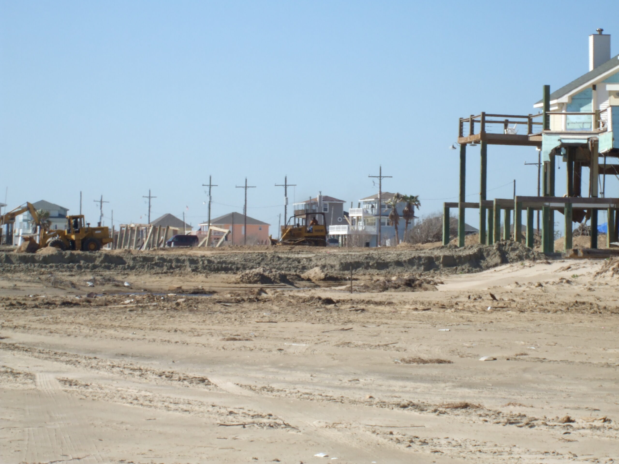
Despite my own challenges, what compelled this schedule was that conference at the American Bank Center in Corpus Christi because it allowed us to interview eight Texas planners who have been prominently involved in efforts to confront and address resilience issues along the Gulf Coast, where coastal storms and flooding remain major concerns. Hurricane Harvey, which struck in the fall of 2017, may be the most famous, and famously expensive, disaster of recent history in the area but is certainly not unique. People with a longer memory can cite Tropical Storm Allison, which struck Houston in 2001, and Hurricane Ike, which devastated Galveston in 2008, as part of the long parade of such events.
It is easy enough to cite shortcomings of the past that made destruction in such storms worse than it needed to be, but it is also important to note the resources that Texas has created to tackle those problems, including Texas Target Communities, a program at Texas A&M University that aids resource-challenged communities. These groups were present at the Texas APA conference, and we interviewed both Jaimie Masterson, the director of Texas Target Communities, and Shannon Van Zandt, a professor of urban planning at the Texas A&M School of Architecture, who has long researched and advocated for better affordable housing solutions in disaster recovery.
Tornado impacts in Van Zandt County, Texas, April 2017. Seven tornadoes struck the area in one evening.
I should also note that disaster resilience has been a consistent theme of the Texas Chapter. Back in November 2017, I spent time in Texas at the behest of the chapter, which asked me to facilitate and keynote a recovery workshop in Canton, Texas, following a series of tornadoes there, but I also worked with their Harvey Recovery Task Force well into 2020. The film trip grew out of that partnership, which extends even further back to my speaking at chapter conferences in El Paso and Galveston after Hurricane Ike. We want to thank the Texas Chapter for their logistical and promotional support during the conference.
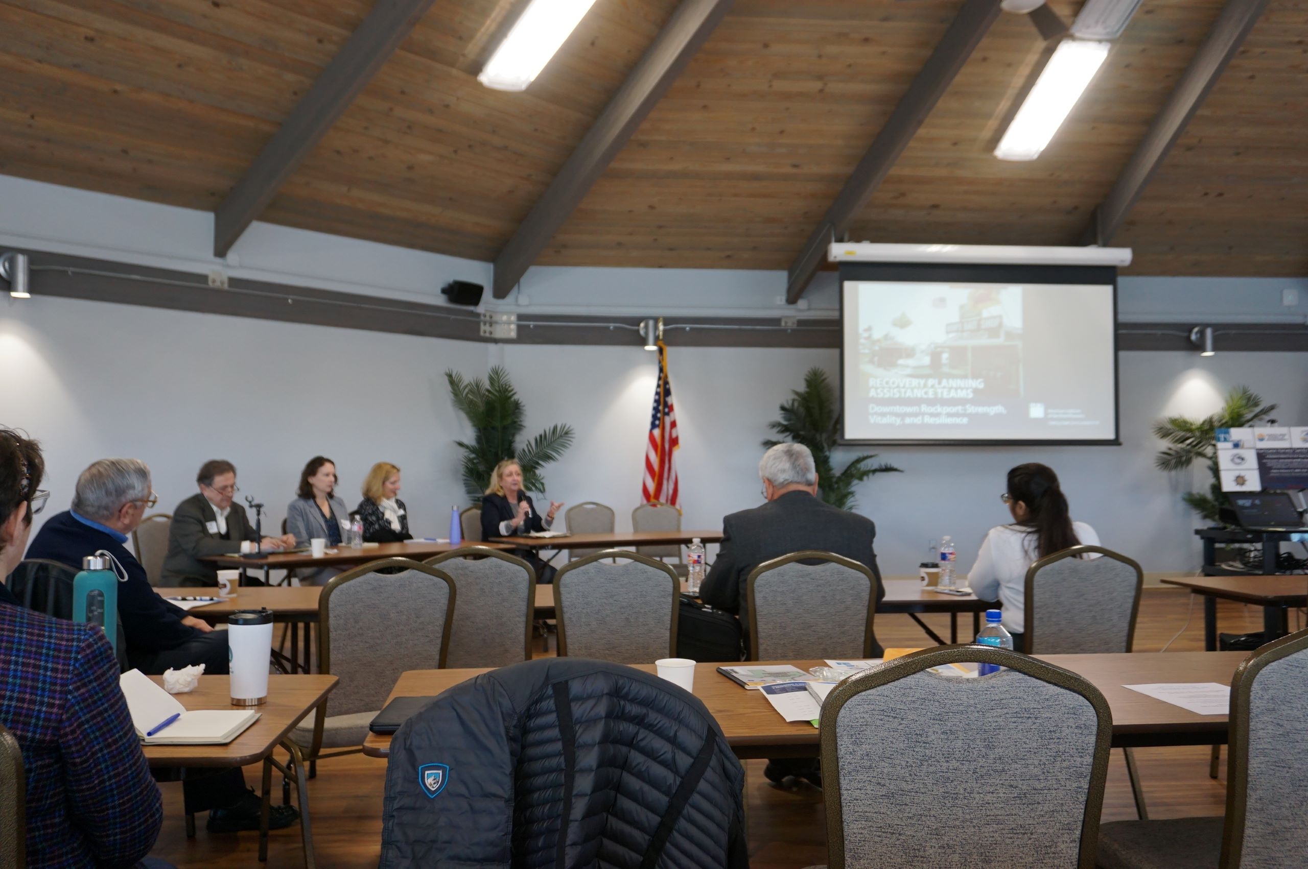
Peer exchange workshop in Rockport, February 2020, involving Harvey and Sandy recovery planners. Kim Mickelson, of Houston, with microphone, is moderating this session.
Following our time in Corpus Christi, we drove up the coast to Rockport, the site of the first landfall of Hurricane Harvey, where we interviewed four community leaders, including a city council member, the local newspaper editor, the public works director, and a former president of the local chamber of commerce, about Rockport’s experience in recovery. I have learned a great deal in recent years about Rockport, in large part because of my work with Amanda Torres, the former city planner there, now working for the Corpus Christi Planning Department, and Carol Barrett, a veteran planner now living in Austin, who led APA’s Community Planning Assistance Team in Rockport in 2019. They helped me design the Rockport case study for an interactive workshop, including both graduate students and practicing planners, that is part of a course I teach for the University of Iowa School of Planning and Public Affairs.
We ended our trip in Houston, which included a tour of largely Hispanic neighborhoods in the shadow of the city’s huge petrochemical complexes, where they face ongoing racially disparate environmental impacts. We were hosted on that tour by TEJAS Barrios, a local environmental justice advocacy group. We hope to return to Houston, but our challenge for now is to raise substantial money to try to complete the film project in the coming year. Fortunately, our core team has grown, with more hands on deck focused on fundraising. If you are willing to help, you can donate here or use the QR code below to contribute online at the APA website.
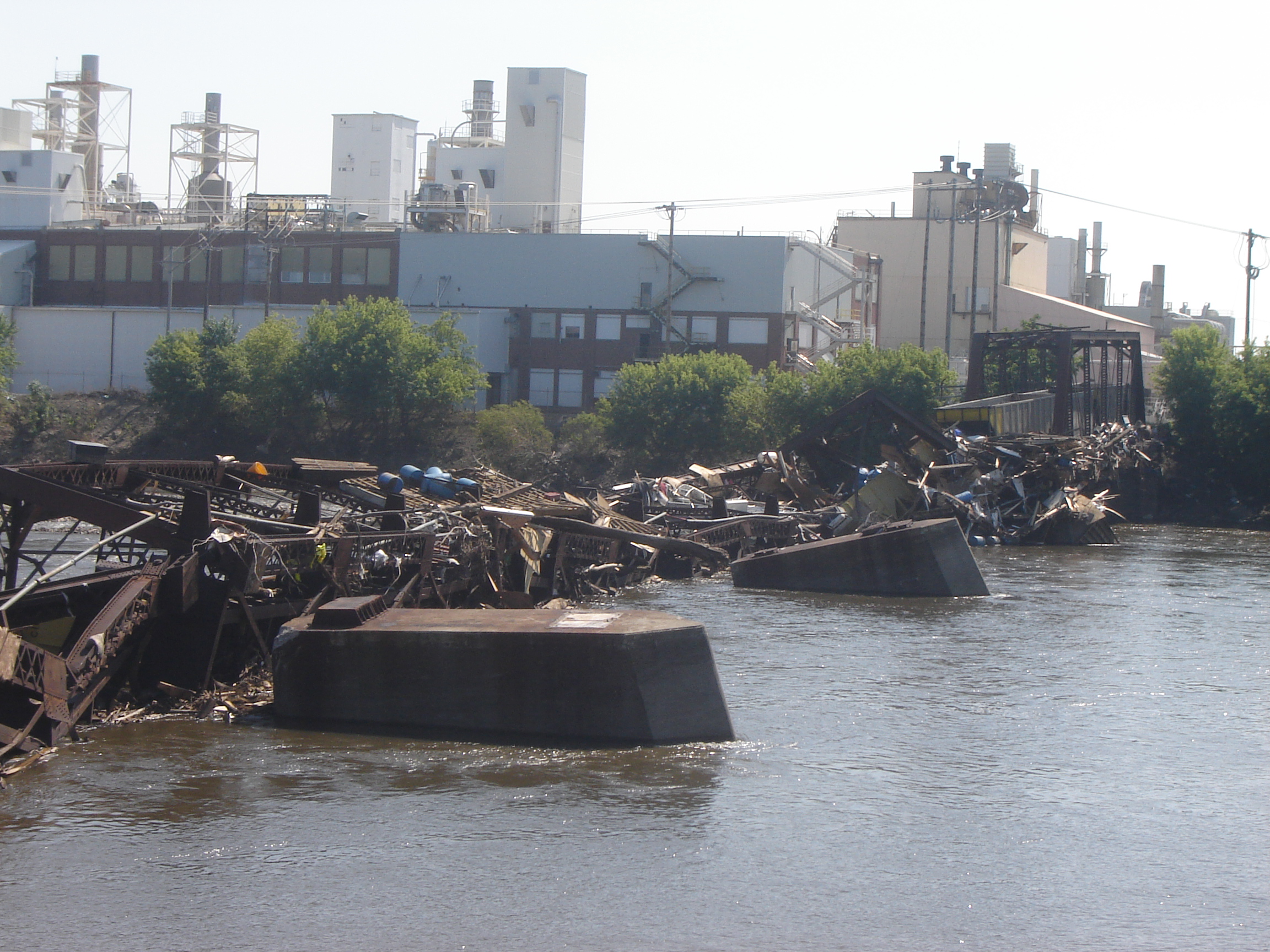
In the latter half of June 2008, it was hard to imagine Cedar Rapids as the city it had been just one month earlier. A massive flood along the Cedar River clobbered the city with a classic double whammy: About the time existing flood crests that had already swamped upstream Cedar Falls hit Cedar Rapids, a severe thunderstorm reached the city to compound the impact. The river, which runs through downtown in this city of 130,000 people, reached a flood level of 31.2 feet, besting the all-time previous record of 20 feet, reached in 1851 and 1929.
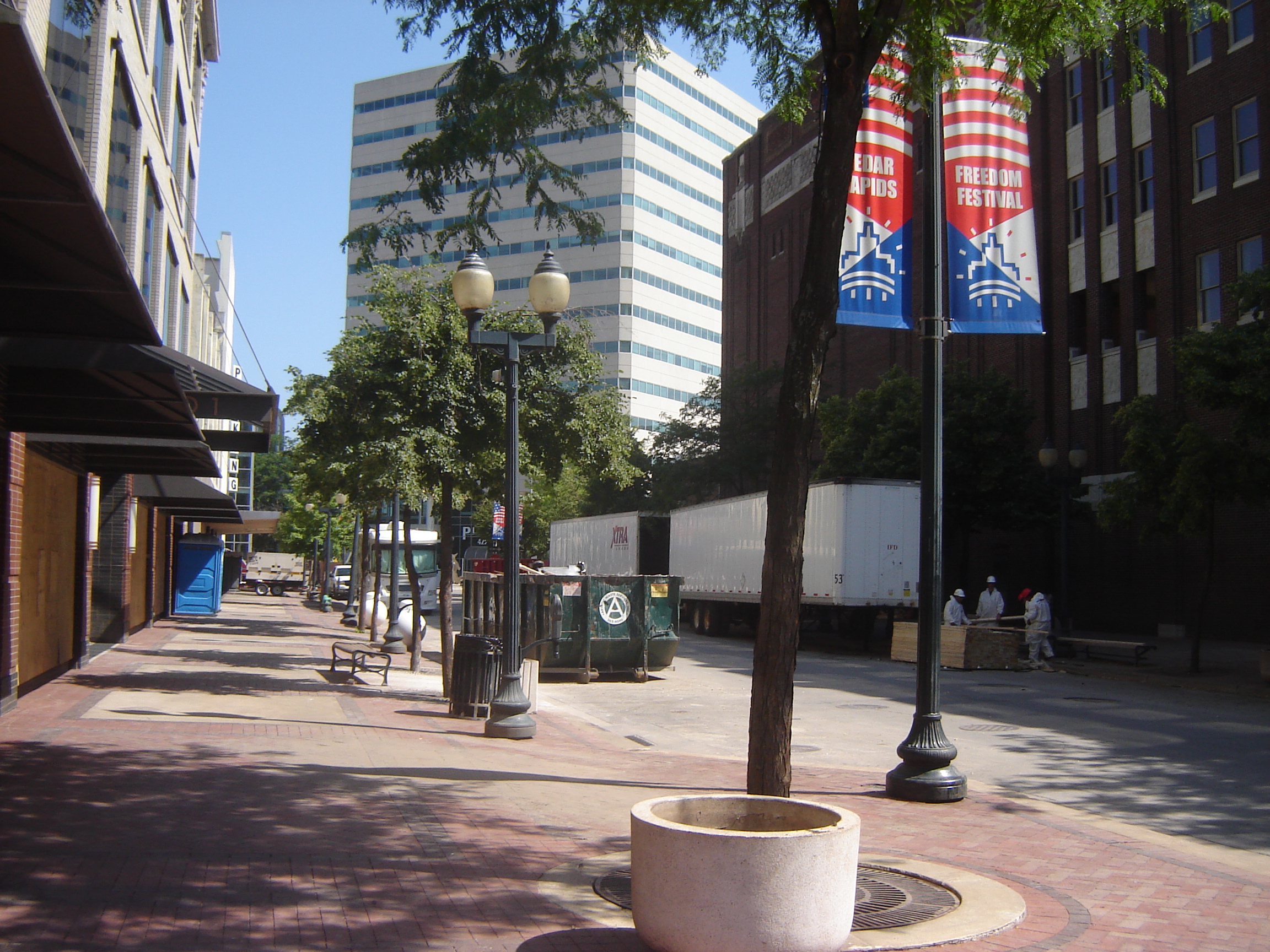
Downtown Cedar Rapids undergoing debris removal, late June 2008
Flood waters covered 14 percent of the city, more than 10 square miles. About 10 percent of the city’s population was evacuated from the deluge. Highway ramps became inaccessible, and at one point, a bus carrying prisoners from the county jail stayed just inches ahead of the rising waters to make its escape. City Hall, unfortunately situated on Mays Island in the middle of the river, was underwater, and governmental operations were moved to high ground elsewhere. In the end, nearly 1,300 flood-damaged homes were demolished, many making way for permanent open space as the city used federal hazard mitigation grants to acquire the properties with deed restrictions. Amazingly, as city officials have often said, there were no deaths due to the flood.
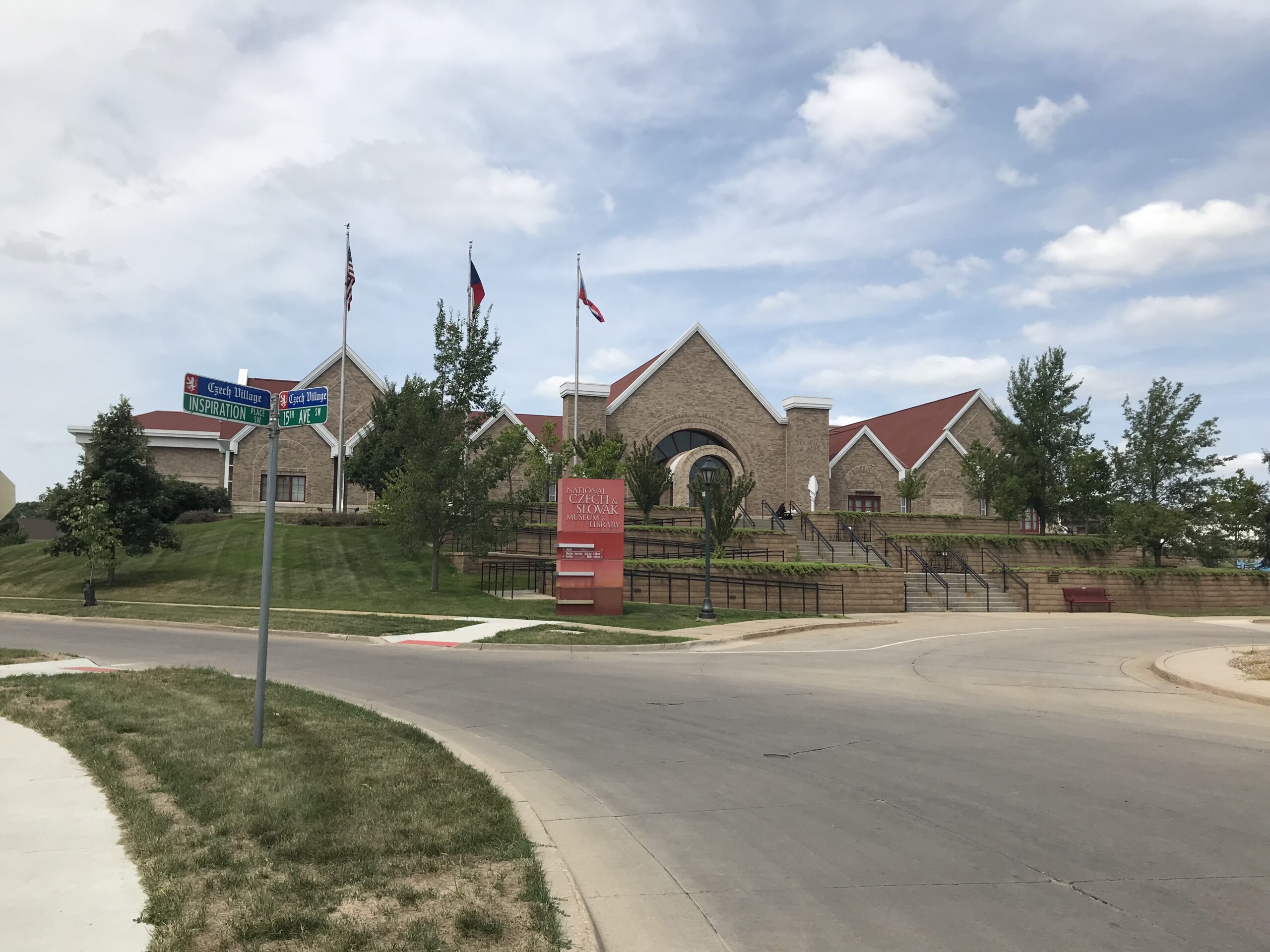
Relocated Czech & Slovak National Museum following June 2008 flood, Cedar Rapids
The avoidance of loss of life can be credited to the city and Linn County’s rapid response, which was not limited to emergency management. Within days, the Cedar Rapids City Council adopted a set of recovery goals that guided planning for long-term recovery for months and years afterwards. It shifted outside consulting contracts from riverfront planning to flood recovery. And it moved forward with a litany of creative approaches to business restoration, employment stabilization, and affordable housing development. Cedar Rapids became a living laboratory for community resilience.
Click here to hear two Cedar Rapids officials—Jennifer Pratt and Brenna Fall—discuss why they are supporting the HMDR film project.
These lessons have had lasting impacts in Cedar Rapids, which also suffered massive tree canopy devastation, as well as building damage, from an August 2020 derecho whose worst winds, exceeding 140 mph, swept through Linn County, including several suburbs. Taking climate change seriously, the city also last year adopted its own climate action plan. Cedar Rapids has quite probably done more to attack these problems in a forward-looking fashion than any other city in Iowa.
In coming weeks, this blog will feature new video clips from a four-day visit to the Florida APA conference in Jacksonville in early September. Meanwhile, plans are afoot for a November trip to Texas to capture additional content from the Texas APA conference in Corpus Christi, follow a mobile workshop exploring Hurricane Harvey recovery in Rockport, a Gulf Coast city where Harvey first made landfall in September 2017, and visit environmentally disadvantaged communities in the Houston area and record interviews with planners and activists there. Those posts will acknowledge the gracious support we are already receiving from several organizations and institutions in Texas.
To support the HMDR film-making effort, use either the donations link here or the QR code below. We will acknowledge all donors, whose help we greatly appreciate. Make this your film too as we move forward.
It was in this environment of concern about how Iowa would cope with future flood emergencies and disasters that the Iowa Legislature decided in 2009 to establish the Iowa Flood Center (IFC). Born of cooperative discussions between IIHR—Hydroscience and Engineering at the University of Iowa and state leaders, the Iowa Flood Center became a leading model for state technical outreach to communities regarding flood mitigation, flood awareness, and warning systems, including an extensive system of stream gauges. Centered at the Stanley Hydraulics Laboratory along the Iowa River, the Center manages the Iowa Flood Information System, a platform that gives communities across the state easy access to inundation maps, alerts, and real-time data on stream conditions.
It should be no surprise at this point that I decided early on that our film project, Planning to Turn the Tide, needed to include some content about the work of the Iowa Flood Center and the changes it has introduced to flood preparation and recovery in Iowa. On July 17, as David Taylor and I were making our way back east from Colorado, we stopped in Iowa City for the purpose of taping an interview with IFC Director Witold Krajewski, a veteran environmental engineer who has become intimately familiar with the hazard mitigation and planning needs of the hundreds of small communities, as well as larger cities, throughout a state that has seen more than its fair share of flood disasters. We also met with Kate Giannini, Iowa Watershed Approach Program Manager, about access for our film project to flood footage and other resources from the Iowa Flood Center that would help tell the story visually as well as in words.
Click hereto watch the blog video about our visit to Iowa City.
As always, if you wish to support the Planning to Turn the Tidedocumentary film project, use this link or the QR code below to access our donations link on the APA website. We can use your help and will truly appreciate the support.
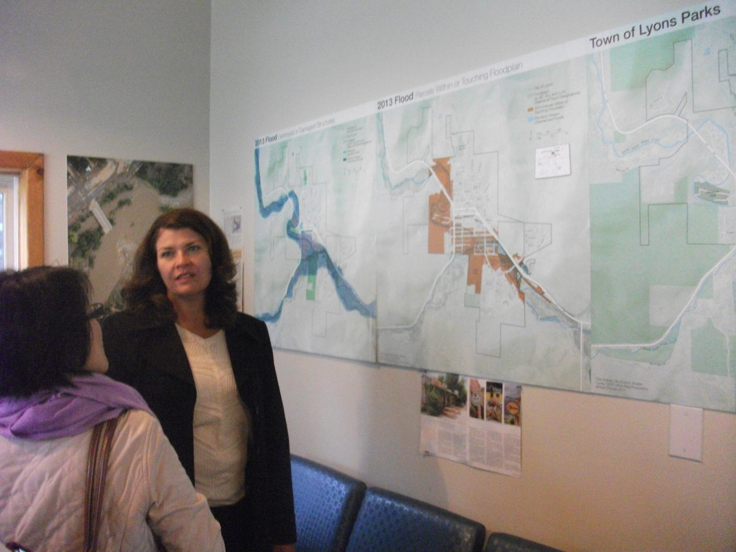
Victoria Simonsen discussing a map of the town’s flood damage with visitor, 2014
Ten years ago this month, Colorado faced a crisis. Following previous years of drought and wildfires, Rocky Mountain monsoon rains dumped a year’s worth of precipitation on the Front Range in a single day. Water poured down mountainsides that were sometimes so parched and scorched from previous high heat and fires that they could not absorb the rainfall, which then carried mud and debris downhill through the towns in its path. One of those towns was Lyons, which we visited on July 13 to interview Town Administrator Victoria Simonsen, who has remained on the job through thick and thin, helping to guide a remarkable recovery. But she also helped arrange for us to interview homeowner Priscilla Cohan, who is also a local artist, and Neil Sullivan, owner of the St. Vrain Market local grocery store. He has also served on the town’s planning commission, and his wife served two terms as mayor during the recovery.
Click here to watch the blog video recorded in Lyons.
I had previously visited Lyons twice in the early years after the flood, discussing some of the situation in an early blog post here. During the same time, a Community Planning Assistance Team (CPAT) from the American Planning Association spent several days visiting Lyons and producing a report with its own recommendations for moving forward. Lyons received other outside help too, from agencies like the Federal Emergency Management Agency, of course, but also from entities like the planning school at the University of Colorado at Denver.
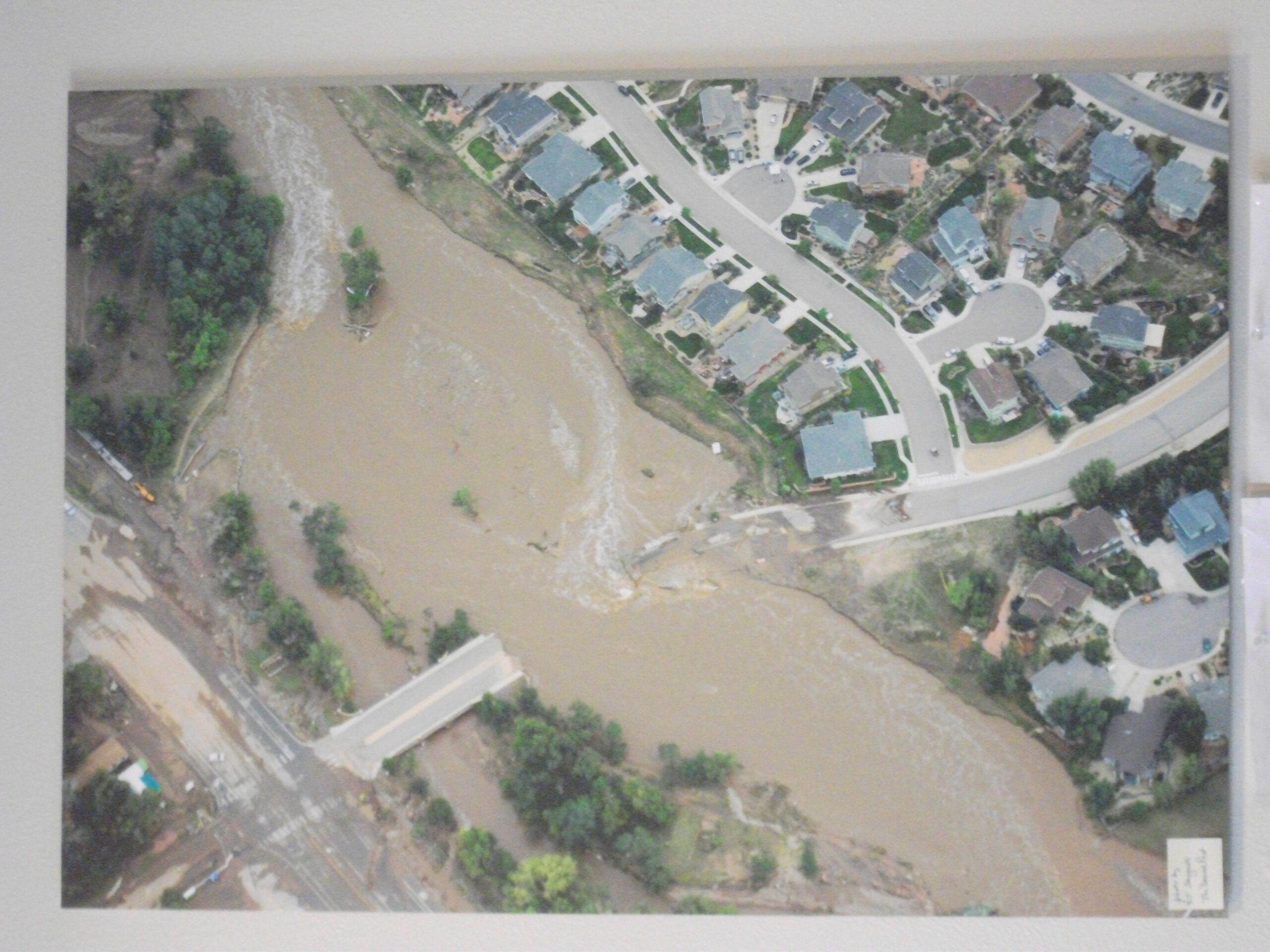
Aerial view of damage to bridge over St. Vrain River in September 2013
Now, the town is moving forward this month with a commemoration of that infamous flood that divided this Rocky Mountain hillside community into six islands divided by flood waters, compounding the difficulties of search and rescue until the flood waters receded. Why did we go there now? We wanted to capture this story and learn how it fit into a larger story of the State of Colorado building capacity for local governments to develop resilience in the face of cascading disasters like drought, wildfires, landslides, and flooding. We will integrate that story into the final film product for Planning to Turn the Tide, made possible by the assistance of people like Simonsen and numerous other volunteers from the Colorado APA Chapter and the Colorado planning community.
If you wish to support this endeavor, please use the QR code below or link here.
The view from this week’s brief video blog is from Chicago’s 606 Trail, but David Taylor, our videographer for Planning to Turn the Tide, and I were actually headed out on a much longer trail for nearly two weeks. In a car containing his video equipment, we departed Chicago on Thursday, July 6, and drove across Illinois, Iowa, and Nebraska to arrive two days later in Broomfield, Colorado, the site of the 2023 annual Natural Hazards Workshop. We returned to Chicago on Tuesday evening, July 18.
Click here to view this new video blog installment in our ongoing series.
Why such a long road trip for this documentary film of the APA Hazard Mitigation and Disaster Recovery Planning Division? We had long hoped that we could combine travel to Colorado and Iowa in a single trip. This project, dependent on grants and individual and corporate donations, does not thrive on an expensive news media budget. It is driven by a great deal of volunteer support from planners and supporters of the planning community across the country, and specifically by ad hoc groups organized in the locations where we have chosen to film segments that we think will be of the greatest educational and inspirational value in the final product. Part of the answer, therefore, lies in a diligent frugality with our donors’ money.
Flying is inevitable to some locations. In this case, however, an extensive network of grassroots contacts let us bring several elements of the production together in a short, concentrated time scale. First, we are extremely grateful to the University of Colorado’s Natural Hazards Center, which welcomed our operation enthusiastically at its conference at the Omni Interlocken Hotel and Resort in Broomfield, which took place July 9-12. Their embrace allowed us to film interviews at the hotel throughout the conference.
At the same time, support from the Colorado Chapter of the American Planning Association, as well as other volunteers, made it possible to arrange meaningful visits to communities along the Front Range that have been affected over the past decade by drought, wildfire, and flooding, and to interview people who could share their knowledge and experience, which will be detailed in upcoming blog posts over the next few weeks. That filled out the first week.
Over the following weekend, we made our way back east again to Iowa, stopping in Iowa City and Cedar Rapids to discuss some meaningful Iowa planning innovations at both the state and local levels, dealing mostly with floods but also larger implications of climate change. I will note here that, while we stayed overnight in Lincoln on this return trip, we experienced what I had already seen in Chicago two weeks earlier: significant air pollution sweeping through Nebraska as a result of drifting smoke from raging wildfires in Canada.
Chad Nabity
Little more than a week earlier, on our way out to Colorado, we had stopped in Grand Island, Nebraska, to visit on a late Friday afternoon with Chad Nabity, AICP, the planning director for Hall County and Grand Island. Chad is the sort of remarkable professional who loves to give back to his profession. He currently serves the American Planning Association as Chair of the Divisions Council, of which HMDR is a member. In our chat at his office in City Hall, as well as at a nearby chocolate shop, he discussed Grand Island’s encounters with natural disasters, which included some flooding issues but also the Night of the Twisters in 1980, when seven tornadoes visited Grand Island in rapid succession, devastating parts of the community and triggering frantic emergency response efforts. Chad himself was entering high school that year in Grand Island. Although his parents’ house suffered little damage, he says, “not the same for close friends of mine.” Later, Chad went off to college, earned his planning degree, and eventually returned as a Grand Island native in the position he now holds. Not surprisingly, Chad is also a member of HMDR.
The evening became famous enough to draw Hollywood attention, resulting in the first Family Channel movie production, titled, you guessed it, Night of the Twisters. The movie itself drew from a 1984 young adult book of the same name by Ivy Ruckman. I guess we are not the first to think of making a movie about disasters, but I confess to viewing most such movies with a jaundiced eye because of their tendency to sensationalize such events.
We are producing an educational documentary because we are more interested in telling the story of how to prevent or mitigate such hazards, how to create resilient communities, and how to persist in the long road to recovery that inevitably follows. We want to build a community of interest for better planning for disaster resilience.
If you think that is a worthwhile enterprise, I will once again mention our need for financial support. Use the QR code below or this link to help us out. We will truly appreciate it.
Like most people, I am not worried about the wrath of ancient pagan gods, but I had to wonder. It was just a week ago, amid the horrible air quality in the Midwest, including Chicago, that I told my wife that a good rainstorm might serve to clear the air of many of the particulate pollutants from distant Canadian wildfires. Visibility had been horrible, and Chicago was for two or three days ranked among the world’s dirtiest cities. Due to numerous variables, one must qualify what I said, but generally, rain can be expected to clear the air somewhat.
For healthy individuals, particularly those like myself without any serious respiratory illness, it was still easy to notice that breathing became a bit more strained during that air pollution emergency as fine particles from burning forests drifted through the region. For those with asthma, COPD, and other respiratory challenges, it must have been literally breath-taking to step outside. Those who could found ways to stay indoors, especially if air conditioning could help to filter air quality.
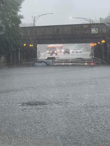
I mention the vengeance of pagan gods because I truly did not expect what happened on Sunday, July 2. It began early in the morning before dawn, maybe a bit before midnight in some places, but the skies opened up to produce record-breaking downpours. It was raining heavily by the time I woke up, around 6 a.m. It was still raining when my wife and I took our grandson to church. The windshield wipers never stopped, and we brought a large umbrella and wore raincoats. Afterwards, around 11:30 a.m., we left Hyde Park to head north along Jean Baptiste DuSable Lakeshore Drive to our home on the North Side, only to find the 47th St. entrance to Lakeshore blockaded.
Flooding July 2 near 95th St. on Chicago’s South Side. Photo by Greg Mathis
While the city was hosting NASCAR races on downtown streets over the weekend (not an event that I find worth the annoyance), blocking access at 47th seemed like an unlikely measure, so I assumed that it was done because the rains had flooded parts of the drive. (It turned out that it was closed for NASCAR, but it created other problems for us in avoiding flooded streets.) After all, cell phones were receiving warnings about flash flood emergencies throughout the area. Traffic was rerouted because of flooding on I-290, a major corridor in the metro area.
I had to find a series of detours to make our way home, with a stop along the way on Martin Luther King Jr. Drive at a Culver’s restaurant for lunch after Jean complained she was getting hungry. The rain almost never stopped except for very short intervals. Precipitation eventually totaled anywhere from three to seven inches for the day, depending on the location, with totals exceeding eight inches in some suburbs. Certain neighborhoods that face more significant problems with drainage infrastructure experienced flooded basements, most notably the Austin area that is home to Chicago’s new mayor, Brandon Johnson, who toured the area yesterday. Also hard-hit were some western suburbs like Cicero. More than a few people were driven from their homes or faced a great deal of potentially expensive work in cleaning up the mess and replacing some furniture and appliances. Businesses providing such services kept their employees on the job through the July 4 holiday, in part because delays can facilitate the growth of mold.
Much of the damage was further demonstration of a problem that has become known as urban flooding, in which high-precipitation storms that are becoming more common as a result of climate change interact with urban areas whose drainage systems are not designed to handle them. This also introduces an environmental equity problem because many of those neighborhoods are older areas with high percentages of minority and low-income populations. This poses a serious planning challenge for cities like Chicago as they seek to remedy such inequities.
It has been twelve years since Mayor Rahm Emanuel dismantled the Chicago Department of the Environment that had been created under Mayor Richard M. Daley. One-term Mayor Lori Lightfoot had originally promised to restore it, but never did so. Now, Mayor Johnson has pledged to reestablish it, and this series of events may well push him hard to adhere to his promise. He said as much as he spoke about the challenges on Monday, July 3. A political science major as an undergraduate, I am not naïve enough to believe that recreating the department will solve all of Chicago’s many environmental problems, in part because mayors will come and go and priorities will change, but it cannot hurt for now to build some sort of political momentum behind whatever mission it is given. Based on Johnson’s statements so far, one could reasonably expect that climate issues would be high on the agenda. But we shall see. Actions speak louder than words.
But certain words matter because they frame the problem being addressed. According to the Chicago Tribune, Johnson told reporters, “Literally, the earth is speaking to us loud and clear, where extreme weather is taking place all over the country. . . . [T]his is not likely the last extreme example of weather.”
It is time to roll up our sleeves. It is time to debate solutions, not the reality of climate change. In Chicago, at least, that is no longer much of an issue. The issue is what we aim to do about it.
Click hereto watch the summary video about the interviews at Tampa Bay Regional Planning Council.
One of our interviews featured Jerry Stickney, Director of the Sunshine Line, a Hillsborough County agency that provides transportation for disabled and disadvantaged people, including special services during natural disasters. That last point provided the bulk of our discussion because evacuating and sheltering these people during hurricanes, major storms, and other disasters is a major responsibility, but one that ensures some degree of social equity in the face of life-threatening circumstances. Hurricane Ian could easily have become the major hurricane that finally invaded the Tampa Bay region but instead turned east further south, striking the Fort Myers area.
Cara Serra, resiliency planner for TBRPC, discussed her role in facilitating the work of the Regional Resiliency Coalition, which consists of several working groups examining regional issues concerning shoreline management, infrastructure, stormwater management, and resilient building design and land use, among other concerns. They are currently developing a Regional Resiliency Action Plan.
In the quest for regional resilience, learning lessons from disasters elsewhere plays a major role, one that has not been neglected. Sarah Vitale, planning director for TBRPC, led the development of a new iteration of Project Phoenix, originally created in 2009, to help business leaders and others in the Tampa Bay region understand what the impact of a Category 4 or 5 hurricane might be if it took aim directly at Tampa Bay, something that last happened more than a century ago, when the population was barely one-tenth
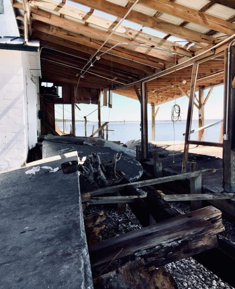
Damage from Hurricane Michael, Bay County, FL. Photo by David Taylor
of what it is now. Her training workshop includes video clips of both a simulation of such a storm and real-life stories from Mexico Beach of economic recovery from Hurricane Michael, which struck the Florida Panhandle in October 2018.
Finally, we also spoke with Sean Sullivan, the executive director of TBRPC, whose engaging New England accent kept us captivated as he outlined his vision for a six-county region that is aware of its risks and prepared to handle the impacts of climate change. It is clear that he has a committed staff that is helping to implement that vision and develop the tools for effective change in that direction.
As promised in the video link above, here are links to the film trailer and the donations page to support Planning to Turn the Tide, the documentary film for which all this work is being done:
The impacts of climate change are affecting us all, often in unexpected ways. As I write this, my own sinuses are recovering from the onslaught of smoky air, full of particulate matter, spread south by the winds from thousands of acres of Canadian forests being scorched by massive wildfires. Winds from such fires in Quebec swept through much of the Northeast two weeks ago, including New York City. Yesterday, it was the Midwest’s turn to suffer, and Chicago was one huge grey fog that burned the eyes and made even healthy people catch their breath. The Chicago Tribune reported that we had the worst air quality of 95 major cities worldwide.
If we needed a vivid illustration that climate change and its impacts know no borders, this is certainly it. That is one more reason we at HMDR find urgency in our mission to develop this film and discuss how better planning at local, regional, national, and even international levels can help us turn the rising tide of losses from natural disasters.
One reason I have long loved being an urban planner is that, ultimately, planning is about imagining a better future. Or should be, anyway. Although I was in my early thirties before I returned to school for a pair of graduate degrees in Urban and Regional Planning and Journalism (a very unusual combination, I soon learned), I was intrigued with the creative process as early as high school. At the time, I applied it mostly to writing, but I learned in college that creativity was valuable for just about any endeavor. Much later, I was enthralled when I read University of Chicago psychology professor Mihaly Csikszentmihalyi’s path-breaking 1990 book, Flow, a study of the creative process. By then, I was already in the throes of writing my own books and learning where my planning credentials could take me.
While most planners never write or publish books, we all are quite accustomed to producing plans, reports, and other documents for consumption by the public, public officials, and other decision makers. We learn how to present these materials and visualizations in public at meetings and hearings. Visual depictions, for example, of what a neighborhood not only is, but could become, are standard fare. Many of us learn to work with various kinds of visualization and design software that create renderings of future versions of boulevards and parks and other public spaces. What architects do for individual buildings, we try to do for entire neighborhoods and cities. In the process, we try to feed and amplify the public imagination for what could be, hoping to find options for improvement that will appeal to a public that may be looking for alternatives to an unsatisfactory or uninspiring status quo. Whole books and software programs, such as CommunityViz, have been devoted to sharing strategies with planners for accomplishing these visionary goals.
The written word and visualizations are two ways, often combined, for helping people see new possibilities or change the way they see the familiar. I have used them for decades, in evolving ways, to help people better understand my own planning specializations, hazard mitigation and disaster recovery. When a natural disaster such as a hurricane or earthquake has shaken a community’s assumptions about its own future, it can be time to think about rebuilding in a way that makes that community more resilient in the face of future events. I helped advance the idea of pre-disaster planning for post-disaster recovery, that is, thinking before a disaster even happens about what would expedite the recovery process and allow the community to emerge stronger and more prosperous than before. This has become known as finding the “silver lining” in the dark cloud of disaster recovery, building hope during a process that can take years or even decades in the most drastic situations.
Left to right, crew members Jim Schwab, David Taylor, and Kim Taylor Galway toast the film project at Royal Peacock, Sarasota, FL, June 18, 2023
Even when I left the American Planning Association (APA) at the end of May 2017, I largely envisioned a continuation of my hybrid journalistic and planning career in the form of books and teaching, for the most part, augmented by various consulting jobs. It was only after conversations with high school classmate David Taylor at the 50th reunion of our Brecksville, Ohio, Class of 1968 in June 2018 that another idea took shape. David, a Purple Heart Vietnam Veteran, had taken a very different path in life after recovering from war wounds, by becoming first a photographer, and later a videographer. After retiring from a marketing position with the U.S. Postal Service, he opened his own studio and has done film and photography work for veterans and environmental groups, as well as traditional assignments like weddings.
Dave had followed my career for decades, starting with the publication of my first book, Raising Less Corn and More Hell (University of Illinois Press), in 1988. As I grew into my role as a leader in hazards planning, he became fascinated with what planners do in that realm, regarding them as “unsung heroes” of the recovery process. Further conversations led to a visit to his home in Sarasota, Florida, in February 2019, which included a presentation at a Florida Atlantic University symposium in West Palm Beach, and eventually that fall into the idea of producing a video documentary about the role of planning in helping communities address threats from natural disasters and climate change. As chair-elect at the time of the APA Hazard Mitigation and Disaster Recovery Planning Division (HMDR), I took that idea to the executive committee, and they chose to sponsor the project.
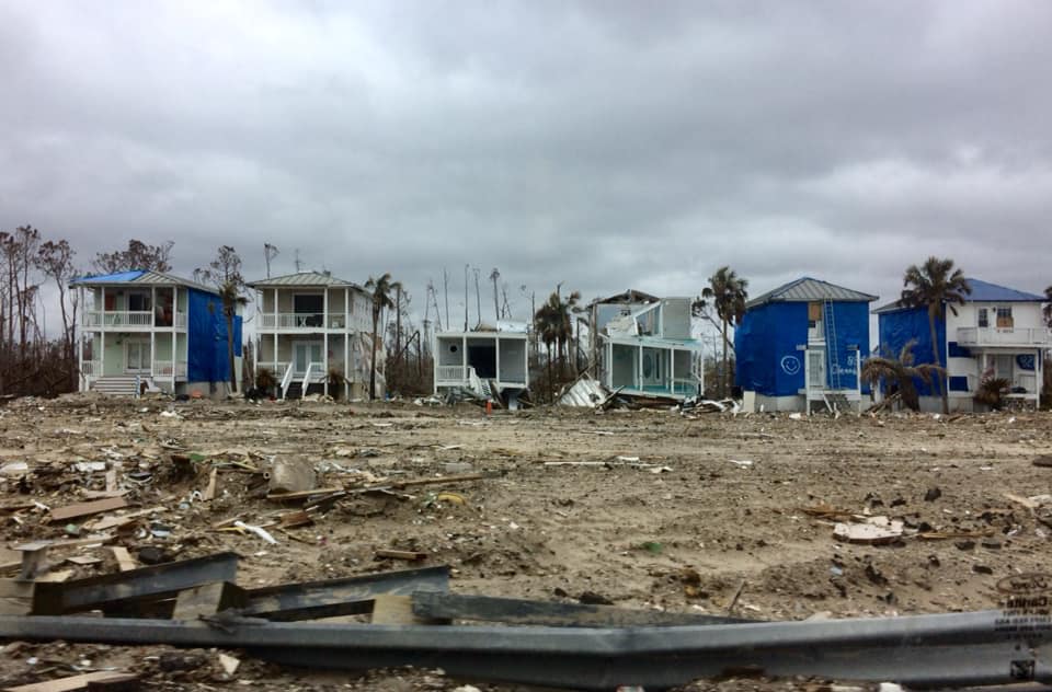
Devastation from Hurricane Michael, October 2018. Photo by David Taylor
Thus began, for me, a new way of thinking about how to engage the public on these issues. I had no experience with film as a vehicle for this process, except as a viewer, but the idea captured my imagination. What can one do with film that would be different from the written word? As the script writer, how would I think about the narrative differently? Moving out of my comfort zone forced me to think even more creatively than usual, but I welcomed the experience because I sensed that it might give us a new way to capture people’s emotions and imagination around an idea whose time was overdue. The United States, and the world, were suffering ever more massive losses from natural disasters, in part as a result of climate change, and needed new ways to approach the problem. Maybe the kinetic visual impact of a film could help affect that, if crafted with the right forward-looking perspectives in mind.
It would not be easy, and I readily understood that. Moreover, the first question was how to pay for the project. Movies are inherently more expensive to produce than books, and involve at least as much work in most ways. But if we could pull this off . . . .
Fortunately, incoming chair-elect Stacy Wright was able to arrange a $5,000 donation from Atkins, a consulting firm, to start the ball rolling in the fall of 2019. I became chair of HMDR on January 1, 2020, but the COVID pandemic intervened within weeks and by March 2020, we had to shut the project down and wait for the best. It was the fall of 2021 before we were again able to move forward. We created a Video Project Advisory Committee to provide guidance on the project. It consists of leading voices in the hazards planning subfield. We also began to assemble teams of regional volunteers who could assist us with logistics and recommend leading planners for interviews and advice.
We chose to name the film Planning to Turn the Tide because of the metaphorical implications of seeking to reverse the growing tide of losses of life and property from natural and other disasters. Well aware of the impacts and trends of climate change, we know that the number and costs of America’s billion-dollar disasters has risen rapidly in recent decades. We also know that planning can make a difference.
Outdoor interview with Julie Dennis, owner of OVID Solutions (also a member of Video Project Advisory Committee) in Blountstown, Florida, July 2022. Holding camera is Kim Taylor Galway; to her left is videographer David Taylor.
In the meantime, we raised additional donations from other consulting firms* and won two small grants from the APA Divisions Council to help us get started. We announced our project in May 2022 at the APA National Planning Conference in San Diego and recorded interviews with leading hazards professionals at the Association of State Floodplain Managers annual conference two weeks later in Orlando. By mid-July, we had recorded 14 more interviews in the Florida Panhandle, mostly in Panama City, following the area’s recovery four years after Hurricane Michael struck as the first Category 5 storm to reach the U.S. mainland since Hurricane Andrew in 1992. In that visit, we had extensive support from both City Hall in Panama City and the Bay County Chamber of Commerce, which provided its board room for a recording studio for an entire day.
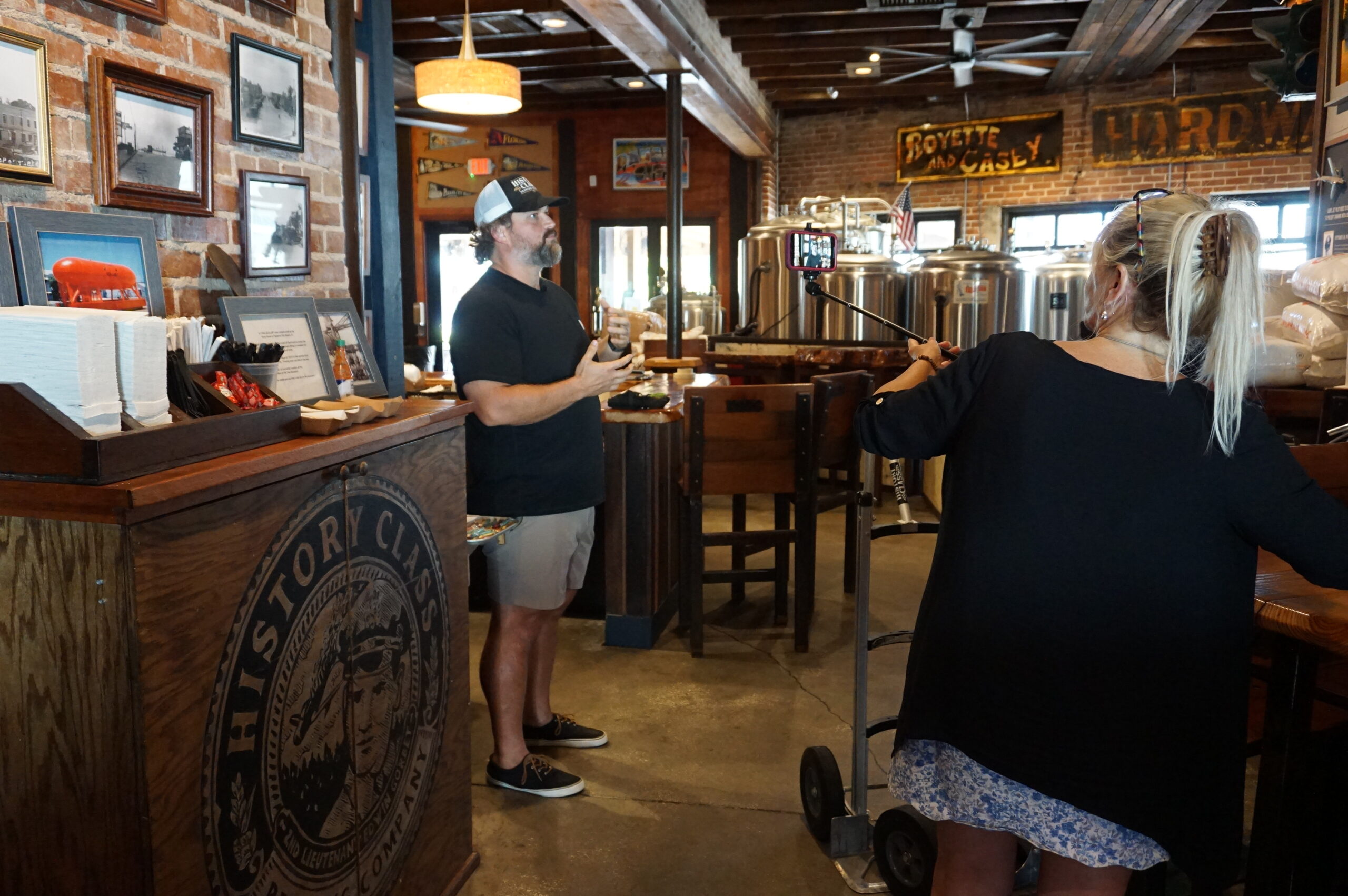
Local entrepreneur Allan Branch explains his restoration efforts at History Class Brewing in downtown Panama City, July 2022
By then, our main problem was that we needed an easy way for people interested in supporting the project to make donations. Fundraising can be hard work, but there is little reason these days to make it harder than it needs to be. APA worked with us over subsequent months to create a dedicated donations page where people could donate online. Because we were the first division in APA’s history to attempt a project like this, we were also the first to need such a mechanism, but by late March of this year, it was ready. The donations page, which you can also reach with the QR code below, channels donations directly to HMDR and tracks the donor information for us, so that we can recognize our supporters appropriately (unless they choose to be anonymous). You can help keep this project moving ahead by donating now, and I sincerely hope you choose to do so. You will be helping us sell the concept of resilient communities to America.
If you need more information on the project itself, visit our project information page. I will be adding new posts regularly as we continue our work, including short blog videos summarizing what we are doing along the way. Please stay in touch.
But the personal impact on me was to remind me to attend to an egregious oversight on my part that began earlier this year with the release by the American Planning Association (APA) of a new Planning Advisory Service Report, Planning for Resilient Infrastructure. I read it, attended to some other business in Texas and Nebraska in late February and early March, and along came the coronavirus, upending most of my existing personal and professional plans and refocusing my attention. But it is time for me to give this report the attention it deserves.
First, there is the question of why it deserves attention. The National Oceanic and Atmospheric Administration (NOAA), which funded the project led by the Association of State Floodplain Managers (ASFPM), which partnered with APA, chose their joint proposal in funding the first round of projects under its Coastal Resilience Grants Program in 2016. As Jeffrey Payne, director of NOAA’s Office for Coastal Management, states in his preface, “Tomorrow isn’t what it used to be. Increasingly, coastal conditions include all the risks of the past, but risks that are amplified by a changing climate, rising seas, and more rapidly fluctuating Great Lakes.”
In the interest of full disclosure, I was involved with ASFPM executive director Chad Berginnis in co-authoring the proposal for this project in the summer of 2015. (After I left APA, ASFPM hired me back as a consultant in later stages of the effort to help refine and focus the PAS Report.) Our intent was both simple and bold. Local governments spend tens of billions of dollars annually on the construction and maintenance of various kinds of infrastructure. Much of that infrastructure, related to essential services including water, wastewater, and transportation, is subject to the impacts of climate change. While, as Payne goes on to state, this is true away from the coast as well, some of those impacts are particularly significant and noticeable in coastal states and communities. In short, a great deal of taxpayer money is at stake regarding the ability of that infrastructure to withstand future climate conditions and natural disasters. Planning for greatly increased resilience is a recipe for improved fiscal stability. This holds true even if, as planned by statute, a greater share of that funding for hazard mitigation projects comes from FEMA through BRIC. Taxpayers are taxpayers, whether the money used is federal, state, or local.
All that said, the serious work of completing the work fell to Joseph DeAngelis at APA, now the manager of the APA Hazards Planning Center, and Haley Briel, a research specialist for the Flood Science Center at ASFPM, along with Michael Lauer, a planning consultant with deep experience in growth management programs in southeastern coastal states.
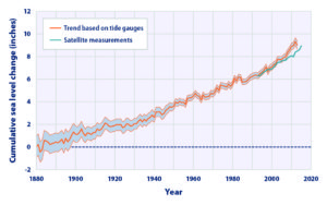
Global average sea level rise from 1880 to the present, based on tide gauges and satellite measurements (US EPA). Reuse courtesy of APA.
Their collaborative report addresses the most significant issues of infrastructure resilience. Particularly in areas subject to coastal storms, these involve not just the impacts of major disasters but the everyday nuisance impacts of flooding because of high tides atop sea level rise that already are yielding closed streets and parks and flooded basements. Urban flooding has become a “thing” where the term never used to be heard. They include a small table with projections by the U.S. Global Change Research Program showing ranges of sea level rise between 0.5 and 1.2 feet by 2050, and 1 to 4 feet by 2100. Of course, these are rough ranges in part because various geological conditions, such as erosion or glacial rebound, cause different results from one region to another, although most of the East Coast faces serious problems over the coming century. A major part of the problem is that sea level rise amplifies the impact of high tides in storms, leading to increased flooding and erosion that is already evident in low-lying cities like Norfolk, Virginia, or Miami. The authors note that, “Over the last half-century alone, with just one to three inches of average sea level rise, daily high-tide flooding has become up to 10 times more frequent” in American coastal communities. Even in Midwestern communities, including those along the Great Lakes, problems result from climate-driven increases in high-precipitation storms that frequently overwhelm stormwater drainage systems built in an earlier era based on other, less challenging, assumptions.
Storm surge heights are cumulatively based on the mean sea level, the height of the tide, and the high volume of water pushed toward the shore by coastal storms (National Hurricane Center). Reuse courtesy of APA.
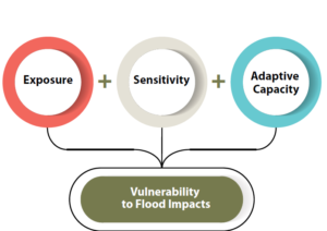
It is natural that a planning document is going to assert a role for planners in addressing these problems. The role the report asserts is entirely logical, starting with “assessing long-term infrastructure needs and understanding future risks to infrastructure assets.” Equally logical, however, is that the report builds upon prior APA literature to outline the need for coordinated action through the plan-making process to integrate climate risk into local plans as a means of “capturing the future conditions to which existing infrastructure and any planned infrastructure projects will be subjected.” Put simply, if the local planning process does not identify those risks and provide clear recommendations for creating resilient infrastructure, it is not likely to materialize in any coherent and consistent fashion. The third chapter outlines a step-by-step approach (see illustrations below) for developing an inventory of local infrastructure, identifying risks, and moving toward an effective plan for adaptation.
The process for conducting an infrastructure vulnerability assessment (Joseph DeAngelis). Reuse courtesy of APA for both diagrams.
A project or asset’s vulnerability to flood impacts is a product of its exposure, sensitivity, and adaptive capacity (Joseph DeAngelis).
Later, the report provides some examples of what such consistent planning for resilient infrastructure may look like. Its case study of San Francisco’s approach to assessing sea-level-rise impacts outlines how the Sea Level Rise Committee of the city’s Capital Planning Committee (CPC), a body responsible for overseeing capital investments for infrastructure, recommended using the upper end of estimates from a National Research Council report for the West Coast. These were fed into a CPC guidance document for assessing vulnerability and supporting adaptation to sea level rise, a primary outcome of climate change. Without engaging the full details here, the bottom line is that the City and County of San Francisco was working from a single play book for climate adaptation of project life cycles for future infrastructure. Capital planning could thus proceed in a more standardized manner based on common assumptions. The report also uses an extensive example from Toledo, Ohio, the site of one of two pilot projects supported by the ASFPM/APA project. Toledo, sitting on the shores of Lake Erie, has suffered from stormwater flooding and is approaching the problem with a mixture of green infrastructure and analysis of social vulnerability in affected neighborhoods. The report elsewhere delves into questions and methods of documenting and addressing environmental justice and social and racial inequities in environmental protection through appropriate local capital planning projects.
Both cases highlight the value for local planners of establishing credible data sources, which often rest within federal agencies such as NOAA and the U.S. Environmental Protection Agency. But, as one chapter illustrates, these can include experienced national nonprofits as well, such as Climate Central. Unquestionably, however, the best single assemblage of data and tools is NOAA’s own Digital Coast website. Planners can access additional high-quality resources on climate through other NOAA programs such as the Regional Climate Centers, located at a series of universities across the nation, and the Regional Integrated Sciences and Assessments, where RISA staff work directly with climate scientists to communicate the science to the public and local officials.
Just as important as understanding where to find the proper data and tools, however, is a knowledge of best practices in local capital improvements planning, the development of effective standards, guidelines, and regulations for creating resilient infrastructure, and, finally, the best means for financing such long-term investments in infrastructure, especially with an eye to climate resilience. Each of these three topics is covered in separate chapters in the second half of the report.
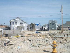
View of part of the Jersey Shore after Hurricane Sandy, February 2013.
Ultimately, the real challenge for local planners is overcoming a natural discomfort with the inherent uncertainties in planning for infrastructure that must withstand the impacts of climate change within a range of assumptions that, in part, depend on federal and even international action to mitigate rising global temperatures as a result of greenhouse gas emissions. Planners, and the communities they serve, must adjust to those uncertainties and the inherent complexities they embody. Planning, however, has always been a speculative enterprise riddled by uncertainties, yet cities have embraced assumptions about population growth, demographic change, and economic scenarios that have often been equally uncertain, for none of us has a crystal ball. What we do know, however, is the direction of existing and accelerating trends, and climate change is no myth. We are ultimately better off, and will better invest public resources, by anticipating climate change with the best projections available, so that our communities are not overwhelmed by future storms, sea level rise, and storm surge. We cannot say we did not see it coming. We can only hope to say we used a wise approach based on the best data available to avoid catastrophe for ourselves and future generations in the communities we serve.
Hillsborough
County is a dense metropolitan area, anchored by the city of Tampa. Tampa and nearby
St. Petersburg, in
Pinellas County, sit on opposite
shores of Tampa Bay, a 400-square-mile
expanse of water connected to the Gulf of Mexico. Across
that gap sits the Sunshine
Skyway Bridge, a magnificent and scenic section of I-275. On a sunny day,
it displays coastal Florida in all its glory.
Eugene
Henry, like anyone else, enjoys those sunny days, but he also worries about
what may happen when the region suffers inclement weather. As Hillsborough
County’s Hazard Mitigation Program Manager, it is his job to think about how
well the area will fare under the impact of natural and other disasters, which
can include hurricanes, floods, tornadoes, sinkholes, and wildfires. At least
the first two are complicated by sea level rise, and one can easily argue that
climate change in a broader sense may well influence the damage from wildfires.
For those uninitiated in the particulars of Florida’s natural environment,
wildfires are a recurring feature. In what is ordinarily such a lush
environment fostered by rain and abundant sunshine, it takes only one drought
year amid high heat to turn dense vegetation into a tinderbox. It has happened
before, repeatedly.
But the biggest concern, by far, is the arrival of the Big
One, the high-intensity hurricane that the county readily admits it has escaped
in recent decades. In its Post-Disaster
Redevelopment Plan (PDRP), the county states forthrightly that this is
merely a matter of good fortune and that planners fully understand that the day
will surely come—and that they had best be ready for it. Disaster resilience in
the face of hurricanes is not a matter to be taken lightly with 158 miles of
shoreline along Tampa Bay, numerous rivers and streams, and numerous
vulnerable, low-lying areas. Absent serious attention to mitigation, damages
from a Category 4 or 5 hurricane, or one like Harvey that stalls and dumps
voluminous rain on an urban area, could become catastrophic.
But Tampa and Hillsborough County have been very fortunate.
The last Category 3 hurricane struck the area in 1921. What may have been a Category
4 struck in 1848, though wind speed measurements were primitive at the time,
and the U.S. had no official records yet. According to the county’s Local
Mitigation Strategy, that storm “reshaped parts of the coast and destroyed
much of what few human works and habitation were then in the Tampa Bay area.”
Tides rose 14 feet. Tampa was still a small city then, and Gene Henry wonders
about the staggering losses that might occur with a comparable event today.
I had long wanted to visit the area to see in person how
these issues are being addressed. I have known Gene for a long time, and I have
read the county’s PDRP, an extensive document laying out the county’s
preparations for recovery from disasters. But I had never been to Tampa. As the
result, however, of a personal invitation from a high school classmate, David Taylor, who now
lives in Sarasota,
my wife and I flew to Tampa February 20 and stayed with Dave and his wife,
Linda, for five days. Sarasota is about one hour’s drive south of Tampa. As
part of the trip, I arranged to meet with Gene the day after we arrived and
tour the county to see the hazard mitigation projects underway there. I also
delivered a one-hour lecture the following afternoon in West Palm Beach,
on behalf of Florida Atlantic University, as part
of a two-hour program that included a panel discussion following my talk on
“Recovery and Resilience: Facing the Disasters of the Future.” Not one to skip
a learning opportunity, Gene drove four hours from Tampa to attend the program.
But back to Hillsborough. My wife and I met Gene at the
county’s Emergency
Operations Center (EOC) around mid-morning, hopped in his county truck, and
took off. Our first stop was the Florida Center
for Design + Research, housed in the School of Architecture + Design at the
University of South Florida (USF),
Gene’s graduate alma mater. The school features an urban planning program where
he wanted us to meet Professor
Brian Cook. Planning students often take studio classes, which involve
design or research work on real-life community problems. Students learn to
define a community design or policy issue, work with clients, and try to
produce solutions that will be of some practical value to the community they
are serving. They typically work in teams. In this case, students were applying
geographic information system (GIS), or mapping, skills to determine areas of
high vulnerability to flooding and sea level rise in less affluent
neighborhoods. Gene’s county office collaborates with USF instructors to
identify areas of practical concern for the students’ work. The photos show
some of the design work the students have done, the best of which is often
displayed in poster sessions at state and national professional planning conferences.
Posters (above and below) from the USF design studio
The most encouraging aspect of that visit was, for me, the mere fact that the students are engaging with such a pressing problem. I have researched the issue of hazards and climate change in the planning curriculum for both undergraduate and graduate degree programs in urban planning, and most such programs are lacking in this respect, a situation that is disserving the planners of tomorrow who must be well trained to come to grips with these challenges in whatever communities they end up serving. But a growing number of students are getting such training—I have myself been teaching such a course at the University of Iowa since 2008—and southern Florida is as good a laboratory as they could wish for. To see collaboration between a county agency and USF graduate students and faculty is a most welcome note.
But Gene had other places to take us in the afternoon,
besides, that is, the Cuban-themed La Teresita restaurant
where we ate lunch—a place I am willing to recommend if you ever visit Tampa.
First up in the afternoon was the University
Mall area north of downtown Tampa and just east of I-275. This involves a
stormwater management and flood-mitigation project in an area subject to a
certain amount of repetitive loss, meaning that the same properties continue to
suffer periodic flood losses. The project removed structures while creating
additional areas for stormwater storage and reshaping a natural area known as
Duck Pond, thus creating a system for stormwater conveyance. This includes a
large stormwater pump that transfers slow-moving stormwater to areas further
downstream and, in due course, to a reservoir owned by the City of Tampa.
Before this project was initiated, storms used to inundate multifamily
apartment buildings, Gene says, as well as a nearby assisted living facility.
How does the county pay for all this? He credits a combination of local funds,
which is certainly not unusual, and federal money in the form of Hazard Mitigation
Grant Program (HMGP) funds. The latter are available as part of an overall
recovery package after a Presidential Disaster
Declaration, but require that purchased properties, once cleared, remain in
perpetual open space. The point is to ensure that a vulnerable area is not
redeveloped, thus perpetuating the problem.
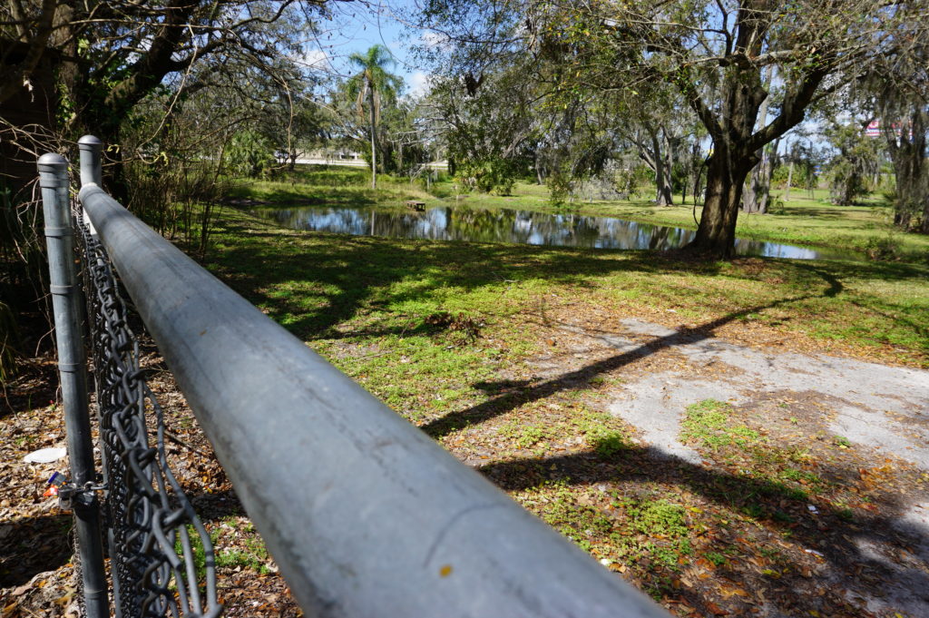
At 132nd Street, also in Tampa, another flood-mitigation
and stormwater management project presents a very different appearance. This
too was subject to repetitive loss and required protection from urban flooding,
which is typically the result of poor stormwater drainage in developed areas. The
problems can include poor water conveyance from one area to the next—the nearby
highway provided an impediment to drainage—and high levels of impervious
surface, meaning coverage with concrete and structures that limit percolation
of water into the soil. In this case, a small subdivision suffered repetitive
flooding even with small storms. Here also, the county acquired homes with HMGP
funds, which are dispensed by the Federal
Emergency Management Agency (FEMA). The streets were removed, and
stormwater ponds were added.
This was a location where the county’s partnership with USF
paid dividends. Researchers analyzed which plants were best at removing
nitrogen and other chemicals common in stormwater runoff in order to clean up
the water before it reaches Tampa Bay. Henry says this project was made
possible through a combination of local and HMGP funds in combination with
federal Community
Development Block Grant entitlement money.
I included the chain link in my photo to show that the solution may not be complete. After all, chain link fences are intended to limit access. What consideration, I asked, had been given to eventually converting this cleared area to some sort of public park and thus facilitating a public benefit? There can be challenges in part because of pollution cleanup and other public safety factors. Gene readily admitted he would love that solution, but it may take time. The adjoining neighborhood must be comfortable with that use, which can involve solving various site-related problems. A nearby church might be a potential ally, serving as a patron and watchdog, but reaching agreement about solutions and responsibilities, including ongoing maintenance and supervision, takes time. And only time will tell whether such a solution materializes with the support of local public officials.
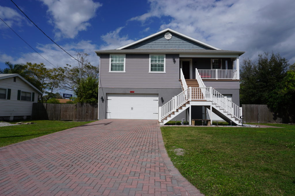
Some projects assist a single homeowner with a stubborn
problem. This is often the case with homes that are elevated, a common site in
parts of the Southeast, where coastal and riverine flooding can wreak havoc
with homes in vulnerable locations that do not necessarily require buyouts and
relocation. That was the case near Rocky Creek,
where a homeowner rebuilt a structure elevated three feet above base flood
elevation (BFE) using a combination of private funds and a Flood
Mitigation Assistance (FMA) grant from FEMA. The result is living space
that is better protected when flood waters surround the lower level.
The same story occurred at a home near the Alafia River, where
another homeowner was elevated three feet above BFE, using the same combination
of funds.
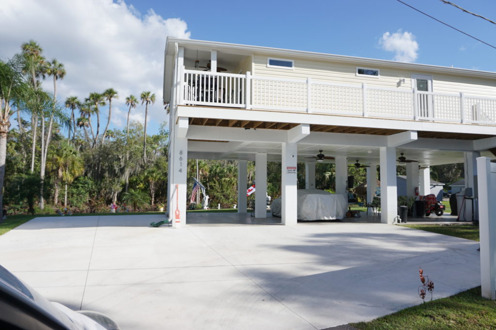
Gene also shared with us an interesting strategy at a
frequently flooded and highly vulnerable modular home park, where an area had
been cleared of its former homes to allow repopulation with recreational
vehicles (RVs). The logic is that, when flood warnings arrive, RV owners will
be able, unlike those with more stationary modular homes, to simply drive off
the site to safer areas until the emergency subsides. The initiative, Gene
says, was taken by the park’s new owner (which owns other parks nationwide), which
identified no more permanent structures in the floodway as part of its
compliance strategy after the most recent flooding event in the area.
This area is slated for RV occupancy only.
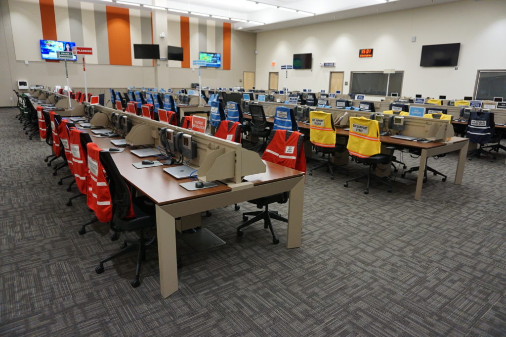
Finally, we returned to learn a little about the EOC. We
visited what is often known in such centers as the “war room,” where designated
officials meet to discuss and establish strategies for dealing with an
emergency of any sort that activates the emergency operations plan. In the
photo, each chair is designated for a specific official, with groups of people
with related tasks seated in color-coded sections of the room. Many such EOCs
are much smaller, but Hillsborough County is very urban and populated, and the
needs are complex and interrelated. It is expected that those involved will
arrive with authority to respond to the disaster, to indicate what they are and
are not capable of doing as part of the overall response to disaster. It is not
a place where one expresses a need to go back to another office and “find out.”
Hillsborough County Emergency Operations Center “war room”
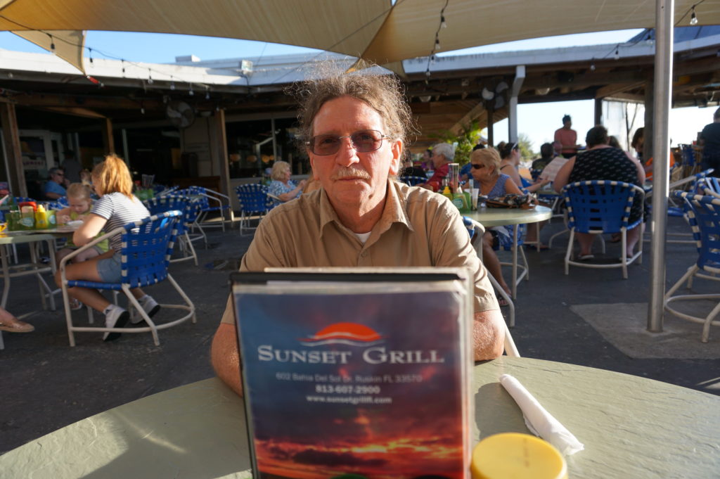
Ready to relax and enjoy a drink and a snack, we followed
Gene down the highway to the Sunset
Grill at Little Harbor, which has a beautiful view of the bay. At dusk,
numerous people followed a daily ritual of photographing the sunset over the
water. Tourist attraction it may be, as well as a local watering hole, but the
surrounding area has a significant mangrove forest and salt-bed areas that were
preserved as open space using Environmental Land Acquisition Funds from what
Gene describes as a “locally instigated preservation program.”
Hillsborough County’s Hazard Mitigation Program Manager, Eugene Henry, at rest at Sunset Grill at the end of our day-long tour.
And so, with the sun declining in the west, we sat at an
outdoor table and hashed over the world’s problems, and sometimes our own. One
point that seems clear to me is that Hillsborough County has a great deal to
offer to other jurisdictions, just as it has undoubtedly learned a great deal
as well—one reason both he and a resident scholar and Japanese graduate student
from the University of Illinois, Kensuke Otsuyama,
planned to drive to West Palm Beach the next day to hear my presentation. Although
there is sometimes a tendency for local governments to become more insular, to
allow fewer opportunities for employees like Gene to share and exchange
information in professional forums and conferences, this, I think, is always a
mistake. The growth in the value of what someone like Gene does lies in this
fruitful sharing of experience and perspectives that such opportunities allow,
and I hope that will continue, for certainly Gene made my day by sharing his
time to allow me to learn and to share with the growing readership that follows
this blog.
Supplemental Comment:
Although the hearing was held today, making live streaming a
moot point, significant written and recorded testimony on hazard mitigation and
climate resilience issues occurred before the U.S. House Appropriations
Subcommittee on Transportation, Housing, and Urban Development. Yesterday, the
following link was made available from several sources including the American Planning
Association (APA) to provide access to this testimony and information:
Representatives from APA, PEW, Houston Public Works,
Rutgers University, and the Town of Arlington, MA are delivering testimony to
the Transportation and Housing and Urban Development (THUD) congressional
subcommittee tomorrow, March 13th at 10:00 a.m. EST. THUD, a part of
the House Committee on Appropriations, writes laws that fund the federal
government’s important responsibilities. The testimony is available for
streaming here: