Digital Coast Act Becomes Real

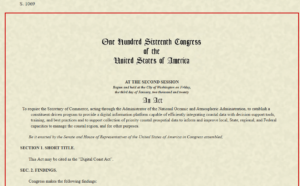
Last Wednesday, December 2, the U.S. Senate passed the Digital Coast Act in a final vote that sent the legislation to President Trump for his signature. If that happens, it may provide a very useful gift to thousands of coastal communities wrestling with a wide variety of coastal zone management challenges.

For more than a decade, the National Oceanic and Atmospheric Administration (NOAA) has sponsored through its Office of Coastal Management a program that has racked up stellar achievements while awaiting congressional blessing of its existence. Digital Coast began as an effort, in collaboration with five nongovernmental partners, to share federal geospatial data and tools with communities in ways that did not require a Ph.D. scientist to interpret them for local government uses.

Geospatial technology, not a familiar term for the average American, refers to “modern tools contributing to the geographic mapping and analysis of the Earth and human societies,” according to the American Association for the Advancement of Science (AAAS). In a coastal context, that includes tools for measuring, projecting, and visualizing sea level rise, as well as monitoring land uses and land cover in coastal areas, and mapping offshore areas as well. The mission of Digital Coast was to make these tools ever more useful for local government planners, resource managers, economic development agencies, and others with some sort of meaningful engagement with coastal issues and data.

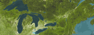
Why is that important? For starters, because more than half of the U.S. population now lives in counties along either an oceanic or Great Lakes coast, and that percentage is growing. It matters greatly where these counties, and their cities, allow new development, how they court economic growth, and how they manage coastal resources, including marine life, tidal wetlands, and offshore resources, as well as ports and near-shore transportation. These coastal areas are huge drivers of the overall U.S. economy, and better data, and better access to data, will deeply affect the American future.

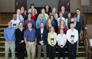
Digital Coast partners and staff at a 2015 meeting. I am at front row, right. 

Improving that access and making tools easier to use, and data more understandable, has been the mission of the Digital Coast Partnership that was assembled from 2008 on, initially with five organizations: Association of State Floodplain Managers (ASFPM); The Nature Conservancy (TNC); National Association of Counties (NACo); National States Geographic Information Council (NSGIC); and Coastal States Organization (CSO). In the summer of 2010, the American Planning Association joined the partnership, an initiative I led as manager of APA’s Hazards Planning Center. Allison Hardin, a planner for the city of Myrtle Beach, South Carolina, and immediate past chair of APA’s Hazard Mitigation and Disaster Recovery Planning Division (which I now chair), reports that in 2009, she vigorously advocated for the addition of APA. At the time, Allison, a certified floodplain manager, was helping to represent ASFPM in the partnership. Today, there are eight nongovernmental partners, all of which serve as links to professional user communities to ensure widespread uptake of the data, tools, and resources available from Digital Coast. The two additions have been the Urban Land Institute and National Estuarine Research Reserve Association.

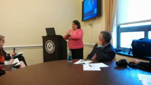
Allison Hardin speaking at Capitol briefing. 

So, what difference does statutory authorization of Digital Coast make? According to John Palatiello, president of John M. Palatiello & Associates, Inc., a government relations and association management firm representing the surveying, mapping, GIS, and geospatial community, which helped lead the effort to get the act passed: “The Digital Coast Act will enable NOAA to partner with other government entities and the private sector to help protect and promote America’s coasts and shorelines. This legislation creates a program to utilize the extensive capabilities, competence, and qualifications of private sector geospatial professionals to provide the surveying, charting, remote sensing, and geospatial data of America’s coasts, harbors, ports, shorelines and ocean resources for economic growth, recreational activities, conservation, and resilience of our fragile coastal environment.” Put more simply, the new law stabilizes the authorization and budgetary support for Digital Coast within NOAA. There were times in the past when this was less than a sure thing. Now, its codification makes its program status official.

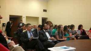
Digital Coast Act briefing, with NOAA Digital Coast staff Miki Schmidt (left) and Josh Murphy (right), standing near door.

But Digital Coast, I can attest from personal experience, has a remarkably astute and dedicated professional staff in love with public service. The Act itself begins with this finding: “The Digital Coast is a model approach for effective Federal partnership with State and local government, nongovernmental organizations, and the private sector.” It goes on to note, a few paragraphs later, some of the needs that Digital Coast can help address, including flood and coastal storm surge prediction, hazard risk and vulnerability assessment, and community resilience, as well as ecosystem health. I applauded the program more than six years ago on this blog.

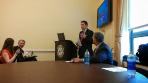
Briefing at the Capitol: APA Policy Director Jason Jordan at the mike; ASFPM Executive Director Chad Berginnis to his right.

It is important to note that this legislation is not the product of some recent brainstorm, but of a slow, steady process of building support, starting with a handful of legislators from both parties who saw its value. Perhaps most notable was Sen. Tammy Baldwin (D-WI), accompanied in the House by Rep. Dutch Ruppersberger (D-MD), who noted in a press release that he had been advocating such action for nearly a decade. But Republican support came from Rep. Don Young (R-AK) and Sens. Lisa Murkowski and Dan Sullivan, both of Alaska, the state with by far the longest coastline. All of them, along with the Digital Coast partners, plus the indefatigable John Byrd of MAPPS, pushed relentlessly, year after year, to find the support necessary to move the bill across the legislative goal line. They have at last succeeded.

Jim Schwab

The Need for Resilient Infrastructure

This summer, the Federal Emergency Management Agency (FEMA) is at last rolling out its Building Resilient Infrastructure and Communities (BRIC) program, and its first Notice of Funding Opportunity will likely be issued in September. In July, FEMA is airing a series of five weekly webinars to introduce BRIC to communities and state officials around the nation. BRIC is the practical result of provisions in the Disaster Recovery Reform Act, passed by Congress in 2018, to create a secure funding stream for what was formerly the Pre-Disaster Mitigation program. I plan to discuss all that in coming weeks on this blog.

But the personal impact on me was to remind me to attend to an egregious oversight on my part that began earlier this year with the release by the American Planning Association (APA) of a new Planning Advisory Service Report, Planning for Resilient Infrastructure. I read it, attended to some other business in Texas and Nebraska in late February and early March, and along came the coronavirus, upending most of my existing personal and professional plans and refocusing my attention. But it is time for me to give this report the attention it deserves.

First, there is the question of why it deserves attention. The National Oceanic and Atmospheric Administration (NOAA), which funded the project led by the Association of State Floodplain Managers (ASFPM), which partnered with APA, chose their joint proposal in funding the first round of projects under its Coastal Resilience Grants Program in 2016. As Jeffrey Payne, director of NOAA’s Office for Coastal Management, states in his preface, “Tomorrow isn’t what it used to be. Increasingly, coastal conditions include all the risks of the past, but risks that are amplified by a changing climate, rising seas, and more rapidly fluctuating Great Lakes.”

In the interest of full disclosure, I was involved with ASFPM executive director Chad Berginnis in co-authoring the proposal for this project in the summer of 2015. (After I left APA, ASFPM hired me back as a consultant in later stages of the effort to help refine and focus the PAS Report.) Our intent was both simple and bold. Local governments spend tens of billions of dollars annually on the construction and maintenance of various kinds of infrastructure. Much of that infrastructure, related to essential services including water, wastewater, and transportation, is subject to the impacts of climate change. While, as Payne goes on to state, this is true away from the coast as well, some of those impacts are particularly significant and noticeable in coastal states and communities. In short, a great deal of taxpayer money is at stake regarding the ability of that infrastructure to withstand future climate conditions and natural disasters. Planning for greatly increased resilience is a recipe for improved fiscal stability. This holds true even if, as planned by statute, a greater share of that funding for hazard mitigation projects comes from FEMA through BRIC. Taxpayers are taxpayers, whether the money used is federal, state, or local.

All that said, the serious work of completing the work fell to Joseph DeAngelis at APA, now the manager of the APA Hazards Planning Center, and Haley Briel, a research specialist for the Flood Science Center at ASFPM, along with Michael Lauer, a planning consultant with deep experience in growth management programs in southeastern coastal states.

Global average sea level rise from 1880 to the present, based on tide gauges and satellite measurements (US EPA). Reuse courtesy of APA.

Their collaborative report addresses the most significant issues of infrastructure resilience. Particularly in areas subject to coastal storms, these involve not just the impacts of major disasters but the everyday nuisance impacts of flooding because of high tides atop sea level rise that already are yielding closed streets and parks and flooded basements. Urban flooding has become a “thing” where the term never used to be heard. They include a small table with projections by the U.S. Global Change Research Program showing ranges of sea level rise between 0.5 and 1.2 feet by 2050, and 1 to 4 feet by 2100. Of course, these are rough ranges in part because various geological conditions, such as erosion or glacial rebound, cause different results from one region to another, although most of the East Coast faces serious problems over the coming century. A major part of the problem is that sea level rise amplifies the impact of high tides in storms, leading to increased flooding and erosion that is already evident in low-lying cities like Norfolk, Virginia, or Miami. The authors note that, “Over the last half-century alone, with just one to three inches of average sea level rise, daily high-tide flooding has become up to 10 times more frequent” in American coastal communities. Even in Midwestern communities, including those along the Great Lakes, problems result from climate-driven increases in high-precipitation storms that frequently overwhelm stormwater drainage systems built in an earlier era based on other, less challenging, assumptions.

Storm surge heights are cumulatively based on the mean sea level, the height of the tide, and the high volume of water pushed toward the shore by coastal storms (National Hurricane Center). Reuse courtesy of APA.

It is natural that a planning document is going to assert a role for planners in addressing these problems. The role the report asserts is entirely logical, starting with “assessing long-term infrastructure needs and understanding future risks to infrastructure assets.” Equally logical, however, is that the report builds upon prior APA literature to outline the need for coordinated action through the plan-making process to integrate climate risk into local plans as a means of “capturing the future conditions to which existing infrastructure and any planned infrastructure projects will be subjected.” Put simply, if the local planning process does not identify those risks and provide clear recommendations for creating resilient infrastructure, it is not likely to materialize in any coherent and consistent fashion. The third chapter outlines a step-by-step approach (see illustrations below) for developing an inventory of local infrastructure, identifying risks, and moving toward an effective plan for adaptation.

The process for conducting an infrastructure vulnerability assessment (Joseph DeAngelis). Reuse courtesy of APA for both diagrams.


A project or asset’s vulnerability to flood impacts is a product of its exposure, sensitivity, and adaptive capacity (Joseph DeAngelis).

Later, the report provides some examples of what such consistent planning for resilient infrastructure may look like. Its case study of San Francisco’s approach to assessing sea-level-rise impacts outlines how the Sea Level Rise Committee of the city’s Capital Planning Committee (CPC), a body responsible for overseeing capital investments for infrastructure, recommended using the upper end of estimates from a National Research Council report for the West Coast. These were fed into a CPC guidance document for assessing vulnerability and supporting adaptation to sea level rise, a primary outcome of climate change. Without engaging the full details here, the bottom line is that the City and County of San Francisco was working from a single play book for climate adaptation of project life cycles for future infrastructure. Capital planning could thus proceed in a more standardized manner based on common assumptions. The report also uses an extensive example from Toledo, Ohio, the site of one of two pilot projects supported by the ASFPM/APA project. Toledo, sitting on the shores of Lake Erie, has suffered from stormwater flooding and is approaching the problem with a mixture of green infrastructure and analysis of social vulnerability in affected neighborhoods. The report elsewhere delves into questions and methods of documenting and addressing environmental justice and social and racial inequities in environmental protection through appropriate local capital planning projects.

Both cases highlight the value for local planners of establishing credible data sources, which often rest within federal agencies such as NOAA and the U.S. Environmental Protection Agency. But, as one chapter illustrates, these can include experienced national nonprofits as well, such as Climate Central. Unquestionably, however, the best single assemblage of data and tools is NOAA’s own Digital Coast website. Planners can access additional high-quality resources on climate through other NOAA programs such as the Regional Climate Centers, located at a series of universities across the nation, and the Regional Integrated Sciences and Assessments, where RISA staff work directly with climate scientists to communicate the science to the public and local officials.

Just as important as understanding where to find the proper data and tools, however, is a knowledge of best practices in local capital improvements planning, the development of effective standards, guidelines, and regulations for creating resilient infrastructure, and, finally, the best means for financing such long-term investments in infrastructure, especially with an eye to climate resilience. Each of these three topics is covered in separate chapters in the second half of the report.

View of part of the Jersey Shore after Hurricane Sandy, February 2013.

Ultimately, the real challenge for local planners is overcoming a natural discomfort with the inherent uncertainties in planning for infrastructure that must withstand the impacts of climate change within a range of assumptions that, in part, depend on federal and even international action to mitigate rising global temperatures as a result of greenhouse gas emissions. Planners, and the communities they serve, must adjust to those uncertainties and the inherent complexities they embody. Planning, however, has always been a speculative enterprise riddled by uncertainties, yet cities have embraced assumptions about population growth, demographic change, and economic scenarios that have often been equally uncertain, for none of us has a crystal ball. What we do know, however, is the direction of existing and accelerating trends, and climate change is no myth. We are ultimately better off, and will better invest public resources, by anticipating climate change with the best projections available, so that our communities are not overwhelmed by future storms, sea level rise, and storm surge. We cannot say we did not see it coming. We can only hope to say we used a wise approach based on the best data available to avoid catastrophe for ourselves and future generations in the communities we serve.

Jim Schwab


Gratitude on Parade #3

GRATITUDE ON PARADE
#gratitudeonparade
[Partners of] the National Oceanic and Atmospheric Administration‘s Digital Coast program are hosting a meeting in Washington, D.C., today of the Digital Coast Partnership, an assortment of eight national nonprofit organizations willing to support geotechnical services to coastal communities across the U.S. The Digital Coast staff have been leading this effort for more than a decade, and the result is better decision making on coastal land use and resource management among the communities using Digital Coast tools and resources.

I attended these meetings and participated in Digital Coast projects until I left the American Planning Association, one of those partners, in 2017. But as of 2010, when APA joined the partnership, I found the entire enterprise a magnificent example of positive federal engagement with local governments and user communities in need of better data and easier ways to access data. And I made some fast friends because of the quality of the staff.

Leading that effort was one remarkable human being, Miki Schmidt, who has been with NOAA that entire time. Miki has a positive, can-do attitude, and helped me learn a great deal about what positive federal outreach could look like. We had numerous valuable conversations about how to move forward, and Miki repeatedly expressed his gratitude to APA for becoming part of the entire effort. But he deserves recognition for doing a top-notch job year after year, and empowering a staff that couldn’t be better. Near the end of my era, also, as depicted in the photo below, he organized a retirement “roast” at a restaurant during a NOAA Coastal GeoTools Conference. I could not have asked for a nicer tribute.

James Schwab CORRECTION: I did not realize that NOAA was caught up in the federal government shutdown and NOAA staff are not present at the meeting mentioned in the first sentence. it is a tribute to the success of the partnership, however, that the National Association of Counties, one of the partners, is hosting and the partners are proceeding with the meeting on their own. I just did not realize that was the case. Let us all hope that, one day, these shutdowns will be a thing of the past that is no longer an acceptable practice.

Miki, at right, prior to dinner that included a retirement roast.

Posted on Facebook 1/15/2019

GRATITUDE ON PARADE
#gratitudeonparade
I am not done singing the praises of Digital Coast nor of expressing my gratitude to outstanding staff of that program. If I had an opportunity to nominate someone for Liaison of the Year, someone with an outstanding sense of customer relations, it would surely be Susan Fox, who actually works with the Baldwin Group on behalf of NOAA, and has served for several years as a Digital Coast liaison with the American Planning Association. I had the honor to work with her while managing APA’s Hazards Planning Center into 2017. She is enthusiastic, positive, very well-organized, and incredibly supportive. Just like Miki Schmidt, about whom I wrote yesterday, she is a pillar of the Digital Coast program. Thank you, Susan, for all you do.

Susan in Manhattan for dinner during APA National Planning Conference, 2017.

Posted on Facebook 1/16/2019

GRATITUDE ON PARADE

#gratitudeonparade

Continuing with my tributes to Digital Coast staff, I must now know mention the invaluable Josh Murphy, who works from NOAA’s headquarters in Silver Spring, Maryland. Josh was the creative soul who helped negotiate a HUD-funded, NOAA-sponsored project led by AECOM but involving Digital Coast partners (APA, NACo, ASFPM) to work with two pilot communities (Brevard County, FL, and San Luis Obispo County, CA) to help operationalize concepts for integrating resilience and hazard mitigation priorities into the local planning process. This is rather advanced stuff and requires some real skill to manage, but we all did it together, advancing the frontiers of planning. And we had Josh to thank for making it all possible. He is one of NOAA’s truly valuable assets.

Courtesy of Shannon Burke

Posted on Facebook 1/17/2019

GRATITUDE ON PARADE
#gratitudeonparade
As I complete this round of gratitude to Digital Coast staff, I wish to make clear that there are many others at NOAA for whom we should all be grateful beyond those I have highlighted. But I do want to close by mentioning the remarkable Lori Cary-Kothera, whose consistent demonstrations of enthusiasm, high intelligence, and dedication have also helped the partners to succeed in their efforts both to support the Digital Coast program and to advance their own respective projects and services to coastal communities. Lori is one of those rare people you can count on for positive advice and support. She is also a welcome beacon of warmth and humanity.

Courtesy of Shannon Burke

Posted on Facebook 1/18/2019

Jim Schwab

Step Forward on Water Hazards Resilience

Satellite photo of Great Lakes and St. Lawrence Seaway. Image from NOAA Great Lakes Environmental Research Laboratory (CC BY-SA 2.0).

It is time to make America resilient. The trends have been moving us in the wrong direction for a long time, but we know how to reverse them.

Planners — and elected officials — have to embrace the science that will inform us best on how to achieve that goal, and we have to develop the political will to decide that public safety in the face of natural hazards is central both to fiscal prudence and the kind of nation we want to be. America will not become great by being short-sighted.

Damage from natural disasters is taking an increasing toll on our society and our economy. The National Oceanic and Atmospheric Administration (NOAA), currently the target for serious budget cuts by the Trump administration, operates the National Centers for Environmental Information (NCEI), a vital national resource center for data. It has long tracked the number and costs of the nation’s weather and climate-related disasters, and the conclusion is unavoidable: The number of billion-dollar disasters is growing and getting worse.

APA’s Hazards Planning Center has long studied and highlighted best planning practices for addressing the vulnerabilities that lead to such disaster losses. However, the uptake into community planning systems varies, and it is often a long process challenged by resource shortages.

In recognition of Water Week, I offer the following recommendations to Congress for ways in which federal partners and planners can work together to create stronger, more resilient communities:

Maintain funding levels

Maintaining the necessary funding support for agencies like NOAA is critical for providing us with the baseline information the nation needs to track data. It’s only through the ongoing coordination, maintence, and strengthening of national data resources that federal partners will truly be able to support local planning efforts. More data — not less — is the key to creating hazards policy that prepares communities for the future.

Translate science into good public policy

It is important to find new and better ways to translate science into good public policy. This is one of the objectives for NOAA’s Regional Coastal Resilience program — just one of the many important grants in danger of being defunded in FY 2018.

Support America’s coastal communities by ensuring that they benefit from projects directing the nation’s scientific and technical ingenuity to solve problems related to coastal hazards. The price tag is a tiny fraction of what the nation spent on recovery from Hurricane Sandy. The program is clearly a wise investment in our coastal future.

Reauthorize the National Flood Insurance Program

The National Flood Insurance Program expires this year. Reauthorization must include continued support for the flood mapping program so communities have essential baseline information on the parameters of their flooding challenges.

Municipalities and counties need accurate and current flood mapping and data in order to make more informed judgments on both how and where to build. Only then will the nation begin to dial back the volume of annual flood damages.

Pass the Digital Coast Act

Passing the Digital Coast Act means authorizing and enabling NOAA to provide the suite of tools, data, and resources under the Digital Coast program that have proved useful to local planners, coastal resource managers, public works departments, and water agencies in better managing coastal zones and the natural systems that keep them healthy.

Through the Digital Coast Partnership, APA has been a strong advocate for formalizing NOAA’s Digital Coast project through legislation and providing adequate federal appropriations for robust funding.

This legislation already has bipartisan support because the program shows government at its best in providing cost-effective support to scientifically informed public policy and decision making.

As APA Past President Carol Rhea, FAICP, has noted, “This legislation will directly improve local disaster response and hazard mitigation planning. This bill will help local communities minimize potential loss of life and damage to infrastructure, private property, and conservation areas. The Digital Coast Act is an important step for effective coastal management.”

Continue funding for the Great Lakes Restoration Initiative

The U.S. Environmental Protection Agency was created partly in response to the sorry condition of the Great Lakes and major tributaries like the Cuyahoga and Maumee Rivers. We have come a long way since then. The lakes and rivers are healthier, and the communities around them are, too. Yet the administration’s budget would zero out such programs despite their megaregional and even international impacts.

Recognize the progress we have made and renew America’s commitment to further improve these major bodies of water. Support coastal resilience along the Great Lakes.

These are not dramatic requests. Mostly, they recognize the slow but steady progress — and the persistent creativity — that has resulted from past commitments. They are, however, critical to successful water policy and to our national future as a resilient nation.

Jim Schwab

This post is reprinted from the APA Blog with permission from the American Planning Association, for which it was produced.

All’s Well at Burwell’s

Chad Berginnis shares a story during the roast. To his right is Nicole LeBouef, new Deputy Assistant Administrator for NOAA for the National Ocean Service. Photo by Susan Fox.

Chad Berginnis shares a story during the roast. To his right is Nicole LeBouef, new Deputy Assistant Administrator for NOAA for the National Ocean Service. Photo by Susan Fox.

Warmth is a concept with many dimensions. In the realm of physics, it is a relative measure of temperature. In reference to weather, perhaps the most common subject of human conversation, it is a measure of the kinetic energy of the atmosphere around us, which is constantly changing. Mark Twain has been erroneously quoted as saying, “Everybody talks about the weather, but nobody does anything about it.” His friend Charles Dudley Warner sort of said it, but no mind. On Tuesday, February 7, in Charleston, South Carolina, no one around me had any complaints. We were perfectly happy with the kinetic energy of the atmosphere of the day, which brought the city to a very comfortable 75° F. No rain, just a mild breeze. Let it be. (You can accurately take that quote from the Beatles.) Two days later, I would have to return to Chicago, where it was 18° F. when I stepped off the airplane.

Like many other English words, warmth takes on many metaphorical and emotional connotations derived from its physical qualities. “If you can’t stand the heat, get out of the kitchen,” President Harry Truman used to say, and he was not referring to room temperature in the White House. Conversely, there is the warmth of positive human relationships, just as there is a chill in the air when they are not going well.

That evening, at a downtown Charleston restaurant, Burwell’s, I experienced that warmth at a group dinner organized by some National Oceanic and Atmospheric Administration (NOAA) staff for those members of the NOAA Digital Coast Partnership who were attending the Coastal GeoTools Conference. The partnership consists of both NOAA, through its National Ocean Service, and eight national nonprofit organizations, including the American Planning Association, which I represented along with a colleague, Joseph DeAngelis, a research associate for the Hazards Planning Center. The conference was hosted for NOAA by the Association of State Floodplain Managers (ASFPM).

Susan Fox, NOAA point of contact for APA in the Digital Coast Partnership, presents a gift before the roast. Photo by Miki Schmidt.

Susan Fox, NOAA point of contact for APA in the Digital Coast Partnership, presents a gift before the roast. Photo by Miki Schmidt.

But enough of the organizational details. Shortly after all our carloads arrived at Burwell’s, and our party of 24 was led upstairs by the wait staff, it became apparent that something special was afoot. Miki Schmidt, Division Chief for Coastal Geospatial Services at NOAA, attempted to get people’s attention by clinking empty glasses. It wasn’t working, so I decided to use my booming voice to say, “Miki wants your attention.” That worked. Then he announced, to my surprise, that they wanted to honor my upcoming retirement with a few gifts, among which were a framed certificate of appreciation from the U.S. Department of Commerce for my service in supporting Digital Coast and a framed photograph of those who had attended the last full meeting of the partnership in Rhode Island in September 2016, signed by many of the attendees. The warmth of the professional and personal relationships built with colleagues since APA joined the partnership in 2010 became readily apparent to me in this unexpected moment.

Allison Hardin poses with the wolf; David Hart observes (September 2011). Photo by Melissa Ladd.

Allison Hardin poses with the wolf; David Hart observes (September 2011). Photo by Melissa Ladd.

Then we sat down, and the “roast” began. More than once, as Miki seemed ready to turn the floor over to me for the final word, someone new would pop up to offer stories both fun and serious. Yes, it was true that I had once, wearing a moveable wolf mask, climbed through the open window of a park shelter in Madison, Wisconsin, during an evening reception for a partnership meeting hosted by ASFPM, asking the whereabouts of “them three little pigs.” Undaunted by the momentary confusion my entrance engendered, Allison Hardin, a planner from Myrtle Beach, South Carolina, insisted on posing for a photograph with the wolf, who politely obliged. I was known (though not alone) in trying to provide such moments to enliven the more relaxing moments of partnership gatherings. When my “final word” finally came, I shared not only some enhancements of the recollected moments, but my own plans beyond APA, which I discussed in a recent blog post, “The Fine Art of Stepping Down.”

Still, the Digital Coast Partnership was also built through a great deal of hard work, which was also celebrated. The representatives of the groups involved worked hard over the past decade to build the partnership, which is now celebrating its tenth year. Meetings sometimes involved long discussions of how we could better collaborate, and we now often partner on important proposals and projects in which our complementary strengths facilitate important progress in achieving Digital Coast’s mission. NOAA established Digital Coast to advance the use of geospatial technology by coastal communities to improve and enhance coastal planning and resource management. Much of this consists of a substantial and growing of free, online tools and resources for mapping and visualization purposes. The partnership consists of the user communities that can help vet Digital Coast products and assist in their dissemination. But the operative Digital Coast slogan has been “More than just data.” It is the human dimension that matters, and the science and technology have been means to an end, which is enabling the achievement of noble coastal community goals such as environmental protection, hazard mitigation, economic sustainability, and climate resilience.

And so—I suppose it was appropriate that the organizers of the dinner chose to bring us to Burwell’s Stonefire Grill, which generates its own warmth through its comfort menu of steaks and seafood. Though it certainly can be pricey like any steakhouse (most steak entrees are between $30 and $40), the food is outstanding. Personally, I indulged in the lobster bisque for starters. It offered some of the deepest, most flavorful spoonfuls of joy of any bisque I have had in a long time. Alan, our waiter, was not lying at all when he told me it was great. On the subject of warmth, let me add that the wait staff of Alan, Mat, and Will were very patient and careful in tending to this large crowd, as was bartender Jo Jo Chandler. I did not meet the owner, John Thomas, but he is to be commended for both the staff and the cuisine. The Wagyu flat iron steak that I ordered was tender and delicious. I also indulged in a side order of Brussels sprouts, which I love but which require some attentive preparation to succeed. These were great in part because they were prepared in combination with caramelized onions. Others around me

Miki to the right of me in the upstairs dining room at Burwell's.

Miki to the right of me in the upstairs dining room at Burwell’s. Photo by Susan Fox.

enjoyed the seafood offerings, including oysters and scallops, and I heard no complaints and considerable praise. I can assure readers that, if you visit Charleston, Burwell’s is worth a visit for one of your evening outings. It also features a warm and casual atmosphere and a good downstairs bar, from which that amber beer in my hand originated, courtesy of Chad Berginnis, the executive director of ASFPM. I wasn’t sure, when we first arrived, why he offered to buy. Now I suspect he was in on the “roast” plan all along. Thanks, I say, to all of my friends at Digital Coast. My actual retirement from APA may have been almost four months away, but they knew this might be the last chance to do it before that day came. I hope they do the same for others when the time comes.

Jim Schwab


Digital Coast: A Model for Progress

In an era of congressional gridlock, with so little productive activity coming out of Washington that many people have begun to wonder if federal government is good for anything, the best models often work quietly in the shadows—and they may not even work primarily out of Washington. They work around the country, in the hinterlands, and along the coasts. They may even have odd names like Digital Coast, suggesting the marriage of digital technology with environmental and coastal planning needs. This is the story, in my own idiosyncratic fashion, of one such model.

Just last week, I spent three days in Milwaukee at a meeting of the Digital Coast Partnership, which is affiliated with the National Oceanic and Atmospheric Administration (NOAA), an arm of the U.S. Department of Commerce. Digital Coast is a program of NOAA’s Coastal Services Center (CSC), based in Charleston, South Carolina. CSC is in the process of merging with the Office of Ocean and Coastal Resource Management (OCRM), in order to form a single coastal operation within NOAA. OCRM has been responsible for administering the Coastal Zone Management Act (CZMA), a piece of legislation passed in 1972 that supports a cooperative approach to better coastal resource management between the states and the federal government. But all this may be more bureaucracy than most people want to know, so let’s cut to the chase.

Overburdened local governments and regional planning agencies in coastal areas often do not have all the resources they may need to do a thorough job of planning intelligently for the future of the nation’s coastline. Under the CZMA, that coastline includes all areas along the Atlantic, Pacific, and Arctic Oceans, the Gulf of Mexico, and the Great Lakes, including estuaries and bays like the Chesapeake Bay. In addition to tens of thousands of miles of coast, this area also is home to 39 percent of the U.S. population and many of our largest cities, including Boston, New York, Miami, Los Angeles, San Francisco, Seattle, Chicago, and Honolulu. In all, some 30 states and five territories are included in the Coastal Zone Management Program.

Managing coastal resources is a delicate balancing act that includes planning for many environmentally sensitive areas, economic powerhouses and attractive tourist destinations, and major ports that drive trillions of dollars in economic activity. It requires advanced planning tools, knowledge of both economics and environmental science, and an understanding of the demographics of these areas, which can be very diverse. Many of our coastal cities like New York have been historic points of entry for many of the immigrants who have subsequently built so much of the modern United States.

Providing a modest suite of online tools and resources to make that job just a little easier at the local level is the job of Digital Coast. But now I am going to dive into the truly interesting part of this whole story—the emergence of the partnership.

Early in 2010, I was approached by representatives of NOAA on behalf of the Digital Coast program to gauge the interest of the American Planning Association in joining what was then a group of five national organizations that comprised the Digital Coast Partnership. These were the original team that had been assembled to help NOAA assess the usefulness of the resources it was creating and to reach deeply into the user communities for those resources to spread the word that this online resource existed. Those five organizations were The Nature Conservancy, National States Geographic Information Council, Coastal States Organization, Association of State Floodplain Managers, and National Association of Counties. Within the first year, they determined that something was missing—contact with urban planners. So they decided to invite us to join them. By July 2010, we signed an agreement to do exactly that, and we have never looked back. At the same time, as Nicholas J. (“Miki”) Schmidt, CSC’s Division Chief for Coastal Geospatial Services, likes to say, they could not be happier that APA joined.

What is the point of this partnership? It is long past the point in American history where a federal agency can afford to develop a new resource for local government without having some means to determine whether what they think will be useful actually is what is most useful to practitioners. Collaboration is more the order of the day. Find the people who will have to make best use of the tools, resources, and data you want to create, and ask whether what you have in mind is as useful as it could be, or even useful at all. If those user groups can vet your product and tell you seriously that, with perhaps this change or that tweak, what you are considering developing would be beneficial to local officials, planners, and resource managers, then go for it. If not, rethink it. In the end, what emerges is a highly productive symbiotic relationship in which those who must make better coastal planning and resource management happen at a local and regional level have a voice in the kinds of tools, data, and resources that may make their jobs easier.

As logical as all that sounds, the case for this model becomes even more compelling in the context of climate change. Our evolving climate, driven by the relentless addition of greenhouse gases from modern transportation, industry, and agriculture, among other, lesser sources, has greatly complicated long-term prediction models, particularly as they affect the modeling of future natural hazards such as flooding, drought, heat waves, and coastal storms. Unfortunately, at the same time, NOAA, as the governmental entity providing or funding much of the science of climate change, has had a target on its back in some of the oversight committees in Congress, especially those now chaired by skeptics of climate change. Some of these members of Congress seem virtually impervious to the mountains of evidence produced both domestically and internationally, to the nearly unanimous consensus behind the theory of climate change among climate scientists, and to the many reports that have supported climate concerns. We live in a strange universe in which science itself has become suspect among some in the halls of Congress, even as the need for scientific insights into complex planetary processes becomes more profound, and the long-term economic consequences of any missteps become ever more frightening. Several recent reports (e.g., Risky Business) and books suggest that we are playing Russian roulette with the world’s economic future.

But again, I digress. I am trying to focus on the value of Digital Coast and the partnership that supports it.

So back to Milwaukee. Our three days there were the latest iteration of a series of twice-yearly meetings of the partners and their NOAA compatriots in an ongoing quest to advance the program and enhance its value, something the partnership has been doing for more than five years now. In the past year, we added two new organizations that have embraced the partnership with enthusiasm: Urban Land Institute, and the National Estuarine Research Reserve Association (NERRA). The latter may sound like a mouthful; it is a relatively small organization, but it is important. Its members constitute the staff of a nationwide network of national estuarine research reserves, where services are provided to monitor and learn the value of coastal and tidal estuaries, to provide educational and environmental services, and to help us all learn what a biologically rich system these estuaries provide if properly cared for. The coast is an intricate fabric of ecosystems. NERRA members help us understand its essential value.

The first of our three days in Milwaukee was devoted to a rather intriguing experiment by ASFPM, which hosted a No Adverse Impact seminar for the Great Lakes, held at the University of Wisconsin-Milwaukee campus. ASFPM has been leading the development of a Great Lakes Coastal Resilience Planning Guide, to which APA contributed through research support and outreach. This one-day seminar, attended by about 50 people, allowed practitioners who were not directly allied with Digital Coast to mix with the representatives of partner organizations. It also let the partners learn how Digital Coast concepts and tools might be more useful to their members and constituents. I spoke at this seminar in the morning, offering a comparison of two Great Lakes coastal counties and their varying governance systems in an effort to assess their progress toward achieving resilient coastal communities. I also fed into a later presentation about a new “no build” ordinance in St. Joseph, Michigan, requiring that new development in a beachfront residential area be set back far enough to account for the inevitable rise and fall of lake levels and to prevent the rush to build closer to the shore during periods when the lake had retreated.

That question ties directly to one of the major differences between the Great Lakes and oceanic coasts, where sea level rise is the dominant long-term concern. Increased weather variability in the Great Lakes region, as a result of climate change, is likely only to exacerbate long-term oscillations in lake levels, not to raise water levels. Periods of drought and increased temperatures may accelerate evaporation of Great Lakes waters, with considerable variation among the lakes, while heavy precipitation may add to lake levels, and extreme outcomes like the past winter’s polar vortex may extend ice cover and raise lake levels. It is a complex picture. Climate change entails mostly warming most of the time, but with serious variations from the norm on many other occasions. If there is one thing we can count on, it is increased volatility. But that all makes regulating coastal development on the Great Lakes very tricky business because many public officials and much of the public share relatively short memories and short-term perspectives on the associated hazards. We all need a greater tolerance for complexity if we are to understand the problems that lie ahead.

With the seminar behind us, the two-day meeting (August 20-21) involved our usual packed agenda of discussions among more than 20 representatives of NOAA and the partner organizations. We discussed the improvements in the Digital Coast website, how we were going to fund future operations, how we could collaborate on future projects, and how all the work would get done. The NOAA personnel appear to have had wonderful training in collaborative leadership, in ensuring that every partner’s input is valued, and in translating the resulting information into better governmental resources to aid the practitioners who need to make crucial local decisions about coastal development, environmental protection, the protection of jobs that depend on a healthy coast, and other vital subjects. That rubs off on the partners, and the result is a rather seamless web of ideas, contributions, testing, and feedback that serves to enrich what Digital Coast has to offer. This includes tools to visualize impacts of sea level rise, coastal habitat conservation, and the economic value of coastal activities such as commercial fishing, recreation, shipping, and tourism.

So go ahead; click on Digital Coast to visit the website and test-drive the tools, data, and resources and find out why we use the slogan, “More than just data.” Oh, and did I say “we”? Yes. It’s not just another federal program. It is a federal program that wants to hear from you and actually values input and feedback. Digital Coast has taught me a great deal. It has given me reasons to be hopeful about new collaborative models for providing federal services to the public.


Jim Schwab