Lasting Lessons in Resilience

In the latter half of June 2008, it was hard to imagine Cedar Rapids as the city it had been just one month earlier. A massive flood along the Cedar River clobbered the city with a classic double whammy: About the time existing flood crests that had already swamped upstream Cedar Falls hit Cedar Rapids, a severe thunderstorm reached the city to compound the impact. The river, which runs through downtown in this city of 130,000 people, reached a flood level of 31.2 feet, besting the all-time previous record of 20 feet, reached in 1851 and 1929.

Downtown Cedar Rapids undergoing debris removal, late June 2008

Flood waters covered 14 percent of the city, more than 10 square miles. About 10 percent of the city’s population was evacuated from the deluge. Highway ramps became inaccessible, and at one point, a bus carrying prisoners from the county jail stayed just inches ahead of the rising waters to make its escape. City Hall, unfortunately situated on Mays Island in the middle of the river, was underwater, and governmental operations were moved to high ground elsewhere. In the end, nearly 1,300 flood-damaged homes were demolished, many making way for permanent open space as the city used federal hazard mitigation grants to acquire the properties with deed restrictions. Amazingly, as city officials have often said, there were no deaths due to the flood.

Relocated Czech & Slovak National Museum following June 2008 flood, Cedar Rapids

The avoidance of loss of life can be credited to the city and Linn County’s rapid response, which was not limited to emergency management. Within days, the Cedar Rapids City Council adopted a set of recovery goals that guided planning for long-term recovery for months and years afterwards. It shifted outside consulting contracts from riverfront planning to flood recovery. And it moved forward with a litany of creative approaches to business restoration, employment stabilization, and affordable housing development. Cedar Rapids became a living laboratory for community resilience.

For that reason, we made a special point during our Colorado to Iowa road tour for the film Planning to Turn the Tide, the documentary project of the APA Hazard Mitigation and Disaster Recovery Planning Division, to interview five essential city staff members on Tuesday, July 18, before closing out our trip by heading back to Chicago. These included City Manager Jeff Pomeranz and Community Development Director Jennifer Pratt.

Click here to hear two Cedar Rapids officials—Jennifer Pratt and Brenna Fall—discuss why they are supporting the HMDR film project.

These lessons have had lasting impacts in Cedar Rapids, which also suffered massive tree canopy devastation, as well as building damage, from an August 2020 derecho whose worst winds, exceeding 140 mph, swept through Linn County, including several suburbs. Taking climate change seriously, the city also last year adopted its own climate action plan. Cedar Rapids has quite probably done more to attack these problems in a forward-looking fashion than any other city in Iowa.

In coming weeks, this blog will feature new video clips from a four-day visit to the Florida APA conference in Jacksonville in early September. Meanwhile, plans are afoot for a November trip to Texas to capture additional content from the Texas APA conference in Corpus Christi, follow a mobile workshop exploring Hurricane Harvey recovery in Rockport, a Gulf Coast city where Harvey first made landfall in September 2017, and visit environmentally disadvantaged communities in the Houston area and record interviews with planners and activists there. Those posts will acknowledge the gracious support we are already receiving from several organizations and institutions in Texas.

To support the HMDR film-making effort, use either the donations link here or the QR code below. We will acknowledge all donors, whose help we greatly appreciate. Make this your film too as we move forward.

Jim Schwab

Striving for Flood Resilience in Iowa

Collapse of the CRANDIC railroad bridge during the 2008 floods in Cedar Rapids, Iowa

In 2008, much of Iowa experienced such massive floods that 10 percent of Cedar Rapids was evacuated, books were being rescued from the basement of the University of Iowa Library, and homes were under water in Cedar Falls. Dozens of other Iowa communities faced flood waters to varying degrees, all remembering that it was only 15 years earlier that they had dealt with another massive emergency in the Midwest floods of 1993. After billions of dollars of damage and thousands of lost homes, Iowans were forced to confront the fact that so-called 100-year floods might in fact be far more frequent events of the future and that climate change was a reality for the Midwest as well as coastal states.

It was in this environment of concern about how Iowa would cope with future flood emergencies and disasters that the Iowa Legislature decided in 2009 to establish the Iowa Flood Center (IFC). Born of cooperative discussions between IIHR—Hydroscience and Engineering at the University of Iowa and state leaders, the Iowa Flood Center became a leading model for state technical outreach to communities regarding flood mitigation, flood awareness, and warning systems, including an extensive system of stream gauges. Centered at the Stanley Hydraulics Laboratory along the Iowa River, the Center manages the Iowa Flood Information System, a platform that gives communities across the state easy access to inundation maps, alerts, and real-time data on stream conditions.

Over intervening years, I have occasionally worked with staff at the Iowa Flood Center. In addition to their collaborative work in one flood recovery consulting project for the Iowa Economic Development Authority in which I participated, I also have hosted Associate Director Nate Young as a guest speaker in my University of Iowa School of Planning and Public Affairs class, “Planning for Disaster Mitigation and Recovery.” In every instance I have seen, IFC has been a class act. Visitors from other states have been intrigued with the Center as a model for their own states.

It should be no surprise at this point that I decided early on that our film project, Planning to Turn the Tide, needed to include some content about the work of the Iowa Flood Center and the changes it has introduced to flood preparation and recovery in Iowa. On July 17, as David Taylor and I were making our way back east from Colorado, we stopped in Iowa City for the purpose of taping an interview with IFC Director Witold Krajewski, a veteran environmental engineer who has become intimately familiar with the hazard mitigation and planning needs of the hundreds of small communities, as well as larger cities, throughout a state that has seen more than its fair share of flood disasters. We also met with Kate Giannini, Iowa Watershed Approach Program Manager, about access for our film project to flood footage and other resources from the Iowa Flood Center that would help tell the story visually as well as in words.

Click here to watch the blog video about our visit to Iowa City.

As always, if you wish to support the Planning to Turn the Tide documentary film project, use this link or the QR code below to access our donations link on the APA website. We can use your help and will truly appreciate the support.

Jim Schwab

Heading Out on the Film Trail

The view from this week’s brief video blog is from Chicago’s 606 Trail, but David Taylor, our videographer for Planning to Turn the Tide, and I were actually headed out on a much longer trail for nearly two weeks. In a car containing his video equipment, we departed Chicago on Thursday, July 6, and drove across Illinois, Iowa, and Nebraska to arrive two days later in Broomfield, Colorado, the site of the 2023 annual Natural Hazards Workshop. We returned to Chicago on Tuesday evening, July 18.

Click here to view this new video blog installment in our ongoing series.

Why such a long road trip for this documentary film of the APA Hazard Mitigation and Disaster Recovery Planning Division? We had long hoped that we could combine travel to Colorado and Iowa in a single trip. This project, dependent on grants and individual and corporate donations, does not thrive on an expensive news media budget. It is driven by a great deal of volunteer support from planners and supporters of the planning community across the country, and specifically by ad hoc groups organized in the locations where we have chosen to film segments that we think will be of the greatest educational and inspirational value in the final product. Part of the answer, therefore, lies in a diligent frugality with our donors’ money.

Flying is inevitable to some locations. In this case, however, an extensive network of grassroots contacts let us bring several elements of the production together in a short, concentrated time scale. First, we are extremely grateful to the University of Colorado’s Natural Hazards Center, which welcomed our operation enthusiastically at its conference at the Omni Interlocken Hotel and Resort in Broomfield, which took place July 9-12. Their embrace allowed us to film interviews at the hotel throughout the conference.

At the same time, support from the Colorado Chapter of the American Planning Association, as well as other volunteers, made it possible to arrange meaningful visits to communities along the Front Range that have been affected over the past decade by drought, wildfire, and flooding, and to interview people who could share their knowledge and experience, which will be detailed in upcoming blog posts over the next few weeks. That filled out the first week.

Over the following weekend, we made our way back east again to Iowa, stopping in Iowa City and Cedar Rapids to discuss some meaningful Iowa planning innovations at both the state and local levels, dealing mostly with floods but also larger implications of climate change. I will note here that, while we stayed overnight in Lincoln on this return trip, we experienced what I had already seen in Chicago two weeks earlier: significant air pollution sweeping through Nebraska as a result of drifting smoke from raging wildfires in Canada.

Chad Nabity

Little more than a week earlier, on our way out to Colorado, we had stopped in Grand Island, Nebraska, to visit on a late Friday afternoon with Chad Nabity, AICP, the planning director for Hall County and Grand Island. Chad is the sort of remarkable professional who loves to give back to his profession. He currently serves the American Planning Association as Chair of the Divisions Council, of which HMDR is a member. In our chat at his office in City Hall, as well as at a nearby chocolate shop, he discussed Grand Island’s encounters with natural disasters, which included some flooding issues but also the Night of the Twisters in 1980, when seven tornadoes visited Grand Island in rapid succession, devastating parts of the community and triggering frantic emergency response efforts. Chad himself was entering high school that year in Grand Island. Although his parents’ house suffered little damage, he says, “not the same for close friends of mine.” Later, Chad went off to college, earned his planning degree, and eventually returned as a Grand Island native in the position he now holds. Not surprisingly, Chad is also a member of HMDR.

The evening became famous enough to draw Hollywood attention, resulting in the first Family Channel movie production, titled, you guessed it, Night of the Twisters. The movie itself drew from a 1984 young adult book of the same name by Ivy Ruckman. I guess we are not the first to think of making a movie about disasters, but I confess to viewing most such movies with a jaundiced eye because of their tendency to sensationalize such events.

We are producing an educational documentary because we are more interested in telling the story of how to prevent or mitigate such hazards, how to create resilient communities, and how to persist in the long road to recovery that inevitably follows. We want to build a community of interest for better planning for disaster resilience.

If you think that is a worthwhile enterprise, I will once again mention our need for financial support. Use the QR code below or this link to help us out. We will truly appreciate it.

Jim Schwab

Truly Hard Wind

What in the U.S. Midwest would spur comparisons to a hurricane? What could spread damage over an equally wide area? It is a good bet that most people are unfamiliar with the word “derecho,” which comes from Spanish, meaning “straight,” but such a storm made itself felt just three weeks ago in Iowa, Illinois, and Indiana, as well as parts of Nebraska and Wisconsin. The Spanish word with an adopted meaning in English refers to such a storm’s powerful straight-line winds, as opposed to another adapted Spanish word, “tornado,” literally meaning “turned,” which, of course, refers to a cyclonic, or spinning, meteorological phenomenon.

The Event

On August 10, a derecho took shape in eastern Nebraska and the southeastern corner of South Dakota early in the morning. The city of Omaha suffered some of the initial damage, with an estimated 57,000 people losing power. But as it roared across the center of Iowa, the storm, as derechos often do, rapidly gained wind speed until estimated winds of 140 miles per hour struck Cedar Rapids and surrounding Linn County in eastern Iowa. Nearby Iowa City, home of the University of Iowa, also suffered extensive damage. Derechos can and typically do strike with little warning, unlike hurricanes, but even at speeds of 90 to 100 mph, in this case, it still takes hours to cross Iowa from west to east, and even longer to reach Illinois and Indiana.

Thus, my first warning of what was to come, sitting here in Chicago, was a telephone alert from the University of Iowa around noon that day. I get such alerts because I am on the faculty, although I now teach remotely as an adjunct. But our landline and my cell phone are on the system, so the alerts come automatically. Fortunately, that gave me most of the afternoon to prepare for what was coming, which arrived in our area around 3:45 p.m. Winds and rain pounded on our skylights for nearly 45 minutes, leaving numerous branches and twigs on the ground from our stately American elm, which towers above our house and garage and has probably withstood other storms for at least a century. It was already huge when we built our house in 1994, and we chose to make it sure it remained. Even this storm caused it only minor damage.

The same could not be said of many street trees in parts of Chicago. Trees often collapsed on top of parked cars, leaving many owners to bemoan what became of their vehicles—or, in some cases, the roofs of their homes.

Even the repose of the dead was not left undisturbed. Graceland Cemetery, one of the more famous in Chicago, faces months of repairs and replanting and is closed for six weeks. The storm uprooted about 40 trees and damaged numerous gravestones and monuments. It had become a popular place for peaceful strolls and contemplation during the months of coronavirus-induced shutdown. After the storm, it was a visual mess that will cost about $250,000 to repair.

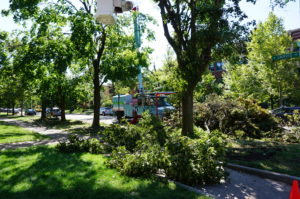
Removing damaged trees in Chicago’s Rogers Park.

One lesser-known by-product of derechos is tornadoes, which can be spun off from the shelf cloud as it moves through an area. In Chicago, two tornadoes, one EF-1 in the Rogers Park neighborhood along Lake Michigan near the city line with Evanston, literally buzzsawed trees in an area of densely built multifamily housing and small

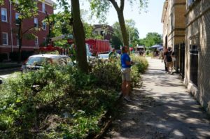
Insurance claims agents inspect building damage in Rogers Park.

businesses. A few days later, I visited the area to shoot photos that appear here. At first, driving up Greenwood Avenue, I wondered where the damage was. But as I drove further north and approached W. Jarvis Ave., the answer became starkly obvious. I could not drive beyond that corner because the street was blocked; Jarvis was one way going east, but Jarvis east of Greenwood was also blocked. City trucks were removing damaged trees. After finding a way to park without impeding traffic, I encountered insurance agents on the ground shooting outside photos of nearby buildings, presumably for damaged masonry. Any damaged cars had already been removed.

That tornado, and another that reportedly skipped across the Eisenhower Expressway (I-290) on the West Side, dramatically demolished for some an old urban myth that tornadoes don’t strike urban areas. People believe this for various reasons, including how they think tall buildings disrupt wind circulation, but trust me: I’ve been involved in disaster recovery long enough to know that tornadoes do not discriminate against smaller towns. Rogers Park is very urban. Tornadoes go where they please. This specific tornado eventually skipped out over the lake, becoming a waterspout. But it left its mark.

The storm, by the way, ultimately spun off at least 17 documented tornadoes, mostly in northern Illinois, but a few in Wisconsin and Indiana. All were either EF-1 or EF-0 on the Enhanced Fujita scale. But by far, most of the damage resulted from the straight-line winds themselves, which were often in the range of 90 to 100 mph, with a top measured speed of 126 mph in Atkins, Iowa, making them basically of tornado or hurricane strength. And they sped, over the course of a single afternoon, across all or parts of several states.

By 4:30, the storm had continued its march into northwest Indiana, where it finally petered out. But what happened along the way?

Iowans can attest that it functioned across much of their state like a Category 2, maybe even Category 3, hurricane. Lyz Lenz, a columnist for the Cedar Rapids Gazette, noted in a guest column for the Washington Post four days later that the winds had damaged “more than 10 million acres, or 43 percent, of the state’s corn and soybean crop.” The reduction in harvest in Iowa is likely to be between one-fourth and one-half. The heading on her column referred to the storm as an “inland hurricane” that most people had not heard about. The damage was massive enough to be visible in satellite images.

The damage was not just to crops on the ground, but to hundreds of millions of bushels in storage bins on farms and in commercial storage facilities, according to the Iowa Department of Agriculture. Toppled grain bins were a common site.

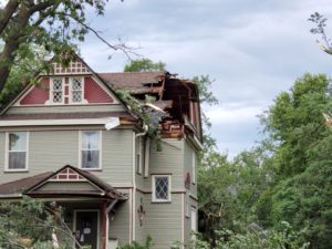
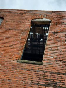
Damage to Chinese House roof in Grinnell. Photo by Rachel Bly.

Despite those staggering figures, that was only the beginning. Between Indiana and Iowa, four people died from either falling trees or electrocution, and, in one case, a mobile home tipped over by high winds. Losses of electric power affected approximately 585,000 Iowans, or roughly 20 percent, while 1.9 million lost power in neighboring Illinois. Tree damage in Linn County totaled in the hundreds of thousands, and most buildings suffered anywhere from mild to catastrophic damage. In small towns, like Grinnell, building damage and tree damage to cars was also extensive. Here, I wish to thank Rachel Bly, director of Conference Operations and Events for Grinnell College, for sending me dozens of photographs she shot after the event. Bly, I might note, has a certificate in emergency management from Park University in addition to her MPA from Drake University. The images she shared help convey some reality to the trauma that occurred. Hundreds of other small communities suffered similar impacts. Not surprisingly, Gov. Kim Reynolds issued a state disaster declaration by August 14 for 25 counties, and has sought a federal declaration from President Trump, citing an estimated $4 billion in damages. By August 19, Trump had signed a declaration for Public Assistance (PA) but not Individual Assistance (IA) for Iowa. PA provides aid for restoring public infrastructure, such as roads and bridges and community facilities, while IA provides direct aid to individuals for reasons such as loss of housing.

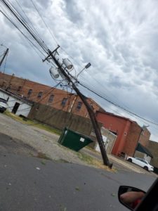
Power line damage in Grinnell. Photo by Rachel Bly.
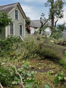
Photo by Rachel Bly

Roof seen through the window. Photo by Rachel Bly.

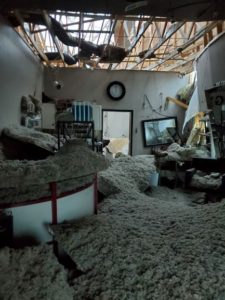
Inside a damaged salon in Grinnell. Photo by Rachel Bly.


Derechos as a Natural Hazard

All this raises the question of what we know about derechos as a wind-related hazard. I will confess that I spent most of my life never having heard the word, let alone understanding what it meant. It is not the most common occurrence, but it certainly ranks among the most destructive. To my surprise, I learned from Wikipedia that the term was coined in 1888 by a German-American scientist, Gustavus Detlef Hinrichs, who had emigrated to St. Louis just before the Civil War. He wrote in the American Meteorological Journal about a storm that struck Iowa in 1877 and described its unique characteristics. Nonetheless, even in the Midwest today, many people are unfamiliar with the term—until they hear it on the news, as they did on August 10 amid storm warnings.  

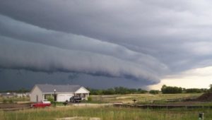
The gust front “arcus” cloud on the leading edge of a derecho-producing storm system. The photo was taken on the evening of July 10, 2008 in Hampshire, Illinois. Credit: Brittney Misialek. From National Weather Service website.

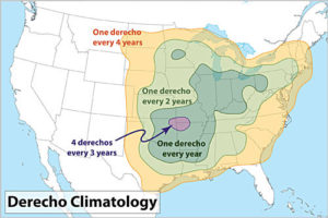
There are several types of derechos, but the National Weather Service describes a derecho as a “widespread, long-lived windstorm that is associated with a band of rapidly moving showers as thunderstorms.” More specifically, it defines the phenomenon as a swath of damage that “extends more than 240 miles (about 400 kilometers) and includes wind gusts of at least 58 mph (93 km/h) or greater along most of its length.” In plain English, this is a huge, regional storm, not some localized thunderstorm. It exhibits straight-line winds that can be at least double the minimum in the definition, and the August 10 event involved winds far above 58 mph in most locations. Like all such storms, it is a product of unstable atmospheric systems, in this case typically involving a bow-shaped front in a large squall line.

The storms are typically a mid-latitude phenomenon, making North America and the Midwestern U.S. particularly susceptible, but they occur elsewhere in the world as well, including southern latitudes (southeastern Brazil and Argentina), South Africa, China, and even eastern Europe, where a derecho struck parts of Estonia in August 2010, and near Berlin in Germany in 2002. The August 10 event was not the first one I have witnessed in Chicago—another struck in July 2011 and disabled electric power for nearly a million people—but it was certainly the largest in a long time.

70% of all derechos occur between the months of May-August (the warm season). The other 30% occur during the cool season. From National Weather Service website.

As a mitigation planning response, almost no hazard mitigation plan (produced for FEMA approval as a condition of eligibility for federal hazard mitigation grants) for any state or community east of the Rockies (with the possible exception of Florida) should fail to identify derechos as a potential hazard. Moreover, especially in the Midwest, it may be time for states and communities to reexamine their building codes for wind resistance as a means of limiting future damages from derechos. Finally, it may also be time for many communities to examine more closely their urban forestry programs for adequate attention to hazardous tree management. That does not mean refusing to plant trees or removing them unnecessarily as a mindless precaution. It does mean engaging professional urban foresters in an assessment of the urban tree canopy with an eye to ensuring forest health and removing those trees that are most likely to fail under severe wind pressure. Already, the call has arisen for such reforms in Chicago. It is time for planners, environmentalists, disaster professionals, open space advocates, and concerned citizens to seize the moment while they have the public’s attention.

Jim Schwab

The People Affected by Harvey

A few days ago, in my last post, I wrote that Hurricane Harvey would last a few days, but the recovery would last years. However agonizingly long Harvey appears to be taking to inflict its misery on the Texas Gulf Coast, and now parts of southern Louisiana, it will go away. And then the real marathon will begin. People will have to face the necessity of reconstruction, both as individuals and as whole communities.

In writing about this now, I am crediting readers with a longer attention span than seems to be assumed of most Americans on social media today. I truly hope, however, that the news media does not forget about Harvey or the Gulf Coast as the recovery process grinds on over coming months and years. Certainly, most residents of the Texas coast will have little choice but to bear with the process, and ideally, they will participate. Recovery needs to be as participatory as possible to succeed fully.

FEMA teams managing the distribution of water, and meals for hundreds of semi-trucks at an incident Support Base in Seguin, Texas. Photo by Dominick Del Vecchio – Aug 29, 2017 (from FEMA website) 

It will not always be a pretty picture. The news media in recent days have been full of photographic and video evidence of the best aspects of humanity—people in boats rescuing neighbors and strangers alike, public safety personnel risking personal safety as they save people from flooded homes and transport them to shelters, and other heroic acts away from cameras and too numerous to count. People from other states and nations will contribute to disaster-related charities to help people they have never known and may never meet. Politics and race and religion will all take a back seat to saving lives and reducing suffering. For just a brief moment in history, we can stop shouting at each other long enough to care for each other and be proud of one another.

Several years ago, Rebecca Solnit produced an intriguing book, A Paradise Built in Hell, that explored many of the positive community-building relationships that emerge when people are challenged by adverse circumstances such as major natural disasters. It is a journalistic journey through the informal alliances and communities created by people under what seemingly are the worst possible conditions, but which challenge our humanity and force us to consider how we value those around us. It is an optimistic book that forces readers to rethink what it means to live through a disaster. I have always hoped that it would spark similar efforts among academic researchers, particularly in the social sciences, to study this phenomenon more closely. I think that is happening to some extent, but perhaps not nearly enough.

The Texas Gulf Coast communities stricken by Harvey will need as much of that spirit as they can muster to produce successful long-term recovery. Recovery takes years because, while no one wants to delay rebuilding unnecessarily, hasty rebuilding that fails to consider the failure points that allowed destruction to occur is even more undesirable. Under considerable time pressures, which researchers Robert Olshansky and Laurie Johnson, both wonderful friends of mine, have notably referred to as the problem of “time compression” in disaster recovery, planners and local and state officials will need to meet with constituents, hear their concerns, explain both the obstacles and opportunities involved in reconstruction, and ideally, inform the public process to help lead to a better outcome. During this time, minor and modest repairs may go forward while the bigger decisions, like where to buy out damaged properties, how to rebuild infrastructure and to what new standards, and how to produce a stronger, more resilient community to handle future disasters may need to undergo vigorous debate.

I point this out because, inevitably, and despite Solnit’s rosy scenarios in the context of community building, tempers will rise and people will need to iron out significant differences and widely varying perceptions of the causes of, and solutions to, the damage that occurred. There will surely be some debate about Houston’s sprawling development patterns and relative lack of development controls. There may be debates about strengthening building or zoning codes or, in Houston, the absence of zoning. If there is any echo of Hurricane Sandy, there may be discussion of a greater role for green infrastructure in mitigating hazards, though that alone would have made only modest difference in the flooding from Harvey, but it might have helped.

More importantly, people will have undergone trauma that will make them deeply and justifiably emotional about the disruption of their lives. They will bring that trauma, and a need to vent and share their fears and anger, to public meetings. Public officials will need to exhibit patience because, as Christine Butterfield, another good friend who served as community development director in Cedar Rapids, Iowa, during and after the 2008 floods, has noted, those public gatherings will be therapeutic. People may cry, they may yell, they may accuse. Most of all, they need to know that someone else wants to hear and share their pain. They want to know that someone cares. Once most have achieved that comfort level, they may be ready to move forward and discuss options for recovery. But first, community leaders must build trust.

Some people may never trust, and the rest of the community may need to move on. Life is not perfect. Human beings are not perfect. Recovery cannot wait forever, but it must demonstrate compassion and a commitment to social equity.

In a few weeks, the entire process will begin, and people will decide what role they want to play. Leaders will arise in unexpected places. Just last week, my students at the University of Iowa School or Urban and Regional Planning, during a field trip with which I launch my course on “Planning for Disaster Mitigation and Recovery” every year, heard from United Methodist pastor Clint Twedt-Ball, a co-founder and executive director of Matthew 25, a community organization that arose from almost nothing after the 2008 floods in Cedar Rapids to help rebuild 25 blocks of downtrodden neighborhoods in the city, raising money but also making tough decisions about what would work and what would not. Nine years later, his organization is still working to make a difference. Before 2008, Clint would confess, he knew next to nothing about floods or community development. My guess is that now he could nearly write a book. Who knew?

Watch Houston, and Rockport, and Corpus Christi, and all the other cities on the Texas Gulf Coast for both surprises and struggles, and mostly for deep human engagement in solving massive redevelopment problems the likes of which most of us will never have to confront. And be ready to cheer them on when good things happen. They are likely to need the encouragement from time to time.

Jim Schwab

Iowa Faces Its Fluid Future

It was just five years ago that Iowa was awash in flood water. Many people are familiar with the dire scenes from Cedar Rapids, where record floods forced the evacuation of 10 percent of the city’s residents on June 13, 2008, swamping the downtown and causing extensive damages. Plenty of other Iowa communities suffered as well, however. Cedar Falls, 90 miles north of Cedar Rapids along the same Cedar River, struggled to contain flood waters that overwhelmed its north side and almost overtook its downtown. To the southeast, Iowa City watched the Iowa River flood major University of Iowa buildings like Hancher Auditorium and the Iowa Memorial Union and learned, maybe, that the university had invested in too much real estate on the riverfront. Across the state, the rivers swelled and dozens of small towns coped with mud, pollution, and lost memories.

On Friday, May 31, I joined a panel on water management policy at “Five Years Out,” a one-day conference at the National Czech and Slovak Museum and Library in Cedar Rapids that examined Iowa’s past and future with regard to these issues. As if on cue, nature responded by sending a line of thunderstorms to assault the area the day before, accentuating the moisture in soil that had already become a huge, wet sponge throughout the spring. The Dubuque St. entrance to downtown Iowa City from I-80, always a flash point because it closely parallels the Iowa River, was closed before the day was out. As Yogi Berra would have said, it seemed like déjà vu all over again. Fortunately, the sun triumphed on Friday, and Iowa got a reprieve. Summer could still be challenging.

What I found most revealing was the information shared by William Gutowski and Rick Cruse of Iowa State University. Gutowski teaches in the Department of Geological and Atmospheric Sciences and has been tracking data on Iowa’s changing climate for some time. He discussed the seeming contradiction of Iowa suffering both increased propensity for extreme precipitation events, leading to flooding, and increased propensity for drought. The two possibilities are not mutually exclusive or contradictory, however. Higher average temperatures lead to a situation in which the atmosphere is capable of containing higher amounts of moisture because warmer air can hold more moisture before being forced to dump its load. That also means that storms become worse when they do occur. Gutowski showed that average annual precipitation in Cedar Rapids had increased between 1890 and 2010 from 28 inches to 39 inches per year. If global warming pushes that trend even further, Cedar Rapids and the rest of Iowa can expect more extreme weather of both types over time. That means, in part, that the so-called 100-year flood event, or that flood having a repetitive one percent chance of occurring each year, may well become more frequent. The record-breaking flood of 2008 could well become more common. The only thing saving the city in the future is the fact that it has given the Cedar River “room to breathe,” as various speakers put it, through the city’s acquisition of more than 1,300 flooded parcels in the floodplain since 2008, thus removing a good deal of vulnerable housing from the prospect of future damage. Rick Cruse, an agronomist, accentuated Gutowski’s data with significant data on how land use and land cover affect water infiltration into the soils and water tables. Forcing increased runoff with vegetation or impervious surfaces that do not hold the water as well serves to increase our propensity for flooding. As it turns out, woodlands do the best job of absorbing rainwater, while ubiquitous Iowa crops like corn and soybeans have a more questionable track record. The result is that Iowa may need a serious debate about farming practices, including crop choices and rotations, in order to confront its flood threat adequately for the future. That will not be an easy debate because it affects serious economic interests in the state. Yet it may be the most important debate Iowa can have about its climate future.

The University of Iowa Public Policy Center, which presented the conference, will be posting the PowerPoint presentations and videotapes of the sessions on its website in coming days. For those the least bit serious about exploring the implications of these issues, I urge you to follow the link above and check it all out.

Jim Schwab