Facing Waterfront Hazards in Wilmington

Wilmington, a charming city of just over 100,000 on the far southern edge of the North Carolina coast, has taken some hits from coastal storms in recent years, most notably Hurricane Florence in 2018. Hurricane Dorian this year posed a minor threat but mostly left a trail of 14 identified tornadoes in its wake, a phenomenon familiar in the Southeast, though their association with hurricanes may be less well known elsewhere.

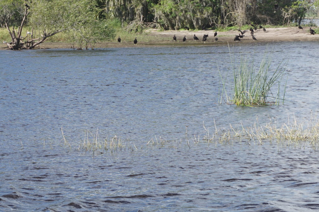
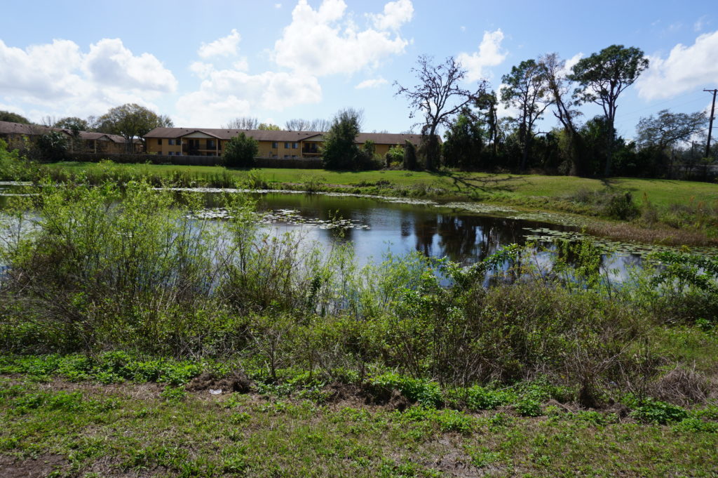
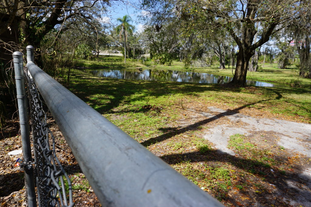
Wilmington Planning Director Glenn Harbeck, who I was told was one of the most knowledgeable people in town for the purpose, on October 8 took me on a boat tour of much of the city’s interior waterfront to let me see and photograph the area along Hewletts Creek, a stream feeding into the Atlantic Ocean behind the barrier island that includes the Masonboro Island Estuarine Reserve. Glenn and his wife have lived in Wilmington for 40 years, during which, he says, they have experienced a succession of hurricanes: Diana (1984), Bertha (1996), Fran (1996), Bonnie (1998), Floyd (1999), Matthew (2016), Florence (2018), and Dorian (2019).

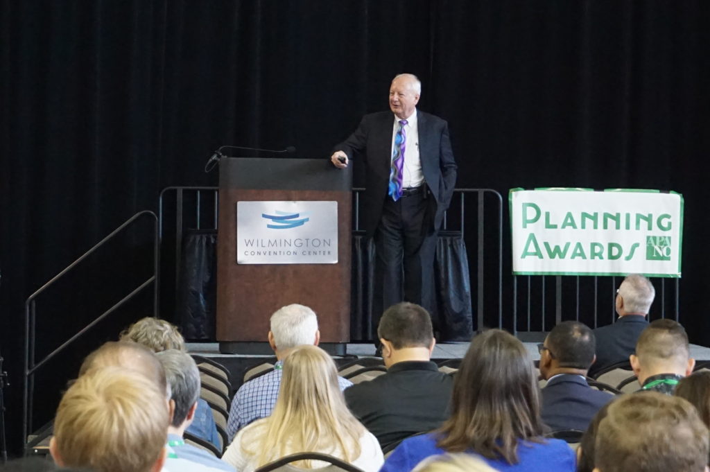
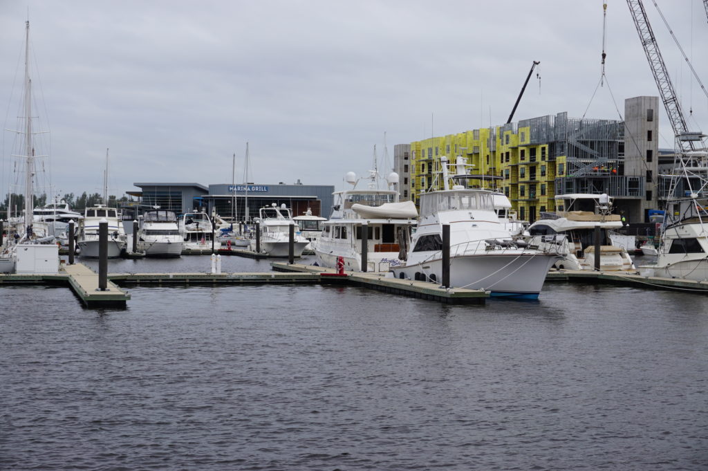
Why it has taken me this long to write about it is another matter related entirely to my own obligations and distractions. At the time, however, I was in Wilmington as the invited keynote speaker for the annual conference of the North Carolina chapter of the American Planning Association. That event was at the city’s convention center, which sits along the Cape Fear River, which basically serves as the city’s western edge, with suburban or unincorporated New Hanover County on the other side. Along with the adjoining Embassy Suites, the complex boasts a boardwalk that allows people to walk to restaurants and other venues in more historic quarters of the city. I joined a party of a dozen at a nearby seafood restaurant, The George on the River, and got to see much of it. Some of the boardwalk appears to need work, but I was not clear on whether that was due to hurricane damage of work in progress. But I can give The George five stars. The food was wonderful and a credit to southern coastal cuisine. (I enjoyed crab-topped salmon with garlic mashed potatoes and spicy collards. I gladly recommend it.) Added appeal derived from the outdoor seating that made for a pleasant evening setting.

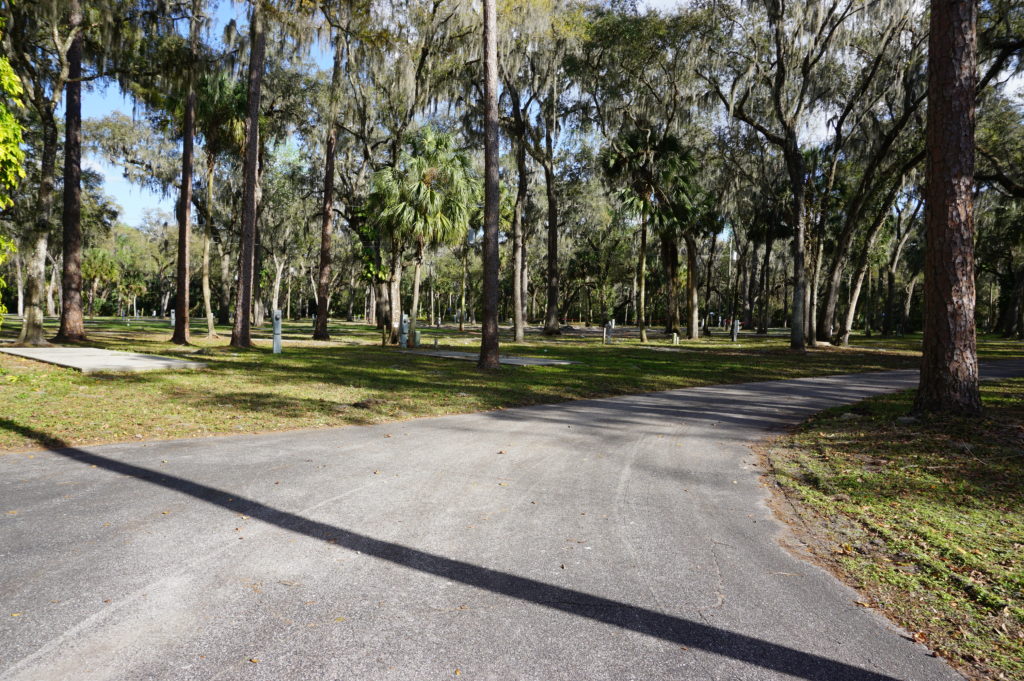
But all that followed the boat tour, which came in the late afternoon after a delayed arrival in Wilmington following a long layover in Atlanta on the way from Chicago. The weather had been uncertain, and Glenn was a bit concerned about concluding the trip before it turned rainy or inhospitable, although it never did. It was simply a bit chilly, but my photos have that overcast, gray-sky look as a result.

Compared to some prior tours I have taken of disaster sites, this one was relatively brief with modest expectations. Nonetheless, there are always learning opportunities, and I had never visited Wilmington before. Touring by boat allowed a different perspective than by land. Certain factors became readily apparent, with Glenn supplying ample explanation.

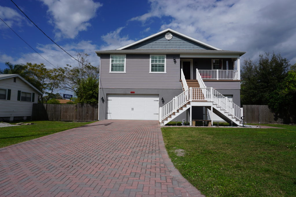
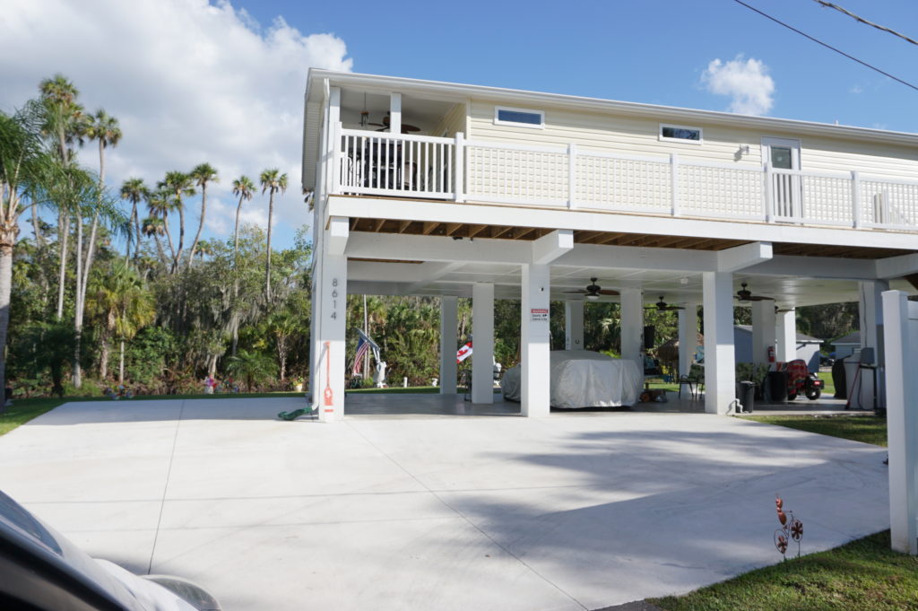
One, to be expected, was that, despite the clear dangers and mitigation challenges associated with a waterfront near the ocean in a region frequently affected by coastal storms and hurricanes, housing along Hewletts Creek remains attractive to its owners and has gained value as a result. These are people who love their boats and their access to the water, and the storms are simply part of the environment, much like a snowstorm in Chicago. Whether everyone takes all the appropriate precautions to protect those properties may be another matter, but most are at least aware of the challenges they face when hurricanes move toward North Carolina.

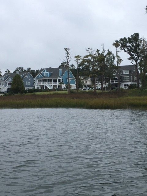
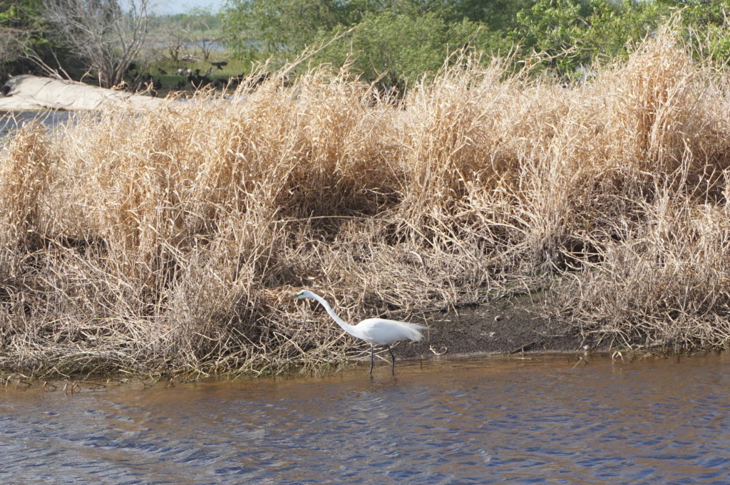
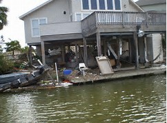
Because access to the water is a prized asset, most properties include piers, although shared piers are becoming more common, according to Glenn, presumably because of reduced costs and environmental impact. Those piers, however, have typically taken a beating in big storms, and Hurricane Florence contained some solid punches. One problem, he informed me, is that the buoyancy of the wood is the enemy of the piers’ survival because, as the storm surge rises and the piers rise with it, they are bent and twisted and collapse. In other words, the buoyancy of wood works against them. The photos provide ample evidence, but Glenn also told me that some had been repaired in recent months; if I had come three months earlier, the destruction would have been more evident. Past adaptation in some places was to rebuild the piers higher than before to move them above likely wave levels, but frequent storms and high storm surges have sometimes obviated the effectiveness of this approach. Instead, some pier owners are adapting with the use of Titan decking, which uses polypropylene plastic to stabilize the piers during future storms.

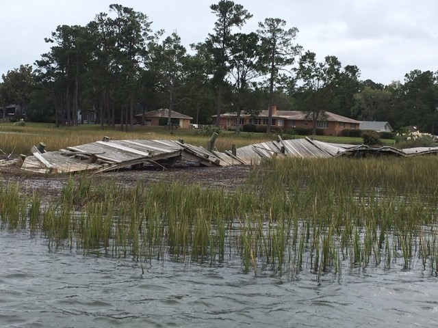
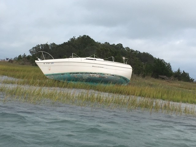
There were also, a year after Florence, remaining indications of the damages suffered to the boats themselves, which can easily be tossed about by winds and waves. We encountered one of those (below) toward the end of the tour.  

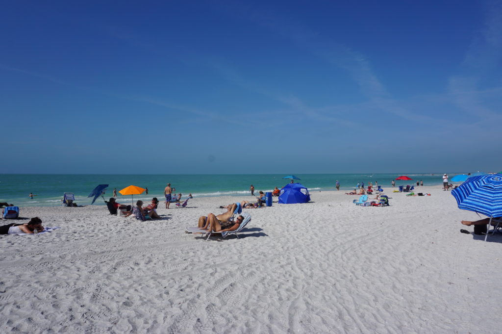
It should be noted that, although it is inside Wilmington, Hewletts Creek has a much more rural or suburban feel than the Cape Fear River waterfront, which is near the urban heart of the city and its downtown. The riverfront is not primarily residential but encompasses a variety of commercial uses, including hotels and a large marina. In contrast, the waterfront along Hewletts Creek consisted predominantly of private residential property.

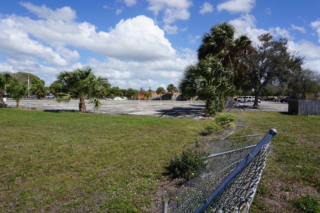
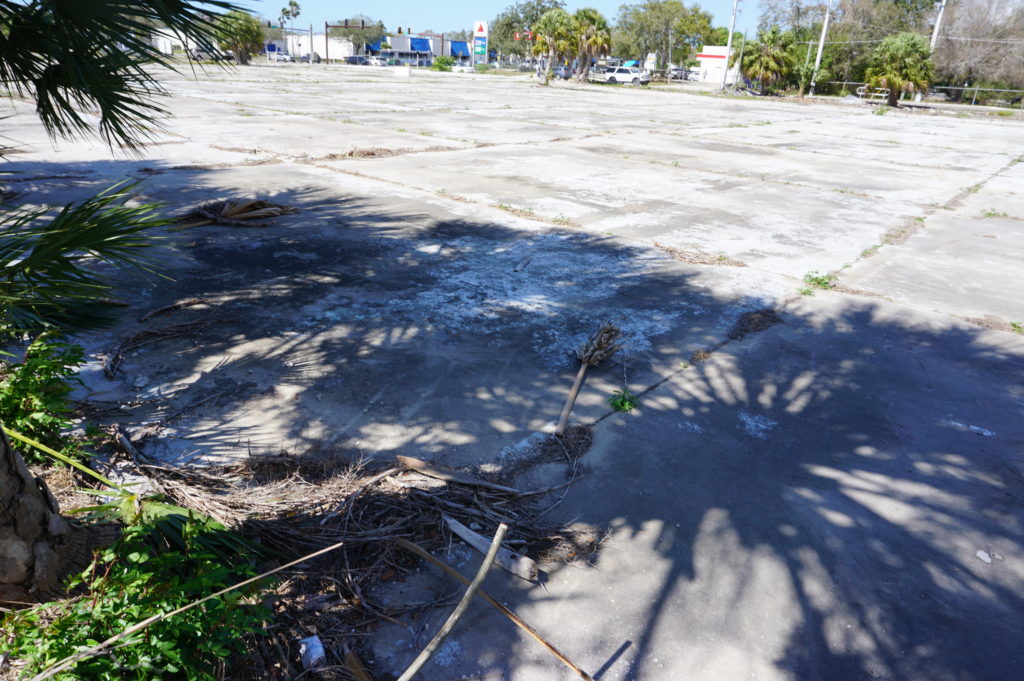
I do not wish to leave the impression from this glimpse of Hewletts Creek that what happened there is the extent of the impact of Florence. Although I did not have time on this trip to get a thorough tour of the city, I did receive other information from Glenn and from Christine Hughes, a senior planner with the city for Comprehensive Planning, Design, and Community Engagement. From her, I learned that Wilmington’s working and low-income populations sustained a large hit on their affordable housing stock with the loss of approximately 1,200 apartment units. In September, the Wilmington City Council approved $27 million worth of bond issuances for the Wilmington Housing Authority. A big part of that involved the closure of Market North Apartments on Darlington Avenue, which will be rebuilt. That closure forced evacuation by more than 1,000 residents. Wilmington will be recovering from Florence for some time to come. The cost and numbers of people affected in this housing redevelopment underscore the solemn fact that often low-income and minority populations suffer the greatest impacts of natural disasters. Our communities are not whole unless and until we give them high priority in recovery planning.

It is also worth knowing that the quest for coastal resilience is not new to Wilmington, which has engaged with federal and state agencies for some time, as illustrated in a 2013 report on a U.S. Environmental Protection Agency pilot project on community resilience. Glenn Harbeck has been in his current position for more than seven years after a long period of consulting and knows well the direction the city needs to take, but it is a long road. Residents can learn a great deal about the progress of infrastructure recovery projects from the city’s online map tracking such efforts, which include street and sidewalk repairs and stormwater management. Recovery is a complex process, as Wilmington knows well, and future storms, climate change, and sea level rise will all surely add to the challenges that lie ahead.

Jim Schwab

Great Lakes Merit Protection

I grew up near the shores of Lake Erie, in suburban Cleveland. After a seven-year stint in Iowa and Nebraska, I ended up in Chicago, where I have lived since 1985. The Great Lakes have been part of my ecological and geographic consciousness for essentially 90 percent of my lifetime. As an urban planner, that means I am deeply aware of their significance on many levels.

It will surprise no one, then, that as a planner who has focused heavily on environmental and natural hazards issues, I have been involved in projects aimed at protecting that natural heritage. As manager of the Hazards Planning Center at the American Planning Association (APA), I involved APA as a partner with the Association of State Floodplain Managers (ASFPM) as ASFPM developed its Great Lakes Coastal Resilience website with National Oceanic and Atmospheric Administration (NOAA) support. Later, I prepared a successful grant for support from NOAA’s Sectoral Applications Research Program for a project on integrating climate change data into local comprehensive and capital improvements planning. In that project, APA collaborated with the Chicago Metropolitan Agency for Planning and the University of Illinois. That project, which involved work with five pilot communities in the Chicago metropolitan area, was (and still is) ongoing when I left APA at the end of May 2017. The aim was to develop applicable models for such planning for other communities throughout the Great Lakes region.

It is thus always encouraging to see others pick up the same mantle. It was hardly surprising that the Environmental Law & Policy Center (ELPC), a long-time Chicago-based staple of the public interest community, would see fit to do so. On March 20, in concert with the Chicago Council on Global Affairs, ELPC released “An Assessment of the Impact of Climate Change on the Great Lakes,” with 18 scientists contributing to the 74-page report. I spoke two weeks later with Howard Learner, the long-time president and executive director of ELPC, about the rationale and hopes for the report.

The impact of adding one more report to the parade is cumulative but important. Learner explained that national studies, particularly the National Climate Assessment, mention regional impacts of climate change, but that drilling down to the impacts on a specific region and making local and state decision makers aware of the issues at those levels was the point. Thus, he asked Don Wuebbles, an atmospheric scientist at the University of Illinois and a science adviser to ELPC, to assemble a team of experts for the purpose. Wuebbles recruited most of the team, with the goal not only of identifying problems but of developing or pinpointing solutions. Repeatedly, Learner emphasized the public policy role of ELPC as a “problem-solving” institution. The intended audience was governors, provincial ministers, congressional delegations from Great Lakes states, and other public officials, providing them with an assessment of the state of the science concerning the Great Lakes.

I won’t even attempt to review all the data in the report, but certain points are essential to an adequate public understanding. For one, the Great Lakes are simply huge and constitute a very complex ecosystem in a heavily populated region of more than 34 million people in the U.S. and Canada, the vast majority of whom repeatedly express support for protection of the Great Lakes in public opinion polls. It is the largest freshwater group of lakes on the planet, and second largest in volume. It is a binational ecosystem that demands cooperation across state, provincial, and national boundaries. It is home to 170 species of fish and a $7 billion fisheries industry. It has long been home to one of the most significant industrial regions of both nations. What happens here matters.

The term “lake effect” is most often associated with the Great Lakes because their sheer mass has a measurable impact on local and regional weather patterns. Winds pick up considerable moisture that often lands downwind in the form of snowstorms and precipitation. For instance, any frequent visitor of farmers’ markets along the Great Lakes is likely to be aware of western Michigan’s “fruit belt” offerings of apples, cherries, pears, and other crops dependent on the lake effect.

Figure 3. Observed changes in annually-averaged temperature (°F) for the U.S. states bordering the Great Lakes for present-day (1986–2016) relative to 1901–1960. Derived from the NOAA nClimDiv dataset (Vose et al., 2014). Figure source: NOAA/NCEI (Both images reprinted from report courtesy ELPC.

Figure 4. Projected change in annually-averaged temperature (°F) for U.S. states bordering the Great Lakes from the (a) higher (RCP8.5) and (b) lower (RCP4.5) scenarios for the 2085 (2070-2099) time period relative to 1976-2005. Figure source: NOAA/NCEI

The lake effect, of course, is a part of the natural system in a region carved out of the landscape by melting glaciers at the end of the last Ice Age. Recent climate change is another matter. The region has already experienced a 1.6° F. increase in average daily temperatures in the 1985-2016 period as compared to the 1901-1960 average. Those increases are expected to accelerate over the remainder of this century. It is not just temperatures that change, however, because changing weather patterns as a result of long-term climate change result in altered precipitation patterns. Summer precipitation is predicted to decline by 5 to 15 percent, suggesting some increased propensity for drought, while winter and spring precipitation will increase, producing an increased regional propensity for spring flooding. Increased intensity of major thunderstorm events will exacerbate the vulnerability of urban areas to stormwater runoff, resulting in increased “urban flooding,” often a result of inadequate stormwater drainage systems in highly developed urban areas. That, in turn, has huge implications for municipal and regional investments in stormwater and sewage treatment infrastructure. In addition, heat waves can threaten lives and public health. Public decision makers ignore these implications at the fiscal and physical peril of their affected communities.

Among those impacts highlighted in the report is the increased danger of algal blooms in the Great Lakes as a result of changing biological conditions. The report notes that the largest algal bloom in Lake Erie history occurred in 2011, offshore from Toledo, Ohio, affecting drinking water for a metropolitan area of 500,000 people.

There is also danger to the stability of some shoreline bluffs, an issue highlighted on the Great Lakes Coastal Resilience website, as a result of reduced days of ice cover during the winter. While less ice cover may seem a minor problem to some, in fact it means changes in water density and seasonal mixing patterns in water columns, but it also means the loss of protection from winter waves from storm patterns because the ice cover prevents those waves from reaching the shore until the spring melt. The result is increased shoreline erosion.

All of that harks back to the central question of my interview with Learner: What do you hope to achieve? “The time for climate action is now,” he insisted, noting that the Trump presidency has been “a step back,” making it important for cities and states to “step up with their own climate solutions.” Learner hopes the report at least provides a “road map” for governors and Canadian premiers to focus their actions on the impact of climate change on the Great Lakes, such as “extreme weather events.”

Curiously, one arena in which new action may be possible is the city of Chicago itself, which on April 2 elected a new mayor, Lori Lightfoot. Media attention has focused on the fact that she is both the first gay mayor and the first African-American female mayor in the city’s history, but equally significant is her history as a former federal prosecutor who campaigned against corruption. Learner notes that outgoing Mayor Rahm Emanuel convened a Chicago Climate Summit in November 2017, and that ELPC is now “looking to Mayor Lightfoot to step up Chicago’s game” to benefit both the local economy and environment with a stronger approach to climate change.

The same can be said, of course, for numerous other municipalities choosing new leadership and for the new governors of the region, including J.B. Pritzker in Illinois. They all have much work to do, but an increasing amount of research and guidance with which to do it.

Jim Schwab

Romping through South Florida

Two weeks ago, I spun a narrative about hazard mitigation in Hillsborough County, Florida, based on both prior knowledge and a personal tour conducted by long-time colleague Eugene Henry. Today, a full month or more after that visit, I add notes about touring the Sarasota area with my personal friend and high school classmate, David Taylor.  David is a Vietnam veteran and professional photographer who was part of the Brecksville (Ohio) High School class of 1968. Yes, we graduated in the middle of it all in the late 1960s.

Unlike me, David was drafted into the army. I maintained a student deferment initially, then went untouched by the draft lottery, which reached 125 the year I surrendered my deferment. Numbers were based on the number pulled for your birth date. Mine was 135. Such was the luck of the draw in those days. In less than two months on the ground in Vietnam, David was badly injured in a mortar explosion, evacuated to a hospital and sent home. His injuries were more than severe enough to terminate his service. He spent months in rehab. When it became clear that cold weather aggravated his disabilities, he moved to Florida. He has lived there ever since. He and his wife, Linda, now live in a small home in a subdivision near the water in Sarasota.

His long tenure in Florida has allowed him ample time to learn the sights and sounds of his adopted home. One thing my wife and I learned from staying with him for five days is that Dave is relentlessly curious. He attended and videotaped my February 22 lecture for Florida Atlantic University in West Palm Beach, then loaded the 37-gb high-res recording on a flash drive. Download it to your laptop when you get back, then reload the flash drive with as many documents and photos about your work as will fit on it, he told me.

I don’t think Dave completely understood. I could give him nearly everything I have and never fill up a drive of that size. But Dave lives in the film world, and all the reports I have downloaded as PDFs and all the still photos I have ever taken will never equal more than a fraction of that memory. I gave him all I could.

More importantly, however, Dave took us on some tours to take maximum advantage of the two days we had remaining after returning from West Palm Beach (a 3 ½-hour drive across the southern interior of Florida). From an environmental standpoint, it is important to know that Florida is a more diverse state than outsiders may realize and that, due to rapid urbanization in the past few decades, it also faces environmental challenges and threats of significant proportions. The state has been wrestling with many of these for a long time. The fate of the Everglades triggered one of the most notable environmental policy battles in American history, but there are many smaller issues as well, many engendering serious public health concerns as well.

One to which Dave took us, new to me, was the American Beryllium site on Tallevast Road in Sarasota. Now abandoned, the site hosted a manufacturing facility for machine parts of the Loral Corporation, parent company of American Beryllium, for more than 30 years until 1996. The operations created beryllium dust that contaminated the soil and groundwater. Lockheed Martin acquired the plant in 1996 and closed it down. Subsequent investigations discovered the contamination and documented the need for cleanup of what was then a brownfield site. By 2008, the Agency for Toxic Substances and Disease Registry (ATSDR) of the U.S. Department of Health and Human Services completed its own assessment of the health risks, concluding that, while there was a wide margin of possibilities given the combination of contaminants including trichloroethylene in the beryllium-containing metals on the site, there was a definite public health hazard. Previous use of groundwater by local residents and employees, which by then had ceased, posed a credible risk of kidney cancer, liver cancer, leukemia, and lymphoma. By 2004, all nearby residents had been using municipal water, but the long-term legacy could not be ignored.

Fence provides no real security for American Beryllium site.

The site today is mostly an empty lot next to a golf course. There is a fence around it that, frankly, is not well maintained, but how much danger the site poses at this point, I do not know. The empty lot looks rather forlorn, yet the area around it contains a fair amount of operative commerce. When, if ever, the site will be ready for reuse remains to be seen. Mostly, it is a sobering reminder of our past use and misuse of such toxic materials in manufacturing processes and the problems they often leave behind. Beryllium is a divalent element, a strong metal with high thermal stability that is useful in aerospace applications, certainly of interest to a firm like Lockheed Martin. But often in the past, manufacturing firms took inadequate measures to prevent the sort of pollution that materialized on this site. The result is a long-standing eyesore for Sarasota.

But there were other things to see in the area, like Myakka River State Park, which features a wildlife preserve that is worth visiting and attracts many visitors. Park officials are often available to explain the wildlife you are seeing, such as snowy egrets, cypress trees, vultures, and, of course, alligators. The vultures seemed exceptionally calm and contented, so Dave and I concluded that they had already had their fill for the day.

Vultures line the shore of the river.

Unable to stop myself—we have a growing collection of souvenir mugs in our cupboards—I bought a reasonably priced mug from the gift shop with the state park logo embedded in the ceramic. Our children one day, when we are no longer breathing, may wonder “Myakka what?” and pass it on to the nearest Salvation Army store, but we will enjoy it for the next 20 years, or until one of us accidentally drops it on the floor (whichever comes first). Who knows when we will be back?

David has vivid memories of his Vietnam experiences, and to some extent, like most Purple Heart veterans, of the trauma involved in his experience. This remains no small part of his semi-retired life, in which he is also enrolled in film and history classes at nearby State College of Florida, and continues part-time photographic work. So, he took us to the Sarasota National Cemetery, where veterans may choose to be buried, and where he has attended and participated in numerous ceremonies. Kiosks exhibit photos documenting the veteran experience as far back as World War I but as recent as Afghanistan. The growing Florida population including the elderly means a growing number of veterans for whom the cemetery may be a final resting place. It is always a sobering encounter with reality to visit such a place—to realize how many lives are affected, for good or ill, by the nation’s struggles throughout our history. One does not have to agree with a particular war, and I have certainly disagreed with some, to recognize the magnitude of the sacrifice of those in uniform and the respect they deserve. Just gazing out at a wide field of gravesites should be enough to convey the message. War is no trifling thing. We invariably owe our veterans a serious explanation when we send them into battle.

On that Saturday evening, however, it was time for fun, and Dave and Linda took us to a comedy club, McCurdy’s Comedy Theater and Humor Institute, which was great fun, and on the way back to their home, we stopped at the “Kissing Sailor” statue, developed from an iconic photo of a sailor embracing his beloved on the streets of Manhattan as the official surrender of Japan and the end of World War II were announced. Each couple shot photos of the other standing beneath this unique feature of the urban landscape in Sarasota.

Dave and Linda beneath the Kissing Sailor.

The next morning, with our free time waning before driving to the Tampa International Airport, we all made one last stop, at the Ken Thompson Park. What would Florida be without its beaches? Ken Thompson, the namesake of the park, was a long-time city manager in Sarasota. More importantly, the beach, like the rest of southern Florida, was 84° F. and sunny, with plenty of people resting on the sand and taking in the scenery of the Gulf Coast. Not far away are opportunities to follow a boardwalk through a small forest. It is small wonder in such a setting that Florida might beckon to anyone used to northern weather in the winter, but duty called, and Chicago is very nice once spring arrives.


In fact, I took so long to write this story that it is here. Tomorrow I plan to take time to ride my bicycle on the 606 Trail, whose story I told in this blog when it opened nearly four years ago. Snow? It happens, but it’s over for now, just a fading memory.

Jim Schwab

Mitigation Challenges on the Florida Gulf Coast

Hillsborough County is a dense metropolitan area, anchored by the city of Tampa. Tampa and nearby St. Petersburg, in Pinellas County, sit on opposite shores of Tampa Bay, a 400-square-mile expanse of water connected to the Gulf of Mexico. Across that gap sits the Sunshine Skyway Bridge, a magnificent and scenic section of I-275. On a sunny day, it displays coastal Florida in all its glory.

Eugene Henry, like anyone else, enjoys those sunny days, but he also worries about what may happen when the region suffers inclement weather. As Hillsborough County’s Hazard Mitigation Program Manager, it is his job to think about how well the area will fare under the impact of natural and other disasters, which can include hurricanes, floods, tornadoes, sinkholes, and wildfires. At least the first two are complicated by sea level rise, and one can easily argue that climate change in a broader sense may well influence the damage from wildfires. For those uninitiated in the particulars of Florida’s natural environment, wildfires are a recurring feature. In what is ordinarily such a lush environment fostered by rain and abundant sunshine, it takes only one drought year amid high heat to turn dense vegetation into a tinderbox. It has happened before, repeatedly.

But the biggest concern, by far, is the arrival of the Big One, the high-intensity hurricane that the county readily admits it has escaped in recent decades. In its Post-Disaster Redevelopment Plan (PDRP), the county states forthrightly that this is merely a matter of good fortune and that planners fully understand that the day will surely come—and that they had best be ready for it. Disaster resilience in the face of hurricanes is not a matter to be taken lightly with 158 miles of shoreline along Tampa Bay, numerous rivers and streams, and numerous vulnerable, low-lying areas. Absent serious attention to mitigation, damages from a Category 4 or 5 hurricane, or one like Harvey that stalls and dumps voluminous rain on an urban area, could become catastrophic.

But Tampa and Hillsborough County have been very fortunate. The last Category 3 hurricane struck the area in 1921. What may have been a Category 4 struck in 1848, though wind speed measurements were primitive at the time, and the U.S. had no official records yet. According to the county’s Local Mitigation Strategy, that storm “reshaped parts of the coast and destroyed much of what few human works and habitation were then in the Tampa Bay area.” Tides rose 14 feet. Tampa was still a small city then, and Gene Henry wonders about the staggering losses that might occur with a comparable event today.

I had long wanted to visit the area to see in person how these issues are being addressed. I have known Gene for a long time, and I have read the county’s PDRP, an extensive document laying out the county’s preparations for recovery from disasters. But I had never been to Tampa. As the result, however, of a personal invitation from a high school classmate, David Taylor, who now lives in Sarasota, my wife and I flew to Tampa February 20 and stayed with Dave and his wife, Linda, for five days. Sarasota is about one hour’s drive south of Tampa. As part of the trip, I arranged to meet with Gene the day after we arrived and tour the county to see the hazard mitigation projects underway there. I also delivered a one-hour lecture the following afternoon in West Palm Beach, on behalf of Florida Atlantic University, as part of a two-hour program that included a panel discussion following my talk on “Recovery and Resilience: Facing the Disasters of the Future.” Not one to skip a learning opportunity, Gene drove four hours from Tampa to attend the program.

But back to Hillsborough. My wife and I met Gene at the county’s Emergency Operations Center (EOC) around mid-morning, hopped in his county truck, and took off. Our first stop was the Florida Center for Design + Research, housed in the School of Architecture + Design at the University of South Florida (USF), Gene’s graduate alma mater. The school features an urban planning program where he wanted us to meet Professor Brian Cook. Planning students often take studio classes, which involve design or research work on real-life community problems. Students learn to define a community design or policy issue, work with clients, and try to produce solutions that will be of some practical value to the community they are serving. They typically work in teams. In this case, students were applying geographic information system (GIS), or mapping, skills to determine areas of high vulnerability to flooding and sea level rise in less affluent neighborhoods. Gene’s county office collaborates with USF instructors to identify areas of practical concern for the students’ work. The photos show some of the design work the students have done, the best of which is often displayed in poster sessions at state and national professional planning conferences.

Posters (above and below) from the USF design studio

The most encouraging aspect of that visit was, for me, the mere fact that the students are engaging with such a pressing problem. I have researched the issue of hazards and climate change in the planning curriculum for both undergraduate and graduate degree programs in urban planning, and most such programs are lacking in this respect, a situation that is disserving the planners of tomorrow who must be well trained to come to grips with these challenges in whatever communities they end up serving. But a growing number of students are getting such training—I have myself been teaching such a course at the University of Iowa since 2008—and southern Florida is as good a laboratory as they could wish for. To see collaboration between a county agency and USF graduate students and faculty is a most welcome note.

But Gene had other places to take us in the afternoon, besides, that is, the Cuban-themed La Teresita restaurant where we ate lunch—a place I am willing to recommend if you ever visit Tampa.

First up in the afternoon was the University Mall area north of downtown Tampa and just east of I-275. This involves a stormwater management and flood-mitigation project in an area subject to a certain amount of repetitive loss, meaning that the same properties continue to suffer periodic flood losses. The project removed structures while creating additional areas for stormwater storage and reshaping a natural area known as Duck Pond, thus creating a system for stormwater conveyance. This includes a large stormwater pump that transfers slow-moving stormwater to areas further downstream and, in due course, to a reservoir owned by the City of Tampa. Before this project was initiated, storms used to inundate multifamily apartment buildings, Gene says, as well as a nearby assisted living facility. How does the county pay for all this? He credits a combination of local funds, which is certainly not unusual, and federal money in the form of Hazard Mitigation Grant Program (HMGP) funds. The latter are available as part of an overall recovery package after a Presidential Disaster Declaration, but require that purchased properties, once cleared, remain in perpetual open space. The point is to ensure that a vulnerable area is not redeveloped, thus perpetuating the problem.

At 132nd Street, also in Tampa, another flood-mitigation and stormwater management project presents a very different appearance. This too was subject to repetitive loss and required protection from urban flooding, which is typically the result of poor stormwater drainage in developed areas. The problems can include poor water conveyance from one area to the next—the nearby highway provided an impediment to drainage—and high levels of impervious surface, meaning coverage with concrete and structures that limit percolation of water into the soil. In this case, a small subdivision suffered repetitive flooding even with small storms. Here also, the county acquired homes with HMGP funds, which are dispensed by the Federal Emergency Management Agency (FEMA). The streets were removed, and stormwater ponds were added.

This was a location where the county’s partnership with USF paid dividends. Researchers analyzed which plants were best at removing nitrogen and other chemicals common in stormwater runoff in order to clean up the water before it reaches Tampa Bay. Henry says this project was made possible through a combination of local and HMGP funds in combination with federal Community Development Block Grant entitlement money.

I included the chain link in my photo to show that the solution may not be complete. After all, chain link fences are intended to limit access. What consideration, I asked, had been given to eventually converting this cleared area to some sort of public park and thus facilitating a public benefit? There can be challenges in part because of pollution cleanup and other public safety factors. Gene readily admitted he would love that solution, but it may take time. The adjoining neighborhood must be comfortable with that use, which can involve solving various site-related problems. A nearby church might be a potential ally, serving as a patron and watchdog, but reaching agreement about solutions and responsibilities, including ongoing maintenance and supervision, takes time. And only time will tell whether such a solution materializes with the support of local public officials.

Some projects assist a single homeowner with a stubborn problem. This is often the case with homes that are elevated, a common site in parts of the Southeast, where coastal and riverine flooding can wreak havoc with homes in vulnerable locations that do not necessarily require buyouts and relocation. That was the case near Rocky Creek, where a homeowner rebuilt a structure elevated three feet above base flood elevation (BFE) using a combination of private funds and a Flood Mitigation Assistance (FMA) grant from FEMA. The result is living space that is better protected when flood waters surround the lower level.

The same story occurred at a home near the Alafia River, where another homeowner was elevated three feet above BFE, using the same combination of funds.

Gene also shared with us an interesting strategy at a frequently flooded and highly vulnerable modular home park, where an area had been cleared of its former homes to allow repopulation with recreational vehicles (RVs). The logic is that, when flood warnings arrive, RV owners will be able, unlike those with more stationary modular homes, to simply drive off the site to safer areas until the emergency subsides. The initiative, Gene says, was taken by the park’s new owner (which owns other parks nationwide), which identified no more permanent structures in the floodway as part of its compliance strategy after the most recent flooding event in the area.

This area is slated for RV occupancy only.

Finally, we returned to learn a little about the EOC. We visited what is often known in such centers as the “war room,” where designated officials meet to discuss and establish strategies for dealing with an emergency of any sort that activates the emergency operations plan. In the photo, each chair is designated for a specific official, with groups of people with related tasks seated in color-coded sections of the room. Many such EOCs are much smaller, but Hillsborough County is very urban and populated, and the needs are complex and interrelated. It is expected that those involved will arrive with authority to respond to the disaster, to indicate what they are and are not capable of doing as part of the overall response to disaster. It is not a place where one expresses a need to go back to another office and “find out.”

Hillsborough County Emergency Operations Center “war room”

Ready to relax and enjoy a drink and a snack, we followed Gene down the highway to the Sunset Grill at Little Harbor, which has a beautiful view of the bay. At dusk, numerous people followed a daily ritual of photographing the sunset over the water. Tourist attraction it may be, as well as a local watering hole, but the surrounding area has a significant mangrove forest and salt-bed areas that were preserved as open space using Environmental Land Acquisition Funds from what Gene describes as a “locally instigated preservation program.”

Hillsborough County’s Hazard Mitigation Program Manager, Eugene Henry, at rest at Sunset Grill at the end of our day-long tour.

And so, with the sun declining in the west, we sat at an outdoor table and hashed over the world’s problems, and sometimes our own. One point that seems clear to me is that Hillsborough County has a great deal to offer to other jurisdictions, just as it has undoubtedly learned a great deal as well—one reason both he and a resident scholar and Japanese graduate student from the University of Illinois, Kensuke Otsuyama, planned to drive to West Palm Beach the next day to hear my presentation. Although there is sometimes a tendency for local governments to become more insular, to allow fewer opportunities for employees like Gene to share and exchange information in professional forums and conferences, this, I think, is always a mistake. The growth in the value of what someone like Gene does lies in this fruitful sharing of experience and perspectives that such opportunities allow, and I hope that will continue, for certainly Gene made my day by sharing his time to allow me to learn and to share with the growing readership that follows this blog.

Supplemental Comment:

Although the hearing was held today, making live streaming a moot point, significant written and recorded testimony on hazard mitigation and climate resilience issues occurred before the U.S. House Appropriations Subcommittee on Transportation, Housing, and Urban Development. Yesterday, the following link was made available from several sources including the American Planning Association (APA) to provide access to this testimony and information:

Representatives from APA, PEW, Houston Public Works, Rutgers University, and the Town of Arlington, MA are delivering testimony to the Transportation and Housing and Urban Development (THUD) congressional subcommittee tomorrow, March 13th at 10:00 a.m. EST. THUD, a part of the House Committee on Appropriations, writes laws that fund the federal government’s important responsibilities. The testimony is available for streaming here:

https://appropriations.house.gov/legislation/hearings/stakeholder-perspectives-building-resilient-communities

APA will submit written testimony that will be put into the Congressional record. The testimony will be available on APA’s website tomorrow.

Jim Schwab

Gratitude on Parade #3

GRATITUDE ON PARADE
#gratitudeonparade
[Partners of] the National Oceanic and Atmospheric Administration‘s Digital Coast program are hosting a meeting in Washington, D.C., today of the Digital Coast Partnership, an assortment of eight national nonprofit organizations willing to support geotechnical services to coastal communities across the U.S. The Digital Coast staff have been leading this effort for more than a decade, and the result is better decision making on coastal land use and resource management among the communities using Digital Coast tools and resources.

I attended these meetings and participated in Digital Coast projects until I left the American Planning Association, one of those partners, in 2017. But as of 2010, when APA joined the partnership, I found the entire enterprise a magnificent example of positive federal engagement with local governments and user communities in need of better data and easier ways to access data. And I made some fast friends because of the quality of the staff.

Leading that effort was one remarkable human being, Miki Schmidt, who has been with NOAA that entire time. Miki has a positive, can-do attitude, and helped me learn a great deal about what positive federal outreach could look like. We had numerous valuable conversations about how to move forward, and Miki repeatedly expressed his gratitude to APA for becoming part of the entire effort. But he deserves recognition for doing a top-notch job year after year, and empowering a staff that couldn’t be better. Near the end of my era, also, as depicted in the photo below, he organized a retirement “roast” at a restaurant during a NOAA Coastal GeoTools Conference. I could not have asked for a nicer tribute.

James Schwab CORRECTION: I did not realize that NOAA was caught up in the federal government shutdown and NOAA staff are not present at the meeting mentioned in the first sentence. it is a tribute to the success of the partnership, however, that the National Association of Counties, one of the partners, is hosting and the partners are proceeding with the meeting on their own. I just did not realize that was the case. Let us all hope that, one day, these shutdowns will be a thing of the past that is no longer an acceptable practice.

Miki, at right, prior to dinner that included a retirement roast.

Posted on Facebook 1/15/2019

GRATITUDE ON PARADE
#gratitudeonparade
I am not done singing the praises of Digital Coast nor of expressing my gratitude to outstanding staff of that program. If I had an opportunity to nominate someone for Liaison of the Year, someone with an outstanding sense of customer relations, it would surely be Susan Fox, who actually works with the Baldwin Group on behalf of NOAA, and has served for several years as a Digital Coast liaison with the American Planning Association. I had the honor to work with her while managing APA’s Hazards Planning Center into 2017. She is enthusiastic, positive, very well-organized, and incredibly supportive. Just like Miki Schmidt, about whom I wrote yesterday, she is a pillar of the Digital Coast program. Thank you, Susan, for all you do.

Susan in Manhattan for dinner during APA National Planning Conference, 2017.

Posted on Facebook 1/16/2019

GRATITUDE ON PARADE

#gratitudeonparade

Continuing with my tributes to Digital Coast staff, I must now know mention the invaluable Josh Murphy, who works from NOAA’s headquarters in Silver Spring, Maryland. Josh was the creative soul who helped negotiate a HUD-funded, NOAA-sponsored project led by AECOM but involving Digital Coast partners (APA, NACo, ASFPM) to work with two pilot communities (Brevard County, FL, and San Luis Obispo County, CA) to help operationalize concepts for integrating resilience and hazard mitigation priorities into the local planning process. This is rather advanced stuff and requires some real skill to manage, but we all did it together, advancing the frontiers of planning. And we had Josh to thank for making it all possible. He is one of NOAA’s truly valuable assets.

Courtesy of Shannon Burke

Posted on Facebook 1/17/2019

GRATITUDE ON PARADE
#gratitudeonparade
As I complete this round of gratitude to Digital Coast staff, I wish to make clear that there are many others at NOAA for whom we should all be grateful beyond those I have highlighted. But I do want to close by mentioning the remarkable Lori Cary-Kothera, whose consistent demonstrations of enthusiasm, high intelligence, and dedication have also helped the partners to succeed in their efforts both to support the Digital Coast program and to advance their own respective projects and services to coastal communities. Lori is one of those rare people you can count on for positive advice and support. She is also a welcome beacon of warmth and humanity.

Courtesy of Shannon Burke

Posted on Facebook 1/18/2019

Jim Schwab

Housing the Needy after Disaster

This post will be brief. Rather than ask you to read my thoughts, I want you to listen–hard. It has long been known among disaster recovery planners that lower-income citizens are considerably more vulnerable to disasters largely because of the marginal resilience of most low-income housing. The affluent can afford to build fortresses, some of which may still be lost to the elements, but those in second-rate housing, poorly maintained multifamily buildings, and most certainly the homeless, face life-or-death dilemmas when disaster strikes in any form. They live with mold without the resources to make expensive repairs. They face shortages of affordable housing. Federal programs designed to help them often fall short.

Few people have worked harder to remedy these problems than John Henneberger, a 2014 MacArthur Fellow and the executive director of Texas Housers, a nonprofit advocacy organization that has been working with low-income communities in tracking recovery from Hurricane Harvey. This link will take you directly to a podcast page on the American Planning Association website to hear a 46-minute interview with Henneberger about this experience.

The podcast, the first in a series called Resilience Roundtable, is the product of collaboration between the APA technical staff in Chicago and the Professional Development Committee (PDC) of the APA Hazard Mitigation and Disaster Recovery Planning Division, of which I am currently chair-elect. In that capacity, I organized and have led the PDC. More such podcasts will be released in coming weeks, but this is the first, and we are very proud to introduce John Henneberger to a new audience. His message is detailed, highly informed, and eloquent. Please check it out.

Before I leave the soapbox, I wish also to provide you to a link to a recent study detailing why minorities are more vulnerable to the impacts of wildfires, a subject that has not been explored widely in the past. “The Unequal Vulnerability of Communities of Color to Wildfire,” available online as linked, was printed in the journal Plos One, and enriches our awareness of equity issues in disaster.

Jim Schwab

Fatal Attraction

Explaining the frustrations of first responders in searching Mexico Beach, Florida, for survivors after Hurricane Michael, Brock Long, administrator of the Federal Emergency Management Agency, told Associated Press, “Very few people live to tell what it’s like to experience storm surge, and unfortunately in this country we seem not to learn the lesson.” Mexico Beach was ground zero for landfall of the hurricane a few days ago.

But then Long was much more direct: “When state and local officials tell you to get out, dang it, do it. Get out.”

The desire or willingness to “ride it out” among people who think the storm will never be as bad as they are told is unquestionably one of the most troubling facets of disaster response, especially when there is adequate warning.

There are disasters, of course, where adequate warning is either extremely difficult or nearly impossible. I still vividly recall one evening in 1979, when, living in Ames, Iowa, I was awakened from a second-story bedroom at about 3 a.m. by the loudest roar I had ever heard. I turned to the window to see total darkness, and aside from the howling winds, no clue of what was unfolding. When it finally passed, I went back to sleep. The next morning, I learned from the newspaper that a small tornado had struck about a mile away, lifting the roofs from seven homes before skipping off into the sky again. On the other hand, we had no cell phones and no reverse 911 in 1979.

Wildfires often give but a few minutes of warning, and earthquakes generally none at all. Hurricanes are different, at least today. In 1900, when more than 6,000 residents of Galveston were swept to sea in the deadliest storm in American history, they had no meaningful warning. In 2018, we have the best satellites the federal government and private money can buy, and we typically know at least 48 hours in advance that a coastal storm is coming, although its strength can change quickly. What we surely know in any case is that, if you live on the Gulf Coast or the Atlantic Coast in the U.S., you can expect hurricanes. Only the frequency and severity vary, and they are not always predictable. But people generally have plenty of time to learn what to do when the time comes. The rest is a matter of cooperation.

There is, of course, the question of why people choose to live in the most vulnerable locations. Early in my quarter-century of involvement in hazards planning, I borrowed

No question about it. The seashore can be a profoundly attractive place in calm weather. The question is both how we build and where we build, and, in the process, what burdens we place on first responders.

the title of a 1987 mystery thriller, The Fatal Attraction, to describe the psychology of our very human attraction to seashores, wooded mountains, and beautiful sunrises. Living on the seashore can be indescribably beautiful under blue skies and balmy breezes. There is nothing wrong with enjoying all that under the right circumstances, but it is critical that we begin to learn our own limitations in adapting to such environments, the need to build appropriately in such locations, and when it is time to simply “get out,” as Long suggested. If we don’t do these things, we are often placing inexcusable burdens on first responders who must dig our dead or injured bodies from the wreckage or save our homes from raging wildfires.

In short, there are times in life when we must be willing to think about more than ourselves. Saving our own skin in the face of oncoming natural disaster is not only not selfish; it is downright thoughtful with regard to the burdens otherwise placed on police, firefighters, and emergency medical personnel.

I am aware that the issue is bigger than I have just described. In another month, I will be speaking about post-disaster recovery to an audience of long-term care health professionals. As a society, we also have obligations to ensure that the elderly live in homes that are removed from floodplains and other hazards, that children attend schools that are as safely located as possible, and that we do not force the poor and disadvantaged into neighborhoods that are at risk and where no one else would wish to live. In New Orleans during Hurricane Katrina, the system failed thousands of poor people who did not own cars by failing to provide means for carless evacuation. The sheer number of such people was never a secret to officials in Louisiana, but good planning never happened before it was too late. All that said, those who have the means should have the willingness to consider both where they choose to live or build and to evacuate when told to do so.

We can all hope that the body count from Hurricane Michael remains low. As of the moment I am writing this, authorities have counted 17 deaths, but it may rise.

Long-term recovery awaits communities affected by either Florence or Michael. As always, serious questions can be posed about where and how to rebuild, whether we can make communities more resilient against future disasters, and what vision states and communities should have as they move forward. In its Influencers series, the Charlotte Observer asked what leaders thought North Carolina could do for coastal and inland communities affected by flooding from coastal storms. Interestingly, many cited setbacks from the coast, accounting for climate change (something the Republican-dominated legislature has explicitly chosen not to do), and keeping new development out of floodplains. All these efforts would make it easier to plan evacuations in the first place. The issue is whether North Carolina, or any other state in the path of such storms, can muster the political will to do what is right.

And whether people who live in highly vulnerable locations can heed the call when told to evacuate.

Jim Schwab


Taking Stock of Recent Disasters

Photo by Jeff Clevenger

We learn from disasters as we recover from them, but each disaster teaches slightly different things. Sometimes the lessons are significant and historic; in others, one community is learning what others already know or should have learned from their own past events. Some years are relatively quiescent, as 2018 so far seems to be. And some become relentless slogs, like 2017.

Adam Smith, lead scientist for the National Oceanic and Atmospheric Administration’s National Centers for Environmental Information, noted in a plenary panel in July for the 2018 Natural Hazards Workshop, in Broomfield, Colorado, that the tally for 2017 disasters had exceeded $200 billion. This is more than 40 percent of the tally so far of billion-dollar disasters for the entire decade beginning in 2010. Simply put, with three major hurricanes—Harvey, Irma, and Maria—striking parts of the southern U.S., followed in short order by some of the most expensive wildfires in California history, it was a wild, taxing year in the world of emergency management.

But our attention fades quickly. Right now, there are no equivalent disasters seizing our attention, but in time there will be. The people who remain painfully aware that recovery is a long, slow process are those directly affected, and even many of them will not fully grasp the ways in which past location choices and patterns of development have brought them to this pass. Many had no choice anyway. Our communities are frequently full of social inequities that compromise the life choices of the poor and disabled. In other cases, the losses inflicted on neighborhoods are the result of hubris on the part of developers, city officials, and homeowners themselves. It does not hurt, approximately one year after these combined events, to look at what we know so far about the recovery following them.

Apparently, the U.S. General Accountability Office (GAO), an arm of Congress, agreed that the time was ripe for review because it has released a study, 2017 Hurricanes and Wildfires: Initial Observations on the Federal Response and Key Recovery Challenges. Because of the severity of challenges in Puerto Rico, one may note from the graph below, reproduced from the report, that Hurricane Maria by far entailed the largest federal expenditures.

In spite of that level of effort, Puerto Rico has engendered the most significant criticism of the performance of the Federal Emergency Management Agency (FEMA). Maria struck Puerto Rico and the U.S. Virgin Islands (USVI) after Harvey had already drenched and flooded coastal Texas, and Irma had swept through much of Florida.

FEMA teams managing the distribution of water, and meals for hundreds of semi-trucks at an incident Support Base in Seguin, Texas. Photo by Dominick Del Vecchio – Aug 29, 2017

The report notes that, as a result, FEMA resources were severely stretched by then, only to have wildfires in California add to the pressure, though the personnel assigned in the last case were small compared to the hurricanes (as is typically the case). Adding to the challenge, Puerto Rico and USVI are offshore and were also poorly prepared for a Category 4 hurricane. Puerto Rico had already suffered years of neglect of crucial infrastructure, was burdened with oppressive debts, and was by far the least prosperous target of the 2017 storms. All this, combined with some incredibly inept public relations from the White House, led to a perfect storm in which nearly 3,000 people have died directly or indirectly as a result of the disaster. To my knowledge, that is a number exceeded in U.S. history only by the 1900 hurricane in Galveston, which killed more than twice as many people. The difference is that, in Puerto Rico, most people died because of blocked transportation, loss of electricity, and similar problems with critical facilities that prevented adequate transportation or medical attention in many isolated communities in the interior of the mountainous island.

Exactly what we learn from Puerto Rico remains to be seen. It is worth noting, in my view, that far more prosperous Hawaii has coped well with admittedly less-challenging disasters in recent years, in large part because state government has practiced response and committed resources to the problem. I say this despite being aware of gaps in Hawaii recovery planning that merit further attention. But if Puerto Rico is a logistical challenge for mainland responders, Hawaii is even more remote but better prepared. The difference in economic circumstances, however, is a dramatic and powerful variable in this comparison, as is Hawaii’s statehood. It is also worth noting that Hawaii is a long chain of islands, and storms (or volcanoes) never affect all at the same time. Effectively, that has always meant that emergency resources in Hawaii have been able to be moved from one or more islands to another that has been hit by a storm. All of Puerto Rico was devastated almost on the same day, with internal transportation, communications, and electric power nearly brought to a standstill, making access to many villages nearly impossible.

If Puerto Rico, followed closely by USVI, is the direst case for long-term recovery, there nonetheless remain serious challenges in Texas, not only in Houston but in dozens of other counties along the Gulf Coast. A recent Washington Post article used the term “Harvey homeless” to describe thousands of Texas families living in whatever parts of their flooded homes they have salvaged while struggling to accumulate the resources to repair the rest. They live with mold, dust, and any other environmental contaminants that endure in essentially unusable parts of their homes. In all, according to the Texas Department of Public Safety, at least 175,000 Texas homes were “badly damaged” by Hurricane Harvey, and 80 percent lacked flood insurance, thus relying on much smaller federal disaster payments (averaging $4,203) than flood insurance would have afforded. If there is one powerful lesson in Texas, it concerns public education on the value of flood insurance, particularly in the many areas outside the 100-year floodplain. Unfortunately, much of the public retains the illusion that flood insurance is either unnecessary or unavailable outside the legally defined floodplain. Yet Harvey’s 60 inches of rain in some parts of metropolitan Houston left vast areas beyond the regulatory flood boundaries under water because water does not care about such artificial boundaries. It goes where gravity compels it to go. Moreover, years of loose land-use regulation over the past half-century of rapid growth have expanded the floodplain and put numerous neighborhoods in greater danger than they faced in the past.

Moreover, as John Henneberger, executive director of the nonprofit advocacy group Texas Housers, noted in his keynote at the Natural Hazards Workshop, Texas does not have a noteworthy history of attention to social equity in disaster recovery. Henneberger called for a new model of disaster recovery in which we seek to use recovery planning to overcome racial and economic inequities, stating that “the legal framework already exists” in federal programs like Community Development Block Grant—Disaster Recovery (CDBG-DR) to “overcome inequalities,” but the rules are not always followed. Thus, his top recommendation for reform was simply to “obey the law” regarding the conditions that apply to state and local use of CDBG-DR funds.

Finally, Bloomberg Business Week chose recently to examine the questions surrounding rebuilding after the California wildfires. With a population already approaching 40 million, the state is under intense pressure to build adequate housing amid rising housing costs. California has repeatedly toughened its building codes in response to wildfire threats but faces a legacy problem of homes built under earlier standards. Not often known outside wildfire research circles is the fact that the average home contains seven to eight times the density of combustible materials as the surrounding forest in the wildland-urban interface. That means that every home that catches fire or explodes is a huge matchstick endangering every other home in its immediate vicinity. When one considers that California is unquestionably the most progressive state in tackling wildfire problems, one understands that the problem of retrofitting older homes built to lower building code standards—or none at all in some other western states—is a lingering and potentially very expensive problem. The dilemma serves to illuminate the value of pre-planning for recovery, learning how to seize the “teachable moment” for reform, to reduce the scope of the problem. The article also notes that, if California is to reduce pressure to build in the forest, its cities must be prepared to allow greater density to relieve the housing crisis in a state where a shortage of affordable housing has yielded a concomitant problem of growing homelessness. And so, we see why urban planning needs both to be holistic in its approach to social problems and guided by wise state policy with supporting resources. We all still have a long way to go.

This blog post can never be long enough to explore all these issues in depth. But in coming weeks and months, I hope to delve into specific issues more deeply, share interviews with individual experts, and explore what needs to be done. I am also watching intently for new books that will shed light on new solutions. One just arrived today. Stay tuned.

Jim Schwab

When Denial Is Not an Option

Wildlife in the Louisiana wetlands. All images in this post by and courtesy of Kristina Peterson.

It has always amazed me how much time and energy has been wasted, particularly in the U.S., on the denial of climate change in the face of so much scientific evidence. Sea level rise is a directly measurable phenomenon. So are changes in precipitation patterns over time. The fallback denial position, once the data are made clear, is that we do not know what is causing the change that we see, and therefore it is pointless to point to human influence on the environment. This, too, is of course nonsense because the theory behind the impact of greenhouse gases on warming temperatures has been with us for more than a century and has been validated for several decades. Yet, in the world of politics, the silliness goes on. And on.

One intriguing aspect of this denial is that distance from the problem seems to lend itself to a greater disposition toward denial. It is easier to ignore a problem that does not confront you visibly and directly. This distance need not be geographic; it can also be social and economic. Those near the seacoast with greater wealth and the ability to protect their property may not feel the pain of increased flooding and sea level rise nearly as much as poor homeowners who have fewer options to move or rebuild. For the same reason, if one can avoid loaded political language and discuss practicalities, it is possible to get many farmers to observe that growing seasons have grown longer, droughts have grown drier, and that something has surely changed in recent decades. As the saying goes, it is what it is.

Elizabeth Rush will not let us forget what is. In Rising: Dispatches from the New American Shore, she gently but firmly seizes our attention to lead us through coastal communities that are already experiencing the ravages of sea level rise. She does not focus on projected damages or what may happen in three generations. She speaks powerfully, poetically, lyrically about what happens to people in communities that have depended on coastal ecosystems for generations but now must face the prospect of relocating or abandoning the places to which they belong, of which they have been an organic part. We visit communities in Florida, Louisiana, San Francisco Bay, and New England that are witnessing permanent change in their shorelines and the loss of neighborhoods and towns that are no longer viable. She takes us on hikes through forests and wetlands that are already changing or have changed permanently, where scientists are documenting the adaptation of plant and animal species to changing weather and higher water.

Albert Naquin (in Santa Claus pose)

Rush is not a scientist but a scientifically literate environmental journalist with poetry in her bones and empathy in her manner. She sits down with Isle de Jean Charles Indians in the Louisiana bayou to discuss their removal from a once robust island that has shrunk from 55 square miles to less than one square mile in the past century, a place where few can still live and many have left already. Albert Naquin talks in poignant terms about his tribe’s struggle to reassemble a homeland further inland on higher ground in the face of numerous bureaucratic obstacles at both the federal and state level. Rush allows many other actors, in places from Maine to Staten Island to Pensacola, to speak in their own voices and tell us firsthand of the wrenching experience of loss and relocation. This is not a book about those with the means to choose their homesite. This is about people who have known and adapted to one place for a long time and have no options left. The book reminds us vividly that the issue of climate change is as much about people as it is about abstract scientific concepts.

Members of the Isle de Jean Charles community.

Over the years, with the hurricanes and the land loss and flooding, many people have been displaced. It got to the point that if something wasn’t done eventually there would be no Native community, no more people of the Isle de Jean Charles. Many of those that left, it looks like they’re going to be included too, and I think for them especially this relocation can do some good. The island is already a skeleton of its former self and that’s what’s happening inside the community as well. When we relocate to higher ground we will at least be able to hold on to each other. I mean if we can stay together, then we haven’t lost as much.

. . . . I mean really we are talking about having to choose to move away from our ancestral home. I know a lot of people figure we would be celebrating, to be moving to firmer ground and all. But it’s not like I threw a party when I heard about the relocation. I’ll be leaving a place that has been home to my family for right under two hundred years.

Chris Brunet

Of course, many others have experienced the pain and mixed feelings of forced relocation. Coastal storms and inland flooding have led to the buyouts and relocations of thousands of Americans in recent decades, and the toll climbs with every Hurricane Katrina, Harvey, Irma, or Maria. The toll will continue and grow.

Nolia Naquin, Albert’s sister.

Still, Rush’s book is not the typical call to action of a climate change activist. Rush is engaged more clearly and subtly in attempting to adjust our mindset, showing us in real terms the impacts of a history of environmental racism in which the least fortunate live in the most vulnerable neighborhoods, less by choice than because of a historic lack of options. She is raising our awareness of our historic ignorance about the ecological value of wetlands, which has caused us to compromise their protective functions and make shorelines more vulnerable. She is introducing us to the powerful sense of place of traditional communities, a sense that is generally lacking in affluent vacation homes by the sea. She is sensitizing us to a sense of doom in some communities and the lost opportunity felt by the departing residents. In short, she wants us not just to know but to feel the immediate loss produced by sea level rise today.

There are many volumes of studies and reports where one can acquire detailed scientific data about climate change. I have cited many for readers of this blog, and they are important. But it is also important to understand this crisis on its most human level. Helping us do that is Rush’s forte. Rising is a great introduction to the human cost of our global environmental neglect.

Jim Schwab

Flood of Events in Just Two Weeks

Life can produce very sudden turns of events. The turmoil and destruction dished out by Hurricanes Harvey and Irma may have been predictable in the abstract, that is, events that could occur at some point someday, but that means little when the day arrives that a hurricane is bearing down on your shores.

More than three months ago, I retired from the American Planning Association to move into a combination of activities I had tailored to my own skills and interests, which I have previously announced and discussed. Over the summer, I began setting the stage for introducing these new enterprises, but my wife and I also took time for a long-awaited excursion to Norway to celebrate this new phase of our lives. I began to share that story in August with blogs about our journey.

Meanwhile, I began work on the creation of Jim Schwab Consulting LLC, my solo planning practice. Just two weeks ago, with the help of a web designer, Luke Renn, I unveiled a business website that is a companion to this one. You can find it at the link above. But when we began to construct the site in mid-August, I had no idea what would ensue. By the time we had completed the new website, Harvey was making landfall on the Texas coast and dumping unimaginable amounts of rain in the Houston metropolitan area, and then on Port Arthur and Beaumont, Texas.

As Harvey was losing steam and moving inland, Irma, initially a Category 5 hurricane, devastated the small island of Barbuda, the smaller part of the tiny Caribbean nation of Antigua and Barbuda. Officials estimate that 95 percent of the island’s buildings were damaged or destroyed, and residents have been evacuated to the larger island of Antigua, partly in advance of an anticipated second attack by Hurricane Jose, following in Irma’s wake, that mercifully did not come to pass. That would have been bad enough, but the storm also badly rocked St. Thomas and St. John in the U.S. Virgin Islands, sideswiped Puerto Rico and the northern coast of Cuba, and finally passed through the Florida Keys, demolishing much of the community there, and sped up the western coast of Florida through places like Naples and Tampa. Irma was so huge that its waves and winds also buffeted numerous coastal communities in eastern Florida, no doubt shaking many people in Miami Beach to their core.

I will soon complete the tour of Norway on this blog, but it seemed more important to offer some insights, in some small way, into what is happening and will be needed in the recovery in Texas. Irma has been too large an event for me yet to absorb its totality and even begin to understand how I can possibly enhance what people know from the daily news barrage that has accompanied it. I am sure emergency management personnel at all levels are already weary but patriotically staffing their posts.

Planners like me must prepare for the much longer endurance test known as long-term recovery planning. While it is far too easy to say what, if any, role I may be asked to play in this drama, there have been conversations. Recovery, unlike emergency response, will take months to unfold. I will do my best to share what I learn. It is important because long-term recovery provides the opportunity to hash out major questions of the future and the resilience of the surviving communities. It has always been possible to learn from experience and to improve so that we lose fewer lives, suffer fewer losses, and rebound more quickly in future disasters. But possible is not certain. It is up to all of us to decide that we will rebuild with a resilient future in mind.

Jim Schwab

Map of Irma as of 9/12/17 from NOAA website.