There is something distinct about boarding a cruise ship. An airplane, after all, no matter how big, is essentially a long, metal tube that flies. You can dress it up for international flights, but when all is said and done, you are simply spending a few hours in the air in a seat, where you may be served half-way decent food (or not). You can talk to a few people around you, you can watch a movie on a small screen in front of you, but your options are limited.
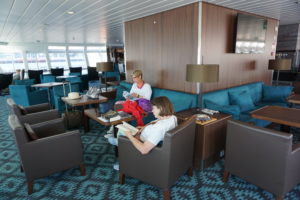
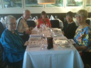
My wife, Jean, and friend Carolyn Torma relax in the lounge on the MS Nordnorge.
Boarding a cruise ship is more like joining a small, floating city. Once aboard, you can wander the decks for fresh air, you can chat with hundreds of people, converse with crew members, and take in sights both near and far away. You can break out that camera you just bought. And you can visit coastal cities for a few minutes or a few hours, depending on the itinerary.
Welcome to my final blog post on our trip to Norway in July 2017. I have promised and teased, but I am delivering after three prior installments about our flight to Norway; our time in Oslo; and most recently, our train trip to Bergen and our visit to its intriguing and highly edfying art museums.
When the day visit of our gang of five to the center of Bergen ended, we gathered our bags at the Clarion Hotel Admiral and boarded a shuttle bus to the dock where we checked our bags with Hurtigruten, a wonderful cruise line dedicated to sustainable practices, watched an instructional video on cruise safety, and boarded the ship. Perhaps I am a bit romantic but crossing the gangplank into a ship stirs more ancient memories of human experience than flying ever will. Humans have been sailing for thousands of years, traversing seas and oceans, and the only serious difference is that the ships have grown larger and more mechanized and, these days, electronic as well. But you are still floating close to the water and the weather and nature.
 You also know that you will be aboard this behemoth for several days. That makes accommodations important. In our case, in order to join the same cruise as our friends, my wife and I had to lose our inner cheapskate and splurge on a state room because the lower decks were sold out. Our friends were on Deck 3, but we were on Deck 6, in a room that had a nice television screen and a bed for two, plus a decent bathroom. Admittedly, things still seemed a little cramped, but how much time do you want to spend in your room? Especially as the ship moves north and the summer nights grow long above the Arctic Circle, the idea of sitting in a room seems almost absurd.
 Wander the decks! There is a whole world of Norwegian fjords to see out there. There was a promenade on Deck 5, one level below us, and the stairs with their gold-colored railings seemed like a grand way to get there, far more inviting than the elevator. There was the entire lounge on Deck 7, with an outdoor viewing area at the front of the ship, where you could sit outside and monitor the ship’s progress through passages that offered stunning scenery on every side. More than once, I sat there in a deck chair with the movie function turned on for a new Sony camera I had bought in anticipation of this trip. At lower latitudes near the beginning of the trip, this was often great fun. Later, as temperatures grew cooler farther north, it sometimes became less comfortable—but no less impressive.
Inside, we soon also discovered an entire world of Scandinavian cuisine that was previously not part of our daily experience. It’s not that my wife and I have not tried a wide range of international food. We simply had not visited Norway, nor spent nearly a week investigating buffet options for breakfast and lunch in the remarkable dining room on Deck 4, which offered a range of Norwegian pastries, dark breads with savory cheeses, herring, salmon, ham and beef, and all manner of vegetable dishes and soups. Dinner was served at assigned tables and times but allowed us to get to know an interesting and intellectually curious family of educators from Seattle. The food was one of the bigger surprises for me because I had not previously learned to regard Norwegian cuisine highly. Never mind all the stories you may have heard about lutefisk. After this trip, I stand corrected. The best of Norwegian cuisine is a salivating safari for sophisticated palates.
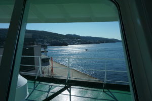
View out the front window of the lounge.
Amidst it all, relaxing in the lounge with a view of the shore in the distance or nearby, I plowed through my tome. On a long vacation, I like to take a long book I have wanted to read but never found the spare time to immerse myself in. For this trip, I tackled Doris Kearns Goodwin’s magisterial Team of Rivals, a 750-page exploration of Abraham Lincoln’s political genius in managing a team of strong wills and egos through the shoals of the Civil War. It filled the hours when I wanted to take a break from sightseeing and just enter another world and time. I chose well.
Viewing the Fjords
 It is difficult to do justice to the scenery in words alone, but the beauty of the blog is that I can insert photographs to enrich the story. I had a small, aging Fuji digital camera; my iPhone; and a newly acquired Sony digital with zoom lens enhancements and movie features, all of which I was still trying to master on the fly. It often offered more options than I intelligently knew how to manipulate or had time to learn, as breath-taking scenery was often just around the next bend in the fjord.
 There is nothing subtle about the Norwegian coast, but there is much that is sublime. It is not hard to imagine the awe of nature and the gods that must have filled the hearts of Vikings sailing along the coast or returning from their overseas explorations. Islands dot the sea lanes; some are inhabited, and many are not, usually because the terrain does not offer much solace. Shoreline communities occupy modest niches of flat land below hills and towering cliffs.
 No two fjords are ever the same. Each has its own unique topography, its own paths to sheltered ports, its own dramatic waterfalls crashing off mountainsides into the seas, its own snow-capped peaks above the humble human intrusions below. Norwegians at times are remarkable engineers, but there must still be a sense of our own puniness in the face of such lofty natural beauty. We could never replicate the work of millions of years of geological transformations of earth’s landscape. It is better to sit back, gaze in admiration, and appreciate it.
What is remarkable, nonetheless, is the mastery of coastal navigation, even if modern ships benefit from a range of electronic wizardry to avoid danger. In a part of the coast known as the Trollfjord in the Lofoten Islands, it is my recollection that we were told we were crossing a passage with only 450 meters between rocky outcrops hundreds of meters high. On a cruise ship housing nearly 500 passengers and crew members, that does not leave much room for error, but the passage, admittedly in calm seas, seemed effortless and very precise. Our ship approached the passage in the evening; I was captivated by the scenery for the entire time and filmed it for 12 minutes. I cannot recall anything I have seen that compares.
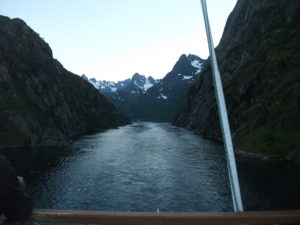
Passing through the Trollfjord.
Trondheim
Ports of call are a routine feature of cruises. In Norway, these are port cities along the coast, often away from the ocean itself within fjords, the long arms of the sea that often shelter such cities. On our second full day of the cruise, the MS Nordnorge docked in Trondheim for a 3 ½ hour visit. We disembarked and began a journey on foot to find Nidaros Cathedral, the oldest cathedral in Norway and the northernmost cathedral of its size in Europe. Trondheim was also at one time the capital; moving the capital south to Oslo, formerly known as Christiania, was a modern innovation. Nidaros Cathedral remains the scene of coronations for the nation’s constitutional monarchy.
 The walk to Nidaros, which was under a half-hour, took us along the Nidelva River, lined by some colorful apartments on the far side, with some interesting urban architecture on our side as we moved into the heart of the city. The site of the cathedral became apparent as we drew near because the building is surrounded by impressive grounds and fencing. The soaring worship space was completed in 1300 but begun around 1070, with much of the construction
  occurring after 1190. Tours require tickets at a modest price, which visitors can obtain in the nearby gift shop, whose sales help support maintenance of this massive space. The cathedral sits above the grave of St. Olav, the nation’s patron saint, a tenth-century Viking king who converted his subjects—and himself—to Christianity after learning about the faith in England, which experienced numerous Norse raids in the Middle Ages. One must marvel at its height and size given the lack of modern tools, but a tour guide informed us that masons were in the habit of leaving their initials on the bricks that formed the foundation and walls. The building has both the sense of inner darkness typical of buildings lacking modern Illumination and a sense of spaciousness emanating from its massive ceilings and the size of its sanctuary. Originally, it was the seat of the archdiocese, but suffered a demotion to a huge parish church for Trondheim following Norway’s turn toward the Reformation, when Lutheranism became the state church.
 Between its history and majestic architecture, my own judgment would be that, if one had time to visit only one thing in Trondheim, this would necessarily be the default choice. That said, we had a little time left after our tour. Jean and I, in touch with our friends by cell phone, wandered through a large, modern urban mall back toward the ship but stopped for a few minutes at a serendipitous discovery, a flowery pocket park inhabited by birds, where we simply imbibed the relaxing atmosphere in the middle of Norway’s third-largest city. Then we bought a couple of souvenirs at a shop atop the bridge we crossed as we made our way back to rejoin the cruise late in the afternoon. We still had a couple of hours to relax with our friends over drinks in the bar before dinner and another evening of scenery consumption.
 Bodø
Bodø
 The next day, our long stop was at Bodø, a smaller city whose second syllable is pronounced somewhat like the “oo” sound in the English word “foot.” (Pronouncing that will give English speakers a vague sense of that distinctive sound of Scandinavian languages.) A slightly longer stay in a smaller city gave us ample opportunity to explore, but without the obvious choice of anything like Nidaros. One intriguing aspect of the day was passing beneath a tall bridge lined with spectators observing the passing of our ship beneath. Norway has plenty of bridges, no surprise, but this sort of welcome was a pleasant surprise.
 In Bodø, one indicator of the changing cosmopolitan nature of Norwegian cities was the sign that greeted us not long after we became urban pedestrians again—Istanbul Kebab. Like other European nations, Norway has acquired its share of Middle Eastern immigrants, and restaurant options have diversified. No doubt, these newer options have also thrived as Norwegians seek a change of pace, just as Americans, Brits, and others have done. Still, even the shopping district near the shore affords an unhurried, uncrowded atmosphere that let us soak up the afternoon sun in peace and quiet.
Tromsø
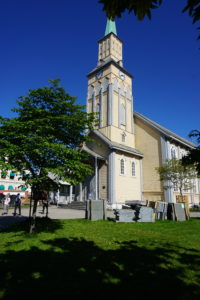
Tromso Cathedral
Our fourth full day took us ever farther north with a four-hour stop at Tromsø. This is the last major city on the journey north, and not hard to wander. With my interest piqued by Nidaros, I sought out the Tromsø Cathedral, just a few blocks from the shore, only to find that it was closed and undergoing renovations—signs of which abounded with construction equipment parked just outside on the somewhat spacious Kirkeparken that surrounds the building itself. Reduced to simply looking at the building from the street, we instead joined our friends in a visit to the nearby Tromsø Gift and Souvenir shop, which sported a stuffed bear outside that was a magnet for tourist selfies. It was a great place to look at gifts that someone back home might want, as well as those souvenir mugs and hot pads that line one’s cupboards.
 Once that novelty had worn off, however, we quickly discovered the Northern Norway Art Museum, which had a wonderful display of indigenous Sami clothing and handicrafts, with some explanation of the Sami culture that produced them. Here, I should note that one of the more moving lectures aboard ship, amid other daily offerings, was a presentation by a young Sami woman who was part of the Nordnorge crew. She shared stories of the discrimination suffered by Sami people at the hands of Norwegians, including herself in school and elsewhere. Things are looking up, and the king and queen offered an apology to the Sami on behalf of the nation, but racial and ethnic prejudice takes many forms and is not easily or quickly rooted out from any society.
The Sami number perhaps a modest 50,000 in modern Norway, a number larger than in any other Scandinavian nation or in Russia, where a small number also live. One of their traditional occupations has been herding reindeer, which are produced for their lean and nutritious meat, a result of consuming native grasses and herbs. The Sami, however, faced a serious public health crisis after the 1986 Chernobyl nuclear power accident in what is now Ukraine, as the released radiation dispersed westward over northern Scandinavia and contaminated the ground and the reindeer who roamed it. Many Sami, including the speaker, suffered some degree of radiation poisoning, which in her case produced red blotches across her back and shoulders. Her story offered a dramatic example of the environmental jeopardy facing indigenous populations around the world. To call it sobering is to understate the case. She indicated that, over three decades, those radiation levels have receded significantly but were not always regarded as a matter of concern by the Norwegian government. The Sami relied on their reindeer and suffered with them. Not everything in Norway involves love and kisses, and history must be accounted for. I had to respect Hurtigruten for offering such a heart-felt, sobering presentation amid a cruise meant largely for entertainment. If people did not hear this story here, when might they ever hear it?
Jean’s birthday dinner, complete with reindeer steak entree and cloudberry dessert.
On the last night of our voyage, our gang of five enjoyed a complimentary upgrade to a private three-course meal on Jean’s birthday. One of the entrée options was reindeer steak, which Jean and I chose. It is a dark red, very lean meat, but very tasty and tender. I may never have it again, the supply in places like Chicago being almost nonexistent. But it was well worth finding out. I also recall that Jean tried a dessert involving cloudberries, a species unique to northern Norway, mostly grown above the Arctic Circle. Hurtigruten is very good at local sourcing of agricultural produce for passenger consumption. They have identified small, sustainable producers along their route from whom they can obtain these products during the numerous short stops at ports of call, a practice that also supports the many small, struggling farmers in rural Norway.
Honningsvag
Our last full day involved a stop at Honningsvag, a small city in the North Cape area above the Arctic Circle as the shoreline bends east along the Arctic Ocean toward the Russian border. Honningsvag is at the southeastern edge of Nordkapp, translated as North Cape in English, actually a rugged island off the northern coast of Norway. By now, I was getting used to the possibility of waking up at 3 a.m. and peeking out our cabin window to see sunlight diffused across the seascape. Summer above the Arctic Circle can be disconcerting in that respect. It upsets your normal biological rhythms.
We visited the North Cape Museum, a small but key attraction in the city that sits at the water’s edge near the Hurtigruten dock.
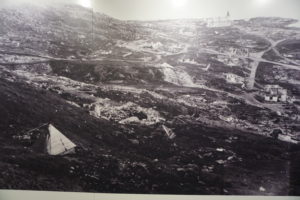
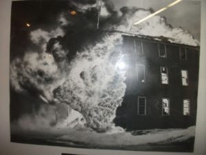
Honningsvag destroyed by German troops in the autumn of 1944. Photo taken in the museum exhibit.
There is one extremely sobering exhibit in the museum. To understand it, one must realize that all of Norway was occupied by the German army during World War II, after the country was betrayed by its own Vidkun Quisling, whose surname has become a synonym for “traitor.” Hundreds of thousands of German troops were pinned down in Norway because of fears of an Allied counterinvasion. As the war neared its end, Adolf Hitler also feared an invasion across the northern end of Scandinavia by the Red Army moving from Russia. Russia and Norway share the Arctic Ocean coast; Sweden and Finland reach only to the southern bounds of those two countries above the Article Circle. Hitler, to prevent such an incursion, ordered a scorched-earth policy for the German army in retreat.
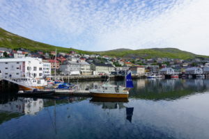
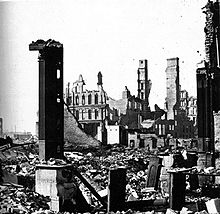
Honningsvag in 2017.
Several hundred soldiers had been stationed in Honningsvag. Very late in the war, they were ordered to torch the city, which they did. More than 20,000 citizens were evacuated to the mainland before that happened. When the war was over, and the residents of Honningsvag wanted to return home, a small contingent was sent to evaluate the state of their city. The museum’s photographs document the heartbreak they saw. With one notable exception, which was Kirkegata, the main Lutheran church south of the bay where the museum is located, everything in the city had been burned to the ground. My guess is that the church survived not because the Nazis spared it, but because the flames simply did not leap across the surrounding cemetery to the building. That church became the temporary home for the initial volunteers who helped rebuild until, step by step, the people of Honningsvag were able, with support from the national government, to rebuild their city and provide new, modern homes for thousands of displaced persons. It is a stunning reminder of the high cost of war and hatred but also offered insights into the heroism of the persistent and courageous Norwegian resistance, to which several museums throughout the nation have been dedicated.
Going Home
The next morning, at 9 a.m., our ship docked in Kirkenes, a small town that abuts the Russian border to the east. It was the end of our cruise, punctuated with a short bus ride to the local airport for a flight later that day to Oslo. On that flight, we had the chance to converse with a retired Norwegian airline pilot and his wife, who told us about an occasion on which the Russian government, seeking to dispose of Syrian refugees, had put them all on bicycles and sent them across the border into Kirkenes to let the Norwegian government deal with them. With a hint of sarcasm, he noted that the bicycles had to be destroyed once the refugees were taken into custody because the Russian vehicles did not meet Norwegian bicycle safety standards. I will let the reader make of this curious story what you will. I have no reason to doubt its veracity, but if true it certainly smacks of cynicism on the part of Russian officials.
Our three friends caught an earlier flight back to Bergen, where they chose to spend two more days. Jean and I stayed overnight at the Radisson Blu Airport Hotel, awoke for an early breakfast the next morning, and walked back across the pathway for a flight to London’s Heathrow Airport. There, with only a 75-minute layover to dash through the long halls of a monstrous facility, we made our way to a United flight back to Chicago. Our lives were about to return to normal.
Jim Schwab