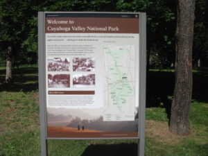
 Two weeks ago, I wrote about Cleveland’s Flats Entertainment District, where restaurants and bars now line the sides of the once filthy Cuyahoga River that now hosts boats and rowers. The Flats is but the last reach of a river that extends south into the Akron area. What has often been far less well known to outsiders than the more notorious industrial past of the river is the beautiful, forested valley that surrounds it upstream. In fact, about the time the Cuyahoga River was making environmental history by becoming a driving force behind passage of the Clean Water Act in 1972, U.S. Rep. John Seiberling, an antiwar Democrat from Akron, was leading an effort to designate a new national park. By 1974, he had won authorization for the creation of what is now the Cuyahoga Valley National Park, which remains a hidden treasure for many. I have personally discovered from discussing our trip that many people outside Ohio do not even know that the park exists.
For some interesting background on the politics and commitment behind the drive to create the park, I recommend a book I read several years ago about the life of John Seiberling, A Passion for the Land: John F. Seiberling and the Environmental Movement, by University of Akron emeritus history professor Daniel Nelson.
As for the Cuyahoga Valley National Park: Yosemite or Yellowstone it is not. Ohio, which became a state in 1803 and rapidly urbanized and industrialized afterwards, does not offer such massive public spaces for preservation. But it does contain gorgeous smaller valleys such as the Cuyahoga where protection of the landscape was still possible in the 1970s, and land was assembled from numerous small landowners and public spaces, woven in some cases into the fabric of the existing Metroparks system. In the area that contains the park, certain places seem to take one back in time to the 19th century, when Ohio built a canal to connect the Ohio River and Lake Erie and move agricultural and other products to markets a generation before the railroads began to dominate. Towns such as Peninsula and Boston, in the heart of the upper Cuyahoga Valley, still have the small town feel of that era in many ways, and many older homes have been preserved.
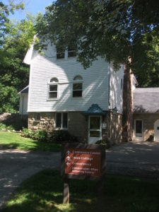 One, in fact, now hosts the Conservancy of the park, along Hines Hill Road just east of Boston, where one finds the visitor center. When we arrived, staffers were erecting a tent for an outdoor wedding that weekend. Curiously, we were also in town for an outdoor wedding for one of my nephews, but his was at Thorn Creek Winery in Aurora, several miles to the northeast. Although we merely stopped to investigate the scenery, and we were totally unexpected arrivals in the Conservancy office, the staff in the office treated us like honored guests, plying us with materials about the park and answering questions. Their friendliness is a tribute to the attitudes and sense of mission of both the Conservancy and the National Park Service itself.
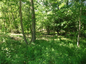
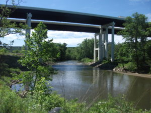 The park itself is a fantastic playground for hikers, bikers, backpackers, and even skiers and sledders. This is the north, after all. Near the Boston Visitor Center is the Boston Mills ski resort, offering some modest hills but great accessibility for people in the metropolitan area. But we arrived in June, and we began to wander the Towpath trail that leads away from the visitor center back into the forest, south beyond the massive bridge that carries Ohio Turnpike travelers past the Cuyahoga River below. From the height of the turnpike, one might never realize that what lies below is a national park, although it is certainly an impressive expanse of forested greenery. Down below, however, we were treated not to nature’s silence but to its music. For one thing, it was cicada season, so the buzz was all about the woods, but so were the birds, some of whom may have been feasting on cicadas. We surely could have seen other wildlife, had we come around dawn or dusk, but we were hiking in the late morning, when the deer and the rabbits and coyotes were well hidden. It is remarkable how easy it is to get away from everything, although the trails are popular enough to keep you in touch with other passing humans. The trails seemed to attract both young and elderly, providing a great excuse to all ages to stay in shape and in touch with nature. I began to wish I had tree and bird guides with me to better understand parts of my experience. If I still lived in the area, I might revisit with those guides, but it may be a while before I return.
 Our hiking visit occurred on a Thursday. Jean and I made a return visit on Friday, but of a different nature, and one that accommodated my sister, Carol, who lives nearby in North Royalton. She joined us at the parking lot on Rockside Road in Independence at 9 a.m. for the Cuyahoga Valley Scenic Railroad, a fine way for first-time visitors (and others) to see the park and its valley from a different perspective. The CVSR is a passenger train that uses tracks that largely run along the edge of the river. It is mostly run by volunteers who simply love the job of educating people about the local environment and its history. Audio is available that allows you to hear some of that history along with what one crew member jokingly referred to as “some pretty bad music,” most of it evoking a sense of bluegrass and Civil War and the early frontier with the use of banjos and bass fiddles. Call it “mood music.” The train ride takes about an hour and a half to get to Akron before turning around and bringing you back to where it started. Along the way, there are several stops that allow riders to get off and explore and then wait for the next train coming through. Explorers may want to get the schedule before they wander off. The price is only $15; as senior citizens we got tickets for $13. The money supports the train and is well worth it for the scenery along the way.
Because the park is interwoven among small towns and private property, the park leases some land for sustainable farming of vegetables and sheep, goats, and chickens, with some of the products finding their way to the Countryside Farmers’ Markets. The Conservancy staff also noted for us that there is now a visitor home in the park called Stanford House, built in 1843. It is not a bed and breakfast because visitors are on their own in sharing the use of a kitchen, but rooms can be rented starting at $50 per night, and the home provides immediate access to the Towpath Trail and the railroad, among other attractions.
Ultimately, the Cuyahoga Valley National Park is a study in adaptation, fitting a park into the scenery of a river valley that is also at the center of the large Cleveland-Akron metropolitan area. The park has been evolving since its advent in the 1980s and will continue to evolve as conditions change. But one major contribution it has already made is to stymie the urban sprawl that has so adversely affected much of the Cleveland area and allow residents to enjoy an expanse of refreshing greenery.
One reason it has taken two weeks to return to this blog and tell the story, since we returned to Chicago on June 12, is that I left again on June 19 for Grand Rapids, Michigan, to participate in the 40th annual conference of the Association of State Floodplain Managers, which was founded about the same time the national park was being organized. Today it is a growing organization of more than 17,000 floodplain managers, about 1,000 of whom attended the conference at the DeVos Convention Center, which sits along the Grand River opposite the Gerald R. Ford Presidential Museum, to which it is connected by a stone pedestrian bridge. ASFPM members have always been familiar with nature-based strategies for reducing flood damages and preserving the quality of rivers and streams, and the conference contained numerous discussions of such approaches. It occurred to me that what I had seen in the Cuyahoga Valley was one of the best possible approaches to floodplain management, the prevention of the encroachment of development to allow nature its due, preserving a natural setting that nonetheless endows humans with wonderful opportunities for outdoor recreation and exercise in an age when public health authorities worry about an epidemic of obesity. We have to make our cities attractive places for people to get the exercise they need. Many factors in the Cleveland metropolitan area, frankly, work against that goal, but the park exemplifies it. It is modern floodplain management at its best with a healthy dose of environmental protection in the bargain. The fact that the park is sprinkled with outdoor attractions like the Blossom Music Festival only serves to enhance that goal by acquainting people with what the park has to offer.
John Seiberling was clearly a visionary in fighting for the creation of the park in Congress. But every city has its environmental champions. It is the job of the rest of us to make it politically possible for them to survive and to achieve their objectives. We all benefit from a better quality of life when they do.
As for the title of this blog post: The Cuyahoga River derived its name from the local nomenclature of the Mohawk Indians, an Iroquois nation, who referred to the river as “crooked” because of the way it winds through the landscape, hence “crooked river.” (The Seneca, also Iroquois, used a similar name.) Meandering is nature’s way of diffusing the force of flood waters while distributing silt into the rich agricultural soils along the banks. Ohio grew up on such wealth. Now it is preserving some of it.
Jim Schwab